
The Navy Department Library
From the Sea to the Stars
A Chronicle of the U.S. Navy's Space and Space-related Activities, 1944-2009

From the Sea to the Stars:
A Chronicle of the U.S. Navy's Space and Space-related Activities,
1944-2009
Sponsored by
Deputy Assistant Secretary of the Navy (C3I and Space)
Dr Gary A. Federici
Edited by
The Applied Research Laboratory
The Pennsylvania State University
Revised and updated edition, 2010
CONTENTS
Illustrations
| Figures | |
| Figure 1. A successful Vanguard launch | 11 |
| Figure 2. APL's Aerobee rocket | 12 |
| Figure 3. The famous Sputnik-I, the world's first man-made satellite on orbit (USSR photo) | 17 |
| Figure 4. Echo satellite sphere, used by the Navy for pioneering satellite communications | 28 |
| Figure 5. Postage stamp commemorating the first space mail | 29 |
| Figure 6. GRAB-2 with turnstile antennas | 31 |
| Figure 7. Thor Ablestar launch vehicle at Cape Canaveral with GRAB-1 | 32 |
| Figure 8. Interior of a GRAB hut | 33 |
| Figure 9. Minitrack, the first U.S. satellite tracking system, 1956 | 35 |
| Figure 10. NAVSPASUR transmitter at Kickapoo Lake, Texas | 37 |
| Figure 11. NRL's Timation satellite | 43 |
| Figure 12. USNS Kingsport (AG-164) configured for communications demonstrations, 1963 | 49 |
| Figure 13. NRL's Lofti communications satellite | 53 |
| Figure 14. SolRAD-10 satellite | 59 |
| Figure 15. USNS Range Tracker (AGM-1), 1962 | 66 |
| Figure 16. APL's Transit navigation satellite (APL Photo) | 87 |
| Figure 17. TIP-II Navy navigation satellite undergoes pre-launch tests (APL photo) | 89 |
| Figure 18. An Outlaw Shark terminal installed in a Navy EP-3 aircraft | 94 |
| Figure 19. Artist's conception of a Global Positioning System (GPS) Satellite | 119 |
| Figure 20. A mobile version of the Tactical Receive Equipment (TRE) | 124 |
| Figure 21. Rendering of MUOS satellite | 175 |
| Figure 22. TacSat Program | 185 |
| Tables | |
| Table 1 - Experimental and Pre-production Transit Satellites | 27 |
| Table 2 - Locations of the 17 TRANET Stations | 34 |
| Table 3 - U.S. Space Surveillance System | 37 |
| Table 4 - The NRL Classified Programs in the 1960s | 54 |
| Table 5 - APL Environmental Research Satellites during the 1960s | 60 |
| Table 6 - Transit Improvement Program (TIP) Satellites | 89 |
Preface
The importance of space and space-related activities to support global military operations has expanded significantly over the past 50 years - and is still evolving. Today, the U.S. Navy is perhaps the most reliant of all the Services on space for communications, navigation, surveillance, weather, and oceanographic support.
In today's multi-dimensional environment it is important to recognize the historic role the Navy has played in space systems development. In 1958 the Naval Research Laboratory successfully launched one of the earliest man-made satellites (following the Soviet Union's two Sputniks and the U.S. Army's Redstone missile). During the same year, the Navy's Space Surveillance System was fielded to detect and track all man-made objects in space, and provide data for day-to-day operations of the Fleet, Fleet Marine Forces, and U.S. Space Command, until the system was turned over to the U.S. Air Force in 2004. In the early 1960s, while the Air Force and Central Intelligence Agency concentrated primarily on imagery from space, the Navy built and operated the world's first satellite system for collecting electronic intelligence. Throughout the 1960s, the Navy and Marine Corps provided the majority of astronauts for NASA's manned space flight program, and during this period the Navy also launched Transit, the world's first satellite navigation system that provided U.S. and Allied navies, and eventually the world's merchant ships, with primary navigation support until the appearance of the jointly acquired Global Positioning System.
In the 1970s the Navy led the way in developing satellites for communications at sea, and by 1980 the jointly acquired Fleet Satellite Communications system was in universal use for Navy's tactical and long-haul command and logistic support communications - eventually adopted by all the services. In the 1980s, with the National Reconnaissance Office, the Navy pioneered a breakthrough capability for delivering tactical reports directly to operational commanders and units at sea, urgently needed for targeting support of long-range weapons and other applications. The other Services soon adapted these capabilities and joint forces used them in the Persian Gulf War, which was dubbed "The First Space War." From the 1990s to present day, the Navy has continued to lead the way in demonstrating the direct delivery of satellite imagery to tactical commanders.
We are indebted to the late Dr. Gary A. Federici, who served as my principal advisor on Navy space technology and acquisition matters from 2008 to 2010, and who was a strong advocate for developing the tactical applications of space, for his efforts over the last quarter century in gathering and preserving this record of Navy space for future generations. We are also grateful to CAPT Kent B. Pelot, USN (Ret.), Naval-NRO Coordination Group, for leading the effort to bring this 2010 edition to completion. I am pleased to present this volume, which describes these and many other Naval space and space-related activities during the 50-year period from 1959 through 2009.

Sean J. Stackley
Assistant Secretary of the Navy
Research, Development, and Acquisition
30 July 2013
Acknowledgments
In the early 1980s, when tactical exploitation of space progressed most rapidly, Commander Fenton Carey of the Navy's Special Projects Office recognized the desirability of documenting the Navy's key role (along with the other military services and the national agencies) in implementing these applications. He asked Mr. James Wilson (a staff member of the Naval Studies Board) to compile from official NASA and DoD sources an extensive chronology of the significant events in the Navy's involvement with space activities. As there was not, at that time, a Navy office with appropriate responsibility for publishing such a history, Rear Admiral Tom Betterton, head of the Navy's Special Projects Office, directed that custody of Wilson's chronology be given to me while at the Center for Naval Analyses (CNA) and supporting his office.
Several years later, with the strong support and leadership of the commander of the Naval Space Command, then Rear Admiral Lyle Bien, I obtained funding to produce a Navy space history. In 1994, I asked Dr. Robert Hess to draft a Navy space history, drawing heavily on Mr. Wilson's chronology and other sources. The resulting document was not widely disseminated, however, as it was highly classified.
In 1997, Dr. Ron Potts provided additional materials on the Navy's classified work, and Mr. Fred Glaeser, professional consultant with the Navy's Tactical Exploitation of National Capabilities (TENCAP) Office, edited and expanded the Navy Space History and revised the title to "From the Sea to the Stars." The resulting document, still highly classified, is on file at the National Reconnaissance Office (NRO) in the archives of the NRO Historian, accessible to those with appropriate security clearances. At the request of the U.S. Naval Reserves, we produced an unclassified extract of this document for the Director of Naval History, Washington, DC, by removing all classified sections from the document. In 2003, this unclassified extract was again revised and updated to include events through the year 2000.
In 2004, I assumed the position of Deputy Assistant Secretary of the Navy for C4I and Space, and pressed to bring the effort to completion. By 2008, the manuscript was ready to be finalized. I contracted with The Pennsylvania State University Applied Research Laboratory to edit the previous version and coordinate with the original authors and other contributors to produce the work appearing here.
The principal authors of the current version were Dr. Robert Hess, Dr. Bruce Wald, Mr. Kent Pelot, and Mr. Fred Glaeser. Other significant contributors were Mr. Lee Hammarstrom, Mr. Michael Hurley, Dr. Robert McCoy, Mr. Vance Morrison, Mr. Randy Nees, Mr. John Newell, Mr. Troy Tworek, Dr. Wayne Vaneman, Mr. Gegory Tornatore, and the OPNAV N6 staff. The manuscript was reviewed by Admiral William Smith (Ret), Rear Admiral Thomas Betterton (Ret), and Rear Admiral Rand Fisher (Ret). Dr. Richard Hughes at Penn State ARL served as the editor-in-chief. Special thanks go to Mr. John Thackrah, who provided strong encouragement and support, and to the National Reconnaissance Office, which provided a thorough security review of the manuscript.
Dr. Gary A. Federici
Deputy Assistant Secretary of the Navy (C3I and Space)
October 2009
--xv--
Introduction
The operators of early Navy ships, like all seafarers, depended on accurate observations of the moon and the planets, along with the sun and other stars, for navigation when sailing beyond the sight of shore landmarks and navigation aids. The Naval Observatory, established in 1830, worked to improve the knowledge of heavenly bodies by computing and publishing their accurate positions and movements and developing improvements in the equipment (including chronometry) used to make accurate measurements of them - a precursor to the Navy's engagement with artificial satellite applications a century and a half later.
This book tells the story of the U.S. Navy's first half century of space and space-related activities to support its sea, air, and land-projection operations. Much of its satellite capability was acquired jointly in cooperation with the other military services and agencies of the U.S. It is important to note that the United States does not at this writing have either spacecraft-based weapons systems or plans to acquire them (and if it did, that their acquisition and operation would very likely come under the Air Force rather than the Navy.)
During the roughly half century encompassed by this story, important changes occurred in the world geopolitical situation, the Defense Department organizational structure, and some Navy weapons systems and tactics. This history, therefore, is divided by chapters into epochs reflecting the changing circumstances.
Chapter 1, 1944-1961, reports how the Navy first became involved in space programs. Having acquired extensive technical experience with rockets and high-altitude space probes during the years immediately following World War II, the Navy was in a position to respond quickly to the international challenge when the Soviets unexpectedly orbited the world's first satellite, Sputnik, in October 1957. The U.S. Navy's first satellite was launched into earth orbit in March 1958. The Navy then participated extensively in both the nation's "scientific" satellite program (unclassified) under the National Aeronautics and Space Agency and in the (classified) "military" satellite program under the Defense Department. During this epoch the Navy also developed and operated the nation's spacecraft tracking systems, while also making significant contributions to advancement of spacecraft technology.
Chapter 2, 1961-1970, was the era during which the nation was concerned with satellites primarily for strategic defense. A DoD decision made in 1961 to put all military satellite systems acquisition and operation under the Air Force caught the Navy by surprise. At that time the possibility of strategic nuclear exchange with the Soviet Union fronted national concern, and the Air Force accordingly focused its space systems on providing strategic warning, collection of information for the national intelligence community, and providing operational support for the Strategic Air Command. Within the bounds of these constraints, the Navy continued to make some significant contributions during this epoch. The Navy, along with the Marine Corps, provided over half the astronauts for NASA's Mercury, Gemini, and Apollo manned-spacecraft flight programs;
--1--
provided the range instrumentation ships, and operated the extensive spacecraft recovery force. The Navy's space-based environmental sensing programs were continued. Under a military program supporting Navy strategic missile submarine operations, the Navy developed and fielded the world's first space-based navigation system, Transit (although this system eventually became unclassified and was used worldwide commercially and by other navies). And under the unclassified cover of environmental sensing programs of these years, the Navy developed the world's first electronic reconnaissance satellite, DYNO, also called GRAB, which was subsequently placed under a classified program of the National Reconnaissance Office. Finally, Navy research during this era continued making significant advances in satellite technology.
Chapter 3 recounts the emergence of Navy tactical applications of space that occurred throughout the 1970s. As a result of the Cuban missile crisis the Soviets decided to build up anti-ship forces to challenge the U.S. Navy worldwide, and by the early 1970s their enormous investment in tactical missile ships and submarines was evident in increasing Soviet deployments in strength worldwide. Furthermore, these anti-ship missile forces were directly supported by the Soviet navy's surveillance and reconnaissance satellites. In 1970, the Secretary of Defense canceled the 1961 Directive and issued a new Directive, which authorized all military services to develop space systems under DoD oversight. A new era of Navy space development began.
The Navy had recognized increasingly urgent needs to replace its former worldwide network of land-based communications-relay stations and navigation stations that supported its deployed tactical forces, as well as the need to supplement area surveillance coverage by shore-based surveillance and maritime patrol aircraft. The Navy also recognized an urgent need to improve its anti-ship targeting-support capability for its own long-range anti-ship missiles at distances over the horizon from the sensors of their launching platforms. Navy leaders, recognizing that satellites could provide much of the answer to each of these emerging U.S. tactical requirements, quickly took advantage of the new DoD Directive. Navy strengthened its space organization, consolidating its space acquisition interests in a Navy Space Project Office initially under the Chief of Navy Material, and later under the Naval Electronic Systems Command (NAVELEX). In 1971, soon after the new directive was signed, DoD authorized the Navy to develop the Fleet Satellite Communications System for global tactical communications, and a joint program was begun. Navy also joined actively with the other services in the program to develop the new and improved satellite navigation system (GPS), which adopted the Navy's clock technology and system design. In satellite reconnaissance, Navy initiated developments and operational exercises during this period that demonstrated the capability and value of satellite surveillance and reconnaissance for tactical warning, anti-ship targeting, and tactical situation awareness. Much of the Navy's space budget during this epoch, however, was invested in developing, procuring, and installing shipboard user terminals.
Chapter 4 reports the maturing of Navy space-based tactical support that took place from 1980 through 1991. By 1980 it was evident to both the U.S.S.R and the U.S. that tactical war at sea was a more likely Cold War contingency than exchange of strategic missiles, and so both shifted their plans and preparations accordingly. The
--2--
year 1980 also marked the beginning of a period of remarkable transformation within the U.S. Department of Defense and the services. Under President Reagan, an outspoken supporter of a strong military, U.S. defense budgets were dramatically increased, and a controversial new Secretary of the Navy began to inject a sense of new purpose into the fleet. The Navy took steps to further strengthen its space organization: in 1981 a Navy Space Systems Division was created on the staff of the Chief of Naval Operations; in 1983 a Naval Space Command was established to be the Navy's operational component command under the U.S. (joint) Space Command; in 1985 NAVELEX was renamed as the Space and Naval Warfare Systems Command (SPAWAR), and the previously consolidated Navy/NRO responsibilities were assigned to two separate Flag billets; the Naval Center for Space Technology was established; and a System Applications Program Office was formed under the Navy-managed Program Office of the NRO. The jointly acquired GPS navigation system became operational in the fleet in the late 1980s. During this epoch the Navy also shook longstanding U.S. intelligence concepts by consummating the ability to distribute surveillance/reconnaissance data from national satellite systems directly to Navy tactical users (adopted eventually by all the services).
Chapter 5 describes the transition of the Navy space program from 1992 until 2003. Following the dissolution of the U.S.S.R. in 1991, the Soviet Navy all but vanished as a threat. With that disappeared the focus of U.S. Navy planners and decision-makers whose experience during the previous three decades had been primarily in preparation against the Soviet navy. In its place there quickly arose the possibility of multiple conflicts throughout the world, with a potential role of the U.S. Navy primarily as a supporting force in joint-service operations that emphasized land warfare. The Navy's Tomahawk anti-ship missiles in deployed ships and submarines were replaced in 1992 by the tactical land-attack variant, with the result that the need for Navy satellite support against sea targets languished. Much attention was turned to correcting Navy (and other service) communications and intelligence shortfalls for land operations that had been experienced in the Gulf War and Bosnia, and a crash program was undertaken to equip all U.S. major combatant ships with terminals to receive EHF and SHF wideband communications. Building on the seminal work of the previous decade, this became a golden age for the Navy's TENCAP (Tactical Exploitation of National Capabilities) organization, due in large part to significantly increased cooperation by U.S. intelligence agencies - since the Gulf War, those agencies had to justify their budgets in terms of supporting tactical combat forces.
But the foregoing era also became one of some uncertainty for the future of Navy space. While the fleet continued to be fully dependent on satellites for communications, navigation, and surveillance, it was becoming less clear how space systems that might be needed for future Navy-unique requirements might be acquired. In 1992, the Navy-managed Program C of the National Reconnaissance Office was disestablished as part of a functional reorganization. Although its Navy personnel remained in the new jointly staffed Program Office, and the Program Director remained a Navy Captain, Navy no longer had a uniquely identified corporate role in the program that had pioneered applications of national satellite surveillance/reconnaissance for tactical users. In
--3--
addition, after 1993, Navy no longer had a flag presence in the NRO. In 2000 the new Secretary of Defense made it clear that the Air Force was to be designated, once again, as Executive Agent for all space major defense acquisition programs (a policy that was formalized by a DoD policy directive in 2003). The one major exception was the acquisition of tactical satellite communications, which remained under Navy management. In 2002 the Navy disestablished its Naval Space Command; its functions were assigned to the Naval Network Warfare Command, and in 2004 the Naval Space Surveillance System was turned over to the Air Force.
The uncertainty with respect to the Navy's future role in the National Reconnaissance Office was addressed in 1997 by a panel convened under retired Admiral William B. Smith. Recommendations by the Panel for reassigning a Navy acquisition flag to the NRO and broadening Navy's role in the NRO by redistributing Navy personnel throughout all of its major programs were implemented. A second Panel was convened under Admiral Smith in 2001 to address Navy's strategy with respect to all of the National Security Space programs, leadership of which had been consolidated under the Under Secretary of the Air Force who was dual-hatted as DoD Executive Agent for Space and Director of the NRO. The Panel recognized that the Air Force as Executive Agent for Space would have to continue its practice of building tactical systems for joint use based on "common-user" requirements, so that if Navy-unique space requirements were to be satisfied in the future, Navy personnel would have to participate actively throughout the entire development and acquisition process for each system of Navy interest. For this to happen, the Navy would have to continue to develop and maintain a cadre of personnel qualified in space systems acquisition and operational applications, sustain a program of space research and technology, and put a flag officer in charge.
Chapter 6 addresses the resurgence and evolution of Navy space activities and the implementation of the recommendations of the Second Smith Panel after 2003. The Secretary of the Navy promulgated a new Navy space policy in 2004. Funding for Navy space research and technology was provided, to be administered by the Office of Naval Research. In 2004, a flag-level Program Executive Office was established for Space Systems, headed by the dual-hatted Navy flag officer in the NRO. The Navy Secretary issued a formal directive to recruit, educate, and qualify a professional Space Cadre.
(By the end of 2008 this cadre had grown to 850 active duty officers serving in the National Reconnaissance Office, OPNAV staff, and space-related billets at various joint and Navy commands, and the fleet; 140 Reserve officers, and over 300 civilians.) In the fleet, the jointly acquired Global Broadcast Service became widely used during this epoch, consolidating direct broadcast of national geospatial intelligence, or imaging, information. The Operational Support Office of the NRO, modeled after the Navy's former System Applications Program Office, continued to help improve national interfaces with users by developing and fielding equipment for Navy surface ship, submarines and aircraft (as well as for Army, Marine Corps, and Air Force tactical users), and by working directly with Navy and other systems-acquisition offices to integrate the information into combat-system designs. In view of Navy's experience and success in developing and operating the UHF Follow-On (UFO) satellites in the 1990s,
--4--
it was decided that acquisition of the new Mobile User Objective System (MUOS) communications satellite system would be Navy managed. (MUOS, scheduled for on-orbit capability commencing in 2011, was the only major satellite acquisition program by the Navy during the 2000s, supplemented by the Naval Research Laboratory's experimental Tactical Satellites (TacSats), sponsored by the Defense Department's Office of Force Transformation and later, by the Air Force-led Operationally Responsive Space Office.)
The Appendices list the Navy offices in the Office of the Chief of Naval Operations; the Navy bureaus, system commands, and research and development laboratories and facilities; the Naval Space (Operations) Command; and the Office of the Secretary of the Navy that had principal responsibility for the Navy's space and space-related activities, with respective chronologies of the directors and managers who held these offices. The Appendices also contain a list of Naval personnel recognized by the National Reconnaissance Office as space pioneers, and recognition of key contributors that helped to make national system direct-broadcast capability to the fleet a reality.
The year 2009 is an appropriate ending point to this chronicle, as it marks fifty years since the Chief of Naval Operations identified and promulgated nine requirements foreseen by the Navy for space capabilities. This half century spans the Cold War and U.S. engagements in Southeast Asia, the Balkans, and the Middle East. During this period the Navy grew increasingly dependent on using space technology to support its tactical and strategic missions. This book concludes with an epilogue that summarizes the respective degrees to which those nine Navy requirements for space capabilities were fulfilled in the fifty intervening years after their promulgation.
--5--
[blank page]
--6--
CHAPTER 1 - THE NAVY GETS INVOLVED IN SPACE (1944-1961)
During the century leading up to World War II, there had been no lack of imagination as to the potential applications of space. In 1865, for example, French writer Jules Verne had fired imaginations with his famous book, "From the Earth to the Moon"; his spaceship was remarkably prophetic of developments that occurred a century later. Verne's spaceship was launched from a giant cannon, and spacecraft recovery was accomplished by splashdown in the sea. (At a 1987 AIAA/DARPA Conference at the Naval Postgraduate School, an electromagnetic gun was actually proposed as a modern means for placing satellites in orbit.) A very popular comic strip during the 1930s was "Buck Rogers in the 25th Century," whose rocket-propelled hero crossed the Galaxy in a variety of spacecraft.
Of course, the Navy, from its beginnings, had a vital interest in space. Navigation in the open ocean depended on accurate observations of the moon, the planets, the sun, and the stars. In 1830, the Navy established the Naval Observatory in Washington, DC to improve the knowledge of heavenly bodies, publish their accurate positions and movements, and develop improvements in the equipment (including chronometry) used to make accurate measurements of them. This concerted effort on celestial navigation aids served as a forerunner of the Navy's space applications with artificial satellites a century and a half later.
The knowledge required to place military satellites in orbit predated the capability to do so by a considerable period. The laws governing motion of the planets, artificial satellites, and eventually ballistic missiles had been discovered by Johannes Kepler in the early 1600s. Over the years, these scientific laws became well understood by military scientists and mathematicians.
The first U.S. space-advocacy group, the "American Interplanetary Society," was founded in 1930. But the Russians appear to be the first to have seriously contemplated exploitation of space; in 1903, Konstantin Tsiolkovsky published a report on rocket propulsion for space vehicles. Several treatises on space travel and rocketing followed after the Communists came to power. The USSR's "Society for the Study of Interplanetary Travel" was founded in 1924 (but disbanded in the 1930's).
During World War II and even before, the height advantage that naval aircraft offered as observation platforms for wide-area surveillance, reconnaissance, early warning, and targeting at sea had become obvious. These operations gave the Navy experience and insight into the potential advantages of the even higher altitudes of artificial earth satellites to support naval and military operations in the future (a lesson also learned by the Army Air Corps, soon to become the Air Force.)
Early on, rockets were recognized as the only practical way to put spacecraft into orbit. The physical laws of today's rocket propulsion (as well as the movements of
--7--
objects in space) had been developed by Isaac Newton by 1687. Rocket propulsion for military weaponry was developed initially in China and was refined during the eighteenth century by Britain, Austria, and Russia. The theory of rocket power was highly refined by Russian scientists in the early 1900s. In the United States, Robert Goddard conducted the first launch of a liquid propellant rocket in 1926. During the 1930s, rocket research progressed in Germany, the Soviet Union, and the U.S.
U.S. Navy scientists and engineers contributed to the ongoing progress with rockets. From 1941 to 1945, the Navy contracted with the California Institute of Technology to establish and operate the Naval Ordnance Test Station at China Lake, California, and the tests there included rockets for naval weapons. At the Engineering Experiment Station, Annapolis, Maryland, a Navy team working on jet-assisted take-off (JATO) rockets for seaplanes made discoveries concerning spontaneous ignition of liquid propellants, which contributed significantly to the U.S. rocket development program. During World War II, the Navy established a Jet-Propelled Missile Board which, in response to the threat to Navy ships from Japanese Kamikaze attackers, authorized work on a surface-to-air missile called the Lark. The Lark featured a liquid-propellant main engine and solid-propellant booster, with midcourse correction, semiactive homing, and terminal guidance. (The Lark missile was not ready before hostilities ended, but was tested after the war.)
Meanwhile, during World War II, German rocketeers under the technical direction of Wernher von Braun developed powerful V-2 rocket-powered missiles. (In World War I, the Germans had fielded long-range artillery and bombarded Paris from the German lines, and, because of this, the Treaty of Versailles forbade future German development of heavy artillery; the treaty, however, said nothing to forbid rocket development.) In 1931, the German military established a rocket research facility at Kummersdorf Weapons Range, near Berlin. The first civilian employee at this facility was von Braun.
In 1937, this facility was moved to Peenemunde on the Baltic Coast. The first test flight of a V-2 rocket was made in October 1942, and the V-2 became operational in September 1944, only a few months before the end of World War II in Europe. Germany bombarded London and both Antwerp and Liege, Belgium, with thousands of V-2s from German mobile bases during the last months of the war.
At the end of that war, the Soviet Army captured most of the German V-2 production facilities, while the Western allies captured the R&D facilities and most of the rocket technicians and scientists, including von Braun, as part of Operation Paperclip. With the help of engineers of the General Electric Company, the Army assembled about eighty V-2 rockets from the captured parts. The U.S. now had rockets capable of lifting payloads into space (but not yet into orbit). The U.S. Army offered some of the captured V-2s to the U.S. Navy, and the offer was accepted on behalf of the Navy by the Naval Research Laboratory (NRL) and by the (Navy-sponsored) Applied Physics Laboratory (APL) of Johns Hopkins University.
The history of Navy Space begins, in effect, in 1944. (By 1945, both the Naval Research Laboratory and the Applied Physics Laboratory were using the captured
--8--
German V-2 rockets for atmospheric soundings. In 1947, the Navy launched a V-2 rocket from the deck of the USS Midway (CVA-41), demonstrating that such weapons could be launched at sea.)
Early Navy Space Programs (1944-1958)
During this early period, the Navy had two programs in which space probes were used for scientific research, and both of these programs led to development of operational U.S. rockets. One program, conducted by the Naval Research Laboratory in Washington, DC, developed and operated the U.S. Viking rocket. The other program, executed by the Applied Physics Laboratory of Johns Hopkins University, resulted in development of the Aerobee rocket.
In the mid-1940s, the U.S. Navy began taking scientific measurements in the upper atmosphere and in the space above it. These experiments were initially launched on the German rockets captured in World War II and then subsequently on rockets developed specifically for this purpose by the Naval Research Laboratory (NRL) and the Applied Physics Laboratory (APL). These rockets were only capable of lifting the probe payloads to high altitude, which then fell back to earth. (It was not until 1958 that the Navy was able to launch rockets that achieved sufficient altitude and speed to actually place payloads in orbit around the earth.)
Naval Research Laboratory's Space Probes
Construction of the Naval Experimental and Research Laboratory, authorized by Congress on 4 March 1917, began on 6 December 1920 on the Potomac River in Washington, D.C., about two miles from the Capitol. The name was changed to the Naval Research Laboratory in the mid-1920s.
In 1944, toward the close of World War II, the Naval Research Laboratory established its Rocket-Sonde Research Branch to measure and study solar and cosmic radiations in the upper atmosphere, primarily to better understand their effects on Navy communications and to help predict usable radio channels. This step toward research conducted in outer space was the first such program in the United States.
In 1946, NRL was offered the use of some of the captured German V-2 rockets. Engineers and scientists at NRL equipped their V-2s with instrumentation for probing radiation in the earth's upper atmosphere. On 28 June 1946, NRL launched the first of these missions. This first rocket, which reached an altitude of 67 miles, carried radio transmitters for telemetry transmissions, a spectrograph, pressure and temperature gauges, and a Geiger counter telescope to probe for cosmic rays.
Between 1946 and 1952, NRL launched sixty-three of these modified V-2 rockets, most of them from White Sands, New Mexico. The rockets carried a total of over twenty tons of scientific instrumentation, to altitudes ranging between 50 and 100 miles.
--9--
Applied Physics Laboratory's Space Probes
Military work at the Applied Physics Laboratory (APL) of the Johns Hopkins University had begun during World War II when a small group of scientists and engineers designed a very successful proximity fuse for U.S. antiaircraft guns. (Over time, APL was involved in developing the Polaris ballistic missile system, the Terrier, Talos, and Tarter antiaircraft missiles, the Tomahawk anti-ship cruise missile, and the Aegis system for fleet air defense.)
Prior to World War II, the Navy had discovered that the upper atmosphere had a significant impact on long-range communications. Because the mechanisms that affected communications were not well understood (and could not be reliably predicted), Navy-sponsored post-war research was directed toward learning more about the upper atmosphere. Part of this effort included work by APL, using captured German V-2 rockets, under the direction of James Van Allen.
The V-2s reached an average altitude of 70 miles and a maximum altitude of 114 miles, but the rocket could not remain in the upper reaches of the atmosphere more than a few minutes. To obtain the data Van Allen wanted, the rocket had to rise more than twenty-two miles above the earth, and from the time it passed that level on the way up until it came hurtling back down, the instruments had only about five minutes to obtain their data. During that brief time, data from particle counters were recorded on rotating steel cylinders in the rocket's nose and were transmitted via telemetry to receiving stations on the ground. Since the rockets crashed when they returned to earth, the steel cylinders were constructed to withstand extreme conditions. One V-2 nose cone was lost in the desert for nearly two years before it was finally recovered and its data retrieved.
Van Allen and his team of APL physicists proved particularly adept at designing experiments to take advantage of the limited window of opportunity provided by the V-2s. On 30 July 1948, a rocket bearing APL instruments soared 100 miles above the earth's surface, setting a high-altitude record and bringing back a wealth of information about the cosmic ray particles that constantly bombard the earth. According to Van Allen's findings, secondary particles (known as mesons) formed by the collisions of cosmic protons with the earth's upper atmosphere were far more abundant than previously believed.
--10--
The Rockets
In the late 1940s, the Naval Research Laboratory developed the Viking rocket as a replacement for its then-dwindling supplies of German-built V-2s. The first successful launch of a Viking took place at White Sands Proving Grounds in 1949. The next year, one of the Vikings was launched from the deck of the USS Norton Sound (AVM-1). It achieved what was at that time the record high altitude of 106 miles - almost but not quite high enough to put a payload into low-earth orbit.
The Viking rocket was used extensively during the International Geophysical Year, 1957-1958, and the Vanguard rocket (Figure 3) which placed the first Navy satellite in space in 1958 was a derivative of the Viking. All of the Navy's unused Viking rockets, however, were transferred by NRL to the National Aeronautic and Space Administration (NASA) (along with the entire Vanguard program) when NASA was formed the next year.

Although APL also continued to enjoy access to selected V-2 launches, the limited supply of these rockets persuaded the APL director to recommend that the Laboratory develop its own simpler, relatively inexpensive alternative. Such a project would also enable the Laboratory to obtain first-hand experience with liquid rockets as potential guided-missile boosters. Under a Navy agreement with APL, the Navy's Bureau of Ordnance funded the project, APL provided the design and technical supervision, and associate contractors in this case, Aerojet Corporation, Douglas Aircraft (later McDonnell-Douglas), and the Jet Propulsion Laboratory of the California Institute of Technology performed the actual engineering and production work. The result was the Aerobee rocket (Figure 1), a 20-ft long, 1,650 lb liquid-fueled rocket, much smaller than the V-2 and capable of reaching a height of 75 miles at speeds of 35,000 miles/hour (far higher and faster than the Army's Wac Corporal, the only other large American rocket in existence at that time.)
An Aerobee could carry a payload of 150 lbs in its 88-in long, pressure-tight nose cone. The first of these rockets was launched on 24 November 1947, for a flight of only 35 seconds. The second Aerobee launch on 5 March 1948 was highly successful, providing valuable new data on the intensity and distribution of cosmic rays above the appreciable atmosphere.
To provide a more expansive testing range in a variety of latitudes for both the V-2 and the Aerobee, the Navy converted a seaplane tender, the USS Norton Sound, into a seagoing rocket laboratory in 1948 and dispatched the ship to the Pacific Ocean. With its deck protected by a special metal sheath, Norton Sound launched numerous APL rockets in 1948-1949, obtaining through telemetry significant data on cosmic ray intensity and other atmospheric phenomena, including the dimensions of the ozone layer and the extent of solar radiation.
By January 1951, when APL's high-altitude program came to an end, APL had launched nine V-2 and twenty-one Aerobee rockets from sites around the globe.
In 1947, two engineers from the Radio Countermeasures Branch at the Naval Research Laboratory, James Trexler and Howard Lorenzen, began to experiment with methods to capture radar signals originating in the Soviet Union and Europe that (under certain atmospheric conditions) bounced off the ionosphere. However, in June 1948, after becoming aware of a study on the possibility of using the moon as a communications relay, Trexler shifted his focus to capturing radar signals reflected from the moon. (The U.S. Army's Signal R&D Laboratory had bounced radar signals off the moon as early as 1946. The Army concluded, however, that nothing of military use would come of this work and consequently ended the experiments.)
Early experimental successes with large long-wire antennas designed for observation of the moon led to the creation and funding of Project PAMOR (PAssive MOon Relay) in 1950. Trexler calculated that with a sufficiently high gain antenna, one could receive radar and communications signals originating in the Soviet Union and

--12--
reflected from the moon during those periods when the moon was visible from both the transmitting and receiving points on the Earth. To achieve a large aperture antenna with consequently high gain at an affordable price, he arranged to have a parabolic hole dug in the ground near Stump Neck, Maryland, which was then lined with reflecting mesh. Rather than moving the entire antenna (as is ordinarily done to point a radar antenna), a small feed near the focal point of the parabola could be rotated to provide limited steerability of the antenna's beam. The elliptical opening of the antenna was 220 ft by 263 ft and was, for a brief time, the largest parabolic antenna in the world.
The first radar contact with the moon was initiated in October 1951, and the received echo was of surprisingly high fidelity. Trexler and others studied the nature of these reflections and found that despite the Moon being a diffuse optical reflector, it was also a quasi-smooth radio reflector, with a substantial part of the reflection coming from a specular "hot spot." (Due to its potential military value, this discovery was not reported in the open literature until some years later.) The success of this and subsequent trials proved that the project's potential was greater than originally anticipated, and it eventually led to an entirely new, unclassified project that was called Communications Moon Relay, or CMR (discussed below).
By 1954, however, the Stump Neck antenna had proven itself too weak to consistently and reliably collect Soviet radar signals. Trexler calculated that a much larger antenna would be required to achieve the desired performance objectives. Plans were made and eventually approved for a 600-ft diameter fully steerable antenna to be constructed near Sugar Grove, West Virginia. The site was selected because it was free of industrial sources of radio noise and in a valley whose walls would shield it from remote noise sources. A National Radio Quiet Zone was established in 1958 to protect the radio environment, and the National Science Foundation built a smaller radio telescope within the zone in Green Bank, West Virginia.
The 600-ft radio telescope would have been the largest moveable structure in the world, surpassing the famous Jodrell Bank telescope of 275-ft diameter. Construction began in 1959, but the estimated cost to complete the Sugar Grove project rose to over $200,000,000, leading to delays in its completion. Meanwhile, a group of NRL engineers, who worked in the same Branch only fifty feet away from the group designing the Sugar Grove telescope, had led the design and development of the first electronic reconnaissance satellite (see page 30) in a project that cost less than $10,000,000. Because such satellites could intercept emanations from the Soviet Union more effectively, the construction of the radio telescope was cancelled after only its turntable and pintle bearing had been completed. However, a much smaller-diameter radio telescope had been installed at the site for supporting research and was subsequently put to work relaying data back to the United States that electronic reconnaissance ships such as the USS Liberty had collected (see page 46). This operation required relatively large-diameter antennas on the ships and was discontinued when communications satellites with active transponders requiring much smaller terminal antennas became available.
--13--
In the years following the 1962 cancellation, the 600-ft radio telescope project was often called a fiasco, referred to as an example of engineering overreach, and, because radio astronomy was the cover story for the project, was called a scientific boondoggle by those who opposed Government investment in pure science. The NRL historian officially revealed the true story of the radio telescope in 2001.
As mentioned above, the 1951 experiments at Stump Neck produced intense interest in using the moon as a communications relay, and experiments began shortly thereafter. On 24 July 1954, NRL transmitted the first voice messages via the earth-moon-earth path using a 100-watt 220-MHz communications transmitter. Transcontinental communications were demonstrated in November 1955 when teletype messages were transmitted from Washington, DC, to San Diego, CA. Two months later, NRL conducted transoceanic communications via moon-satellite transmissions between Washington, DC, and Hawaii.
Early Navy-Air Force Competition over Space Development
After World War II, the earliest U.S. military study into the feasibility of artificial earth-satellites was conducted by the Navy. The Navy's Bureau of Aeronautics formed a "Committee for Evaluating the Feasibility of Space Rocketry" on 9 October 1945, and the committee prepared a satellite development proposal, which the Bureau turned over to industry for refinement. Based on this effort, the Navy submitted its first satellite-development proposal on 7 March 1946 to the joint Army and Navy Aeronautical Board, a group established during WWII to coordinate R&D between the Army Air Corps and the Navy.
The Army Air Corps (soon to become the U.S. Air Force) was caught off guard by the Navy proposal, and the next meeting of the joint Aeronautic Board's R&D Committee was delayed until 14 May 1946 to give the Army Air Corps time to prepare a response. In a crash effort to develop "equal competence" with the Navy on satellites, and thus avoid being excluded from future military space research, General Curtis Le May, then director of R&D for the Army Air Force, assigned Douglas Aircraft Company and its Project RAND Group to undertake a three-month study on the service's behalf. Given the constraints on time, RAND produced a remarkably comprehensive report, not only on the technical feasibility but also on the future utility of space vehicles.
While RAND prepared its assessment, the Commanding General of the Army Air Forces was informed of the Navy satellite development proposal, and, in 1946, the Air Staff argued that the Army Air Forces should have primary responsibility for any military satellite as such vehicles would essentially be an extension of strategic air power. This position was to be reiterated by the Air Force many times over the next five decades.
At the May 1946 meeting of the Aeronautical Board's R&D Committee, no agreement was reached as to which proposal, Navy or Army Air Corps, should be approved. The Board also postponed the decision as to service responsibility for satellite development until it received higher-level guidance.
--14--
After serious exploration of concepts for putting a satellite in orbit, the Navy's committee for evaluating space rocketry folded in early 1948, succumbing primarily to post-World War II budget cuts.
In mid-1948, the Navy then proposed to undertake a joint project with the Air Force to develop earth-orbiting satellites, a proposal that was rejected by the Air Force. The Navy abandoned further efforts to form a joint satellite program in late 1948.
Proposals for space-related activity continued to be set forth by the Navy, Army and Air Force, but all such proposals were opposed by Vannevar Bush, head of the powerful joint Research and Development Board. (Bush also opposed development of rocket boosters for long-range missiles.) In 1948, the Secretary of Defense reported, with respect to space, that the (joint) Committee on Guided Missiles "recommended that efforts in the field (of earth satellite vehicles) be limited to studies."
Reshuffling of the military services as the consequence of the National Security Act of 1947 garnered most of the attention of the services for the next few years, and space took a back seat.
First Satellites in Orbit
During the 1950s, Wernher von Braun aggressively lobbied the U.S. government to develop a vehicle for launching artificial earth satellites into orbit, using components available from the Army Ordnance Corps. It would be an Army development, but von Braun believed it was essential to obtain the support of all three of the U.S. military services. The Navy responded favorably, but the Air Force declined to participate.
By the spring of 1955, the Army and Navy had worked out details for a joint satellite concept, called Project Orbiter. The Army began work on the project, but the Navy's participation was cut short by a decision to make its own preparations for the 1957-1958 International Geophysical Year.
The International Geophysical Year: 1957-1958
A group of eminent international scientists proposed that the year 1957-1958 should be dedicated to worldwide scientific endeavor, to be called the International Geophysical Year (IGY). The IGY Coordination Committee accepted a U.S. proposal to launch earth-orbiting satellites as part of the effort, and the White House announced on 29 July 1955 that the U.S. would launch a satellite as part of 1957-1958 IGY activities. The Soviet Union submitted a similar proposal at an IGY meeting hosted by the U.S. National Academy of Sciences in June 1957.
Although the IGY satellite project was designed to be primarily a scientific enterprise, the U.S. military services recognized that military benefits might accrue from participating. All three of the services submitted IGY proposals for an earth-orbiting satellite. The three proposals were:
--15--
- Army: Project Orbiter (later called Explorer-I), using an Army Redstone (later called Jupiter C) missile.
- Navy: Naval Research Laboratory's Project Vanguard, using a modified Viking research rocket.
- Air Force: Project World Series, using a combination of Atlas and Navy/APL developed Aerobee rockets.
The Navy's proposal was selected, because it was felt that NRL's Viking rocket would most likely be considered by the world to be "scientific," whereas the Army and Air Force proposals were based on ICBM technology. (It is also possible that the Army's proposal was rejected in part because its chief engineer was one-time Nazi weapon builder, von Braun, a matter of concern barely ten years after WWII.) A final factor in the selection by the U.S. of the Navy's proposal was a desire not to interfere with ICBM development by the Army and Air Force.
The Naval Research Laboratory began briskly preparing for the launch of what was anticipated to be the world's first artificial earth-orbiting satellite as part of the 1957-1958 IGY. What was not fully appreciated (then or now) was the major technological leap forward that would be required for Vanguard. The advanced technology - which included gimbaled rocket motors, advanced fuel pumps, and innovative staging concept - was conceptually sound but could not be easily accelerated.
On 4 October 1957, the Soviet Union surprised the world by launching Sputnik, the world's first artificial satellite; on 3 November 1957, the Soviets launched Sputnik-2. Despite the fact that the Soviets had announced it in advance, Sputnik's success greatly shocked the American people.
Sputnik evoked fast action on the part of the Eisenhower Administration. On 7 November 1957, the President announced the appointment of a Special Assistant who would chair the Presidential Science Advisory Committee (PSAC). The next day, as a backup to Project Vanguard, the Army was authorized to proceed with its proposed satellite program using the Redstone missile (thereby abandoning the U.S. attempt to maintain that its participation in the IGY was purely non-military and lowering ICBM development to second priority).
Navy Launches its First Satellite - Vanguard
The hedging of this bet came none too soon. The first NRL attempt to launch its Vanguard satellite, in December 1957, was an embarrassing failure for the Navy and
--16--
the nation. The rocket blew up on the launch pad. As a result, the decision was made to go to the Army Redstone program, producing the first successful U.S. satellite launch on 31 January 1958.
The U.S. Navy did successfully launch and place in orbit the world's fourth - and the country's second - man-made satellite, a Vanguard, on 17 March 1958.
.")
The U.S. Organizes Seriously for Space (1958-1961)
The U.S. had ended World War II as the most militarily powerful nation the world had ever known. In spite of massive demobilization at the end of the war, Americans remained supremely confident that the U.S. monopoly in nuclear weapons provided all the clout needed for the foreseeable future. But the double shocks of the Soviet detonation of a nuclear device (1949) and the magnitude of the conflict in Korea (1950-1953) undermined U.S. confidence and generated urgent requirements for information about Soviet military capabilities and intentions. At the time, the Soviet Union was one of the most secretive and closed societies in the world. The U.S. had tried a wide range of techniques intended to acquire the intelligence it needed, including spies, airborne reconnaissance, electronic surveillance, and even balloons, but the U.S.S.R. had successfully countered all of these efforts. The failure of these and other approaches to obtain the needed intelligence on the Soviet Union led the Eisenhower Administration to consider developing satellites for reconnaissance, as an alternative.
--17--
There was much concern about two political aspects of the proposed space-based reconnaissance: (a) how would the Soviets respond; and (b) would the rest of the world object to U.S. satellite surveillance?
"Military" versus "Scientific" Satellites
Throughout the late 1950s there were strong U.S. and international sentiments (encouraged by a major Soviet propaganda effort) that any U.S. use of space ought to be limited strictly to "peaceful" applications. This meant that, in order to accommodate world opinion and to avoid offending the Soviets, the United States would have to limit overt space programs to scientific applications; any development of space by the military would have to be done covertly. (The Soviet Union's worldwide propaganda effort attempting to constrain U.S. space efforts to non-military applications turned out to have been a cover for the fact that the Soviets were working on their own satellite reconnaissance and other military space systems and were simply trying to delay U.S. military space efforts in order to get a head start.)
The Eisenhower Administration determined, therefore, to pursue space goals in two distinct divisions: military and civilian. The civilian division would be overt, "scientific," highly advertised and fully exploited for its world propaganda value. The military division would be covert and highly secret. (The high degree of secrecy was both to keep the Soviets from knowing the details and to avoid bad publicity abroad.) This "military" versus "civilian" (called "scientific") dichotomy was to be rigorously implemented by the U.S. Government. The mere existence of U.S. spying and other sensitive military applications from space would not be acknowledged openly by the U.S. government for several more decades.
(The Soviet Union, it turned out, never did press the issue of violation of its territorial integrity by U.S. satellite over-flights; they were hardly in a position to do so, considering their pursuit of similar space-based reconnaissance programs).
National Aeronautics and Space Administration (NASA)
President Eisenhower initially opposed the creation of a civilian space agency separate from the Department of Defense as an unnecessary and costly duplication of effort, arguing that DoD could be the operational agent for all U.S. space programs. In March 1958, however, he bowed to growing pressure to set up an independent, civilian organization for non-military use of space.
The National Aeronautics and Space Administration (NASA) was established by Congress on 2 April 1958. The National Aeronautics and Space Act of 1958 directed that NASA assume responsibility and direction for all space activities except for those primarily associated with the development of weapons systems, which would be retained by the Department of Defense.
Its merits notwithstanding, establishment of NASA as an organization separate from DoD resulted in competition within the U.S. space program over the years. The most important impact was on the U.S. Air Force, which eventually took over the DoD space-launch responsibilities and competed with NASA for the launching of U.S. military
--18--
spacecraft. (There was also a brief struggle between NASA and the Air Force over manned space flight - see Chapter 2.) In 1958, staffing for the newly created NASA organization drew heavily on the military services' base of space-qualified technical people, and the Army was required to transfer von Braun and several thousand members of its rocket team to NASA.
The Navy had to share the highest proportion of its space-technology base with NASA. More than 300 space scientists and technical personnel were transferred from the Naval Research Laboratory in 1958 to help fill NASA's billets. NRL's Vanguard group, a total of approximately 200 scientists and engineers, remained housed at NRL until the new facilities at the Goddard Space Flight Center in Beltsville, Maryland, became available in September 1960. The Navy's Vanguard program and all of its Viking missiles were turned over to NASA at that time. NASA's manning requirements were later to place another demand on the Navy, in another personnel area: Naval (that is, Navy and Marine Corps) officers eventually provided more than half the astronauts for NASA manned space flight programs.
Advanced Research Projects Agency (ARPA)
The military part of the Eisenhower Administration's response to Sputnik was to expand and accelerate the Department of Defense side of the U.S. space program. One of the President's first concerns was eliminating the competition among the military services for space funding by attempting to concentrate all the military space funding in a single agency. The Advanced Research Projects Agency (ARPA) was established for that purpose on 27 November 1957.
Although some space operations at that time were assigned to the individual military services, all space research and development was assigned to ARPA. Thus, during the relatively brief period that ARPA was in charge of the U.S. military space program, it contributed funding to the Navy's space programs that included: APL's Transit satellites, the Communications Moon Relay (CMR) System, and NRL's Tattletale/DYNO/GRAB) satellites.
The coordination between ARPA and NASA did not work well, nor was ARPA ever able to establish a working relationship with the Air Force concerning space matters.
The DoD Deputy Director for Research and Engineering, Dr. Herbert York, believed that the creation of ARPA had actually increased the amount of rivalry between the military services. Therefore, in September 1959, all of the space projects under ARPA's control were transferred back to the military services, and ARPA was left to conduct only advanced space research.
The National Reconnaissance Office (NRO)
During the 1950s, the RAND Corporation recommended that the Air Force pursue research into satellite reconnaissance missions, and the Air Force R&D command pursued the recommendations under the name Project Feedback. In March 1954, Feedback personnel recommended that the Air Force develop and operate a satellite reconnaissance vehicle as a matter of "vital strategic interest to the U.S." This project, which was to be conducted in strictest secrecy, was approved by the Office of the
--19--
Secretary of Defense (OSD) in May 1954 and was given the unclassified title "Advanced Reconnaissance System," designated WS-117L. The operational objective, defined in Air Force General Operational Requirement No. 80, was to provide surveillance of "preselected areas of the earth" (in particular, the land-mass of the USSR and any other area potentially denied to U.S. access for intelligence) in order "to determine the status of a potential enemy's war-making capability." The Executive Agent for Project Feedback was the Air Force R&D Command.
The Central Intelligence Agency (CIA) had simultaneously become interested in strategic reconnaissance for national intelligence, but using high-flying aircraft rather than satellites. For example, the CIA was responsible for developing the U-2. In 1958, President Eisenhower directed the CIA to develop a reconnaissance satellite system. While this decision ran counter to his persistent desire to avoid duplication, the President's Board of Consultants on Foreign Intelligence reported in February 1958 that the Air Force's WS-117L Advanced Reconnaissance System would not be able to meet its near-term commitment. This was because the system depended on the Atlas booster, which was a long way from becoming operational. The Board recommended that the CIA develop reconnaissance satellites that could be launched from the existing Thor intermediate-range ballistic missile. The CIA project, known as CORONA, was funded largely by the CIA and indirectly by the Air Forces' Discoverer program, which served as its "white world" cover.
Lockheed (the builder of the CIA's U-2) was selected as the prime contractor for the Air Force WS-117L program. The company was also prime contractor for the CORONA.
The CIA imagery system differed from the Air Force system in one important way: the CIA system depended on jettison of film canisters from the satellite and recovery in mid-air, while the Air Force system depended on televising the satellite's photography.
By the summer of 1959, the U.S. satellite reconnaissance program was in a state of crisis. The CIA-managed CORONA/Discoverer tests had not had a single success, and the Air Force-managed program (first called Sentry, and later Samos) was slipping at an enormous rate due to technical problems. Concern over this lack of progress led directly to the creation of the National Reconnaissance Office (NRO) in August 1960. The NRO consolidated the CIA's and Air Force's covert reconnaissance programs and eventually added a Navy program. Operation of the NRO was so clandestine that its very existence was only inadvertently revealed by the Senate in 1973.
Initially, the NRO was organized into two lettered "Programs." Program A, managed by the U.S. Air Force, was responsible for booster/satellite integration and launch, as well as those overhead reconnaissance projects that had been initiated by the Air Force (both imaging and ELINT). Program B, managed by the CIA, was responsible for those overhead reconnaissance projects that had been initiated by the CIA.
--20--
Both the National Security Agency (NSA) and the Strategic Air Command (which was using data from the Navy DYNO/GRAB satellites) argued to include the Navy's DYNO Program (page 30) in the National Reconnaissance Program. As a result, the Navy-managed Program C was added to the NRO structure in July 1962 to incorporate the existing Navy reconnaissance satellite program.
The Navy's Space Program Burgeons (1958-1961)
The first serious efforts by the Navy to exploit space came in the late 1950s, when an ad hoc group chaired by the Deputy Chief of Naval Operations (DCNO) for Air Warfare (OP-05) published a study, "Navy in the Space Age," which recommended a substantial increase in Navy space organizations. As a result, the Chief of Naval Operations established the Astronautics Operations Division (OP-54) and the Space Research, Development, Test and Evaluation Division (OP-76) within his headquarters. Within the Bureau of Naval Weapons, an assistant director was appointed for the Pacific Missile Range and Astronautics.
In November 1957, just two months after Sputnik I, Rear Admiral J. E. Clark, speaking for the Chief of Naval Operations, presented to the Armed Forces Policy Council one of the earliest formal statements of U.S. military requirements for space.
The Navy, he stated, had at that time operational requirements for reconnaissance/surveillance satellites (most urgent need), navigation satellites, communication satellites, and anti-submarine warfare (ASW) satellites. Additional requirements (listed as common to all three services) included weather satellites, electronic countermeasures satellites, and nuclear-armed missile space platforms.
In late 1957, the Naval Research Laboratory appointed an ad hoc committee on rocket, satellite, and space research. The committee's report (officially forwarded to the Chief of Naval Operations in January 1958) recommended continuation of the Vanguard rocket program, albeit as a scientific program, under a new division to be created at the Naval Research Laboratory. The report recognized that "the Navy must play some important part" in development of the space programs by both the National Aeronautics and Space Agency (NASA) and the Defense Department's Advanced Research Projects Agency (ARPA), and it emphasized an R&D program to accelerate development of "the military, operational, and scientific satellites themselves."
On 23 September 1959, Vice Admiral John Hayward, Vice Chief of Naval Operations (VCNO), officially signed out nine formally stated and relatively detailed Navy Operational Requirements for military "astronautics" (space) systems to the cognizant Navy bureaus and offices (for prosecution) as well as to ARPA. These stated requirements were as follows:
- SC-14402, requirement to develop a satellite system for providing accurate, all-weather, worldwide navigation for naval surface ships, aircraft, and submarines.
--21--
- IO-09502, requirement to provide satellite reconnaissance/surveillance systems, with supporting equipments, to obtain continuous and up-to-date information not obtainable by other known systems on ocean and sea targets, air targets, and land targets of naval interest.
- IO-14503, requirement to provide a system capable of obtaining weather information "over areas void of meteorological observations," for the support of naval forces.
- IO-13701, requirement to develop a system for obtaining and utilizing geodetic, geophysical, mapping, ice-reconnaissance, and sea-surface-temperature environmental data.
- AD-07703, requirement to develop an anti-satellite weapon system, to be operable from fleet units and be immediately responsive to fleet requirements.
- AD-01502, requirement to develop sea-based, manned interceptor spacecraft to intercept enemy surveillance/reconnaissance and communications satellites and manned weapon-bearing "trajectory" (ballistic?) spacecraft posing threats to fleet units.
- SR-01502, requirement to develop equipment and techniques for the fleet to launch satellites with tactical payloads into orbit and control them in orbits and orientations for proper functioning of the payload.
- IO-09501, requirement to develop a satellite system capable of detecting, locating, and processing deliberate and inadvertent electronic emissions from foreign nations, to be used for technical intelligence, strategic warning, and mission planning.
- SC-06302, requirement to provide satellite capability for Navy fixed point-to-point communications, communications among mobile units, communications between mobile units and shore facilities, and broadcast communications from shore to ships and submarines.
The Vice Chief of Naval Operations (VCNO) recognized that seven of these nine Navy requirements were paralleled by similar requirements of the Army or Air Force. The Navy's policy, he stated, would be to "support vigorously, by funding and otherwise, all of the operational requirements that are unique to the Navy, and to participate fully in the development of [all] those operational requirements which have Naval applications."
In a sense, the remainder of this Navy Space historical chronicle provides an account of how well these nine Operational Requirements stated by the Navy in 1959 were (or were not) fulfilled during the next half century.
--22--
Communications Moon Relay (CMR) System
On the basis of the initial success of the NRL's Project PAMOR experiments (see page 12), the Chief of Naval Operations directed the establishment of the Communications Moon Relay (CMR) system in 1956 for transmission of teletype and facsimile messages between Washington, DC, and Hawaii. In the Washington, DC, area, the transmitter was located at the U.S. Naval Radio Station, Annapolis, Maryland, while the receiver was located at Cheltenham, Maryland. The Hawaiian facilities were located at Opana and Wahiawa on the island of Oahu. The Washington, DC, and Hawaii terminals each used two 84-foot-diameter dish antennas - one for transmitting and the other for receiving.
The inaugural test of CMR was conducted in January 1960 when the Chief of Naval Operations, Admiral Arleigh Burke, sent a teletype message to the Commander-in-Chief, Pacific Fleet (Admiral Herbert G. Hopwood). The teletype message was followed by two facsimile images: the first, a photo of a "moon maiden," of the centerfold variety; the second, a more appropriate public affairs photograph. A U.S. postage stamp to commemorate the event was issued later in that year.
A CMR receiver and 16-ft steerable parabolic dish antenna were installed in USS Oxford (AG159) in 1961. The Naval Research Laboratory demonstrated the first shore-to-ship satellite communications relay on 15 December 1961, when ceremonial messages were sent by the Chief of Naval Operations (Admiral G. W. Anderson) to USS Oxford from NRL's Stump Neck, Maryland, satellite research facility. The first two-way ship-to-shore satellite communications were conducted when USS Oxford was at sea between Buenos Aires and Rio de Janeiro on 30 March 1962.
The Navy's CMR system carried operational message traffic between Hawaii and Washington, DC, for half a decade. The ground stations were manned by Navy personnel from four to eight hours daily (that is, from moonrise in Hawaii to moonset in Maryland).
The CMR system offered very reliable communications and was resistant to jamming. Curiously, the National Security Agency and the Naval Security Group did not allow encrypted message traffic on the CMR link, arguing that anyone could intercept the link because "all the world could hear it" despite the fact that encrypted messages had been transmitted on the Medium Frequency/High Frequency (MF/HF) broadcasts for years. The principal operational disadvantage of the CMR was simply the availability of the moon, which had to be within sight of both of the link terminals. As observed by then-Lieutenant Commander Burton Edelson at the Bureau of Ships, this was only a single-satellite system, and, for reliable 24-hour communications, the Navy would need a constellation of multiple (artificial) satellites.
CMR was the only operational satellite communications relay system in the world until the Defense Satellite Communications System (DSCS) came on line on 16 June 1966. (The CMR capability was disestablished in the mid-1960s, and its antennas were
--23--
used in the Technical Research Ship Special Communications (TRSSCOM) System see page 46.)
Origin of the Transit Navigation System
In July 1957, the Applied Physics Laboratory (APL) of Johns Hopkins University, like the Naval Research Laboratory, established a space exploration study group to look into ways of applying the Laboratory's technical expertise to the field of space research. Although this ad hoc study group never submitted any formal proposals, it did create an area of research interest and specialized knowledge within the Laboratory so that "when an idea that was really good came up, they saw it." That one "really good" idea arose in the autumn of 1957, in the wake of the Soviet Union's launch of its Sputnik satellite on 4 October.
The consternation that Sputnik had aroused at APL was tempered by the fascination that this Soviet achievement aroused in many members of the Laboratory who, in the words of one senior-level APL official, "thought it was pretty neat." One of those individuals captivated by the Sputnik episode was Dr. William Guier, who had joined the Laboratory in 1951. Sputnik was launched on a weekend. "The next Monday I came in," remembered Guier, "and to my surprise, no one was listening to it. They kept saying you could get it on twenty megacycles, and I thought someone would be listening, with all the receivers all over this place. So in the early afternoon, I decided I'd see if I could get that thing." He did.
Guier had been working recently in the Research Center with George Weiffenbach, a physicist who had joined APL at about the same time. As part of his experiments in microwave spectroscopy, Weiffenbach had been using a shortwave receiver that could pick up very sensitive radio signals. Around four o'clock that afternoon, Weiffenbach stuck a piece of wire into the antenna connection on his receiver, and he and Guier began listening to the distinctive "beep-beep" signals emanating from Sputnik. When Weiffenbach analyzed the tape recordings with the aid of a wave analyzer, the result was "an absolutely gorgeous Doppler shift." In other words, the satellite's signals sounded higher pitched as Sputnik came closer to Washington and lower as it went away, just as a bystander would hear the whistle of a freight train change pitch as the train approached and passed.
While waiting for the satellite's next pass over the United States, Guier realized that the slope of the Doppler shift could help him ascertain the distance to Sputnik. To compute the satellite's path, he and Weiffenbach used the estimated time of Sputnik's arrival over Washington, as broadcast by a Moscow short-wave radio station that Weiffenbach had serendipitously picked up on his receiver. After listening and recording data for several days, the two physicists discovered they could use a mechanical calculator to predict the satellite's orbit much more accurately than could the elaborate tracking system employed by the Navy's research station in downtown Washington. Unfortunately, Sputnik-I stopped sending signals after the first week because its storage batteries were depleted. But Guier took his calculations and began processing them on the Laboratory's recently installed Univac 1103 digital computer.
--24--
When the Soviets launched Sputnik II on 3 November, the signals from space resumed, and Weiffenbach and Guier discovered that, with the aid of the Univac, they were able to carry out even more sophisticated experiments with their Doppler data. They still were tracking the satellite more accurately than anyone else in the nation; moreover, they were doing it from a single station, thereby defying the conventional wisdom that at least two stations were needed to track a spacecraft accurately. For nearly six months, Guier and Weiffenbach and a small team of colleagues persisted in tracking first Sputnik-II and then the first U.S. satellite, Explorer-I, which was launched at the end of January 1958. Their superior, Dr. Frank McClure, then realized that if one can find a satellite from a listening station on earth using the Doppler-shift data, then one can find the listening station on earth from the orbit.
Within a week, he and an APL colleague had designed a navigation system on this principle. The system would consist of four basic elements: (1) a satellite containing a highly precise crystal-driven clock or cycle counter, a frequency generator, and a dual-frequency radio transmitter to beam signals to earth; (2) a network of tracking stations to measure the frequency of the received satellite signals; (3) an injection station or communication channel, to permit ground engineers to insert the predicted orbital positions of the satellite (to be calculated using the previous day's tracking data) into the spacecraft's memory every twelve hours; and of course, (4) a shipboard navigation set to receive and interpret the signals broadcast by the satellite. The proposed navigation system came to be known as Transit.
At the time Transit was first proposed, in the spring of 1958, the world had only five small, relatively simplistic, artificial satellites on orbit: the two Soviet Sputniks the U.S. Army's Explorer, and two U.S. Navy Vanguards. Less than three years later, the Navy succeeded in developing and demonstrating, through the Applied Physics Laboratory, a space-based navigation system. This was an astounding accomplishment; within those three years, APL had developed and demonstrated the satellites, the satellite tracking system, all the ground-based calculation and support facilities, and the users' navigation terminals.
Obtaining funding for development of Transit was tricky because of the Eisenhower Administration's policy that only ARPA was authorized to develop military satellite systems. The Navy's approach to "leveraging" ARPA funds was both innovative and elegant. The dynamic Chief of Naval Operations, Admiral Arleigh Burke, had created a Special Projects Office which was charged with developing both submarines and missiles for the Polaris program. One of the challenges faced by the Polaris program was the need for high targeting accuracy. A source of targeting error was the accuracy with which the submarine's position was known at the time of launch. The Polaris program had developed sophisticated Ships Inertial Navigation Systems (SINS) and periscope star trackers to provide more accurate own-ship position, but these systems still drifted, and star fixes could not be updated in poor weather. Concern about the accuracy of Polaris missiles reached the highest levels in 1957, when President Eisenhower personally challenged Admiral Burke to address this problem. The proposed Transit satellite navigation system would provide the answer. The Polaris
--25--
program office successfully argued this requirement when it prevailed upon ARPA to fund the development of the Navy Transit program.
While the first experimental Transit satellite was being constructed at APL, the Laboratory also designed and built the Transit tracking stations and transported them to four locations: Austin, Texas; Seattle, Washington; Las Cruces, New Mexico; and Argentia, Newfoundland. A fifth tracking station was located at the APL facility in Howard County, Maryland. In addition, the British government built and erected its own station at the Royal Aircraft Establishment in Farnborough, Hampshire. All these stations were connected by telephone and telegraph to the Transit Control Center in Howard County, Maryland, as were the Atlantic Missile Range at Cape Canaveral and the APL Computing Center.
On Friday, 17 September 1959 - barely nine months after the Laboratory received the initial Transit funds from ARPA - the first APL satellite, known as Transit-lA, was ready for launch from Cape Canaveral. (The 130-pound satellite had been shipped in a plain wooden box from the Laboratory to the cape by truck, with little publicity.) All the components had been so thoroughly tested ahead of time that few among the Transit team had any doubt the satellite would operate as designed; instead, they were far more concerned about how long it would last in the uncertain environment of outer space.
Two minutes after lift-off, APL observers learned that the Howard County station was locked onto two frequencies from the satellite as it sped across the Atlantic, rising to an altitude of approximately two hundred miles. Shortly thereafter, the tracking station at Argentina reported that it too was receiving signals from the satellite. Using these signals, technicians at APL determined the Doppler frequency shift and plotted the data on large charts. For the first eleven minutes, the frequency shifts exactly matched the theoretical curves that had been calculated weeks in advance. But then, where there should have been a break in the curve signaling acceleration from the ignition of the third stage of the rocket, the curve simply continued to follow a smooth course. Meanwhile, the Farnborough station reported that clear signals had been received from the satellite for several minutes and then suddenly died away.
By this time, it had become clear to the Transit team at APL that the third stage of the rocket had failed to ignite, sending the satellite plunging into the sea. However, in those first brief minutes of radio contact, the spacecraft had demonstrated that the electronic gear had withstood the shock, vibration, and acceleration of launch. Perhaps most significantly, the brief event proved that ground stations could use the satellite's signals to plot its orbit.
On 1 January 1960, the Applied Physics Laboratory officially established its Space Development Division. On 13 April, the second Transit satellite (Transit 1B) was launched from Cape Canaveral. Again, the Transit tracking stations heard the signals as the satellite soared skyward; this time the spacecraft made it safely into orbit.
--26--
The satellites designed and launched during the experimental development phase of the Transit program are summarized in Table 1. Each satellite was progressively more sophisticated and tested one or more new elements of the technology that would be needed in an operational system.
Table 1 - Experimental and Pre-production Transit Satellites
| Mission # | Launch Date | Status | Comments |
| 1A | 17 Sep 1959 | Failed to orbit | |
| 1B | 13 Apr 1960 | Navigation & tracking experiments | |
| 2A | 22 Jun 1960 | Navigation & tracking experiments | |
| 3A | 30 Nov 1960 | Failed to orbit | |
| 3B | 21 Feb 1961 | Navigation & tracking experiments | |
| 4A | 29 Jun 1961 | Fleet navigation trials | |
| 4B | 15 Nov 1961 | Fleet navigation trials | |
| 5A1 | 19 Dec 1962 | Failed 20 hours after launch | |
| 5A2 | 5 Apr 1963 | ||
| 5A3 | 16 Jun 1963 | Memory problems in orbit; never operational | |
| 5BN-1 | 28 Jun 1963 | Prototype with nuclear power source | |
| 5BN-2 | 5 Dec 1963 | Operational; satellite with nuclear power source | |
| 5BN-3 | 21 Apr 1964 | Failed to orbit | |
| 5C1 | 4 Jun 1964 | Prototype with solar power only | |
| O-4 | 24 Jun 1965 | Operational Prototype | |
| O-6 | 22 Dec 1965 | Operational Prototype | |
| O-8 | 25 Mar 1966 | Operational Prototype | |
| O-9 | 19 May 1966 | Operational Prototype | |
| O-10 | 18 Aug 1966 | Operational Prototype | |
| O-12 | 14 Apr 1967 | Operational Prototype | |
| O-13 | 18 May 1967 | Operational Prototype | |
| O-14 | 25 Sep 1967 | Operational Prototype | |
| TRIAD/TIP-I | 2 Sep 1972 | Transit improvement program (failed 60 days after launch) | |
| TIP-II | 12 Oct 1975 | Never operational; solar panel problems | |
| TIP-III | 1 Sep 1976 | Never operational; solar panel problems | |
| O-11/TRANSAT | 28 Oct 1977 | Operational prototype and beacon for range calibration | |
| All of the experimental and prototype Transit satellites listed above were built for the Navy by the Johns Hopkins University - Applied Physics Laboratory. (Production Transit satellites were called Nova and were built by RCA Astro-Electronics under a Navy contract; the first Nova satellite was launched 15 May 1981; see Chapter 2. | |||
--27--
All of these experimental Transit satellites were launched on the Air Force's new Thor Able-Star launch vehicle, one of the earliest examples of inter-service cooperation in space. Only Transits 4A and 4B were launched perfectly. Transits 1B, 2A, and 3B went into orbit at uncomfortably low altitudes. (The launch of these experimental Transit satellites, it was said, served as much to "debug" the Thor Able-Star launch vehicle as they did to demonstrate the Transit system.) However, each of these experimental Transit satellites - even Transits 1A and 3A which went into ballistic trajectories - provided useful data.
The Transit 4A satellite was one of three in a triple payload (the second was an INJUN scientific satellite designed by Dr. James Van Allen and the third an NRL satellite). Even though it was not intended to become an operational navigation satellite, Transit 4A provided navigation data used for calculating the accurate positions of ships at sea (in post-operation or post-exercise reconstruction, rather than in real time, however). Transit 4B, like Transit 4A, had a nuclear (radioisotope) power supply.
Navy's Pioneering Satellite Communications Relays
Passive Satellite Communications Relay (Echo)
During the late 1950s, the Naval Research Laboratory undertook a joint project with NASA, the Jet Propulsion Laboratory (JPL), and the Bell Laboratories of AT&T to conduct radio-communications relay tests using passively-reflecting, artificial satellites. NASA provided the Echo-I satellite, a self-inflating 100-ft diameter aluminum-coated plastic sphere, the surface of which was half the thickness of cellophane wrappings on a package of cigarettes (Figure 4). The Navy's CMR ground facilities were combined with a JPL station in California and a Bell Telephone station in New Jersey to form a ground network.

Echo-I was launched into an orbit a thousand miles above the earth by a Thor-Delta rocket from Cape Canaveral on 12 August 1960. Within three days, NRL scientists and technicians had bounced voice and other messages off the passively reflecting satellite and established communications with the other stations. Many other
--28--
radio and optical tests were made by cooperating stations in the U.S. and overseas. Tests with the Echo satellite proved the feasibility of long-haul communications via passive (electronically unamplified) artificial satellites and demonstrated various coding and modulation schemes.
At the request of the U.S. Post Office Department, NRL transmitted "space-mail" in the form of a facsimile letter for the first time over a man-made satellite communication circuit on 10 November 1960. A special stamp was issued by the Department in commemoration (Figure 5).

Active Satellite Communications Relay (Score, Courier, and Advent)
In 1957, shortly before the first Sputnik was launched, the Naval Research Laboratory proposed to the Navy Department an R&D program on communications satellites with active transponders, to supplement the passive communications work using the moon and artificial satellites like Echo which was in progress at that time. In 1959, this proposal was expanded to include equipping a ship for satellite communication experiments. This proposal was adopted by the Navy, and issued by the Chief of Naval Operations as the Navy "Satellite Communication Plan," which was sent to the Secretary of Defense for formal approval. The Navy proposal was turned down, however, because of the White House policy that only ARPA could fund military satellite developments.
The first U.S. military communications satellite was Score, a 130-lb payload built in just a few months by DoD. Score was built into the side of an Atlas rocket and was launched in December 1958. It was a "store-and-forward" system that recorded messages received over one area of the earth and rebroadcast them over a different area. Score transmitted President Eisenhower's 1958 Christmas message to the world, which became known as the first "voice from space." The 8-watt VHF transmitter was powered by non-rechargeable batteries and died on New Year's Eve.
The second DoD satellite communications experiment was Courier. It was a true satellite, of the store-and-forward variety, and was designed as a technological stepping stone to an operational satellite communications system. The Courier satellite was 130 centimeters in diameter and weighed 500 pounds. The satellite incorporated solar cells, four receivers, four transmitters, and five tape recorders, and it was capable of relaying both voice and digital data at several kilobits per second. Courier was launched in October 1960, on an Air Force Thor Able-Star rocket, into a 600-nautical mile orbit. An on-board system fault shut the satellite down after only eighteen days of operation, providing scientists and engineers an early demonstration of the perils of complexity in orbiting systems.
--29--
In 1959, the Department of Defense authorized development of the first operational satellite communications system, called Advent. It was to serve as an active communications relay for all the military services. The program called for developing three 1-ton stabilized, high-powered microwave satellites and placing them in geosynchronous orbit in two years.
The management organization for Advent was complicated. ARPA was to provide overall direction. The Air Force was responsible for building the spacecraft. The U.S. Army (Signal Corps) was responsible for designing the communications repeater in the spacecraft. The Air Force was to provide the first stage booster (Atlas), and NASA was to provide the second-stage booster (Centaur). The Army was responsible for all the ground terminals, and the Navy, in accordance with its earlier proposals, was responsible for the shipboard terminals.
The Advent program proved an abysmal failure and was canceled in 1962 after the expenditure of $170 million. The failure was blamed on many things, including the setting of requirements beyond the technological capability to meet them. However, the fundamental reason for the failure was the impossible management structure.
The Navy did accomplish its part of the project, by converting a ship (USNS Kingsport) into an ocean-going terminal for the Advent system. The Kingsport came out of the shipyard in 1962, just in time for program cancellation. The Kingsport turned out to be a useful output of the Advent project, however, as it became the research ship used for many important communications experiments with DoD and commercial satellites later in the 1960s (see Chapter 2).
Origin of the Navy's Covert Satellite Reconnaissance System (DYNO/GRAB/Tattletale)
In the aftermath of the launch of the first Sputnik, ARPA challenged the Defense Department to perform "some function from space." Admiral Arleigh Burke, the CNO, relayed the message to Navy researchers, asking "all hands to consider how they could use space in their design ideas for the Navy." Reid Mayo, an NRL engineer, was working on a crystal video receiver for a submarine periscope (modeled after a captured German device designed to warn of radars in the submarines area). The challenge from the CNO set Mr. Mayo to thinking that a submarine ELINT receiver might also work from a satellite. On the evening of 29 March 1958, on the back of a restaurant paper placemat, he calculated that one should be able to receive signals from typical Soviet search radars out to the horizon, if the periscope receiver was raised to altitudes of several hundred miles. Mayo took the placemat with the calculations back to NRL and showed it to his supervisor, Howard Lorenzen.
During the same period, NASA was formed, and a Navy officer assigned there suggested to Mr. Lorenzen that spacecraft then being planned would be capable of putting payloads of about 100 pounds into several-hundred-mile orbits. Reid Mayo and his assistant, Vince Rose, were called in to describe the periscope crystal-video receiver, which they had tested successfully against ships in the Chesapeake Bay.
--30--
Navy Project Tattletale: GRAB/DYNO - The World's First Reconnaissance Satellite
Lorenzen and others at NRL began promoting the idea of an electronic intelligence (ELINT) receiver in space, under the name of Project Tattletale. In December 1958, the idea was presented by Rear Admiral Reed of the Office of Naval Intelligence to the Chief of Naval Operations, Admiral Arleigh Burke, who approved it. The concept was approved by Secretary of the Navy Gates in January 1959. In April 1959, ARPA agreed to provide funding, and the project was approved by the Secretary of Defense in July 1959. Presidential approval, which was required for the NRL project, came from President Eisenhower in August 1959.
In spite of President Eisenhower's desire to avoid an international confrontation over the Tattletale mission, the New York Times learned about Project Tattletale and published an article about it. In response, the President wrote a directive ostensibly killing the Tattletale program and personally admonished the Director of Naval Intelligence about the New York Times disclosure. There was, however, no intent to stop the program; Project Tattletale was "cancelled" and a new program, Project DYNO, was put in its place. The entire project was placed under the management of the Director of Naval Intelligence, Rear Admiral Laurence Frost.

Project DYNO became highly classified, as did all U.S. military space efforts at that time, due to the political sensitivity of using space systems for military purposes. However, the price was substantially less than most other satellite programs at that time. Mayo and Rose got together with that part of the Vanguard crew remaining at NRL and built a 42-lb satellite containing the crystal-video receiver.
In parallel with the engineering work on DYNO, a multi-service, multi-agency committee called the Technical Operations Group (TOG): was formed to develop a concept-of-operations for the DYNO system. Eight DYNO ground stations were established to receive the data from the DYNO satellite. Five of the sites were operated by the Navy, one by the Air Force, and one was a joint Army, Navy, and Air Force site. NRL designed and built transportable, self-contained data-collection shelters containing the electronic equipment used for receiving the DYNO downlink and deployed the shelters to each of the sites. NRL technicians accompanied the equipment to each location to perform initial setup and calibration.
The DYNO satellites were designed and built at NRL (Figure 6). The first DYNO satellite was transported to Cape Canaveral in the station wagon of one of the NRL engineers. NRLs unclassified cover name for the overall project, including the classified DYNO ELINT receivers, the unclassified DYNO ELINT receivers, and the unclassified scientific payloads, was GRAB (Galactic Radiation and Background). [The Air Force called the project GREB (Galactic Radiation Energy Balance.)]
--31--
GRAB-1 was launched in tandem with a Transit payload on 22 June 1960 on a first-stage Thor booster with a second-stage Able-Star (Figure 7). The satellite was tested on orbit from a site on the island of Oahu, Hawaii, in July 1960. This was the first collection of ELINT signals from a man-made satellite. This first DYNO satellite lasted about three months, but it collected a wealth of data on Soviet radar. Admiral Frost took NRL's first report on their ELINT satellite to the Joint Intelligence Committee. It stimulated so much interest that funding was provided from ARPA, the Transit program, and other Navy sources to continue the program. In fact, when NRL ran out of its initial funding, Admiral Tom Connelly was adamant about continuing the program. He made additional funds available from four different Navy offices, one of which was the Transit program.

The year 1960 was one of the grimmer years of the Cold War in so far as reconnaissance is concerned. On 1 May 1960, the Soviet Union brought an end to four years of overflights by U.S. U-2 aircraft when Gary Powers was shot down. On 27 June 1960, the Soviets shot down a U.S. RB-47 SIGINT aircraft over international waters in the Barents Sea. In this climate, the White House demanded tight control over all reconnaissance assets. President Eisenhower's concern about the "overflights' after the U-2 incident was such that he insisted on personally approving the activation of the DYNO satellite every time it passed over the Soviet Union, the only area from which intelligence of this sort was desired.
The DYNO program actually had a very good cover, as the satellites also carried sensors to measure solar radiation (SolRAD) and other data for an unclassified NRL program headed by Dr. Friedman. The results of the space radiation program were published in unclassified journals. When NRLs Tattletale engineers showed up at launch sites, however, they had to be very careful to stay out of the photographs and to keep a low profile, as they were recognized experts of the ELINT and electronic warfare communities.
The DYNO program worked very well and the Army, Navy, Air Force, CIA, and NSA participants were very impressed. They had previously been looking at radars 50 to 100 miles inside the USSR from traditional ELINT sites, but were now able to "see" into the Soviet heartland. This could occur several times per day, although the first satellite was only turned on about twenty times over its three-month lifetime.
--32--
During 1965-1967, the Navy/Program C phased out the earlier huts used for GRAB and upgraded data quality by installing new equipment in buildings at host installations (Figure 8). This upgrade improved manual analysis in the field.
(In 1962, the GRAB program was replaced by its successor program, Poppy (see page 54). The GRAB program was partially declassified by the Director of Central Intelligence in the winter of 1997-1998. The "fact of" the Poppy program was declassified in 2004.)
Navy Environmental Sensing Satellites in the 1950s
Not long after the launch of the first Sputnik, it was recognized that satellites, rather than probes, would provide better platforms for observing the sun and monitoring radiations that affect naval communications. The Naval Research Laboratory was quick to take advantage of this potential. NRL's first SolRAD satellite was developed, launched, and in use to monitor solar radiations by June 1960, just two years after Sputnik.
In the Transit program, the APL team found that the shape of the earth, especially the northern hemisphere, was far less regular than previously believed. The satellites moved in an orbit; however, it was a much more complex orbit than early theory had indicated, and this had potential impact on the Transit navigation system accuracy. To learn more about this "gravitational error" phenomenon, the Transit group instituted an intense effort to measure and map the earth's surface and predict the effects on satellite orbits. Soon the Laboratory's geodesy program had grown into a significant research and satellite-building operation of its own.
Navy Spacecraft Tracking Systems
During the early years of the U.S. space program, the principal satellite-tracking systems were those of the U.S. Navy. This was not the result of any deliberate Navy planning to undertake such a mission, but the initial result of efforts to monitor the down-range trajectories and subsequent orbits of Navy Vanguard and Transit satellites.
To support the development of the Transit navigation system and its associated geodetic-research program, the Applied Physics Laboratory built a worldwide network of satellite tracking stations (called TRANET) for the Navy. This system tracked Navy satellites and determined their positions accurately using signals transmitted by the satellites. During the early 1960s, TRANET had 17 stations (Table 2).
--33--

Table 2 - Locations of the 17 TRANET Stations
| Station Number | Location |
| 003 | Las Cruces, New Mexico |
| 006 | Lasham, Englanda |
| 008 | San Jose dos Campos, Brazil |
| 011 | San Miguel, Philippines |
| 012 | Smithfield, Australia |
| 013 | Misawa, Japan |
| 014 | Anchorage, Alaska |
| 017 | Tafuna, Samoa |
| 018 | Thule, Greenland |
| 019 | Antarctica |
| 092 | Austin, Texas |
| *100 | Wahiawa, Hawaii |
| 111 | APL, Howard County, Maryland |
| 115 | Pretoria, South Africa |
| *200 | Point Mugu, California |
| *300 | Minneapolis, Minnesota |
| *400 | Winter Harbor, Maineb |
a This station was not operated by APL, but was built and operated by the Royal Aircraft Establishment at Farnborough. b Moved from its original location in Newfoundland.
* The asterisked stations became the tracking stations for the Transit navigation system when it became operational. The other stations eventually became part of a system operated by the Defense Mapping Agency.
The Minitrack system, which was developed under the supervision of Mr. Roger L. Easton at NRL, became operational in 1957 as part of the Vanguard program. Signals transmitted by the Vanguard satellites were collected at down-range stations (Figure 9) and were transmitted to the Vanguard Control Center at NRL. The ground segment of this system comprised a chain of down-range stations, each with a "fence" of common antenna beams that extended from Blossom Point, Maryland, to Santiago, Chile. Additional Minitrack stations were located in Australia, South Africa, and San Diego, California. The Navy turned over operation of the Minitrack system to NASA, as part of the Vanguard program, in 1958.
--34--

The U.S. Naval Space Surveillance System (NAVSPASUR) - "Space Fence"
As early as 1958, some scientists and engineers recognized that the United States would need to be able to track large numbers of earth-orbiting satellites - its own and those launched by other nations. Knowledge of the presence, positions, and identity of objects in orbit would be necessary for both controlling U.S. satellites and detecting potential threats to national security.
Most of these satellites and related space "junk" did not provide cooperative emissions to aid in their identification. Similarly, tracking systems such as NRL's Minitrack or APL's TRANET, which depended on signals received from the spacecraft, would not suffice. For this reason, the Navy developed the world's first system for detecting and tracking non-emitting space objects.
This system, built by NRL, consisted of: (a) a ground-based 50-kilowatt, continuous-wave transmitter at Fort Monmouth, New Jersey, (provided by the Army Signal Corps Engineering Laboratories) to bounce signals off the orbiting objects; and (b) NRL's Vanguard Minitrack tracking station at Blossom Point, Maryland, to receive them. A Russian Sputnik satellite (1957 Beta) was the first satellite tracked with this system.
On 29 June 1958, following a successful demonstration of this experimental system, ARPA asked the Navy to develop a U.S. space surveillance system to detect, identify, and track earth-orbiting satellites and other orbital objects. The system, built by NRL and still in operation today, consists of three transmitter and six receiver sites placed from Georgia to California at latitude 33.5 degrees north, as shown in Table 3. This system provided a "fence" through which all lower-orbiting objects must pass at least once per day. (As a result, the system attained the nickname Space Fence.) The
--35--
sites had antennas varying from 1,000-10,000 feet in length and transmitters with power ranging from 50 kilowatts to 1 megawatt.
In operation, the transmitters of the Space Surveillance System illuminated objects in space; the reflected radio-frequency signals were detected at the receiving sites and were processed using a technique called radio-interferometry. The data from the receiving stations was then transferred via land line to the control system at Dahlgren, Virginia. The first two stations of the Space Surveillance System began operating on 29 July 1958, less than six weeks after NRL was tasked to build the system. The final station was completed in June 1961.
The Space Surveillance System typically made several hundred thousand observations per month, on about two thousand detectable earth-orbiting objects. Of these, about one-third were satellite payloads and the remainder were last-stage rockets and other space clutter. The data from the Space Surveillance System (designated WS-434) provided an important input to the Air Force's Space Detection and Tracking System (SPADATS). Ephemeris and other data computed by NAVSPASUR on satellites of military interest (e.g., foreign reconnaissance satellites) were sent directly to the operating forces of the U.S. Navy and other services. Technical data for international scientific satellites was provided, via NRL, to the worldwide scientific community.
The Space Surveillance System, WS-434, was operated by the Naval Research Laboratory until the Secretary of the Navy established the U.S. Naval Space Surveillance Facility (NAVSPASUR) at Dahlgren, Virginia, on 19 April 1960 to take responsibility for operating the system. (Operation of NAVSPASUR was subordinated to the Naval Space Command in 1983 and was eventually turned over to the Air Force in 2004.)
--36--

Table 3 - U.S. Space Surveillance System
| Transmitter Locations | Receiver Locations |
| Jordan Lake, Alabama | Fort Stewart, Georgia Hawkinsville, Georgia |
| Kickapoo Lake, Texas | Silver Lake, Mississippi Red River, Arkansas |
| Gila River, Arizona | Elephant Butte, New Mexico San Diego, California |
--37--
[blank page]
--38--
CHAPTER 2 - SATELLITES FOR STRATEGIC DEFENSE (1961-1970)
Continuing the earlier Eisenhower doctrine, U.S. space programs during the 1960s were either "scientific" or they did not overtly exist. U.S. "military" space programs, designed primarily to support national strategic-defense objectives, were highly classified.
The U.S. Navy engaged in both aspects of this 1960s space program - "scientific" and "military." Navy interests in space-based weather, environment sensing, and communications were pursued during this period within the realm of "scientific" research. The Navy's unclassified participation in NASA's manned space flight program was "scientific," while the Navy's brief participation in DoD's joint Manned Orbiting Laboratory program was "military" (and therefore classified). The Naval Research Laboratory (NRL) developed a highly classified satellite reconnaissance system and at the same time participated with the scientific community in unclassified space research (which served in some cases as a cover for the NRL's classified work). The Navy's Transit navigation satellite development at the Applied Physics Laboratory proved an exception to the rule: initially funded and developed as a classified effort to provide precision navigation for Navy Fleet Ballistic Missile (Polaris) submarines, information about Transits capability as a general aid to maritime navigation was eventually released to the public (since its existence would be impossible to keep secret once the system became operational).
A 1961 DoD Decision on Space Catches Navy by Surprise
After President Kennedy was elected (but before he took office in 1961), he appointed an "Ad Hoc Committee on Space" (headed by Jerome Wiesner of the Massachusetts Institute of Technology) to examine the national space program and recommend space policies for the future. On 10 January 1961, the Wiesner Committee reported that the U.S. was lagging behind the Soviet Union in missile and space technology and attributed this to duplication and lack of coordination among NASA, DoD, and the three services. The committee's report deplored the tendency of each military service to create independent space programs and called for the establishment of a single point of responsibility for space programs among the military services.
The Secretary of the Air Force was reportedly promised at that time by the Deputy Secretary of Defense that the Air Force would be given the space mission, on condition it would "put its house in order" - a reference to the fact that Air Force Research, Development, Testing, and Evaluation (RDT&E) was not centralized. The Air Force so promised and the Air Force Systems Command was created on 1 April 1961.
The new Secretary of Defense, Robert McNamara, directed the Office of the Secretary of Defense (OSD) to review the responsibility for military space research and development (R&D). A far-reaching DoD Directive (5160.32) on Development of Space
--39--
Systems was issued on 6 March 1961. Under this new directive, the Air Force was assigned responsibility for development and acquisition of all future U.S. military space systems. Each of the services was permitted to conduct basic research on new ways of using space technology. Any proposals for advanced development based on this research would be reviewed by the Director of Defense Research and Engineering (DDR&E) and, if given final approval by the Secretary of Defense (SECDEF), would be assigned (except under certain conditions) to the Air Force for implementation. Further, on 28 March 1961, the Air Force was given responsibility for research, development, and operation of all future DoD (but not CIA) imaging reconnaissance satellite systems.
This 6 March 1961 DoD Directive came without any apparent warning to the Navy. The Chief of Naval Operations (CNO) and his senior advisors on the Office of the Chief of Naval Operations (OPNAV) staff, as well as the civilian planners in the office of the Secretary of the Navy, were caught by surprise by the decision to turn all future military space systems acquisition over to the Air Force. The Navy's space programs for 1962-65 had been approved by DoD and Congress. The Navy's five-year plan and budget for space systems acquisition had been approved and funded, and there seemed to be strong support at all levels for the Navy's program in space.
Rear Admiral T. F. Connoly, one of the Navy's chief space planners, wrote an insightful analysis of what had happened. His major points included:
- There is no reason, beyond the Air Force telling everybody so, that makes military space an Air Force "mission."
- Whatever pressures produced the 1961 space directive, a need to resolve problems of "unwise duplication, waste, or mismanagement" in the U.S. space program was not among them. Such problems did not exist, nor were they brewing.
- The better the Navy's space programs became, the stronger the Air Force perceived the need to chop the Navy off.
--40--
- The Navy had been overly optimistic about its space programs during the Fiscal Year 1962 budget review and was late in discovering the dominant role DDR&E would have in the issue.
- A combined Navy-Air Force approach to military space is a natural and will eventually prove a necessity.
- If the Navy loses heart and gives up in military space matters, this may well prove to have been the point at which the Navy declined as a prime element of national security.
In 1962, the Vice Chief of Naval Operations (VCNO) sponsored a study to recommend policy and resource allocations for Navy space programs under this new DoD policy. The study concluded that the Navy should concentrate on systems which would enhance global operations and sea control, augment national efforts where the Navy had a demonstrated capability and, where possible, meet Navy requirements by participation in national programs. The only new system proposed was an ocean surveillance satellite system.
Little action followed, and the CNO disestablished the Astronautics and Range Division (OP-54) in 1964. However, the Navy Space Program Division in the Research, Development, Test and Evaluation Directorate (OP-76) continued to exist for space RDT&E, eventually evolving into the Command and Control Development Division (OP-098). Also in 1964, the Navy Manned Orbiting Laboratory (MOL) Field Office was created at the Space and Missile Systems Organization (SAMSO), now the U.S. Air Force Space and Missile Command, Los Angeles. This office supported the Navy MOL program until the MOL demise in 1967, and was renamed the Navy Space Systems Activity in July 1968.
The 1961 DoD decision to turn over acquisition of all future military space systems solely to the Air Force effectively blunted Navy space efforts for the next ten years. The only major programs to continue during this 1961-1970 epoch were Transit and Tattletale (which vanished from public view into the National Reconnaissance Office structure). This policy was not rescinded until 1970; see page 70.
Perhaps the greatest adverse impact of the 1961 directive on the Navy was its effect on those military and civilian personnel in the Navy Department who were caught up in the personal excitement and professional interest associated with space activities. Approximately 200 of these people left the Navy to work for NASA during the early 1960s.
Satellite Navigation Systems in the 1960s
The Transit Navigation System Goes Operational
Successful demonstration of all the elements of the Navy's Transit navigation system was completed with the experimental Transit satellites 4A and 4B in the fall of 1961. The decision was made in early 1962 to build and deploy an operational system.
The operational concept called for a constellation of four or five satellites orbiting the earth at a relatively low altitude (about 600 nautical miles). Each satellite would send out radio signals from which users within line-of-sight could determine the position of the satellite at any moment. By measuring the Doppler shift of the radio signal as a satellite passed by, each user could automatically determine his position relative to the satellite along a hyperbolic line on the earth's surface. By similarly determining his position from a second Transit satellite, the user could determine his position on the earth's surface at the intersection of the two hyperbolic lines. Navigational data stored in each satellite's memory would be kept accurate by updating it periodically with computations transmitted from a ground station, based on tracking data gathered by multiple ground stations. The initial goal for navigational accuracy using the Transit system was half a
--41--
nautical mile; as the development progressed, however, the accuracy turned out to be much better (about twenty-five meters).
In keeping with the early 1960s U.S. policy of secrecy concerning any satellite having military applications, DoD decided that program names such as Transit could be too revealing and banned further use of words for military space programs. What had been the Transit Program now became Program 435. Not long after that, the program received an ultimately revealing name, the "Navy Navigation Satellite System" (NNSS)." Official names notwithstanding, nearly everyone, inside the Navy and out, simply continued to call the satellite navigation system Transit. (In 1967, the U.S. Government released the Transit system for worldwide international use.)
Four tracking stations for the operational Transit system were constructed in Hawaii, California, Minnesota, and Maine. The computing center for the system was collocated with the tracking station at Point Mugu, California, as was the facility for transmitting the data to update satellite memories. This facility was managed by the Navy Astronautics Group, the first military space operations command. To help make the Transit system survivable in the event of nuclear war, a backup computational and transmission station was located and maintained operationally ready in Maryland (using the Transit equipment at the Applied Physics Laboratory (APL) that had been built for the prototype development).
APL developed the navigation equipment to be used by Navy and other shipboard users. There were three types of equipment:
- AN/BRN-3, for use in U.S. submarines. This system was deployed in all U.S. strategic (SSBN ballistic missile) submarines and tactical (SSN attack) submarines.
- AN/SRN-9, for use in surface ships. This system was deployed in U.S. and Allied surface combatants.
- Transit Simplified (TRANSIM), less accurate than the AN/BRN-3 or AN/SRN-9, but still accurate enough for most maritime users, this system was produced commercially (eventually by at least 26 different manufacturers).
Prototype Transit Satellites ("Oscar" Series)
In 1964, because of the success of the developmental Transit satellites, the Navy decided to go directly into operations with a series of prototype Transit satellites called Oscars.
The first three satellites in the Oscar series were built by the Naval Avionics Facility at Indianapolis. There were production problems, and the satellites built there had operating lifetimes of only a few weeks, which was unacceptably short. It was determined that production should be transitioned back to APL. Nine of the Oscar satellites were produced and launched by APL, beginning 24 June 1965 (Chapter 1, Table 1). The first five of these had operational lifetimes of less than a year. They failed
--42--
due to thermal stresses caused by the repeated passing into and out of the earth's shadow. This problem was solved by the time Oscar-12 was launched, in April 1967. Oscar-12 attained an operational lifetime of more than twelve years, and subsequent Oscars operated much longer than that. Oscar-14, launched 25 September 1967, was the last of the prototype operational navigation satellites.
(APL built and launched four additional experimental satellites from 1972-1977. Three of these were the Transit Improvement Program (TIP) satellites (see page 87). The fourth was Oscar-11/TRANSAT, launched on 28 October 1977, which served a dual role as a navigation satellite and a space-based beacon for calibrating U.S. range tracking systems. The RCA Astro-Electronics Division won a Navy contract to build the production version of Transit, which was officially named Nova. The first Nova satellite was launched 15 May 1981.)
Satellite Time Measurement/Passive Ranging
Early on, it had been recognized that if precise enough clocks could be made available, measurement of the time it takes for a radio signal to travel from a satellite to a user could be used to determine the satellite's distance, and if two or more pairs of satellites were visible, the three-dimensional position of the user could be determined. The accuracy would be at least as good as that of any improved Transit system and would be instantaneously calculated (rather than taking several minutes, as with the Doppler measurements used in Transit). Although atomic clocks had been invented and developed in the 1950s which gave the promise of providing the necessary precision, the masers of that period were a dozen feet long, requiring a temperature-controlled environment and a room full of power supplies to operate them.

By the mid-1960s, Mr. Roger Easton and his researchers and engineers at the Naval Research Laboratory NRL) had gained considerable experience using newer atomic clocks, time-synchronization, and ranging measurements incident to their work on NRLs Minitrack satellite tracking system and the Naval Space Surveillance Fence. They demonstrated that the accuracy and availability of electronic time-keeping devices had advanced to such a degree that it would be possible to use separate, highly synchronized clocks (one in the user's platform and others potentially in satellites) for passive ranging to accurately determine a navigator's position. Further, they solved the critical problem of how to provide the necessary synchronization updates to user receiver clocks, using the transmitted signal. Based on that work, Easton conceived and developed a satellite navigation system based on this passive ranging technique; after difficulties with classification were resolved, he also received a patent for this system.
--43--
The 1961 Defense Directive on Development of Space Systems (still in effect through 1970) permitted the Navy to "conduct basic research on new space technology." Accordingly, Easton and his NRL colleagues tested and demonstrated his navigation system concept, using NRLs "Time Navigation (Timation)" satellites (Figure 11). Timation-I, launched in May 1967 on a Thor-Agena rocket, validated the principle of navigation by passive ranging and range-rate measurements, including the transfer of synchronized clock time to the user. Timation-II, launched in September 1969, included improved clock synchronization and a larger power supply for continuous operation.
(The results of these tests provided the initial proof-of-concept for the development of the GPS satellite navigation system; page 89).
Meanwhile, in the early 1960s, the Aerospace Corporation had begun to promote the idea of developing a new military satellite system to provide three-dimensional positioning for navigation. Dr. Ivan Getting, founding President of Aerospace Corporation and an influential engineer and physicist, promoted this proposal for a Navigation System, which was to be based on Time and Ranging (hence, "NAVSTAR").
Dr. Getting advocated that the proposed system development could meet the navigation requirements of all four services, and he began a decade-long campaign to convince potential buyers of its military benefits. He argued that the accurate positional information would increase the accuracy of weapons delivery by bombers, improve close air support, and facilitate all-weather rendezvous of fighters with tankers. It was not easy selling his NAVSTAR concept, even to the Air Force (as the Strategic Air Command was content to use existing inertial navigation, aided by airborne Doppler and conventional radars, and the Air Force Tactical Air Command was equipping its fighters with Loran-C for navigation). Convincing the Navy and the Army became even more of a challenge.
To refine the system concept for this proposal, the Air Force established a program designated "621B." The concept that evolved was to be based on measuring the time-difference-of-arrival of signals from pairs of satellites, similar to the approach in the ground-based Loran navigation system (rather than on measuring the range of each satellite, using the synchronized clocks, as with the Navy's Timation satellites.)
The Tri-Service Navigation Satellite Executive Group
Late in the 1960s, the Naval Air Systems Command, which had sponsored Easton's work at the Naval Research Laboratory, invited the Army and Air Force to join a "Tri-Service Navigation Demonstration." Together, from January through June 1968, this group conducted air and ground tests to validate the concept of passive ranging. The three services then set up a committee, called the Navigation Satellite Executive Group (NAVSEG), to further study the issue.
Meanwhile, Aerospace Corporation and Dr. Getting re-intensified their promotion of the military satellite navigational system to the Air Force, which gradually became an advocate for its development.
--44--
(These ongoing efforts of the Navy Timation satellite program and of the Air Force 621B program provided the starting point for the NAVSTAR/GPS program (page 89.).)
Navy's Role in Satellite Communications during the 1960s
In 1962, following the failure of the Advent satellite communications project (see page 30), Secretary of Defense McNamara established the Defense Communications Agency (DCA). The DCA was given the responsibility for centralizing all joint-service requirements, plans, and operations for strategic and joint communications applications; however, tactical communications remained a function of each military service.
Development of U.S. satellite communications systems during the 1960s, like other U.S. satellite programs, proceeded along two lines - military and civilian. The military satellite program during this period was under direction of the DCA and focused on strategic and logistic requirements. The Defense Satellite Communications System (DSCS) evolved from this effort.
On 31 August 1962, President Kennedy promulgated a "Policy Statement on Communications Satellites." The statement established U.S. government policy for coordinating communications satellite activities, called for implementation by the private sector, and proposed an international effort with a goal towards building a Global Satellite Communications Network. Kennedy extended the invitation to " ... invite all nations to participate in a communications satellite system in the interest of world peace and closer brotherhood among people of the world."
To implement this policy, the U.S. Congress passed the Communications Satellite Act of 1963, which led to the formation of the Communications Satellite Corporation (Comsat), formed under UN auspices in 1964. Intelsat-1 (known as Early Bird) was launched 6 April 1965. The International Commercial Satellite (Intelsat) Communications Consortium completed the first global network during the late 1960s.
Navy Organization in the 1960s for Satellite Communications
Within the Navy, the Bureau of Ships (BuShips) was designated the lead bureau for communications, and it managed the Navy's satellite communications program. One of the strongest proponents of the Navy's participation in satellite communications during this period, and for several years thereafter, was (then) Lieutenant Commander Burt Edelson. During the course of his career, he published more than 50 articles in the open literature explaining and promoting Navy use of space-based systems.
The Navy satellite-communications effort during the early 1960s included the building of NRL's microwave communications satellite terminal at Waldorf, Maryland, and the equipping of a communications ship as an ocean-going terminal to participate in communications experiments. These Navy terminals cooperated extensively with both the military and the civilian programs involving DoD, NASA, MIT Lincoln Laboratory, and commercial companies.
--45--
Coordination of these joint efforts was aided enormously by the existence of the Technical Committee for Communication Satellites. This committee included representation from such organizations as NASA and Lincoln Laboratory, as well as both administrative and technical representatives of each of the military services. Chairmanship of this group rotated periodically. Monthly meetings were held. Committee members kept a close eye on commercial research with satellite communications. The Technical Committee proved to be an effective mechanism for promoting progress.
Because the 1961 Directive on satellite-systems acquisition was in effect at this time, the Navy did not directly acquire communications satellites during this period, but relied instead on the satellites built by Lincoln Laboratory, private industry, and the Air Force. (The sole exception was an experimental Lofti satellite with potential applications in anti-submarine warfare - details to follow on page 53).
The Naval Research Laboratory (NRL) continued its work on satellite communications throughout the 1960s, funded both by BuShips and by the Office of Naval Research to the tune of about $300,000 each per year. In 1968, Dr. Alan Berman, Director of Research at NRL, established the Satellite Research Branch as a separate organization to consolidate this work. The Branch was placed under the direction of J. Plumer Leiphart, whose contributions to space communications were becoming increasingly recognized. The Branch consisted of small but highly effective task groups, each working, promoting, and advancing its projects as rapidly as technical advances and Navy operational interest in the applications developed. Leiphart and his NRL colleagues felt that this approach was much more productive than the highly organized and extensively programmed way in which the Air Force approached the initiation and administration of its counterpart development project. The benefits of the NRL small task-group approach paid off later when TacSat-1 was developed.
"Spy Ship" Communications (TRSSCOM)
In 1964, the U.S. Navy established the world's first operational ship-shore satellite communications system to provide telecommunications support for Navy Signals Intelligence (SIGINT) surveillance ships that were deployed in several oceans of the world. This communications system was named the "Technical Research-Ship Special Communications System" (TRSSCOM) in keeping with the cover story that these ships were for "technical research" rather than surveillance.
The TRSSCOM System derived from the Communications Moon Relay (CMR) concept (see page 23). To obtain the equipment needed for TRSSCOM, the Naval Research Laboratory disestablished the CMR link between Hawaii and Washington, DC, and the CMR antennas were then installed at Cheltenham, Maryland (for the Second and Sixth Fleets); Wahiawa, Hawaii (Third Fleet); and Okinawa (Seventh Fleet).
The TRSSCOM system went operational with the USS Oxford on 25 February 1964. Other "technical research" ships were added as equipment became available: USS Georgetown, 1966; USS Jamestown, 1966; USS Liberty, 1967; USS Belmont,
--46--
1968; and USS Valdez, 1969. TRSSCOM provided support to the intelligence collection mission of these ships.
The TRSSCOM installation in USS Liberty was totally disabled during the Israeli attack on that ship during the Arab-Israeli War of 1967. (The "Technical Research" ships were placed in reserve, and the TRSSCOM system was suspended in the fall of 1969, bringing to a close the Navy's first operational satellite communications program.)
Navy Plans for Using DSCS Satellites
After the Advent program was canceled in 1962, the Secretary of Defense assigned the newly established Defense Communications Agency to come up with a plan for acquiring a U.S. military communications satellite system.
Congress, in response to the President's "Policy Statement on Communications Satellites," passed legislation in 1963 establishing the Comsat Corporation, a government-controlled for-profit corporation with a charter and exclusive license to pursue commercial satellite communications for the U.S. Considerable debate took place within DoD as to whether the newly established Comsat Corporation should develop the military satellite communications system. It was finally decided that the Air Force, rather than Comsat Corporation, should develop the Defense Satellite Communications System (DSCS). The Navy was to be responsible for developing the shipboard terminals, Army for its ground terminals, and the Air Force for the airborne terminals.
The stated purpose of the DSCS was to enable military commanders to send "logistic" messages. To a certain extent, this was true, but the DSCS system intended to support additional applications that were at least as important as logistics. First, it would be used for command and control of the U.S. strategic forces. Second, it would carry intelligence data from the new satellite systems being developed by the National Reconnaissance Office to the various intelligence nodes and the National Command Authorities. Third, it would connect the National Command Authorities with the theater Commanders-in-Chief and Commanders of the general purpose forces. Navy and other requirements were added as the development progressed.
DSCS became a major component of the Defense Communications System (DCS) - the U.S. military communications for worldwide telecommunications among DoD and various government agencies. For many years, the DCS relied primarily on the DSCS satellites for overseas communications traffic.
The DSCS-I system was designed from the start to be survivable in wartime, including nuclear warfare. The orbit was near-synchronous, selected such that each satellite in the constellation moved about thirty degrees per day; if one was destroyed, another would soon drift into view. There was no command system in the satellite, so no enemy could take control of the system. To provide some jamming resistance, and to make sure there would be enough bandwidth, the Super High Frequency (SHF) communications band was selected. After U.S. negotiations at the International
--47--
Extraordinary Administration Radio Conference in Switzerland, frequency channels in the 8,000-MHz region were designated for the DSCS-I uplink and those in the 7,000-MHz region for the downlink.
DSCS-I was built under contract by Philco-Ford. It was successful and provided communications services to the Defense Communications Agency for about ten years.
A total of twenty-six DSCS satellites were placed in orbit during the period June 1966 to June 1968.
DSCS-I was followed by two more versions: DSCS-II (built by TRW) and DSCS-III (built by General Electric). The follow-on DSCS-II and DSCS-III satellites were geosynchronous. Each system incorporated major improvements over its predecessor. The requirements for survivability under wartime conditions, including nuclear war, became increasingly important. The requirements for such measures as radiation hardening, redundancy, and capability for system reconstitution became successively more stringent with DSCS-II and DSCS-III. The DSCS-III satellites also incorporated advanced antenna nulling as a further countermeasure against enemy jamming.
The Navy was responsible for providing the DSCS terminals for ships. The effort to provide these terminals began in the mid-1960s (and continues today). The design originally proposed for DSCS-I would have used very wide bandwidths for the communication links. This would have necessitated the use of very large antennas infeasible for use aboard even the largest Navy ships. In 1966, the Navy obtained a compromise that reduced the bandwidth so as to make shipboard terminals possible. Even with this compromise, DSCS terminals were only practical for large ships.
The first shipboard DSCS terminal, the AN/SSG-2, was installed in a transportable shelter. Two of the shelters were built and placed on Atlantic and Pacific fleet ships. The Commanding Officer of USS Arlington, the Pacific fleet ship, expressed his feelings about the unwieldy system by reporting it as "out of commission" in his daily casualty report each day the shelter was embarked.
The Navy then contracted with the Collins Radio Company to build an AN/SSG-6 DSCS terminal that would use the stabilized antennas developed by Hughes, but incorporate new electronics. Two AN/SSC-6 terminals were delivered and installed in the Sixth Fleet flagship (USS Albany) and Seventh Fleet flagship (USS Oklahoma City). The terminals worked, but the antenna stabilization servos wore out rapidly because of the ships' pitch and roll.
(Later, during the 1970s, the AN/SSC-6 terminals were refined and installed in 30 major ships. The DSCS satellite communications system became a major component of the Defense Communications System and was used by the Navy for long-haul communications to major ships equipped with SHF terminals for military logistics, dissemination of wideband intelligence, control of strategic forces, and various high-level command support functions.)
--48--
Navy Communications Experiments with Commercial Satellites
The Navy, like the other services, experimented during the 1960s with the potential of commercial satellites to meet its communications-relay requirements.
Satellite Communications Experiment Ships
As part of its contribution to project Advent (the military's first effort to employ communications relay satellites), the Navy had equipped a ship to demonstrate the communications capability. A shipboard communications terminal and a 30-ft satellite dish antenna were installed in a former Military Sea Transportation Service (MSTS) Victory ship, USNS Kingsport (AG-164) (see Figure 12).
In the meantime, the Army provided ground terminals for the Advent demonstrations at Fort Dix, New Jersey, and at Camp Roberts, California.
The Kingsport completed its conversion at Philadelphia Naval Shipyard in December 1962. The first job of the Navy's new communications ship was to operate with the Army ground stations in experiments using NASA's Syncom satellites. Syncom-II was placed in orbit in July 1963 and positioned over Madagascar in the Indian Ocean. USNS Kingsport, stationed off Nigeria, made the first transmissions via the satellite. The ship then steamed to the Mediterranean for operational demonstrations with the U.S. Sixth Fleet.
The first demonstrations of two-way satellite voice communication from an aircraft in flight to a ship under way took place between a Navy aircraft off the Virginia coast and USNS Kingsport near Morocco on 2 October 1963. The ship then proceeded to Guam and supported the launch of Syncom-III, which was placed in orbit over the International Date Line in August 1964.
 configured for communications demonstrations, 1963.")
The NRL Satellite Communications Terminal at Waldorf, Maryland
In the mid-1960s the Naval Research Laboratory built an experimental satellite-communications facility at a former Nike missile site near Waldorf, Maryland. This facility contained a 60-ft parabolic dish antenna, transmitters, and a low-noise receiving system. It was also fully equipped for satellite tracking, data processing, and communications modulation experiments. The installation was completed in 1967.
--49--
One of the Navy's goals in building the Waldorf facility was to test satellite-communications technology at frequencies higher than Ultra High Frequency (UHF), where, for example, there would be plenty of bandwidth available for new techniques such as anti-jam modulation. The first transmitter installed at the Waldorf facility was in the SHF communications band (radar X-band) of the microwave spectrum. During the late 1960s the Waldorf facility was heavily involved in testing both U.S. commercial satellites and the Defense Satellite Communications System.
In the 1970s the Waldorf facility was a participant in tests of satellite communications in the Extremely High Frequency (EHF) band (involving experiments with the MIT Lincoln Laboratory Experimental Satellites, LES 8 and 9). These tests were part of the Military Strategic, Tactical and Relay (Milstar) development effort. In the late 1970s, the Waldorf facility also played a role in tests of the Fleet Broadcast Processor, as part of the Fleet Satellite Communications (FLTSATCOM) program.
The Waldorf facility was used during the Vietnam War as part of a special satellite-communications operation called Compass Link, established by the Defense Communications Agency to pass high-quality target photography from Vietnam to Washington, DC.
In 1967, President Johnson made it known that he wanted to personally see military pictures taken in Vietnam rather than relying on someone else to evaluate them. He also wanted to see the pictures sooner than they could be delivered from Vietnam by courier. President Johnson's desire for this effort resulted from an incident in which the Soviets claimed that two of their ships sustained damage during a U.S. strike on Haiphong Harbor. The President initially denied the charge but was forced to reverse himself when the Soviets published photographs of the damage. Compass Link was set up to provide the imaging transmission for this requirement.
Compass Link was established using two DSCS satellites, providing two hops: Vietnam to Hawaii, and Hawaii to Waldorf, Maryland. From Waldorf, the imagery was transmitted by land line directly to the White House and the Pentagon. Compass Link was used extensively until the end of the Vietnam War.
Commercial Communications Satellites
Telstar, the first commercial experimental communications satellite, was launched by Bell Telephone Laboratories of AT&T on 11 July 1962, about a month after the cancellation of the military Advent program. Telstar was to become the most famous of the experimental communications satellites. Its impact on the public was so great that, for a while, the name Telstar became generic for "communications satellite."
Syncom, the first commercial experimental satellite to be placed in a geosynchronous orbit, was to become the most important of the experimental satellites to the Navy and DoD, as well as to the general public. The concept for Syncom had been proposed by the Hughes Aircraft Company, turned down by DoD, and then awarded a contract by NASA in 1961. The Syncom satellites were designed to work
--50--
with the Army and Navy terminals from the recently defunct Advent program. Syncom-I, launched in February 1963, did not achieve orbit. Syncom-II (launched in July 1963) and Syncom-III (in August 1964) succeeded and demonstrated the great utility of geosynchronous orbit for almost all subsequent U.S. communications satellites. The Navy participated in many experiments with the Syncom satellites, using both the shipboard terminal in USNS Kingsport and the facility at Waldorf, Maryland.
MIT Lincoln Laboratory, which had originally been established by the U.S. Air Force to conduct research in strategic air defense, became very active in developing satellite-communications technology, especially for the military services. In the course of their communications technology program, Lincoln Laboratory developed a number of experimental satellites, called Lincoln Experimental Satellites (LES), using Air Force funds. LES-5 and LES-6 operated in the military UHF band and provided much of the experimental technology for the UHF satellite communications system. Others operated in the SHF communications band (like DSCS) and EHF communications band (like Milstar). The Navy used LES satellites in many of their tests during the 1960s and 1970s.
The Tactical Satellite Communications (TacSat-1) Experiments
It was recognized from the start by the military operating forces that DSCS would not be suitable for most tactical applications. The large, directional, stabilized antennas required for the DSCS terminals could not be used in maneuverable platforms including most ships, submarines, aircraft, and ground-mobile vehicles. The printed hard-copy format of the DSCS messages was not at all suited to many tactical requirements. The Air Force, in particular, wanted voice-transmission capability for its satellite-communications operations. The Navy, in addition to voice, had a requirement for digital data transmission to support its planned tactical information-exchange systems. For these purposes, the operating forces required a tactical satellite communications system.
A Tactical Satellite Communications (TacSat-1) Executive Steering Group, with senior members representing each of the services, was established in the mid-1960s. The Assistant Secretaries of the Army, Navy, and Air Force for R&D served as the advisory committee. At the working level, both the OPNAV staff and Navy Material Command were represented.
Lincoln Laboratory began pushing for use of the "military UHF" communications band (225 to 400 MHz) for tactical applications, using small, omnidirectional antennas. The transmit/receive "footprint" for an omnidirectional UHF antenna is much larger (at bandwidths required for voice and tactical data) than the relative spot beams at SHF -making UHF much more suitable for both the uplinks and the downlinks in many naval applications.
The first requirement was to determine whether the operating forces could use the same UHF radios and antennas with which their ships, aircraft, and mobile ground forces were already equipped for conventional line-of-sight communications. Tests were performed with LES-5 in 1967 and with the more capable LES-6 in 1968. It was found
--51--
that the existing fleet UHF transmitters and receivers had inadequate frequency stability and that the receivers lacked sufficient sensitivity. New satellite-compatible terminals would have to be designed.
At this particular phase in the history of U.S. space communications, there was a sense of cooperation and enthusiasm among the services in planning for tactical satellite communications. Their common "adversary," at this point, was the Defense Communications Agency (DCA), whose engineers, in the view of the tactical operators, promoted the DSCS satellite system and did not appreciate the requirements of the operating forces to have access to voice and tactical-data communications with small omnidirectional antennas. There was apprehension that the DCA would move to take over responsibility for tactical communications.
In 1969, the Navy, Air Force, and Army undertook a joint program to obtain a satellite with which to continue UHF experimentation toward a tactical satellite communications capability. The Air Force was assigned to provide the TacSat-1 satellite (in keeping with the satellite-systems acquisition directive of 1961, which was still in effect). The Navy, Army, and Air Force were each to develop their own TacSat-1 terminals.
The Navy designed satellite-communications transceivers for shipboard use (AN/WSC-1s), which provided five UHF satellite-communications channels compatible with voice, teletype, and digital data. The counterpart airborne terminals (AN/ARC-1), ground-transportable terminals (AN/TRC-156/-157), and ground-mobile terminals (AN/MSG-58) designed by the Air Force and Army were single-channel.
The TacSat-1 satellite (the only one acquired under this program), was a large, spin-stabilized UHF communications repeater, built under Air Force contract by the Hughes Aircraft Company (their first major effort on a satellite communications system). TacSat-1 was launched by the Air Force into synchronous orbit on a Titan-3 booster on 9 February 1969 and operated satisfactorily for about three years. The satellite was positioned over the Pacific Ocean, and its communications supported Navy ships operating in the Gulf of Tonkin during the Vietnam War. Communications tests conducted in 1969 and 1970 included voice, teletype, and tactical data transmissions.
In 1969, the Naval Electronic System Command developed and tested low-cost satellite communications terminals to demonstrate how UHF-satellite terminals could be made affordable for large numbers of Navy ships in future procurements. (The resultant AN/WSC-3 became the standard UHF terminal for ships and submarines for both satellite and conventional line-of-sight communications.)
Of the three services, the Navy used TacSat-1 the most. (Later, in the 1970s after the 1961 Directive had been canceled, the Navy initiated the FLTSATCOM program based on the UHF capabilities demonstrated using the TacSat-1 (and LES-5 and -6) satellites (Chapter 3).
--52--
During the 1960s, the Naval Research Laboratory (NRL) designed, constructed, and launched communications satellites for communications relay in the Very Low Frequency (VLF) portion of the radio spectrum as part of a scientific-research program.
Since only VLF radio waves penetrate the sea sufficiently to communicate with submerged submarines, the Navy wanted to investigate the possibility of transmitting messages to submarines from satellites on VLF. It was, therefore, necessary to learn more about the propagation of VLF signals, especially through the ionosphere. The Bureau of Ships funded the experiments at NRL for this purpose.
The initial name proposed for this project was Trans-Ionospheric Propagation System (Tipsy). Louis Gebhart, head of the Radio Division at NRL, did not deem this acronym dignified enough to reflect the lofty goals of the experiments; thus, the acronym Lofti (Low-Frequency Trans-Ionosphere) was coined.
Under this program, NRL set up a series of experiments to measure the transmission of VLF signals between the earth and a satellite. Because it was easier to transmit the VLF signals from the ground than from the satellites, the first experiments were designed with the satellites instrumented to receive the signals and telemeter the results back to earth. VLF transmitters were positioned at Naval Radio Stations in North and South America and in Australia.
The Lofti satellites launched by NRL were:
- Lofti-I (Figure 13), 21 February 1961, as a share-the-ride launch with a Transit satellite, to an altitude of a few hundred miles.
- Lofti-II, 24 January 1962, as a share-the-ride launch with five other Navy satellites, did not attain orbit.
--53--

The experiments provided significant scientific data on the propagation of VLF radio waves through the ionosphere. In the end, it turned out that the ionosphere is an unpromising medium for VLF signals, because the waves at these frequencies are strongly affected by re-radiation from ions and tend to bend along the earth's magnetic field rather than follow a straight line path from earth to satellite similar to radio waves at higher frequencies. The program was terminated.
--54--
Navy's Satellite Reconnaissance System during the 1960s
When the National Reconnaissance Office (NRO) was organized officially in 1962, the Navy's DYNO satellite project (page 30) was designated as NRO "Program C" and, for a time, the Director of Naval Intelligence continued as the program director. Funding for the DYNO satellites, budgeted originally by ARPA and then by Navy, was transferred to the National Reconnaissance Office as of fiscal year 1963. Under NRO, the DYNO satellites were renamed POPPY. The Naval Security Group used the unclassified name "SISS ZULU" to refer to its participation in the Poppy project.
A principal effect of transferring the DYNO program to the NRO, as far as the Naval Research Laboratory was concerned, was that the NRO agreed to pay for all future launch costs. No longer were NRL SolRAD payloads required as cover for the Navy electronic intelligence satellite launches.
The transfer of the Navy reconnaissance satellite program to the NRO also made a difference in that POPPY was switched to the Air Forces Thor-Agena booster, which made it possible to launch multiple satellites with more sophisticated payloads on a single rocket.
The placing of the Navy reconnaissance satellite program under the NRO also had two important administrative effects on NRL. First, there was a much more formal system of accountability: management, inventory, schedules, budgets, etc. were subject to much stricter procedures and controls. Second, the program was now within the classification system of the NRO, and this severely restricted the number of people in the Navy who had access to program details (but not necessarily the intelligence collected.)
Table 4 - The NRL Classified Programs in the 1960s
| Date of Launch | Name | Other Unclassified Name | |
| Air Force | NRL | ||
| 13 Dec 1962 | POPPY-1 | GREB II | None |
| 15 Jun 1963 | POPPY-2 | None | SolRAD-VI Dosimeter |
| 11 Jan 1964 | POPPY-3 | None | SolRAD VIIA GGSE-I |
| 9 Mar 1965 | POPPY-4 | None | SolRAD GGSE-2 |
| 31 May 1967 | POPPY-5 | None | GGSE-IV GGSE-V |
| 30 Sep 1969 | POPPY-6 | None | None |
| 14 Dec 1971 | POPPY-7 | None | None |
The POPPY satellites were designed and built by the Naval Research Laboratory. On 13 December 1962, the first pair of POPPY spacecraft was launched from
--54--
Vandenburg. POPPY-1 worked well and collected valuable intelligence over the course of its lifetime. NSA analysts were startled at how much more electronic intelligence they received at that time from POPPY than from any other source.
POPPY-2 was launched on 15 June 1963. This time there were three spacecraft. The launch used an Agena rocket as the second/third stage booster. The booster put the spacecraft into a degraded orbit, where it operated successfully throughout a short mission duration.
POPPY-3 was launched on 11 January 1964. This mission consisted of three satellites, one of which was the first of the series to be stabilized using gravity gradient booms. The Agena second stage put the three satellites into orbit.
POPPY-4 was launched on 9 March 1965. This time there were four spacecraft, weighing in excess of 100 pounds each.
Program C launched POPPY-5 on 31 May 1967. After an engineering checkout, this mission collected data on a new Soviet radar, which allowed U.S. analysts to "map" the Soviet anti-ballistic missile (ABM) system completely. This significant success led to the tasking of the POPPY ground stations to report detections of Soviet ABM signals as cues to other U.S. SIGINT and anti-missile resources.
Intelligence derived from data that the Navy-NRO POPPY system collected provided:
- The Intelligence Community with clues to the location and capabilities of sites within the Soviet Union
- The SAC with locations of air defense equipment to support the U.S. Single Integrated Operations Plan (SIOP)
- Ocean surveillance information to Navy operational commanders
- Along with data from the CORONA imaging reconnaissance satellite, a more complete picture of the overall Soviet military threat
(In September 2005, the Director of Central Intelligence partially declassified the POPPY program.)
Navy's Early Space-based Radar Programs
From the earliest days of Navy involvement with space, the idea of putting radar in space had seemed a good one. Ship-based radars had proved their worth as surveillance and tracking devices in World War II. Putting radar in aircraft had increased the surveillance horizon to over 200 miles. The concept of putting surveillance radars in low-orbiting satellites promised to increase the radar's horizon even more. Because
--55--
satellites orbit the earth several times a day, it might then be possible for low-orbiting, space-based radar to search entire oceans daily, unobstructed by cloud cover or the darkness of night.
The first serious effort to determine the feasibility of Navy space-based radar was project Albatross, sponsored by the Astronautics Program Office of the Bureau of Naval Weapons in 1960 and conducted by the Naval Missile Center, Point Mugu, California. The concept was to detect and image ships using synthetic aperture techniques from a constellation of six satellites at a 300-mile altitude. Each satellite would have two radars to cover each side of the ground track simultaneously. However, Project Albatross was terminated after the study stage.
Navy Surveillance Sensors for the Manned Orbiting Laboratory (MOL) Program
As part of its contribution to the Air Force's Manned Orbiting Laboratory (MOL) program in the mid-1960s, the Navy provided an experimental package consisting of a number of surveillance sensors (passive signal-intercept, optics, and camera) to be operated in real time by observers in the MOL. When the MOL Program was terminated in 1969, the Navy's related space-based effort ended with it.
The knowledge and experience gained from the MOL program led to a growing interest in some Navy circles in lighter-weight radar that could be orbited in space. In 1964, the feasibility of a small, lightweight radar system was investigated for installation in the nose cone of a Polaris A-3 missile (Project 485). In 1965, the G.W. Preston Company submitted an unsolicited proposal for lightweight, low-powered, space-based radar. NRL made a study of these proposals and concluded that radar would be feasible for ocean surveillance.
This and other work led to Program 749. This exploratory development program, funded by the Assistant Secretary of Defense for Intelligence, Dr. Albert Hall, and managed by the Navy, was to investigate the feasibility of space-based radar for ocean surveillance. The design was for simple, conventional radar operating at L-band, fixed to the satellite and scanning to the side as the satellite moved along its track. The design was assessed to be feasible for detecting and locating ships, but not for identifying them.
The proposal to transition Program 749 into concept development was reviewed in 1969 by an OSD Committee headed by Mr. Bennington (the "Bennington Committee'), which recommended against transitioning Program 749 into concept development. The principal objection was that the radar could only detect and track ships, not identify them, and was in essence a "blob detector." (The Committee appears to have overlooked the potential of operating radar in conjunction with other sensors, i.e., electronic surveillance, that do have target identification capabilities.) The DoD Decision Paper that followed the Bennington Committee's report acknowledged that a requirement existed for space-based radar for ocean surveillance but concluded that space-based radar that can detect and locate but not identify ships was not sufficient
--56--
(thereby setting a precedent for decisions on space-based radars that carried over into succeeding decades).
Dissemination of Space-derived Surveillance Information to the Fleet in the 1960s
To gather and correlate intelligence information from all sources that could be useful to the fleet, the Navy operated a Naval Ocean Information Center (NOSIC) at Suitland, Maryland, and installed a shore-based Fleet Ocean Surveillance Information Center/Facility (FOSIC/FOSIF) in each theater where naval forces operated. The information collected and correlated at the FOSIC/FOSIFs was then transmitted in the form of classified message reports on the Fleet Broadcast to the commanders of deployed surface ships, submarines, and naval aircraft.
Some of the information derived from national satellite reconnaissance was included, along with intelligence from several other sources, on these broadcasts during the latter part of the 1960s.
One of the functions performed at the FOSIC/FOSIFS was to "sanitize" such information, by removing evidence of its source, before transmitting it, so that fleet personnel could be permitted to handle the otherwise highly classified information and commanders could exploit it for operational purposes. (This transparency of the information source had a downside, however, in that very few operational commanders and operators were aware they were receiving space-collected surveillance information, and, consequently, most Navy planners were unaware of the operational importance satellites to the Navy.)
Navy Exploitation of Weather Satellites in the 1960s
The first true U.S. weather satellite was the Television and Infrared Observation Satellite (TIROS), which had evolved in the late 1950s from concepts developed by the U.S. Army, the Rand Corporation, RCA Corporation, and Mr. Harry Wexler of the U.S. Weather Bureau. TIROS, an R&D program, was sponsored initially by the Advanced Research Project Agency (ARPA).
When the NASA was formed in 1959, the TIROS project had been transferred to NASA, and the first TIROS weather satellite was launched in April 1960. TIROS was in a polar orbit, permitting the satellite to monitor the entire surface as the earth rotated slowly beneath the orbiting satellite. TIROS was successful from its inception. The data the satellite collected were so valuable that military and civilian forecasters used the processed information, even though the program was categorized as a "research" effort. The TIROS imagery, essentially high-definition television, was processed at the U.S. Weather Bureau Meteorology Satellite Laboratory in Maryland and telefaxed to Navy and other users. Ten first-generation TIROS satellites were launched from 1960-1965.
--57--
TIROS-VIII, launched in December 1963, was the first weather satellite capable of transmitting data directly to Navy sites and other facilities, in addition to the Weather Bureau Laboratory.
The National Oceanographic and Atmospheric Administration (NOAA) was formed in 1970, and their first weather satellite was launched in December 1970; the design was based on the TIROS satellites. (The NOAA satellites, which have been upgraded continually over the years, were still used by the Navy in 2009.)
In 1966, NASA launched its Applications Technology Satellite (ATS-1), the first weather satellite to operate in a geosynchronous orbit. NOAA's Geostationary Operational Environmental Satellites (GOES) were patterned after the ATS-1. (The GOES satellites were also still used by the Navy in 2009.)
Defense Meteorological Support Program (DMSP)
When the CIA's Discoverer/CORONA imaging satellites became operational and went into use over the Soviet Union in 1960, it soon became apparent that approximately 50% of the Discoverer images were obscured by clouds - an expensive proposition for a satellite that took images using a film camera and ejected capsules which were parachuted down through the atmosphere and caught by waiting aircraft. Recognition of this problem coincided with the major successes demonstrated by the TIROS polar-orbiting weather satellites developed by NASA. The U.S. Air Force, frustrated by the recent decision to give the imaging-satellite mission to the CIA, took on the task of building a Defense Meteorological Satellite, based on the TIROS design that had been proven by NASA.
The first four operationally successful Defense Meteorological Satellite Program (DMSP) satellites were launched in 1965. (The DMSP has been upgraded significantly over the years, but remained the only U.S. military weather satellite system and was still used by the Navy in 2009.)
Navy Environment Sensing Satellites in the 1960s
Scientific programs utilizing environmental-sensing satellites (see page 33) were continued at both the Naval Research Laboratory (NRL) and the Applied Physics Laboratory (APL) during the 1960s.
NRL SolRAD Satellites during the 1960s
Following the 1961 DoD space systems acquisition decision, NRL's Solar Radiation (SolRAD) program of "scientific" research was one of the Navy's space programs that was allowed to continue.
Advances in solar-radiation data collection and data transmission were incorporated into successive SolRAD satellites (Figure 14).
--58--

Data collected by the SolRAD satellites was down-linked initially to NRL's Satellite Command and Telemetry Readout Site at Hybla Valley, Virginia (the site of today's Huntley Meadows wildlife preserve). Later in the program, data was sent to NRL's Tracking and Data Acquisition Facility at Blossom Point, Maryland. The collected data was then relayed to NRL's SolRAD Data Operations Center for analysis.
The information derived from SolRAD data was used throughout the Navy as an aid to communicators in selecting radio channels least affected by solar activity. Beyond the Navy, SolRAD data were furnished on a routine basis to the Environmental Services Space Disturbance Forecast Center at Boulder, Colorado, and the U.S. Air Force Air Weather Service.
In addition to the SolRAD satellites, NRL developed solar-radiation measurement and data-transmission equipment, which was also used in NASA satellites and Skylab during this period.
APL's Environmental Research Satellites during the 1960s
Like the work at NRL, the space program at the APL during the 1960s included scientific experiments in addition to development of space systems for military application. These APL scientific programs were primarily in the areas of geodesy, space physics, and ionospheric measurements. Scientific research satellites that were built and launched by APL during the 1960s are summarized in Table 5.
The Navy sponsored an extensive research program in geodesy at APL to measure the earth's shape and gravitational fields. This information was needed to precisely determine the Transit satellite orbits and to improve the accuracy for the Transit navigation system. The geodesy research and development program utilized the sixteen world-wide tracking stations built and operated by APL as part of the Transit
--59--
tracking network, plus one station operated by the Royal Aircraft Establishment at Lasham, England.
The satellites used for obtaining geodetic data were in six different orbits and were of three kinds: Transits 4A, 4B, and 5A1, funded by the Navy's Transit Program; Satellites BE-B and BE-C, funded by NASA's Beacon Explorer Program; and ANNA-1A and 1B, acquired through a joint Army, Navy, NASA, and Air Force.
Table 5 - APL Environmental Research Satellites during the 1960s
| Satellite | Launch | Primary Mission(s) | Sponsor |
| TRAAC | 15 Nov 1962 | Space physics | Navy |
| ANNA-1A | 20 May 1962 | Geodesy; tracking | Army, Navy, NASA, Air Force |
| ANNA-1B | 31 Oct 1961 | Geodesy; tracking | Army, Navy, NASA, Air Force |
| 5E-1 | 28 Sep 1968 | Space physics | Navy |
| 5E-3 | 5 Dec 1963 | Space physics | Navy |
| BE-A | 19 Mar 1964 | Ionospheric; geodesy | NASA |
| 5E-2 | 13 Dec 1964 | Space physics | Navy |
| BE-B | 9 Oct 1964 | Ionospheric; geodesy | NASA |
| 5E-5 | 13 Dec 1964 | Space physics | Navy |
| BE-C | 29 Apr 1965 | Ionospheric; geodesy | NASA |
| PAPA 765 | 22 May 1965 | Ionospheric | DNA |
| Geos-A | 6 Nov 1964 | Geodesy | NASA |
| DME | 29 Nov 1965 | Ionospheric | NASA |
| DoDGE | 1 Jul 1967 | Stabilization | DoD |
| Geos-B | 11 Jan 1968 | Geodesy | NASA |
| LIDOS | 16 Aug 1968 | Geodesy | Navy |
--60--
ANNA. The Army, Navy, NASA, and Air Force (ANNA) program originated with the Navy and was coordinated by NASA. Under this program, APL provided ANNA satellites that carried three different tracking systems: a Doppler system provided by the Navy, the Secor ranging system supplied by the Army, and a flashing-light optical system supplied by Air Force. Although the ANNA experiment was designed to compare the accuracy of the three ranging systems, its principal value turned out to be in refining information on the shape of the earth and its gravitational field. ANNA-1A failed to achieve orbit; ANNA-1B was launched successfully on 31 October 1961. (Before launch, someone recognized that this satellite, which was to be launched into a 50-degree inclination, would look like a missile being aimed at the Soviet Union during its ascent to orbit. The State Department decided this matter would have to be resolved by the heads of the two governments involved. Only after President Kennedy was convinced that President Krushchev would guarantee no retaliatory missile launch was APL given permission to launch ANNA-1B.)
GEOS. APL built two satellites to provide geodetic data for NASA's GEOS (Goddard Earth Observing System) program. GEOS-A (also called Explorer-29) was launched in 1965 and GEOS-B in 1968. (A third satellite launched in 1975, GEOS-C, carried an altimeter that was a precursor to subsequent satellite-based altimeters in Seasat and the Navy's GEOSAT.)
LIDOS. In the late 1960s, the Navy asked APL to build a geodetic-research satellite called Low-inclination Doppler-only Satellite (LIDOS). "Doppler-only" meant that it was intended to be tracked by the Doppler method, similar to Transit. It was decided later to place the LIDOS satellite in a high-altitude, near-polar orbit; to keep the same acronym, its name was changed to "Large" inclination Doppler-only Satellite." LIDOS was launched on 16 August 1968 with nine other satellites on an Atlas/Burner-II vehicle, but all of the satellites were lost when the heat shield failed to open.
In 1960, the Navy provided funds to APL to establish a space physics program having two purposes: (1) to measure the properties of the space environment in which Transit navigation satellites would have to operate; and (2) to undertake a general, scientific program in space physics.
APL's Transit Research and Altitude Control (TRAAC) satellite, built and launched in 1961, had as its dual mission: (a) testing gravity gradient as a means of satellite stabilization; and (b) measuring the densities of certain atomic particles (protons and neutrons) in orbit. When the U.S. Starfish high-altitude nuclear test took place over Johnson Island in the Pacific in July 1962, TRAAC provided the U.S. with important information about nuclear radiation in space from nuclear detonations, information used by the U.S. satellite survivability program. (Radiation from the Starfish detonation turned out to have a fatal effect on the solar power supplies of both TRAAC and Transit 4-B.)
The Navy then asked APL to build five space-physics research satellites called Series 5E. These satellites were designed to be launched in tandem with a Transit-4B series navigational prototype satellite. Four of the 5E series were launched between
--61--
1963 and 1964. The fifth was converted into the DoD Gravity Experiment (DODGE) satellite and launched 1 July 1967 to demonstrate the feasibility of gravity-gradient stabilization of satellites at synchronous altitude.
The 5E-series satellites carried instruments for measuring charged-particle densities and measuring the earth's magnetic field. An ultraviolet telescope operating in the range from 1300 to 1650 angstroms was carried by 5E-2 (which failed to orbit) and by 5E-5. This telescope was used to make the first survey of ultraviolet radiation in space beyond the wavelengths absorbed by the earth's atmosphere. The 5E-series provided a rich source of scientific data on space particles, space radiation, and residual radiation from nuclear detonations. At least forty-four scientific papers on space physics were published by APL staff based on data from this series of satellites.
Sponsorship of the APL space physics program was transferred from the Navy to NASA in the mid-1960s.
Like NRL, the Applied Physics Laboratory conducted satellite-based measurements on the ionosphere and studied the effects of highly-charged solar particles on radio communications. Four of the APL ionospheric-research satellites were orbited during the 1960s (See Table 5).
Navy Space Cadre - The Early Years
In August 1959, CNO Admiral Arleigh Burke stated in a memorandum to his staff:
"I think it is time for each of the Fleet Commanders and possibly CINCLANT and CINCPAC to have a Space Section in their Staffs whose main function would be to ensure that the commands are fully cognizant of all Space activities and their influence upon war planning, readiness, et cetera. The initial staff sections need not be more than one officer but that officer should be very good and should be thoroughly briefed before he takes the job. There should be a system set up so these officers are kept fully cognizant of the rapidly changing Space Picture."
Admiral Burke understood the need to integrate space systems capabilities into the fleet. (He was not alone at that time.)
Although the Navy's early space personnel were not yet recognized to be an organized space cadre, Navy scientists, engineers, and military personnel were already making huge contributions to naval and national space programs. The Navy space cadre in the 1950s and 1960s included primarily engineers and scientists at the Naval Research Laboratory and the Applied Physics Laboratory as well as astronomers at the Naval Observatory.
A Navy Astronautics Group was commissioned in 1962 with the mission of operating the Navy's satellites, which consisted at that time primarily of the Navy
--62--
Navigational Satellite System, known as the Transit navigation system. (The Navy Astronautics Group performed this mission for the next three decades. In 1990 it transitioned into the Naval Satellite Operations Center, which at that time operated the Fleet Satellite Communications (FLTSATCOM) constellation and the Geodetic Satellite Follow-on (GFO) satellites.)
Navy Participation in Manned Space Flight Programs in the 1960s
After the Soviet Union achieved the significant Cold War coup of putting the first satellite into orbit, the U.S. began to evaluate feasibility of achieving a first in the next significant space milestone, putting a man in orbit. These assessments led to the establishment of Project Mercury in 1959. It was decided that the program to put a man in orbit would be a civilian effort, under the auspices of NASA, but that the first astronauts were to be selected from the ranks of military (or former military) test pilots.
Throughout the U.S. manned space program, Navy and Marine Corps personnel (active duty and reserves) and former members of the naval service have comprised approximately half of the astronaut corps. This commitment by the Navy has come at a price. Lieutenant Commander Roger Chaffee died in a raging fire in an Apollo capsule during a mission rehearsal on 27 January 1967, and Commander Michael Smith was among those killed during the explosion of the Shuttle Challenger on 28 January 1986.
Although Project Mercury was largely a Cold War propaganda effort with little apparent military value, none of the services could the opportunity to place their best and brightest in the forefront of the undertaking. Three Navy officers (Alan Shepard, Scott Carpenter, and Walter Schirra) and one Marine (John Glenn) were among the seven Mercury astronauts. In spite of an aggressive Mercury development schedule, the Soviets won the race to put the first man in orbit when Cosmonaut Yuri Gagarin attained that honor on 12 April 1961. On 5 May 1961, 23 days later, Alan Shepard was launched into a sub-orbital trajectory - the first U.S. manned space flight.
It was nine additional months (on 2 February 1962) before John Glenn became the first U.S. astronaut to reach orbit.
A few days after Shepard's flight, President John Kennedy startled and inspired the nation with a proposal to send a man to the moon within the decade. Kennedy's challenge was soon turned into a practical plan (beginning with Project Gemini) to develop the necessary skills and technology for a mission to the moon. Project Gemini involved ten manned launches using a larger two-man capsule. Of the twenty Gemini astronauts who reached orbit, nine were Navy officers. Gemini was, however, only a stepping stone to Project Apollo the actual effort to put a man on the moon.
From 11 October 1968 to 15 July 1975, the U.S. launched 15 Apollo missions. Eleven of these involved moon-related missions; three were dedicated to the Skylab
--63--
space station; and the final mission was the so-called Apollo-Soyuz mission, which involved a rendezvous between a U.S. and a Soviet spacecraft in orbit. Twelve Navy astronauts participated in moon-related missions, and six Navy officers walked on the moon. Four Navy and two Marine Corps officers participated in Skylab missions, accumulating an aggregate of 256 man-days in orbit.
(Once the U.S. won the race to the moon, however, it was difficult to justify the cost of the full schedule of Apollo missions and the program was terminated, even to the point of allowing the Skylab space station to reenter the earth's atmosphere and burn up. NASA's follow-on to the Apollo program was the reusable Space Transportation System, known popularly as the Space Shuttle. Navy and Marine Corps personnel contributed significantly to this effort. The first Shuttle orbital flight was an all-Navy mission commanded by Commander John Young and piloted by Commander Robert Crippen. Dr. Kathryn Sullivan, the first U.S. woman to complete a "space walk," was a Naval Reservist.)
The only military man-in-space program undertaken by the U.S. was the Manned Orbiting Laboratory (MOL).
Secretary of Defense Robert McNamara announced an intention to explore the requirements for military personnel in space in a speech on 10 December 1963. The Air Force was given the lead in this effort. A concept for an orbiting "laboratory," based on NASA's Gemini capsule, was eventually approved. The purpose of the MOL program (put forth for public consumption) was to learn about space, to test equipment, and to conduct experiments. Many in the Air Force, however, were interested in the potential of the MOL to be used as an orbiting platform from which to conduct reconnaissance and gather intelligence (using telescopes and Electronic Intelligence (ELINT) receivers).
The Navy and Marine Corps selected four astronauts for the MOL program: Lieutenant John Finley, USN; Lieutenant Richard Truly, USN; Lieutenant Robert Crippen, USN; and Captain Robert Overmyer, USMC.
As the U.S. became more deeply mired in Vietnam and demands on the defense budget grew, so did the pressure on programs that could not justify their military utility. MOL funding was steadily "nibbled" away until the program was no longer sustainable and schedules began to slip. Three additional factors resulted in the final demise of the MOL program: (1) the Air Force was never able to formulate a convincing mission for the orbit; (2) growing experience with manned and unmanned satellite programs revealed that the cost of a manned space program could grow as much as 30% more than an unmanned program; and (3) results from the classified CORONA satellite imaging program were excellent, eliminating the requirement for a redundant manned imaging platform. President Richard Nixon canceled the MOL program on 10 June 1969.
Upon termination of the program, one of the three Navy MOL astronauts, Lieutenant Finley, returned to the fleet. The remaining two Navy and one Marine Corps
--64--
MOL astronauts (Lieutenant Truly, Lieutenant Crippen, and Captain Overmyer) transferred to NASA and made significant contributions to the Shuttle program. (In 1985, Rear Admiral Truly would become the first commander of the Naval Space Command - see page 106.)
The Navy Spacecraft Recovery Force (Task Force 140)
NASA managed the Mercury, Gemini, and Apollo programs; the Air Force launched them into space. The Navy's role (in addition to providing many astronauts) was to recover the space capsules and astronauts upon their return to earth.
When NASA decided to use water landings as the recovery mode for U.S. space capsules, the Navy was asked to support these missions. The Navy responded by forming Task Force 140 (TF-140), with headquarters in Norfolk, Virginia. Task Force 140 was not a standing force, but a collection of ships, squadrons, and swimmers who were trained and equipped for recovery missions on an as-needed basis.
Although television viewers became familiar with images of Navy ships, Navy and Marine Corps helicopters, and Navy swimmers as central of each recovery operation, the public had little insight into the massive effort required of the Navy for each operation. Ships, helicopters, and swimmers had to train and then be on station in primary and alternate recovery areas, for both launch and landing. Navy EC-121 "Willy Victor" radar surveillance aircraft were routinely deployed from Guam and Newfoundland to provide surveillance and communications along the Atlantic and Pacific legs of the launch and recovery orbits. From 1961 through 1975, TF-140 supported thirty-one manned space flights. USS Lake Champlain and a Marine Corps helicopter, for example, picked up Alan Shepard after his Freedom 7 sub-orbital flight. USS Hornet greeted the Apollo 11 astronauts when they returned from the first moon landing, and USS Iwo Jima provided safe haven to the Apollo 13 astronauts following their harrowing mission.
(Task Force 140 was disbanded after completion of the Apollo program, but selected Navy units continued to support manned space operations. It was, for example, common for Navy E-2C squadrons to be tasked to fly range sanitization missions in support of early Shuttle flights.)
Navy Range Instrumentation Ships
A need for shipboard range instrumentation was recognized very early in the U.S. space program, since many launches were made toward the ocean for reasons of safety.
The first range instrumentation ships carried very simple equipment, mostly telemetry gear adapted from shore equipment. In some instances, for the sake of expediency, range equipment was not even installed in the ships but was brought aboard in vans.
--65--
As requirements for precision and the complexity of tracking, telemetry, and control (TT&C) instrumentation became more demanding, shipboard range equipment was developed specifically for shipboard use. The first range ship with a fully instrumented TT&C system was the USNS Range Tracker (AGM-1), which became operational on the Pacific Missile Range in late 1961 (Figure 15). Victory- and Mariner-class ships were provided eventually for both national ranges. These ships were fitted with large stabilized parabolic tracking and telemetry antennas, digital computers for processing satellite data, and ultra-precise navigation, timing, and data-recording systems. USNS Twin Falls Victory and USNS American Mariner were outfitted with such upgraded acquisition, tracking, and inertial navigation systems and operated out of Port Canaveral, under the operational control of the Air Force National Range Division, Patrick Air Force Base, Florida, during the U.S. space program's Gemini, Lunar Orbiter, and Surveyor missions, from 1962 to 1968. (The last active AGM, USNS Wheeling, was retired in 1981.)
The Navy established an Instrumentation Ship Project Office (PM 5) at the Bureau of Ships to build five instrumentation ships for the Apollo space project. Three ships were constructed to support spacecraft earth-orbit insertion and lunar-orbit injection (USNS Vanguard, USNS Redstone, and USNS Mercury, built at the General Dynamics shipyard at Quincy, Massachusetts), and two ships were acquired for tracking spacecraft re-entry (USNS Watertown and USNS Huntsville). These ships were huge-over 600 feet in length. For operations, they were turned over to Air Force control and formed part of the worldwide twenty-five-station Apollo network. Commander (later Vice Admiral) Earl Fowler of the Pacific Missile Range's Ship Engineering Division, with Lieutenant Commander (later Captain) John Newell, the PM-5 Apollo Ships Program liaison officer, supervised the acceptance, integration, turnover, and initial mission support of these ships. They operated through Apollo Mission 8 in December 1968.
Of interest was the urgent requirement for shipboard satellite communications for these instrumentation ships. After the first Apollo mission, their long haul high frequency (HF) radio was replaced by Super High Frequency (SHF) satellite communications (page 48). (Lessons learned during these early days of shipboard satellite communications were later brought into the telecommunications architecture planning for the Navy's satellite communications' page 78.)
, 1962.")
--66--
Navy Anti-satellite Programs during the "Strategic Defense" Epoch
U.S. military development of anti-satellite (ASAT) systems had begun almost concurrently with development of the first U.S. satellites. In 1957, all three military services had made proposals to develop ASATs: the Army, for an ASAT lifted to orbit on a modified Nike Zeus anti-ballistic missile; the Navy, for an ASAT lifted to orbit on a Polaris missile; and the Air Force, for its proposed Project SAtellite INTerceptor (SAINT).
During the latter stages of the Eisenhower administration, each of the services proposed to expand their respective ASAT studies into advanced development. President Eisenhower resisted these proposals, for the following stated reasons:
- U.S. strategic weapon delivery was by aircraft and intermediate range or intercontinental ballistic missiles, not by satellite, and there was no perceived threat from Soviet strategic weapons carried by satellites.
- Space-based strategic defense against Soviet ballistic missiles was not considered technologically feasible at that time.
- The value to the Soviets of satellite reconnaissance (at that time limited to low-resolution photo reconnaissance) did not warrant large expenditures for U.S. ASAT systems.
These points of view were further refined into an argument that the Soviets had more to gain from ASAT weapons than the U.S. because the U.S. was more dependent on satellites for collection of intelligence over the USSR than the USSR was for intelligence over the U.S.
To hedge this bet, the argument continued, the U.S. should continue research on an ASAT technology base. (This argument prevailed as the basis for U.S. ASAT policy over the next 20 years.)
SAINT was a U.S. satellite system proposed by the Air Force for inspecting, and potentially shooting down, enemy satellites. It was to be launched into co-orbit with an uncooperative target, approach it as closely as needed, "inspect" it, and radio the information to a ground station. The SAINT satellite could just as well be equipped with a small warhead to destroy the inspected target and thus was a potential anti-satellite (ASAT) interceptor. With complexity came increasing costs. The purpose of SAINT (inspection versus destruction) never became very clear, and the program was canceled 3 December 1962 by the Air Force. After the demise of SAINT, Air Force proposals to develop interceptors emphasized nuclear warheads, using the Air Force's Thor missile.
The 1961 Directive that made Air Force solely responsible for any further acquisition of space systems did permit the Navy and Army to continue research on
--67--
space-related applications. Under these terms, the Navy and Army also continued their respective studies and research on ASAT systems. During this period, the Army conducted research on ASATs, using the Nike Zeus booster.
Early Spring. This name was applied to several proposals for a submarine-launched, direct ascent ASAT based on the Polaris missile. None of these proposals were pushed to maturity, in part because of a reluctance to use costly and scarce Polaris missiles for this purpose.
Skipper. This name was used in association with several concepts to develop seaborne ASATs, based on the Scout rocket, which could be launched from surface ships and submarines. None of these concepts proceeded beyond the discussion phase.
HiHo. This ASAT project, which went beyond the discussion phase, was based on the concept of an air-launched missile. The concept was tested, using a Navy F-4 Phantom fighter and Caleb rockets, at the Pacific Missile Test Range in 1962. During one test, a zoom-climbing F-4 fired a rocket to an altitude of 1,000 miles, in theory able to reach any non-U.S. intelligence satellite in orbit at that time.
Emergence of the Soviet ASAT threat
In October 1968, the Soviets began testing a "co-orbital" ASAT system. This system was based on the capability of a space interceptor to be placed in the same orbit as the target satellite and then moved within kill range. The Soviets demonstrated their system several times in the late 1960s.
(The U.S. did not attempt either to match or to develop a direct counter to this Soviet capability because of the enormous diversion and fiscal burden of the Vietnam Conflict.)
Navy Contributions to Satellite Technology during the 1960s
Despite the fact that a large part of the Navy's space-qualified technical base had been transferred to NASA when it took over the Navy's Viking and Vanguard programs (in 1958) and despite the 1961 DoD decision giving the Air Force responsibility for development and acquisition of U.S. military space systems, a number of space-qualified scientific and technical personnel remained at Navy-associated facilities (particularly the Naval Research Laboratory (NRL) and the Applied Physics Laboratory (APL)). During the 1960s, these individuals continued to conduct relatively small but highly effective space science and technology programs. They made contributions that significantly furthered U.S. satellite technology and that had a lasting value to U.S. space programs. The following are some of the recognized Navy contributions during the 1960s.
--68--
Most space-based sensors and communications satellites must be stabilized so that one side of the satellite always faces the earth. Under its Navy program, APL pioneered the use of the earth's gravitational field for this purpose. The Transit Research and Attitude Control (TRAAC) satellite was launched in 1961 to gather data; on 15 June 1963, Transit 5A-3 became the first artificial satellite to achieve gravity gradient stabilization.
In simple terms, the gravity-gradient technique relies on the fact that the gravitational attraction between two bodies decreases as the distance between the bodies increases. If a mass is placed on the end of a telescoping boom that is extended from a satellite once orbit has been achieved, the combination of mass-boom-satellite will tend to align itself along an imaginary line extending from the center of the earth to the satellite. The desired satellite orientation (boom either toward or away from the earth) can be varied by carefully selecting the mass attached to the boom. Although the boom and attached mass increase the launch weight of a satellite, the net increase is less than that of more complex stabilization systems.
The gravity-gradient technique was to become the most commonly applied U.S. method for stabilizing satellites when two-axis stability suffices.
Satellite Station-keeping in Orbit
NRL was the first space research activity to develop a technique for keeping satellites on station in orbit. The techniques, which employed ammonia gas thrusters capable of developing millionths of a pound of thrust, were first demonstrated on NRL's GSSE-3 satellite - launched on 9 March 1965.
In 1965, NRL built more powerful gas thrusters, capable of delivering thousandths of a pound of thrust. These thrusters were first used to spin-stabilize the SolRAD series of satellites, beginning with SolRAD-8 - launched on 19 November 1965.
All of the world's first artificial satellites were launched separately on individual boosters. The Naval Research Laboratory pioneered the concept of launching multiple satellites on a single booster and developed the technology to make this possible. NRL was instrumental in conducting: the world's first dual-satellite launch, 1960; the first triple launch, 1961; the first quadruple launch, 1962; the first five-satellite launch, 1963; the first six-satellite launch, 1965; the first seven-satellite launch, 1967; and the first nine-satellite launch, 1969.
In the early 1960s, NRL began developing ultra-precise clocks carried by satellites. The initial application was for determining satellite positions to calibrate the Navy's Space Surveillance System (NAVSPASUR). In April 1964, Mr. Roger L. Easton, an NRL engineer, proposed that these ultra-precise clocks would also make it possible for ships and aircraft to determine their navigational positions - by measuring the time-difference
--69--
of the arrival of signals from two or more satellites, which would be quicker and more accurate than measuring the Doppler shifts from the satellites as done in the Transit navigation system. Easton's concept was transformed into an experiment using a quartz-crystal clock in the Timation-1 satellite launched on 31 May 1967, under the Transit program. The quartz-crystal clock worked in principle, but it proved difficult to control in the cold of space. In addition, the quartz was affected by radiation encountered in space. NRL then adopted the rubidium oscillator (the so-called "atomic clock") as a technique for overcoming the limitations of quartz oscillators. NRL research with this satellite technology demonstrated that it would be feasible to obtain three-dimensional position-fixing accuracies measured in tens-of-feet or better.
Responsibility for this work transferred from NRL to the Naval Air Systems Command in 1970 and was handed over to the Naval Material Command (PM-16) in 1971. (NRL's Timation development provided the timing technology that was selected for the joint Global Positioning System (GPS) when that program began in 1973; see page 89.)
Getting the DoD Space Systems Acquisition Directive Revised, 1970
In 1967, Admiral Thomas Moorer, Chief of Naval Operations (CNO), directed that a review of Navy space programs be conducted. This review produced two specific recommendations: (a) that a stronger Navy commitment to exploring the potential tactical applications of satellites was imperative; and (b) that the Navy needed to be bolder in translating fleet requirements into a space policy. Admiral Moorer responded to these recommendations, in part, by creating a new staff position, the Director of Navy Space Programs (OP-76). This new position was placed under OP-07, the Director of Navy Research, Development, Test and Evaluation (RDT&E) in recognition of the 1961 DoD Acquisition Directive that still limited Navy space activities to research.
To fill this new position, the CNO selected Rear Admiral Bill Moran. The two officers had been stationed at China Lake together when the first Soviet Sputnik was launched and had discussed the potential naval applications of satellites. Rear Admiral Moran subsequently "pestered" Admiral Moorer on several occasions as to what the Navy was doing about getting a Navy space program started. Now as CNO, Admiral Moorer directed his former shipmate to "get the Navy started again on a space program."
A 1969 Presidential Space Task Group reviewed the NASA and DoD space programs, of which the Navy was a participant, and recommended that the DoD investment in satellite systems be at least doubled. With the Vietnam conflict now consuming a growing share of the defense budget, the recommendation was rejected.
However, the Navy proceeded on its own to the extent that policy would permit, by creating the Navy Space Project Activity as a formal interface between the Navy and the National Reconnaissance Office.
--70--
In 1970, Rear Admiral Fritz Harlfinger, Director of Navy Command and Support Programs (OP-094), joined with his peers in the Army and Marine Corps in a concerted effort to overturn the stifling 1961 DoD Acquisition Directive. Their efforts struck a responsive chord with Deputy Secretary of Defense David Packard.
In 1970, Secretary Packard cancelled the 1961 Directive and issued a new DoD Directive5160.32. Under this new policy, all services were henceforth permitted to develop space systems, with oversight to be provided by the DoD Deputy Director of Research and Engineering (DDR&E).
The Navy was quick to take advantage of the new DoD space acquisition policy. Only six weeks after Secretary Packard signed the new Directive, Rear Admiral Harlfinger (OP-094) obtained DoD authorization to develop a Fleet Satellite Communications System to provide the fleet with global tactical-communications (page 78). A new era of Navy space research and development had begun.
--71--
[blank page]
--72--
CHAPTER 3 - NAVY TACTICAL APPLICATIONS OF SPACE EMERGE IN THE 1970S
While the Navy's overt space efforts during the 1960s had focused on scientific programs (like those of the other military services), the Navy and the other services had covertly pursued classified programs in support of strategic defense. The DoD space systems acquisition directive of 1961 had constrained new Navy space initiatives - the Air Force had been made responsible for developing/acquiring all military space systems, thus limiting the Navy's (and the Army's) space efforts to research only. However, Secretary Packard's 1970 DoD directive changed all that - encouraging the Navy and Army to once again develop space systems, under the oversight of the Deputy Secretary of Defense for Research and Engineering (DDR&E).
This DoD policy change came just in time because the world situation had rapidly changed. Now it was the tactical forces of the Navy and the other services (the "General Purpose" forces in Congressional budget documents) that most urgently needed support from space-based systems. However, the Air Force space leadership continued to emphasize national-intelligence and strategic-defense priorities, while doing very little to address the requirements of the Navy and other tactical forces - not as a deliberate policy, but simply as a continuation of momentum in what they had done best in the 1960s. Navy innovators, given new opportunity and faced with a now-imperative set of Navy tactical needs, began during the 1970s to push the applications of space-based support for tactical users.
Navy's Need to Reduce Dependence on Overseas Bases
After World War II and through the 1960s, the Navy had relied on the medium-and high-frequency (MF/HF) portion of the radio frequency spectrum for long-haul communications. The Navy had established an extensive worldwide network of shore-based MF/HF communications stations to support the deployed fleets in all the geographic theaters where the Navy operated. However, in the late 1960s, world politics and continuing cuts in Navy budgets dictated that many of these communications stations be closed. Therefore, in the 1970s, the Navy faced the challenge of rebuilding a long-haul communications-support capability to support fleet operations in all of these theaters.
In similar fashion, several of the overseas shore-based LORAN, LORAN-C, and Omega navigation stations that had supported the navigation requirements of deployed U.S. Navy ships and air wings were forced to close, during the time when the U.S. Navy was deploying more "general-purpose" forces worldwide. Finally, whereas the Navy in the 1960s had continued to provide broad-area surveillance through the use of shore-based maritime patrol (P-3A) and electronic warfare (EP-3C) aircraft based at locations around the world, the political and fiscal considerations of the time had forced the closing of several of these bases. Consequently, at the beginning of the 1970s, the Navy had no effective alternative to the use of satellites for replacing the
--73--
communications, navigation, and ocean-surveillance support for its tactical forces worldwide.
Soviet Tactical Exploitation of Space Alerts U.S. Navy
At the end of World War II, the Soviet Navy (which until then had been a coastal-defense and ground-forces support service) was given the mission of protecting the Soviet Union against the U.S. and NATO navies. Since it had not been politically, economically, or technically feasible for the Soviets during the postwar period to build a large-ship sea-borne strike force such as that of the U.S. and its NATO allies, the Soviets adopted the Japanese Kamikaze model - manned suicide aircraft that had proved so successful in the final phases of W. W. II against U.S. and Allied Navy ships. Rather than manned suicide aircraft, however, the Soviets developed and deployed remotely directed, unmanned anti-ship cruise missiles capable of automatically seeking and homing on U.S. aircraft carriers and other ships.
To provide tracking and targeting information for these long-range anti-ship missiles, the Soviets developed and fielded an integrated information system (under the operational control of the Soviet Navy) that included satellites as well as long-range aircraft, surface units, and submarines for surveillance and targeting support. The entire surveillance and reconnaissance complex consisting of satellites, aircraft, and command-and-control nodes was designed from the top down (together with the missile ships, submarines, and long-range bombers and some of the anti-ship missiles themselves) to be operated as a coordinated and synchronized system.
While in the 1960s the Soviets had deployed these anti-ship missile naval forces primarily as an element of their overall strategic-defense posture (with the mission of opposing any U.S. carrier-based forces that might threaten to strike the Soviet Union), the Cuban missile crisis brought about a major shift in policy. Reacting to the chagrin of not being able to deploy their naval forces overseas as an influencing factor in the face-down during that crisis, the Soviets made the decision to begin building up and adapting their anti-ship forces for a worldwide naval presence to challenge the U.S. Navy in influencing future world events.
The Soviets launched large numbers of new ships and submarines with advanced types of anti-ship cruise missiles, and by the 1970s their enormous investment in these "blue-water" forces was evident in increasing Soviet deployments (in strength) in the Mediterranean, Arabian Sea, Indian Ocean, and southwestern Pacific. The advantages of having well-integrated Soviet surveillance satellites to support these deployed anti-ship missile forces became clear. Whereas the U.S. Navy did retain overall advantage over the Soviet Navy through carrier-based naval air power, the U.S. was disadvantaged in that it could not support its independently operating surface combatants and submarines as well as the Soviets supported their deployed long-range anti-ship missiles with their satellite-based targeting. This situation was exacerbated when funding for all U.S. military space programs plummeted by 20% in 1970.
--74--
In 1972, on the release of the Navy from its former heavy commitments to the conflict in Vietnam, resources began to become available again. It now became possible to do the planning to improve its "blue water" operations against the Soviet naval threat - including serious considerations of U.S. satellites for tactical support.
Strengthening the Navy's Space Organization in the 1970s
Having had only limited involvement in space during the 1960s, the Navy now needed to strengthen its organization to sponsor, develop, and manage satellite systems.
Management of Navy Space Acquisition Programs
The Navy Space Project Office (PM 16) was established directly under the Chief of Naval Material to consolidate the Navy's space acquisition interests. One of the Office's first projects was Fleet Satellite Communications (FLTSATCOM); another was the Navy's ocean surveillance system (see page 99). In 1974, the functions of the Navy Space Project Office were transferred to the newly established Navy Space Projects Office (PME 106) within the Naval Electronic Systems Command (NAVELEX).
Navy Space Program Sponsorship
In 1971, the Navy consolidated its responsibilities for satellite systems requirements by establishing the Coordinator of Satellite Programs (OP 094W). Rear Admiral Lloyd Moffitt was assigned as the first coordinator. He was an excellent choice for this assignment, based on his previous involvement in developing the so-called "Moffitt matrix" which had been used in getting ocean surveillance requirements recognized as a national intelligence objective by the U.S. Intelligence Board.
In 1974, the CNO separated the sponsorship of Navy space systems along functional lines, putting responsibility for satellite communications under OP-094, Director of Command and Control, and space-based surveillance under OP-095.
The OPTEVFOR Detachment at Sunnyvale
In the early 1970s, under Fleet Objective-265, the Navy began a program of exercises and demonstrations to explore the feasibility of delivering selected intelligence information from national satellite and other systems to the fleet, to observe the ability of Navy operators to handle it, and to assess the usefulness of such information to tactical commanders (see page 94).
The CNO assigned responsibility for assessing this effort to the Commander of the Navy's Operational Test and Evaluation Force (COMOPTEVFOR), at Norfolk, Virginia. In 1972, the commander, Rear Admiral Red Carmody, established a detachment (the OPTEVFOR DET) at Sunnyvale, California, close to the contractor primarily involved in the early demonstrations (Lockheed Corporation) and where the Detachment would be in the best position to coordinate fleet demonstrations in the Pacific. Personnel of the Detachment had appropriate clearances to work with the
--75--
national sensor systems and constituted a base of expertise for assessing interfaces between fleet systems and the national satellite-surveillance and other systems.
The first of these exercises/demonstrations was Outlaw Hawk (see page 92). OPTEVFOR DET continued to participate in and evaluate the series of exercises referred to as Outlaw Shark (see page 96). Through the 1970s and much of the 1980s, the OPTEVFOR DET continued to assess the operational utility and effectiveness of interfaces between national satellite systems and Navy equipment, including the Tactical Receive Equipment (TRE) and combat systems such as the Tomahawk Weapon Control System (TWCS), the Submarine Combat & Control System (CCS), the Tactical Flag Command & Control Center (TFCC), and the Ocean Surveillance Information System (OSIS) Baseline Upgrade (OBU) (see page 123).
(OPTEVFOR DET Sunnyvale was disestablished in 1989, after the latter systems had transitioned into operational use.)
Navy Tactical Exploitation of National Capabilities (TENCAP) Office Established
The U.S. Army began in 1973 to explore the potential for using national satellite reconnaissance systems in support of its tactical forces in the field. The Army's efforts were focused on developing concepts and equipment that could permit corps-level elements to receive and exploit national systems data. This Army effort excited the attention of Congress, which in 1977 invited the Navy and Air Force to establish similar programs.
Within the Navy, this "invitation" from Congress was initially routed to the naval intelligence community for action. Considering that naval intelligence already had access to all of the information it needed from the national satellite reconnaissance systems and was already engaged in exploiting the applicable part of the data to support the fleet (and noting further that no provision had been made for additional billets to man any new office), the Director of Naval Intelligence turned down Congress's suggestion. Shortly after that, Congress offered funding for ten additional Navy billets for the TENCAP effort. This changed the DNI's perspective, but it was too late. The operational side of the Office of the CNO had in the interim recognized and seized the opportunity, and the new billets authorized by Congress were used to establish the TENCAP Office as a branch (OP 0943E) within the Office of the Director of Navy Command and Control (OP 094).
(Over the years, this choice proved to be a good one. Although the Navy TENCAP Office worked with and depended on the intelligence community, the space-system capabilities that were to be exploited were primarily for fleet applications that were in the warfighters' "white world," and their contacts and sponsors were on the operational side of OPNAV.)
While the Army made its TENCAP organization responsible for acquiring TENCAP systems and for full life-cycle support of equipment they developed, the Navy's TENCAP activities were limited to research, development, and training. During the initial years of the TENCAP effort (1977-1981), the focus of the Navy TENCAP
--76--
program was primarily on educating fleet personnel on capabilities and limitations of national systems. Initial Navy TENCAP efforts involved injecting information on satellite reconnaissance systems into the war games of the Naval War College, providing materials to the Fleet Training Centers, and working with the other services to develop a manual, "Tactical Exploitation of National Systems."
Of the ten billets initially authorized for this office, only eight were filled, as the Navy was being manned at 80% of authorized strength at the time. Congress responded by cutting the billet authorization to eight, of which the Navy then filled only six. The TENCAP Office was a lean organization from the beginning. During its initial years, the program's budget (other than for billets) was taken out-of-hide and never exceeded $1 million in any fiscal year.
(During the next two decades, Navy TENCAP was to become a significant factor in improving the usefulness of space-based surveillance and reconnaissance to the fleet; see Chapters 4 and 5.)
Satellite Communications for the Fleet
By 1973, the management of Navy satellite communications acquisition was consolidated in the Navy Space Projects Office under the Naval Electronic Systems Command.
Three Navy laboratories provided technical support. By informal agreement among them, the Naval Research Laboratory (NRL) in Washington, D.C., provided the expertise on the modulation techniques for the satellite links. The Naval Electronics Laboratory Center (NELC, subsequently named the Naval Ocean Systems Center (NOSC, and later, NRAD)) at San Diego, California, developed the Navy terminals for shipboard use. The Underwater Sound Laboratory (USL) in New London, Connecticut, provided antenna-design expertise for submarines.
The Radio Frequency Band Tradeoffs
In the Navy, there were advocates for Ultra High Frequency (UHF), Super High Frequency (SHF), and Extremely High Frequency (EHF), respectively, as the frequency band that should be used for the fleet's tactical communications satellites.
UHF was the only radio communications band that could be used by naval aircraft and smaller ships because the antennas needed for that band were small and nearly omni-directional, allowing these platforms to maintain satellite communications even while maneuvering. However, the total bandwidth in the military UHF band (225 to 400 MHz) was limited while the demand for channels was high; therefore, the bandwidth available per channel was relatively narrow (adequate for voice and tactical-data exchange, for example, but not for fast transmissions of imagery or large amounts of data). Moreover, the limitation on bandwidth in the UHF spectrum precluded incorporation of complex anti-jamming modulation techniques.
--77--
At the other end of the spectrum, selection of the EHF band for communications satellites offered plenty of bandwidth, not only for very high-capacity communications (including fast transmission of imagery) but also excellent anti-jam resistance. EHF antennas could also be made quite small. The downside was that EHF satellites would generate relatively narrow beams, which meant that users would have to point their antennas at the EHF communications satellites and keep them pointed there as long as they needed to communicate. Similarly, the satellites had to be continuously pointed in the vicinity of the users, their footprint at EHF being limited - all factors which together dictated that EHF satellite communications at that time be limited essentially to use in the larger Navy ships.
Use of the SHF band would allow tradeoffs in the advantages and the limitations between the UHF and EHF bands, but SHF communications would have the disadvantage of requiring relatively large antennas.
The Military Satellite Office (MSO) of the Defense Communications Agency offered an answer when it recommended that military satellite communications systems be pursued in all three frequency regimes, as follows:
- Initiate an EHF satellite communications system for use by strategic and other high-command applications (which led to the joint Milstar program).
- Continue the DSCS satellite communications system (SHF) for "logistic" communications.
- Initiate a satellite communications system (UHF) for tactical use by general-purpose forces.
Development of UHF Satellite Communications
In accordance with this MSO recommendation, the Navy submitted its plan to develop UHF tactical communications satellites in 1971. Among all the services, the Navy had been the only one to follow up on the UHF tactical communications demonstrated during the joint experiments with LES-5/6 and TacSat-1 in the 1960s.
On 27 September 1971, the Deputy Secretary of Defense approved the development of the Fleet Satellite Communications (FLTSATCOM) system. The Navy, which had provided the funding and most of the requirements for the UHF system, was designated overall program manager, but the Air Force was assigned to develop the satellites, provide for their launch and on-orbit control, and to develop airborne terminals. The Army was made responsible for the ground terminals and Navy for the shipboard terminals.
The concept proposed by the Navy, which was eventually implemented, was that the FLTSATCOM system would provide communications support to the fleet and other U.S. tactical users worldwide (except for the near-polar regions), by means of four geosynchronous satellites arranged around the earth's equator. A special transmitter/receiver package riding on the FLTSATCOM satellites, called AFSATCOM,
--78--
would provide communications for Air Force strategic bombers. The solar-powered three-axis-stabilized FLTSATCOM satellites would each weigh a little over a ton and be launched by Atlas-Centaur.
Once the FLTSATCOM concept-definition phase got started, many more potential users began to submit requirements - not only the military services, but also the State Department and White House. The demand for channel capacity grew to the point that the growth in communications payload weight threatened to exceed the booster lift capability. Requirements had to be prioritized and resolved.
The Fleet Satellite Communications Concept is Defined
The FLTSATCOM system defined by the Navy and approved by the DoD (and eventually acquired) consisted of:
- One channel for the Fleet Satellite Broadcast, a one-way broadcast from Navy communications ashore to commanders and units afloat (SHF uplink and UHF downlink)
- Nine UHF channels for Navy use, including:
- Two channels for secure voice
- One channel for the Naval Modular Automated Communications Subsystem (NAVMACS) and the Common User Digital Information Exchange Subsystem (CUDIXS) for ship-to-shore and shore-to-ship transmission of teletype and other addressed messages (essentially to replace the MF/HF ship-to-shore and ship-to-ship message communications)
- One channel for the Tactical Intelligence (TACINTEL) broadcast, a one-way broadcast of special intelligence (SI) data from Ocean Surveillance Information System (OSIS) nodes ashore to commanders and units at sea
- One channel for the Officer in Tactical Command Information Exchange Subsystem (OTCIXS), a two-way automated data net interconnecting battle groups for purposes of tactical battle coordination and over-the-horizon targeting
- One channel for the Submarine Satellite Information Exchange Subsystem (SSIXS), an automated data net linking submarines at sea with support facilities ashore
- One channel for a Tactical Data Information Exchange System (TADIXS)
- Two spare channels
- Twelve channels for Air Force Satellite Communications (AFSATCOM)
- One channel reserved for the Joint Chiefs of Staff (JCS)
- Some channels for classified users
--79--
A Navy communications station ashore transmitted the Fleet Satellite Broadcast from each theater and, where necessary, interconnected FLTSATCOM with the Defense Satellite Communications System.
FLTSATCOM system operations was controlled by the Naval Telecommunications Command Operations Center (NTCOC) at Washington, DC, supported by: Naval Communications Area Master Stations (NAVCAMS) at Norfolk, Virginia (Atlantic theater and Second Fleet), Finegayan, Guam (Western Pacific and Seventh Fleet); and Wahiawa, Hawaii (Eastern Pacific and Third Fleet); and by the Air Force Satellite Control Facility.
Development of Navy UHF Terminals for FLTSATCOM
The Navy's terminals for FLTSATCOM were developed by Naval Electronic Systems Command with technical input from the Naval Electronics Laboratory Center (NELC, which later became NOSC and then NRAD) at San Diego, California, and from the Naval Research Laboratory. The types of shipboard terminals developed and procured by the Navy were:
- AN/WSC-3, produced by E-Systems, for installation in all Navy submarines, all surface combatants, and some naval aircraft (e.g., EP-3s). (The AN/WSG-3 demonstrated a remarkable record for reliability, attaining a 15,000-hour mean-time between failures, and cost only about $25,000 per installation.)
- AN/WSC-5, produced by Rockwell International (using assets from the AN/WSC-1 development), for installation ashore.
- AN/SSR-1, produced by Motorola, for shipboard reception of the Fleet Satellite Broadcast (for ships not equipped with the AN/WSC-3).
- ON-143, FLTSATCOM data modem for exchange of tactical data.
Acquisition of the FLTSATCOM Satellites
The Air Force, as Executive Agent for the Fleet Satellite Communications (FLTSATCOM) and Air Force Satellite Communications (AFSATCOM) satellites, assigned a program manager at Space and Missiles Systems Organization, Los Angeles. The program office had a Navy deputy program manager and ten military and civilian staff positions. The FLTSATCOM satellite specifications were drafted by the Naval Research Laboratory. Proposals were solicited, and the FLTSATCOM contract was awarded to TRW in 1972.
The Navy, now committed to satellite communications for its operating forces, proceeded on a program to convert all its surface and air units and shore support facilities to satellite communications, both long-haul and tactical. Once committed to this program, there was no turning back the schedule, because, unlike the other services, Navy no longer had an available communications option for its deployed surface and air units (page 116). The Air Force, following traditional, proven aerospace
--80--
systems-acquisition practices, undertook a careful but typically complex program to acquire the necessary satellites.
As a result of this difference in perspective, the FLTSATCOM acquisition program faced inherently critical problems. A major problem first arose when difficulties were encountered in isolating the satellite's several antennas from each other to avoid inter-channel interference. The Air Force opined that the Navy was pursuing its own agenda rather than a joint effort and that NRL, in particular, had presented unworkable specifications. When the technical difficulties appeared with FLTSATCOM, the Air Force called on the Aerospace Corporation to "fix the problem," and one of Aerospace's first steps was to question the specifications that had been provided by NRL.
For its part, the Navy became impatient with Air Force management practices. As costs climbed, Congress threatened to cancel the program. At this point, the Air Force capped the cost of TRW's cost-plus-fixed-fee contract, forcing the contractor to invest its in-house funds to pursue solutions to problems that had not been addressed in the specifications.
The antenna-isolation problems were eventually solved by modifying the uplink and downlink antennas. A joint Air Force, Aerospace, NRL, and TRW team developed solutions for the inter-channel interference problem.
Subsequently, an unfortunate fire at TRW's facility resulted in a delay in production. A more serious potential delay developed when discussions arose on phasing out the Atlas-Centaur booster, which was needed to put FLTSATs in a geosynchronous orbit. Navy leaders became quite anxious at this point because heavy investments had been made in preparation for fleet introduction of FLTSATCOM - not only in funding but in the potential impacts on fleet operating schedules due to the programmed closing of overseas MF/HF communications stations in anticipation of FLTSATCOM.
As a result, Navy leaders approached Congress with a proposal to lease some commercial UHF satellite channels for fleet use until the FLTSATs were operationally ready. Congress approved this proposal, and the Navy leased its Gapfiller channels (see page 83).
Meanwhile, contention between the Navy FLTSATCOM Program Office and the Air Force Program Office became so intense that the Air Force Program Manager had to be relieved. The Air Force then made a happy choice in selecting Colonel Forest McCartney, USAF, as the new head of its FLTSAT Program Office. Colonel McCartney brought strong credentials in satellite communications to the job and quickly established cordial working relationships with Vice Admiral Gordon Nagler (OP-094) and Rear Admiral Earl Fowler at the Navy's Electronics Systems Command, both of whom had remained strong FLTSAT proponents. Colonel McCartney also
--81--
began a mutually educational dialog with Commander Scott Monroe, Navy Liaison Officer to his Program Office, on the Navy's tactical-communications needs.
Improvements in Navy-Air Force program relationships soon became apparent.
In fact, within his own Air Force chain of command, Colonel McCartney stood up for the Navy's concerns so vigorously at times that his growing cadre of Navy supporters feared for his career. There was widespread gratitude and relief in Navy circles when he was selected for Brigadier General.
The understanding and respect fostered by McCartney paid big dividends. When an eleventh-hour routine reliability check uncovered possible welding flaws in the satellite wiring, Navy and Air Force quality assurance experts began to question the desirability of proceeding to launch of the first satellite. After detailed discussions with Admirals Nagler and Fowler, Brigadier General McCartney made the decision to proceed, winning strong endorsement from the Navy.
The first FLTSAT was launched in February 1978, followed by FLTSAT-2 in May 1979. The full operational constellation of four FLTSATs was in place by October 1980.
When the decision had been made to use UHF for the fleet's satellite communications, strong attention was given to reducing the vulnerability of the fleet satellite broadcast to enemy jamming. Navy planners recognized that if an enemy attempted to jam a UHF satellite downlink, the hostile jammer would need to close within line-of-sight of the targeted ship's receiver, where Navy forces could use weapons to neutralize any attempt to close within a distance where such downlink jamming would be effective. On the other hand, jamming against a satellite-relay uplink could be effective from any location within the satellite's footprint - an area of approximately one quarter of the earth's surface in the case of each of the geosynchronous satellites. With this vulnerability in mind, NRL focused on methods to protect the uplink of the proposed Communications Satellites Broadcast.
For this purpose, NRL developed the Fleet Broadcast Processor (FBP), for which it was determined that the uplink would use the SHF portion of the radio-frequency spectrum. In the SHF band, they were able to take advantage of wideband, spread-spectrum modulation and the increased radiated power available from highly directional shore-based antennas to provide a large margin of resistance to jamming. Tests of the FBP proved the validity of the concept, and NRL was directed to procure FBPs for the FLTSATCOM Program.
Later, the Air Force, in its capacity as Program Manager for the FLTSATs, and mindful of its former role in acquiring satellites for strategic defense in the 1960s, levied a requirement on NRL that the FBP for the Navy's tactical broadcast must be hardened against nuclear attack. The radiation hardening was accomplished, although at great additional expense for the satellite segment of the FLTSATCOM system.
--82--
The FBP worked well in the Fleet Satellite Broadcast as implemented in the FLTSATs, and this concept for the Fleet Satellite Broadcast was retained in subsequent U.S. military communications satellites (the Leased Satellites (LEASATs), the UHF Follow-Ons, and in certain Navy DSCS applications).
In the mid 1970s, as a result of uncertainties and delays in the acquisition of the FLTSATCOM satellites, Assistant Secretary of Defense for Command, Control, Communications and Intelligence (C3I), Eberhart Rechtin, approved a Navy request to lease UHF satellite communications capability directly through commercial sources. These Gapfiller satellites were to be used on an interim basis until the FLTSATCOM satellites would become available. Congress approved the authorization.
The Navy contracted with Comsat General to use the UHF-relay channels on three of its Marisat satellites, which had been built for commercial maritime use. (The Navy leased the military-UHF (225 to 400 MHz) channels, while Marisat's commercial users operated on the 1.5-1.9 GHz channels.) In 1976, three UHF Gapfiller satellites were placed on operational service for Navy use. Special UHF terminals were provided for Navy use and were installed at first in a handful of Navy combatant ships for high-priority use with the Gapfillers.
The Gapfiller satellites succeeded in providing the fleet with satellite communications two years before the Air Force FLTSATs were ready and met the Navy's communications needs adequately (except for the Fleet Satellite Broadcast) for the next four years. (The Gapfiller satellites continued to provide point-to-point UHF tactical communications service to the fleet for the next several years (inter-operational with the FLTSATCOM system), even after the first FLTSATCOM satellites became operational.)
Navy development of terminals for DSCS, begun in the 1960s, continued through the 1970s. DSCS terminals were intended for installation only in major flagships whose commanders had to have access to high-level communications and intelligence, and whose flagship could accommodate the large, directional antennas required by the DSCS SHF links.
After the several aborted starts with SHF shipboard terminals for DSCS during the 1960s (see page 48), the Navy tried again, with a contract awarded to ITT Corporation to develop the AN/WSC-2 SHF communications system. This undertaking turned out to be too costly, and the installation too large for even the largest combatants. Based on lessons learned from the AN/WSC-2 development, NAVELEX then obtained authority from OPNAV for a development to reduce the size and cost of shipboard SHF terminals. NRLs Satellite Research Branch developed the AN/WSC-6, which used dual antennas to obtain hemispheric coverage around the ship's superstructure - a pair of eight-foot diameter antennas for large combatants and a pair of four-foot diameter antennas for smaller combatants. Installations were limited to about 30 major flagships, including aircraft carriers. These terminals provided the
--83--
commanders of Battle Groups, Amphibious Ready Groups, and numbered fleets with high-level access to the DSCS net.
An anti-jam modulator-demodulator (modem) was developed concurrently with these antennas to provide an anti-jam command link for Navy, Air Force, and Army commands. The OM-55 modem was developed for shipboard use, to be interoperable with the AN/USC-28 modem developed by the Army and Air Force. The Navy's OM-55 incorporated robust forward-error correction encoding to allow for signal losses during switching between the dual antennas and a time-division mode for spectrum sharing with threat warning receivers on the ships.
SURTASS. During the 1970s, an application evolved in which the Navy's eighteen Surveillance Towed Array Sensor System (SURTASS) ships (essentially converted fishing boats operating mobile towed arrays as part of the Navy's underwater sound system) were equipped with a wideband communications link to pass high-fidelity acoustic data ashore for near-real-time processing. The AN/WSC-7 (a modified AN/WSC-6) was built by NRL to enable the SURTASS ships to utilize the DSCS satellite communications for this application.
EHF and the Beginning of Milstar
The Navy had arranged with MIT Lincoln Laboratory in the 1960s to explore the feasibility of providing a jamming-resistant communications capability, using the Extremely High Frequency (EHF) portion of the radio spectrum. A proposal came forth for an EHF satellite communications capability using a combination of measures to reduce vulnerability to jamming and direction-finding. These measures included: (1) wideband spread-spectrum modulation, to provide a substantial link-margin advantage over any practicable jammer; (2) keeping multiple spacecraft within sight, so users could select a satellite not being jammed; and (3) highly directional antennas, both at the surface and on the satellite, to provide an additional margin of protection against jammers outside the communications beam. The shorter wavelengths of EHF would permit directional antennas significantly smaller than those needed at SHF (for DSCS). The designers chose to employ a previously little used part of the EHF communications band, around 38 GHz.
When this EHF communications proposal was briefed, senior Navy planners liked the idea. EHF satellite communications not only provided the Navy's flagships with an alternative in the event of jamming, but it also had the potential to provide U.S. submarines at periscope depth with a covert means of transmitting their communications (since the wideband spread-spectrum links would not be detectable by conventional receivers). EHF communications had additional advantages, such as providing an "order wire" to reestablishing other communications nets, including FLTSATCOM, if they were disrupted. Finally, wide bandwidths available at EHF assured that high-level commanders would have all the communications capacity they needed.
--84--
The proposed EHF satellite communications system was also attractive to the national intelligence community, which was looking for improvements over DSCS for moving critical information to users.
The EHF satellite communications capability, as proposed by the Navy, did not require development of a new satellite, but simply called for development of an EHF package (a concept which had already been demonstrated with the LES-series satellites) to be carried piggy-back on existing FLTSATCOM satellites.
The Chief of Naval Operations approved the proposal for an EHF satellite communications package and sent it on to the Secretary of Defense with a request for acquisition. With this request, the Navy earmarked $3 billion from its funds for the acquisition. At this point, the Air Force intercepted the proposal and strongly objected to it. The Air Force proposed, instead, to pay for EHF satellite-communications acquisition entirely out of Air Force funds, as long as the Air Force was designated Executive Agent for the project. This offer - relinquishing Navy lead for Air Force funding - was accepted (although both services were to regret it later).
In 1974, the Secretary of Defense, with the concurrence of the military services, authorized the EHF satellite communications program (eventually named Milstar (Military Strategic, Tactical & Relay)) to proceed under a joint program office headed by the Air Force. An acquisition review board was established, under OSD (C3I), with representation from all of the services and the Defense Communications Agency (instead of the Air Force Systems Command, which usually provided acquisition review for Air Force programs). The Space and Missile Systems Center (SMC) of the Air Force Space Division (formerly SAMSO) was assigned to develop and procure the Milstar satellites. Each service was to develop its own EHF terminals for Milstar, as had been the case with the DSCS and the UHF FLTSATCOM acquisitions.
"Common-user" Requirements Modify the Milstar Satellites
Under Air Force direction, significant changes emerged in the Navy's EHF anti-jam communications concept.
First, the Air Force decided to develop an entirely new satellite system, rather than simply hosting EHF packages on existing satellites that the Navy had proposed.
Second, under the joint program concept, the Air Force applied a "common user" approach to solicit requirements from all of the military services and national agencies. Requirements emerged for strategic military applications, tactical military applications, and intelligence-systems support. This composite of "common user" requirements provided the acronym for the system's name: the Military Strategic, Tactical and Relay (Milstar) system.
Third, the Milstar downlink frequency was changed to 20 GHz (to be compatible with the 20-GHz downlink of the DSCS-III satellites), and the uplink was changed to 44 GHz rather than 38 GHz as proposed by Lincoln Laboratories and the Navy.
--85--
Further changes were made in the specifications to accommodate all of the diverse "common-user" requirements. For example, to address some of these needs, a number of UHF channels were added - but not enough to meet all of the services' requirements. To satisfy strategic survivability requirements, satellite-to-satellite user links were specified.
The Milstar development made some progress but proceeded very slowly over many years, experiencing many delays and escalating costs. Many of the problems resulted from changes in priorities and requirements among the large number of joint users. At one time or another, Milstar was touted as a replacement for the (strategic) DSCS system, as a replacement for tactical FLTSATCOM system, or as a replacement for intelligence-support relay communications.
(Later, in 1982, after more delays with the Milstar program were experienced, the issue of executive agency resurfaced; see page 117).
Development of the Navy EHF Terminals
At EHF frequencies, it is possible to build highly directional antennas with very small physical dimensions. Part of the Navy's EHF satellite communications concept was to equip fast attack submarines (SSNs) and ballistic missile submarines (SSBNs) with periscope-mounted antennas to permit low-probability-of-intercept (LPI) communications. Both the Naval Research Laboratory (NRL) and Naval Ocean Systems Center (NOSC) developed concepts for an EHF periscope antenna. The NRL design included a unique circular wave-guide that is used in periscopes today as part of a submarine direction-finding system. NOSC teamed with TRW and developed a competing system.
The Naval Electronic System Command (PME-117) wrote a system specification which incorporated elements of both the NRL and NOSC/TRW designs and solicited proposals from industry. Raytheon won the contract and developed both the SSN and the SSBN versions of the submarine EHF satellite communications terminal.
Prototypes of both systems were tested, using EHF packages on the LES-8 and -9 experimental satellites.
Satellite Laser Communications for Submarines
In the mid-1970s, laser technology had matured to the point that it appeared technically feasible to use space-based lasers for communications. The Defense Advanced Research Projects Agency (DARPA) proposed to conduct experiments with blue-green lasers, which penetrated seawater to greater depths than other light frequencies. The concept was to develop a means for communicating with submerged submarines as an alternative to: EHF (which required submarines to raise a periscope to communicate), VLF (which required a trailing wire antenna), or ELF (which had a very low data rate).
The Navy never became enthusiastic about this concept, but it struck a responsive chord in Congress, and the Navy agreed to pursue the idea if DARPA could demonstrate a brassboard capability. DARPA's tests were successful in a
--86--
technological sense (messages were transmitted from an aircraft to a submerged submarine operating at depth, using a blue-green laser), but the submarine's location had to be known with such precision that the Navy was skeptical of any operational utility. Additionally, the technical risks and associated costs for developing a satellite laser communications system were significant. In particular, the chemical laser and frequency doubler combination then considered for the space source was inefficient and had a questionable lifetime.
(The Navy attempted to abandon the submarine laser-communications development effort, but interest in Congress was strong and funds were inserted in Navy budgets to support research into such a system until the late 1980s. As the Cold War wound down, the concept of a laser satellite communications system was eventually dropped. However, as of late 2008, recent developments of efficient, long-lived solid-state lasers have revived interest in this capability.)
Space-based Navigation Systems in the 1970s
With recognition of the emerging operational need for a military satellite system to use for tactical (as well as strategic) applications, and the new Directive of 1970 that permitted all the Services to develop space systems, Navy attention soon turned to space-based navigation.
From the early 1960s the Transit satellites (Figure 16) served as the satellite navigation system for the U.S. Navy and the Allied navies. During the period they had been in operation, the navigational accuracy of the Transit system, initially about half a nautical mile, improved to about 25 meters (for relatively slow-moving users).
.")
--87--
Although Transit was a very successful satellite navigation system, it did have limitations. The biggest shortcoming was the low number of satellites in view at any given time. Users could copy the signal from one satellite pass and derive a line-of-position on a chart but then had to wait several minutes (up to large fractions of an hour) for a second satellite to come into view in order to obtain a crossing line-of-position. Then, the user had to wait even longer for a third satellite to improve the accuracy of a fix. For submarines at periscope depth, such delays were agonizing. For aircraft moving at high speed, the delays increased the uncertainty of position.
Early on in the Transit program, the Navy recognized that adding satellites to the constellation (or raising the altitude of their orbit) would put more satellites within users' view at any given time and reduce the users' delays in obtaining a fix. However, that solution would have required the Navy to expend funding needed for projects other than navigation, and thus was not implemented.
In 1970, the Navy, concerned about survivability of the Transit system in the event of war, did task the Applied Physics Laboratory to take steps to make the Transit system usable for protracted periods of time even if the ground stations were put out of service as a result of enemy action or system failure. This led to the Transit Improvement Program (TIP). Transit satellites had been dependent on commands from a ground station (at least twice a day) to maintain their orbits with the desired accuracy and to control satellite systems. Under the TIP program, a Disturbance Compensation System (DISCOS) of micro-thrusters and a satellite onboard computer were developed to fine-tune the satellite's orbits.
Three satellites were developed and launched as part of the TIP program (see Table 6 and Figure 17). The DISCOS unit in TIP-I operated excellently for two and one-half years until its supply of fuel was exhausted. In one experiment, the satellite position was predicted ahead for 90 days, and the error at the end of that time was only 300 meters. (The solar panels for both TIP-II and TIP-III failed to open, and the missions were aborted.) Subsequent Transit satellites that incorporated the TIP technology were able to continue performing accurately for more than a week without interaction with a ground station.
These experimental satellites were followed by the series of operational Transit satellites, called Nova, which incorporated the DISCOS that had been demonstrated with TIP-I. The first Nova satellite was launched on 15 May 1981. These later Transit satellites proved to be exceedingly reliable; the lifetime was so long that several never had to be replaced on orbit.
--88--
Table 6 - Transit Improvement Program (TIP) Satellites
| Satellite | Launch Date | Power Supply | Comment |
| TIP-I | 2 Sep 72 | Nuclear | DISCOS |
| TIP-II | 12 Oct 75 | Solar panel | Prototype of NOVA satellite |
| TIP-III | 1 Sep 76 | Solar panel | Backup to TIP-II |
| NOVA | 15 May 81 | Solar panel | Operational Transit |
.")
The Joint Services GPS Program
In October 1971, the Joint Chiefs of Staff formally identified an operational requirement for a new satellite navigation system, with accuracy of one one-hundredth of a nautical mile (60 feet) in three dimensions, continuously available, worldwide, for military airborne users. Defense Deputy Director of Research and Engineering (DDR&E) John S. Foster signed out an enabling Development Concept Paper, titled "The Defense Navigation Satellite Development Program," on 12 August 1972. It cited the Navy's ongoing Timation program and the Air Force's 621B concept development program as the two system concepts that could be developed to meet the Joint Chiefs of Staff (JCS) requirement and become operational "in the early 1980s." (Improving the Transit system had evidently already been ruled out as a candidate concept.)
In April 1973, the Deputy Secretary of Defense designated the Air Force as the Executive Service for the "Defense Navigation Satellite Development Program
--89--
(DNSDP)" and directed the Air Force to "establish a joint Army, Navy, Marine Corps, and Air Force program office, which will prepare detailed plans for the DNSDP and will manage and execute it if it is approved." As guidelines, it declared that the Navy should complete the fabrication and launch of a medium-altitude Navigation Satellite, NTS-1 (formerly called Timation-III), during 1974, and that the Air Force should design and deploy a constellation of four "synchronous, repeater Navigation Experimental Satellites (NESs)" during 1977.
A Joint Program Office was established in December 1973 to develop and, if approved, procure the new "Navigation Satellite Timing and Ranging Global Positioning System" (NAVSTAR/GPS). Colonel Bradford W. Parkinson, USAF, was appointed as the Program Manager.
Fortunately for future Navy operating forces, Colonel Parkinson was a Naval Academy graduate who appreciated the Navy's tactical need for navigation support and succeeded in winning over much of the Navy's leadership by selecting a number of design features to accommodate the Navy's concerns. This included putting the satellites into NRLs recommended 12-hour circular orbits, rather than the 24-hour high-elliptical synchronous orbits proposed by the Aerospace Corporation. The Navy had been concerned that if funding for the NAVSTAR constellation was ever reduced, the Air Force would choose to position the NAVSTAR satellites to emphasize strategic coverage of the western hemisphere and perhaps Europe or Korea, rather than the worldwide ocean areas where the Navy operated. The Navy-proposed 12-hour orbits would routinely cover the whole world.
At the same time, selection of NRL's proposed circular orbits for the GPS constellation mollified the Air Force's Strategic Air Command, which had registered concern over the lack of coverage of arctic latitudes that would have resulted with Aerospace's proposed inclined orbits.
Selection of the Navy-proposed circular orbits also solved a difficult technical problem that the Air Force-proposed elliptic-orbit configuration would have encountered involving the theory of relativity. Although the orbital speed of satellites is, in general, small compared to the speed of light, it is sufficiently high to result in a significant relativity effect on passage of time, causing an unacceptable error in the ultra-precise atomic clocks. The nearly constant speed of satellites in the circular orbits is readily correctable in the GPS system, while the rapidly changing speeds of satellites in the high-elliptical orbits proposed in the 621B concept would have produced difficult corrections, for which the 621B program did not offer a specific solution.
On Labor Day weekend, 1973, Colonel Parkinson met with Aerospace engineers, together with Mr. Easton of the Naval Research Laboratory and Navy Captain Daniel Holmes, to "synthesize" details of the GPS constellation. At one point, Colonel Parkinson reportedly came into the room and said, "Well, we've got a problem: our system is too expensive," and Captain Holmes replied, "Why don't you take our
--90--
Timation] system and manage it?" That, in effect, is essentially what happened; the concept settled on was the one designed and demonstrated in Easton's Timationsatellites.*
With approved funding from the Joint GPS Program, Roger Easton and his team at the Naval Research Laboratory continued the Timation satellite program - renamed Navigation Technology Satellites (NTS). As NTS-1, the Navy-built Timation-IIIA satellite was launched in July 1974. In addition to further demonstrating the validity of the passive-ranging concept for position determining, NTS-1 carried NRL's new rubidium time standard into space. NTS-2, launched into the GPS-constellation orbit in June 1977, had as objectives: (1) to demonstrate the feasibility of using a cesium atomic-clock standard developed by NRL in future GPS satellites; (2) to demonstrate the GPS navigation payload, and (3) to function as one of the satellites in the GPS Phase I constellation. NtS-2 achieved the JCS-required three-dimensional accuracy of "less than 60 feet" against aircraft flying over a calibrated test range. The success of NTS-2 helped keep support for the GPS program alive in 1977, when it had serious cost and schedule problems.
A major challenge in operationalizing NTS-2 for the GPS constellation was to increase the altitude of the Timation launches from low-altitude to mid-altitude, at a reasonable cost. In the early 1970s the Thorad-Agena boosters that NRL had used to launch the Timation-I and Timation-II satellites were being discontinued, and the Air Force proposed that NRL begin using the Titan-2 boosters. This was an expensive booster, potentially adding so much cost as to lead to termination of the GPS program. Mr. Peter Wilhelm, head of NRL's satellite design and launch for Timation-I, Timation-II, NTS-1, and NTS-2, found that Atlas-F ballistic missiles recently removed from their missile silos could be refurbished and used as a lower-cost option, if solid-propellant engines could be found for the upper stages. To solve this problem, Wilhelm backed a concept proposed by Fairchild for a second stage, with a smaller motor then placed inside the NTS satellites to be used for final insertion into orbit. This concept worked well, enabling the addition of a second solid propellant stage to NTS-2 with enough energy to launch NTS-2 into the 10,980-mile NTS-2/GPS orbit. (This pioneering Atlas-F configuration, with solid propellant upper stage, was used for eleven GPS launches before the Space Shuttle was scheduled to (but did not) begin putting the GPS satellites in orbit.)
Under the proposed GPS concept, it was planned for the Air Force to maintain responsibility for launching the satellites as well as to operate and control the GPS satellites on orbit, in lieu of Navy's Astronautics Group at Point Mugu (although the
__________
* The steps reported here in the operationalization of the Navy's Timation system into GPS were carefully and thoroughly documented. Air Force historians, however, do not concur with the Navy's version of the story here. Col. Parkinson later contended that the design concept for the GPS resulted from the "1973 Labor Day weekend" session and was based on the concept envisioned by the Air Force 621B program, rather than on what had been demonstrated by NRL's Timation satellites. Aerospace Corporations Dr. Getting, whose visionary lobbying had prodded the GPS program into being, later in his writings omitted reference to the primary contribution of the Timation effort (other than crediting NRL for satellite-borne synchronous clocks.)
--91--
latter was to continue to operate the Transit satellites for maritime navigation). At least initially, the Navy's Transit computation facilities at the Naval Weapons Center, Dahlgren, Virginia, were to be used to provide the NAVSTAR/GPS ephemeris calculations, rather than expanding the Air Force facilities at Colorado Springs. Each of the four military services were to have responsibility for acquiring the receivers for its operating forces.
The Defense Systems Acquisition Review Council (DSARC) approved the concept development plan of the "NAVSTAR (Global Positioning System)" in December 1973, after terminating the Air Force 621B program in August 1973. In addition to the Navy's NTS-1 satellite, the system approved by the DSARC was the 24-satellite, 12-hour-orbit GPS constellation recommended by NRL.
Rockwell International was the prime contractor that developed and built the NAVSTAR/GPS satellites. Approximately sixty percent of the work was subcontracted. In 1974, the Naval Research Laboratory turned over the details of the Timation satellites to Aerospace Corporation and the subcontractors, and Mr. Easton and his team at the Naval Research Laboratory provided integration support across the major GPS interfaces, so that the Joint Program Office did not need a systems integration contractor. Aerospace Corporation continued to provide technical and other support to the Joint Program Office. Technical disagreements arose predictably between Aerospace and the Naval Research Laboratory, but they were eventually resolved, and GPS development proceeded.
The GPS Program had to be restructured in 1977 due to development problems it had encountered. Spacecraft and component manufacturers' technical problems resulted in late deliveries to Rockwell, the prime contractor. The anticipated completion of Phase I was postponed more than once.
As the 1970s drew to a close, GPS was still under development. (It would be another decade before GPS became operational; see page 119).
Space-based Ocean Surveillance and Reconnaissance for the Fleet
In the early 1970s, the Navy undertook an imaginative and potentially far-reaching project under the auspices of the Reconnaissance, Electronic Warfare, Special Operations, and Naval Intelligence Systems (REWSON) Project Office to investigate whether intelligence provided by some of the national satellites and other systems would be operationally useful to deployed Navy battle-group commanders. In the initial demonstration, called Outlaw Hawk, the information from these remote sources was to be correlated with the battle group's own tactical surveillance information aboard a commander's flagship. Special communications arrangements were established to deliver the test information from national satellites and other sensor systems to an aircraft carrier; the national systems were tasked to support the
--92--
demonstration; and security clearances and arrangements were made for the ship's force to handle the information which was expected from multiple sources.
The Outlaw Hawk demonstration took place during a fleet exercise in 1972. The results showed mixed success. When assessed, it was found that some of the planned information from national sources did not get to the ship due to various disconnections and diversions. Of the information which did arrive at the ship, some of it did not flow from the compartment where it was received to a compartment where it could be used. Ship's companies were often stymied by highly classified messages (some in unfamiliar formats), and there was much difficulty in correlating any of the information from the new sources with the tactical information gathered by the carrier group's organic sensors. Of the information from non-organic sources that did arrive at places where it could be used, most of it was too late for anything but post-exercise analysis.
For all the shortcomings, Outlaw Hawk succeeded nonetheless in awakening the interest of Navy leaders to the potential of national satellites and other sensor systems for expanding the tactical intelligence available to Navy commanders afloat. A Navy effort was begun, sponsored by the Deputy Chief of Naval Operations for submarines (OP-02), to address the lessons learned from Outlaw Hawk and begin improving capabilities to exploit the information from national and joint surveillance and reconnaissance systems for tactical use.
Fleet Data Correlation Demonstrations
Mr. Jerre Patterson and a team at Lockheed Corporation (part of which later broke off and formed a separate company, Tiburon Systems, Inc.) then developed special equipment to assist Navy sailors by automatically filtering and displaying the contact reports from satellite and other remote surveillance sources (most of which turned out to be from the Navy's ocean-surveillance system), correlating the surface and air contact reports with information from organic sensors sources, and sorting and assembling the surface contacts into tracks of (exercise) targets and background shipping.
This concept, referred to as Outlaw Shark, materialized in the form of hardware and software packaged into transportable work stations. This Outlaw Shark equipment was installed in a guided-missile cruiser, USS Josephus Daniels. In 1977, the Navy Operational Test and Evaluation Force tested and assessed the equipment and the ability of the sailors who operated it to handle and utilize the contact reports from national surveillance satellites and other remote sources.
Outlaw Shark workstations (Figure 18) were then installed and tested in various combinations of deployed destroyers, cruisers, aircraft carriers, submarines, and naval aircraft, as well as in the Navy's shore-based ocean-information intelligence nodes (FOSICs/FOSIFs), to support a succession of Special Exercises, fleet exercises, and fleet operations conducted in the late 1970s through the early 1980s (see page 96).
--93--

Tactical Surveillance and Targeting Requirements Evolve
One of the responses of the U.S. Navy to the threat from Soviet anti-ship missiles was to develop an anti-ship cruise missile of its own, called Harpoon. Although Harpoon had much less range than cruise missiles carried by the ocean-going Soviet Navy units, it did have a range advantage over the shorter-range anti-ship missiles with which the Soviets had equipped coastal craft of client navies (which had become a threat to independent operations by U.S. Navy surface combatants in the littorals of several theaters) - thus giving U.S. surface combatants standoff ability to strike such coastal craft before they could launch their missiles. The Harpoon missiles began to deploy in 1974.
The Over-the-Horizon (OTH) Targeting Requirement
A problem with Harpoon, however, was that to achieve its standoff advantage, the Harpoon missiles had to be launched at targets while they were at distances beyond the horizon of radar, optical, and other sensors carried by the launching ship. An intensive "over-the-horizon targeting" effort was begun within the fleets, at the Naval systems commands, and at the Navy's analytical facilities (primarily APL and CNA) to develop capabilities and concepts to enable the Navy's Harpoon-equipped ships and its P-3 maritime patrol aircraft to detect, classify, and track their Harpoon targets (and any unintended targets nearby) while they were still over the horizon from Harpoon launch platforms. A major program of fleet exercises and demonstrations was undertaken in connection with this effort. (Resolution of the over-the-horizon targeting problem for Harpoon was found to be dependent primarily on the high-frequency direction-finding (HFDF) capability in the Spruance-class destroyers, the surveillance helicopters based on Harpoon-equipped ships, the surveillance by shore-based P-3C
--94--
aircraft, and the contact reports being reported by the Navy ocean surveillance system.)
However, the stakes in the "over-the-horizon" targeting challenge were soon significantly raised. In the early 1970s, the Defense Department had been directed to develop a nuclear-tipped, strategic land-attack cruise missile to augment the U.S. strategic missile forces, but capable of being launched from deployed tactical units forward-deployed Navy submarines and surface combatants, Army mobile units, and Air Force tactical bombers. The idea was that, in the event of a nuclear exchange between the U.S. and the USSR, large numbers of these cruise-missile carrying units would survive any preemptive strikes by the USSR, hence adding a significant deterrent to a Soviet strike. The Navy established a Joint Cruise Missile Office and proceeded (without great zeal) to develop its part of this remarkable nuclear-deterrent weapon, eventually called Tomahawk. The Chief of Naval Operations, Admiral Zumwalt, then directed Rear Admiral Walt Locke, head of the Cruise Missile Project, to see if it were possible to take advantage of this situation to build a variant of this strategic cruise missile that could be used tactically, against Soviet ships. When that was learned to be feasible, Locke was also directed to develop a conventional-warhead, anti-ship version for the Navy, which he did.
The resulting anti-ship version of Tomahawk, called the Tomahawk Anti-ship Missile (TASM), had more range than any Soviet anti-ship cruise missile, thus potentially solving the problem of standoff range needed by independently operating U.S. surface combatants to launch against Soviet ships before they could launch their missiles against U.S. ships. The guidance system of the Tomahawk missile had the capability to acquire and accurately home on any target within its field of view. However, no one had yet figured out how Navy warfighters launching Tomahawk antiship missiles from cruisers and SSNs were supposed to know where their target was located, or whether there were unintended targets in the immediate vicinity of the target(s).
It was widely recognized at that time that surveillance satellites had the potential to solve this over-the-horizon targeting problem for the long-range Tomahawk anti-ship missiles. However, the idea of improving this surveillance capability was resisted by many Navy leaders, for three reasons - all of a programmatic nature. First, it was anticipated that if the Navy were to identify a formal requirement for an improved space-based surveillance system to provide the over-the-horizon targeting data for its anti-ship missiles, the entire cost of one or more very expensive space systems might be charged against the Navy budget, thus jeopardizing the numbers of ships, aircraft and weapons the Navy was struggling to build. Secondly, the naval aviation community, in particular, feared that if the Navy were to acknowledge it depended on satellites for this purpose, Congress could challenge any continuing need for Navy sea-based and land-based surveillance aircraft. Third, the submarine, surface warfare, and Navy weapons planners worried that a major command-and-control complex might be needed for handling and organizing all the data from satellite-based and other new sensors and that the cost of the Navy's entire command-and-control
--95--
capability might thus be shifted to their platform- and weapons-system programs if the requirement were to become associated with a specific weapon system.
The OTH-targeting issue for Tomahawk was brought into sharp focus in 1976 when Congress gave the Navy one year to present a plan for developing a solution to the OTH-targeting problem for the anti-ship Tomahawk missile, or have the entire program canceled. In October 1977, the Navy provided Congress with a response.
The plan presented by the Navy was basic rather than specific; it had five elements:
- The Navy would establish an Over-the-Horizon steering committee of flag officers, with representatives from each of the war-fighting and support communities.
- Multiple sensor sources would be used from satellites, aircraft, and other sources (such as the Navy's undersea sound system).
- In addition, the Navy would proceed to develop satellite-based radar.
- To help Navy tactical users correlate the multiple-source information and interface it with the weapon systems, correlation techniques such as those tested as part of the Outlaw Shark effort would be employed in each Tomahawk platform as well as at the Navy's shore fusion nodes.
- A project office would be created to promote the development and evaluation of fleet concepts, tactics, and procedures for over-the-horizon targeting.
The Navy's OTH senior steering committee was appointed and began meeting concurrent with submittal of the plan. Responsibility for development of space-based radar, called Clipper Bow, was assigned to a division of PME 107 (see page 100).
The Numbered Fleets established an OTH Working Group to develop fleet concepts and tactics for OTH targeting support for the already deployed Harpoons and the anticipated Tomahawk anti-ship cruise missiles.
To support this effort, the Naval Electronic Systems Command established an OTH Detection, Classification, and Targeting project in 1978, under PME-108. This office coordinated and supported a succession of fleet operational exercises and demonstrations and provided the necessary resources to assist the operating forces in developing the OTH targeting concepts and tactics.
Upon completion of the Outlaw Shark operational test and evaluation in USS Josephus Daniels (see page 93), the equipment was reinstalled in a deploying guided-missile destroyer, USS McDonough. (One Outlaw Shark terminal was installed in a secure compartment, controlled by the Naval Security Group detachment in USS McDonough; a second terminal was in the combat information center (CIC), operated
--96--
by the ship's radarmen). Concurrently, Outlaw Shark equipment was installed in a Navy electronic-surveillance aircraft (Ranger 25), successively in two attack submarines (Bluefish and Russell), and in the Operational Command Center at Naples, Italy. Throughout USS McDonough's Mediterranean deployment until December 1978, Captain Bill Hunter (Commander of Destroyer Squadron Twenty-Four) headed operational exercises and experiments with these operational assets to test and demonstrate the value of space-based surveillance support for over-the-horizon targeting and other tactical applications and to develop Navy tactics for their use.
Exercises using satellite and other remote-surveillance sources for over-the-horizon targeting support were then conducted by Navy units in each of the Numbered Fleets. These exercises commonly made provision for information from national satellite surveillance systems, land-based aircraft (Navy EP-3Es and P-3Cs, Air Force RC-135s, etc.) and other remote sources. PME-108 typically installed Outlaw Shark terminals in the participating ships, submarines, surveillance aircraft, and OSIS nodes on a temporary basis, as a tool to help the fleet operators in these demonstrations and exercises with filtering, sorting, and correlating all the contact reports. On completion of each demonstration or exercise, the Outlaw Shark terminals were usually removed and cross-decked to another set of platforms for the next scheduled exercise.
Once they had been installed, a growing demand arose among participating fleet units and commanders to retain the Outlaw Shark terminals onboard (and any similar equipment they could get) for operational use as interim command-and-control terminals until planned equipment such as the Tomahawk Weapons Control System (TWCS), Tactical Flag Command & Control Center (TFCC), and Electronic Warfare Combat System (EWCS) became available to perform these functions. In early 1980, the Outlaw Shark terminal was given the official designation AN/USQ-81(V). PME-108 fell into the role of a hardware-acquisition office, procuring an increasing number of these terminals for the fleet.
This quick-reaction acquisition practice, however, was soon recognized as conflicting with approved development plans of the offices responsible for acquiring the new systems, and PME 108 was directed in 1980 not to procure more Outlaw Shark terminals. The user-selectable filtering function they had performed was designed into the Tactical Receive Equipment (TRE) then under development, and the Outlaw Shark tracking algorithms were to be incorporated into the TFCC for flagships, the TWCS for cruise-missile ships, SSC Mark 1 for tactical submarines, OSIS upgrade terminals for the FOSICs, and later in the Tactical Data System for Aegis cruisers.
The OTH Detection, Classification, and Targeting office continued to support the operating forces in over-the-horizon targeting demonstrations and exercises, using the AN/USQ-81(V) and prototype Outlaw Shark terminals remaining on hand. (PME 108 was disestablished when the Naval Materiel Command was restructured and the Space and Naval Warfare Systems Command (SPAWAR) was established in 1985;
--97--
the "sensor-to-shooter" approach that evolved during the mid-1980s (page 120) essentially grew out of this effort.)
Validating Navy Tactical Surveillance and Targeting Requirements
In 1977, a major study was made under joint direction of the Secretary of Defense and the Director of Central Intelligence to determine Navy and other users' requirements for future national surveillance and reconnaissance satellite systems (other than imaging). Participants included the Navy, Army, Air Force, and Marine Corps, as well as State Department and other departments and intelligence agencies of the Government. Inputs for the study were solicited not in terms of performance for systems, but rather in descriptions of operational tasks to be performed by the respective users and the parameters of information needed to support them (e.g., content, frequency of reporting, timeliness, geographic regions of interest, etc.)
The operational tasks presented by the Navy, for which it was anticipated satellite surveillance support might be required, were:
- Ocean surveillance of ships, submarines, and aircraft
- Anti-ship targeting support
- Aircraft early warning
- Targeting support against land-mobile weapons
- General information for battle-group commanders' situational awareness
A consequent effort was then made by the Intelligence Community and supporting national agencies to convert the above users' needs into system performance requirements and to see what part of them could be met by current national systems and what part would require improvements or new systems. A third effort was then undertaken, in 1978, again under the joint direction of the Secretary of Defense and the Director of Central Intelligence to determine what part of the above requirements for new capabilities to support users' operational tasks would best be met by current or planned surveillance and reconnaissance assets other than satellites. The residual requirements were then defined in terms of responsiveness to the operational tasks that the Navy and other users had defined and described. These were reviewed by the services and agencies that had submitted the tasks. The findings on Navy requirements were reviewed and approved by the fleet commanders-in-chief and the Chief of Naval Operations.
During this review process, the Navy formally raised a concern that if the Navy were to allow itself to become dependent on national surveillance systems for peacetime operations, these national resources would be diverted away and focused on theaters of high national interest in times of crisis or war, thus leaving naval forces in distant theaters without the support on which they depended and for which they had trained. In cognizance of this concern, the Navy registered a formal caveat that any
--98--
national surveillance system, if it were to be used by the fleets for tactical support, would have to be designed in a way that would automatically continue to provide coverage everywhere in the world that the Navy operated, without need to task the system to do so. The Navy also insisted on an additional caveat that for tactical applications, any future national satellite surveillance system would have to deliver its contact reports at security levels and in formats that could be automatically processed by existing or programmed Navy and joint tactical data systems.
These caveats on the Navy's tactical surveillance and targeting requirements for future space support, raised by the fleets, were voiced formally by Vice Admiral Edward Waller and the Navy leadership on the "operational" rather than the "intelligence side" of the Office of Chief of Naval Operations. Radically new in concept to the Intelligence Community, they formed the basis of subsequent development of exploitation of National space systems for tactical support and were eventually endorsed and adapted to the needs of all the Services.
Based on these reviews, and with the above conditions added, the Navy and the other services and agencies submitted their approvals to the Intelligence Community through their respective intelligence commands. These requirements, including the needs for tactical intelligence newly submitted by the Navy, were then adopted by the national community as criteria for justifying development of future surveillance satellite systems.
Navy Ocean Surveillance System
To meet these new requirements, an ocean surveillance system was developed, deployed, and operated under Navy management during the 1970s that grew into a prodigious and important source of wide-area surveillance for tactical users. Information products of this system were disseminated not only to Navy and national intelligence-fusion centers ashore, but also to deployed Navy commanders, ships, submarines and aircraft. Initially intended to support the operating forces of the Navy, this capability was expanded to include land and airborne contact reports of tactical interest to all of the U.S. services. Details are still classified.
Navy's Continuing Initiatives to Get Space-based Radar in the 1970s
The Satellite Ocean Surveillance System (SOSS)
The satellite ocean surveillance system (SOSS) effort began in the early 1970s with yet another study of applicable radar technology. It was now determined that a 60-ft circular parabolic antenna offered the most cost-effective potential for a space-based radar for ocean surveillance. The SOSS was envisioned as a four-plane, low-orbiting constellation for tracking surface ships worldwide in all weather. The radar would be a sweeping type system that searched along the ground track of the satellite. The system would take two looks, fore and aft, and perform range, course, and speed determination. SOSS included nuclear hardening, resistance to jamming, and an interface to the emerging Navy Command and Control System through FLTSATCOM.
--99--
To validate the SOSS concept, the Navy commissioned detailed assessments by the Navy laboratories, the Federally Funded R&D Centers (FFRDCs), and two experienced industry teams. A minimum cost for the proposed capability was determined to be on the order of $3.5 billion for a five-year life cycle. Research continued, primarily at NRL, but two major aerospace teams also were brought in: TRW/Raytheon and McDonnell-Douglas/RCA. The bulk of the funding was from office of the Assistant Secretary of Defense for Intelligence. Because of the costs, involvement and interest by OPNAV were minimal, and little was done to get a planning wedge into the budget. The SOSS effort was terminated by mid-decade as Navy planners shifted budget priorities away from the Soviet surface fleet to the growing submarine threat.
When SOSS was terminated, Navy emphasis shifted to a less expensive radar-satellite concept, more suited to monitoring of "choke points." The XOS-19 project focused on a drastic reduction in cost, as compared to SOSS, in the hope that once a radar satellite was in orbit the information it provided would become so valuable that a full program would be authorized. XOS-19 was, therefore, recast as a research effort. Expensive elements of the SOSS concept were dropped in favor of a simple staring mode radar and less expensive ground processing. It was estimated that one prototype satellite could be built and launched for approximately $300 million. In the post-Vietnam conflict budget environment, however, even this smaller amount was not available, and the project was terminated.
By the late 1970s, one of the tactical challenges the Navy began to ponder was how the forthcoming Tomahawk anti-ship missiles could be employed in a true over-the-horizon mode if the "shooter" did not have enough information on "background" ships in the vicinity of the intended target - ships that might inadvertently divert anti-ship Tomahawks in their terminal homing phase and be hit instead of the intended target. Concept definition of the Clipper Bow radar satellite was undertaken in 1977 as part of the solution to this targeting dilemma.
By the time the Clipper Bow concept was ready for development, however, the Soviet Backfire bomber, with its potent anti-ship missile, had emerged as another major threat to the U.S. fleet - a threat Clipper Bow could not address. Clipper Bow was terminated in 1979, primarily because the $600 million price tag was considered too high for a system that would provide targeting support against surface ships only.
Navy Exploitation of Weather and Environment Satellites in the 1970s
The Navy continued during the 1970s as beneficiary of weather information from the satellites managed by the Air Force, NASA, and the National Oceanic and Atmospheric Administration.
--100--
Navy's Shipboard Antennas for Meteorology
In 1971, the Naval Electronic System Command borrowed an Air Force communications van and installed two large S-Band tracking antennas aboard the aircraft carrier USS Kitty Hawk (one on each side of the ship) in order to demonstrate the ability to receive weather satellite data directly aboard ship. The test was successful, and the Navy then developed its own S-Band antenna, the AN/SMQ-10; the first prototype installation was in USS John F. Kennedy, in 1974. The AN/SMQ-10 was approved for production in 1975. These antennas were installed in all aircraft carriers and large amphibious ships, enabling them to acquire weather data directly from the weather satellites. Smaller ships and units continued to receive weather forecasts and warnings from the Fleet Numerical Weather Center and the Meteorological and Oceanographic Centers (METOCs). (At the end of the century, the AN/SMQ-10 antenna and/or an upgraded version, the AN/SMQ-11, were still in use in the Navy's aircraft carriers and large amphibious ships.)
The Navy became a major consumer of information collected, processed, and disseminated by weather satellite systems. In view of the criticality of meteorology to fleet operations, it is surprising that the Navy never had a significant role in designing or acquiring weather satellites. The weather satellites upon which the Navy depended in the 1970s were two civilian satellite systems (NOAA and GOES) and a joint military weather satellite system (DMSP).
In 1970, the U.S. Commerce Department established the National Oceanic and Atmospheric Administration (NOAA), which included the renamed U.S. Weather Service, to take control of all U.S. non-military weather satellites. The first NOAA satellite, launched in December 1970, was derived from the TIROS satellites that had been developed and demonstrated by NASA during the 1960s (page 57).
The NOAA low-orbiting, sun-synchronous satellites carried a variety of radiometers that view the earth in a number of different frequency bands, providing: (1) visible and infrared images of clouds and polar ice, (2) atmospheric "soundings" for water vapor and temperature, and (3) sea surface temperature.
One of NOAA's first actions in 1970 was to begin developing a Geostationary Operational Environmental Satellite (GOES), based on NASA's ATS-1, the first weather satellite to operate in geosynchronous orbit (page 57).
The first GOES was launched in 1974, just in time to participate in a test known as the "Atlantic Tropical Experiment," which was an intense effort to collect all available data (from space and terrestrial systems) during the 1974 Atlantic hurricane season. This project tracked Hurricane Carmen in September 1974, providing the first significant input to the weather models that are used today to predict the formation and track of these dangerous storms. The GOES system provided direct S-Band downlink
--101--
of: (1) visible and infrared images of nearly a full-earth hemisphere, and (2) profiles of atmospheric moisture and temperature.
The U.S. military weather satellite system was operated by the Defense Meteorological Satellite Program (DMSP). The DMSP satellites were developed by the Air Force during the 1960s, for the purposes of: (1) supporting the U.S. national imaging satellites of that era, by determining in advance when intelligence targets in the U.S.S.R. or elsewhere were obscured by cloud cover; and (2) satisfying other DoD requirements for high-resolution weather data.
Products derived from DMSP data and delivered to Navy ships included: visible and infrared images of clouds, atmospheric moisture and temperature profiles, high-resolution ice-edge mapping in polar regions, ocean wind velocity, and ionospheric data. (The DMSP satellites, upgraded over the years, remain the only U.S. military weather satellites.)
Navy Space-based Environmental Support in the 1970s
By the early 1970s Navy and civilian oceanographers had begun to recognize the potential for improving their understanding of the oceans (particularly currents and bottom contours) by using observations from space.
The first serious effort to explore this potential was Seasat, a NASA project begun on 27 June 1978. The concept was that a space-based, high-precision radar altimeter, placed in a near-polar orbit, could, over time, measure the height of the ocean at virtually all locations. It was predicted that "piled up" water in the vicinity of major currents, underwater mountain ranges, and trenches would affect sea surface topography. Johns Hopkins Applied Physics Laboratory, which had gained considerable expertise in space systems while developing the Navy Transit satellite navigation system, designed and built the primary radar altimeter for Seasat.
Seasat failed after only 109 days in orbit, but collected so much data that scientists were kept busy for years attempting to understand what had been revealed. The general assumption that the height of the ocean varied considerably over the earth was readily confirmed. NASA began planning another mission almost immediately (which eventually evolved into the Ocean Topography Experiment (TOPEX), a joint venture with the French Space Agency).
Navy observers of Seasat saw the potential to apply space-based, high-precision radar altimeters to operational problems and started work on the Geodesy Satellite (GEOSAT) program and the proposed Naval Remote Ocean Sensing System (NROSS); see page 133.
--102--
Navy Countermeasures Against Soviet Satellites in the 1970s
By the 1970s, the Soviets were regularly testing their anti-satellite (ASAT) interceptors in preparation for wartime use against U.S. low-orbiting satellites (including the Transit navigation satellite system), and they were operating their own Rorsat, Eorsat, and ELINT low-orbit satellites to provide ocean surveillance in support of their forces against the U.S. Navy.
The Strategic Arms Limitation Agreement of 1972 (SALT-I) between the U.S. and USSR prohibited future interference with each other's "national technical means of verification" which included strategic reconnaissance satellites. The Soviets argued that their low-orbit satellites were "tactical support systems" and not "national means of verification." The U.S. (which at that time had no satellite reconnaissance systems exclusively dedicated to tactical support) insisted that all satellite reconnaissance systems constituted "national technical means of verification" and that an attack on any U.S. reconnaissance satellite, low or high-orbiting, would be considered a violation of the treaty and subject to appropriate retaliation.
As a matter of practicality, many people in the U.S. government made the argument that since satellites provided intelligence that was more important to the U.S. than to the Soviets (as a result of the high degree of secrecy within the Soviet Union), the U.S. should not threaten the Soviets with an anti-satellite system that might cause them to respond in kind. The fact that the Soviets already had an operational ASAT weapon system and that they were operating tactical satellites that directly threatened the U.S. Navy (e.g., Rorsat, Eorsat), was not compelling - outside of Navy circles. The U.S. policy argument opposing the development of U.S. ASAT weapons, which had begun under President Eisenhower in the 1960s, continued to govern the U.S. ASAT policy until the last days of President Ford's administration. President Ford reversed this policy in February 1976, when the Soviets resumed ASAT interceptor testing after a four-year hiatus.
Navy Countertactics Against Satellite Surveillance
In 1978, three separate efforts were undertaken to evaluate the effectiveness of Navy space systems supporting the Navy: (1) a Space Net Technical Assessment, sponsored by the Vice Chief of Naval Operations, (2) a Navy Space Study, under the auspices of the Director of Command and Control (OP-094), and (3) a study by the Navy Space Panel of the Naval Studies Board of the National Academy of Sciences. These three efforts concurred in two broad conclusions:
- Soviet satellites represented a major threat to the U.S. Navy, and prudent measures should be undertaken to counter any tactical advantages the Soviets had gained by using space systems.
- The Navy was the largest user of space systems among the services, but had little influence within DoD concerning space matters.
--103--
In the absence of any weapon to use against the Soviet ocean-surveillance satellites, the U.S. Navy developed a range of tactical responses to reduce the vulnerability of U.S. ships to space-based (and other) surveillance, including such measures as satellite-orbit prediction, task-force routing to avoid detection, selective control of radar and other electronic emissions, and various deception techniques. However, the continuing absence of any U.S. ASAT weapon meant that the Soviets had the option of employing their ASAT weapons against the low-orbiting navigation, reconnaissance, and surveillance satellites that the U.S. Navy depended on for tactical operations, without fear of retaliation against the Soviet satellites that supported their navy's operations.
Proposed Sea-based ASAT Weapons
In 1978, the Carter administration adopted a so-called "twin track" policy with regard to ASAT weapons: attempt to reach an ASAT arms control agreement with the Soviet Union, but simultaneously authorize a U.S. ASAT development program to provide bargaining leverage during the negotiations and insurance if the negotiations proved unsuccessful.
The Air Force had reinitiated its ASAT program. New technology in guidance and infrared sensing allowed an inexpensive ASAT weapons system to be conceptualized. The concept was to use F-15 aircraft to launch an existing missile, with a new second stage to loft a sensor package (about the size of a tomato juice can) with enough accuracy to intercept Soviet low-earth orbiting satellites. The kill mechanism was to be via kinetic energy upon impact; there was no explosive warhead. Air Force F-15s were to be based on both the East and West Coasts of the United States, and, upon orders to intercept, would take off and fly to a weapons release point and release the missile - all under computer control. The Naval Air Systems Command was working with Air Force Systems Command on a version to be launched from carrier-based F-14s. This was the status quo as the Chief of Naval Operations and his staff took up the issue of ASAT weapons in 1982.
Over a three-month period, the OPNAV staff reviewed three concepts for launching the Air Force ASAT weapon from deployed Navy units - which would be in better position than land-based F-15s to intercept those Soviet satellites having orbital parameters most threatening to Navy forces at sea. The options considered were for launch: (1) by carrier-based F-14s, (2) on SM-2N missiles from Aegis cruisers, and (3) on Poseidon missiles from ballistic missile submarines (SSBNs).
Shortly thereafter, however, it was determined that launching of U.S. ASAT weapons was to be exclusively an Air Force mission (not Navy), and all work on the proposed sea-based launching of ASAT weapons was terminated at that time.
--104--
CHAPTER 4 - MATURING OF NAVY SPACE-BASED TACTICAL SUPPORT (1980-1991)
In the 1980s, the shift continued toward an emphasis on the use of space assets to support tactical operations and away from the preeminence of strategic-defense priorities.
The heavy investments the USSR had made in their navy became evident by their sustained deployments during the early 1980s of Soviet missile cruisers and submarines to the Mediterranean, the Indian Ocean, and the southwest Pacific. In the U.S., popular denigration of the U.S. military that had characterized the Vietnam Era was reversed by dramatic international events such as the Soviet invasion of Afghanistan and the overrunning of the U.S. Embassy and taking of U.S. citizens as hostages by Iran. In 1981, Sixth Fleet F-14 fighters shot down two Libyan aircraft that threatened U.S. units exercising the right of "freedom of navigation" on the Gulf of Sidra. In 1982, Second Fleet units spearheaded the invasion of Grenada in a powerful slap at Cuban expansionism.
A period of remarkable transformation began within the U.S. Department of Defense and each of the services. The inauguration of President Reagan, an outspoken supporter of a strong military, led to dramatically increased defense budgets. A dynamic but controversial new Secretary of the Navy, Mr. John Lehman, began to inject a new sense of purpose and vitality into the fleet.
Naval Space Organizational Changes in the 1980s
Changes on the OPNAV Staff and Space Acquisition Organizations
In 1981, the CNO created the Navy Space Systems Division (OP 0943) and assigned as its first director Rear Admiral Bill Ramsey, a former battle group commander, to consolidate sponsorship and oversight for all Navy space programs. Subsequently, in 1985, OP-094 was renamed the Space, Command and Control, and Electronic Warfare directorate.
In 1985 NAVELEX was renamed as the Space and Naval Warfare Systems Command (SPAWAR), and the previously consolidated Navy/NRO responsibilities were assigned to two separate Flag billets: Space and Systems Directorate (PD-40) and the Assistant Commander for Space Technology.
A separate Program Executive Office (PEO) reporting directly to the Assistant Secretary of the Navy for Research, Development and Acquisition was established in 1990 to manage the Navy's satellite communications program. (This Program Executive Office existed until 1999 (when it was disestablished), and all Navy space systems acquisition was consolidated under the newly formed PD-14.)
--105--
The Naval Space Command is Established
The idea of forming a Joint Services command to oversee the operation of all U.S. military space systems had first surfaced as early as 1959 from musings by then Chief of Naval Operations, Admiral Arleigh Burke. No serious effort toward forming a joint space command, however, was started until the early 1970s, when Congress had urged the U.S. Air Defense Command to broaden its perspective on issues such as strategic warning, threat characterization, and command and control, to include existing and planned satellite systems.
Background: U.S. Space Command
In the early 1980s, Congress took more forceful action and pushed the Air Force toward consolidating the Air Defense Command, the Air Force Space Command, and the U.S. portion of the North American Air Defense Command into a single organization. As a result of this prodding, the Air Force formulated a concept for a U.S. Space Command, to be headed by a Commander-in-Chief (CINC). This concept was catalyzed by President Reagan in March of 1983 when he proposed a Strategic Defense Initiative (SDI) - soon called "Star Wars" after a popular science fiction movie of the time. The President's vision of SDI did not delineate any specific technological approach to neutralizing nuclear weapons, but the responses that emerged soon thereafter had a strong space-based component, including both satellite sensors and orbiting battle stations. It was only a small step to envision the inclusion of anti-satellite weapons in such a mix. If space was to become a legitimate theater for conflict, a CINC Space was thought by some to be a logical evolution. (The fact that no orbiting battle stations or anti-satellite weapons were ever built as operational systems later gave rise to questions about the need for a joint space command.)
U.S. Space Command was established on 1 October 1984. The Commander of the U.S. Space Command was also "triple-hatted" as the Commander of the Air Force Space Command and the Commander-in-Chief of the North American Air Defense Command.
The Air Force strongly urged that the Navy establish a counterpart space command for operating any space assets the Navy might have and that it be placed operationally under the new U.S. Space Command. Creation of such a Navy component command under the U.S. Space Command, even if quite small relative to the Air Force component, would help justify a new four-star billet for the Air Force-designated Commander-in-Chief of the U.S. Space Command, as he would be commander of a joint-services rather than an all-Air-Force space command. On 23 September 1985, the Naval Space Command (even though it had yet to be created) was designated as the Navy component command of the U.S. Space Command.
On 1 October 1985, the Secretary of the Navy announced the formation of the Naval Space Command, under command of a distinguished former astronaut, Rear Admiral Richard Truly. This action by Secretary of the Navy John Lehman was widely
--106--
publicized in order to send a message that the Navy intended to remain a player in space activities.
When Rear Admiral Truly took command of Naval Space Command, he had been with NASA (away from the Navy) for almost two decades. However, he had also been on the leading edge of manned U.S. efforts in space and had significant credibility as a spokesman and advocate for Navy space interests. Naval Space Command began with seventy-two military and civilian personnel. The initial organization chart for the command indicated responsibility for the activities of the Navy Astronautics Group and the Naval Space Surveillance Center, the missions of which are summarized below.
The Navy anticipated at the time that Naval Space Command would form the third and final node of a triad that included: (a) Naval Space Command, to operate any space assets the Navy had and to identify and validate requirements for satellite support for fleet operations; (b) Navy Space Systems Division of OPNAV (OP 0943), to formulate and sponsor programs; and (c) Navy Space Projects Office (PME 106) in NAVALEX, to execute the programs and deliver space systems.
The Naval Space Command took on the task of orienting Navy and Marine Corps personnel with the potential contributions of satellite systems to their respective combat missions. A variety of teaching tools was developed, including: creation of the Senior Officers Space-Awareness Wargame; briefings on space tactical awareness and space-threat briefings; establishment of a space cell at Naval War College war-games; creation of a course on joint space intelligence operations; sponsoring of a Space Chair at the Naval War College; making a video on orbital mechanics; and fielding space support teams to work with fleet staffs.
Operationally, the Naval Space Command managed the Navy's UHF satellite communications and the Navy Relocatable Over-the-Horizon Radar (ROTHR).
(Although not a space system, ROTHR was viewed as a component of a wide-area surveillance "system-of-systems" that also included satellite reconnaissance systems.) Naval Space Command also assumed responsibility for the Navy's Slow Walker program (see page 123).
By 1989, the commander of the Naval Space Command had responsibility for the following activities:
- The Naval Space Surveillance Center, Dahlgren, Virginia, which operated the U.S. radar tracking for satellite detection and tracking (Space Fence)
- The Navy Astronautics Group (later renamed the Naval Satellite Operations Center, NSOC) at Point Mugu, California, which controlled Navy satellites such as GEOSAT and the remaining Transit satellites)
- The Naval Space Command Detachment, Colorado Springs, Colorado, a liaison office at U.S. Space Command headquarters
--107--
- Naval Space Command Detachment Echo, which provided Navy personnel for Slow Walker operations at DSP ground stations
- The Navy Tactical Exploitation of National Capabilities (TENCAP) Detachment at Dahlgren, Virginia (two billets)
- Naval Space Command Reserve Unit and a Marine Corps Reserve Augmentation Unit
In 1990, Naval Space Command established an Alternate Space Defense Operations Center (ASPADOC) as a backup to the U.S. Space Command's Space Defense Operations Center (SPADOC). The role of the SPADOC/ASPADOC was to detect attempts by foreign powers to interfere with operation of U.S. satellite systems and to implement countermeasures where available and appropriate. (It was also intended that the SPADOC/ASPADOC would play a role in the employment of U.S. anti-satellite (ASAT) weapons, if any became operational; however, none did.)
Besides operating the above systems and serving as the Navy component of the U.S. Space Command, Naval Space Command acted as an advocate for naval exploitation of space, the Navy's corporate memory on space requirements and capabilities, and as a source of expertise to assist deployed forces in exploiting space capabilities.
The Naval Center for Space Technology
In 1984, the Secretary of the Navy's new space policy directed that a Navy-led laboratory be designated to preserve and enhance a space technology base and to provide expert assistance in developing and acquiring space systems in support of naval missions. In response, two of NRL's divisions were merged in March 1984 to form NRLs Space Systems and Technology Division. In March 1985, the Chief of Naval Research designated NRL to host the technology center for naval space activities. On 1 October 1986, this transformation was formally completed when the Space Systems and Technology Division was renamed the Naval Center for Space Technology (NCST) and placed under the leadership of Mr. Pete Wilhelm, one of the Navy's best known space engineers.
The NCST remained in the forefront of research and development in space, seeking tasking and funding from all U.S. government organizations that were building space systems, including the National Reconnaissance Office and the Strategic Defense Initiative Office, as well as the Navy.
Space System Applications Program Office (SAPO)
In the late 1980s two divisions of the Navy Special Projects Office were merged to form the System Applications Program Office (SAPO). The role of SAPO was to help introduce to the fleet the capability of national satellite systems for near-real-time contact reporting and to encourage and assist tactical operators to utilize this information. The SAPO orchestrated implementation of the Tactical Receive Equipment (TRE) and Related Applications (TRAP) broadcast (page 126), acquired and provided
--108--
TREs for ships to receive the broadcast, helped the Naval Systems Commands plan interfaces of this information with the fleet's command-and-control and weapons-control systems, developed and provided tactical data terminals for stand-alone use, equipped selected EA-6B and P-3C aircraft with TREs (or a more compact version called MATTs) and displays, and conducted training visits to fleet commands and units.
During the Gulf War 1991-1992, the TRAP/TRE connectivity was used very effectively by combat units of all the military Services for receiving, processing, and displaying time-critical data from the supporting satellite systems. This played a significant role in the overwhelming success of the U.S. forces in that war during both the air and ground phases, and the Navy's SAPO was accredited a large part in this success. (In August 1992, the SAPO, along with its Navy and contract-support personnel, was transferred to the National Reconnaissance Office, there to undertake a program on behalf of all the national systems and all the military Services, similar to that the SAPO had performed under the Navy Special Projects Office.)
Navy TENCAP Establishes Key Role in Fleet Support
The Navy Tactical Exploitation of National Capabilities (TENCAP) Office in 1982 launched a high-risk but potentially high-payoff research and development program.
This rapid prototyping R&D approach would, during the next two decades, fundamentally change the manner in which national satellite systems supported U.S. and allied combat operations at the tactical level.
The establishment of Naval Space Command in 1985 resulted in transfer of two TENCAP billets to Dahlgren, Virginia, and that became Navy TENCAPs first field office.
During the mid-1980s, Navy TENCAP's research program earned a reputation for successfully challenging conventional wisdom concerning capabilities and limitations of national satellite systems. Navy TENCAP R&D projects were notable for their ingenuity and frugality, often attaining results rapidly and at a tenth the cost of similar efforts by sister Services or intelligence organizations. This resulted in an influx of "funds from others" who wished to partner with the Navy. From this experience, Navy TENCAP personnel learned the value of undertaking projects that had wide joint service and interagency appeal. This insight became a fundamental aspect of TENCAP's approach to R&D.
Rapid increases in both the scope of Navy TENCAP sponsored R&D and funds available to execute projects soon outstripped the capabilities of the TENCAP Office. There was no option to increase the size of the Office, because of severe cutbacks in the Navy staff. TENCAP turned to the commercial sector and hired its first Systems Engineering and Technical Assistance (SETA) contractor in 1987. Over the next few years, contractor support grew (both at the Pentagon and Naval Space Command) to the point that TENCAP manning became half government and half SETA. This worked to TENCAP's advantage because the frequent turnover of project officers brought fresh insights into fleet operational requirements, while the SETA contractors provided continuity in the R&D process.
--109--
The "Tactical Support Group," 1988-1989
In 1988, Navy TENCAP pushed for a project in which personnel from operational commands familiar with joint procedures and the operational situation in the western Pacific would work within the National Security Agency (NSA) to explore whether there was untapped information that could be exploited if made available in near-real-time to combat commands in the Pacific theater. Eight enlisted intelligence analysts (two from each service) of the U.S. Pacific Command were placed under a Navy TENCAP officer, in one of NSA's covert facilities.
NSA resisted the concept of this year-long Tactical Support Group, citing lack of funds as the reason. Persistence on the part of the Air Force-Navy team in validating the operational requirement, coupled with Navy TENCAP funding for online databases and system interfaces, eventually led to a prototype operational capability. This capability was tested and demonstrated as part of Joint Project Night Fury, for which Navy TENCAP was executive agent.
The Tactical Support Group continued to operate for a year, gleaning satellite-derived (and other) intelligence and sending it as tactical information to combat forces. This operational reporting was used extensively during Operations Desert Shield and Desert Storm in the 1990-1991 Gulf War. The reporting worked well, and after the Tactical Support Group left, the concept capability remained in use to support U.S. operations and exercises.
CNA Assessment of Navy TENCAP Projects
TENCAP soon realized that fast-paced R&D projects needed rigorous, independent assessments of technical tests and operational demonstrations in order to understand whether or not prototype capabilities had the potential to satisfy fleet operational requirements. To this end, TENCAP established a long-term relationship with the Center for Naval Analyses (CNA), beginning in 1983. It was necessary for the TENCAP-CNA relationship to be stable for two reasons: (a) a considerable amount of time and staff work was required to obtain the required security clearances for CNA analysts; and (b) it took an even longer period of time to convince managers of sensitive national intelligence facilities that CNA analysts who periodically showed up at their sites were there to assess the performance of TENCAP prototype concepts, not to evaluate the sites themselves.
Perhaps the most widely recognized early space cadre included the Navy astronauts at NASA. More than seventy current and former astronauts served in the United States Navy, including Alan Shepard, the first American in space, and William Shepherd, the first commander of the International Space Station.
Within the Office of the Chief of Naval Operations (OPNAV), a core group of unrestricted line officers and cryptologists staffed the Navy TENCAP Office and served as resource sponsors for Navy space communications, navigation, environmental and ISR capabilities, including both satellite systems and user terminals.
--110--
In the early 1980s, most of the Navy officers and civilians involved in space systems acquisition were concentrated in the Navy Space Projects Office of the Naval Electronic Systems Command (NAVELEX), PME 106. This included the Navy's Special Projects Office, PME 106-5. The organization had evolved under Rear Admiral Robert Geiger, who had been responsible for Navy space programs, including FLTSATCOM, and was also one of three Program Directors in the National Reconnaissance Office (NRO). NAVELEX was restructured as Space and Naval Warfare Systems Command (SPAWAR) in 1985, and the previously consolidated Navy/NRO responsibilities were assigned to two separate Flag billets: Space and Sensor Systems Directorate (PD-40) and the Assistant Commander for Space Technology.
When U.S. Space Command opened its doors in the early 1980s, Navy personnel were assigned as space staff officers. In 1985 Naval Space Command was formed in Dahlgren, Virginia, as the Navy component of the U.S. Space Command. A large collection of Navy active duty and reserve personnel, who were conducting space-related work at the time, were organized under Naval Space Command, including the Navy Astronautics Group and the Naval Space Surveillance Center (operating the Navy Space Fence). Along with operating the Navy Space Fence and providing backup operations to the Air Force's Cheyenne Mountain, Naval Space Command support teams deployed worldwide to help deliver space capabilities to the Fleet. (The Naval Space Command later transitioned to become part of Naval Network Warfare Command in 2002.)
Another source of Navy space expertise was the cryptologic and intelligence special duty officer and enlisted personnel assigned throughout various Navy and national offices and services agencies, skilled in knowledge of satellite system operations and information dissemination.
Space Curriculum Established at Naval Postgraduate School
In 1982, the Naval Postgraduate School, Monterey, California, with the support of the Naval Electronic Systems Command, formalized a space program to educate: (1) space-knowledgeable officers who would return to the fleet to help determine requirements for future space systems and to develop concepts of operations for their use; (2) Naval engineers and program managers to participate in joint space systems acquisition and to develop any Navy-unique space systems.
In that year, the Postgraduate School formed a Space Systems Academic Committee (soon to become the Space Systems Academic Group) eventually consisting of faculty from ten academic departments. Under the leadership of Dr. Alan E. Fuhs, Professor of Aeronautical Engineering, two space curricula were developed:
- Space Systems Operations - a two-year curriculum, emphasizing general knowledge of space-system end-to-end architectures and insight as to future space applications for warfighters)
--111--
- Space Systems Engineering - also a two-year curriculum, focusing on space technology, satellite and subsystem design, and space systems acquisition management, with each class ending with an engineering design problem.
To provide students in these curricula with hands-on experience and expertise, state-of-the-art laboratories were established at the Naval Postgraduate School, including a Secure Computing Laboratory, FLTSATCOM Laboratory, Small Satellite Laboratory, Spacecraft Robotics Laboratory, and a Spacecraft Research and Design Center.
The first Master of Science degree in Space Systems Operations was awarded by the Naval Postgraduate School on 22 June 1984. The Space Systems Engineering Program awarded the first Master of Science degree in Electrical Engineering also in 1984, and the first Master of Science degree in Astronautical Engineering in 1989.
(An average of ten Navy officer students annually entered each of these curricula. Classes frequently included students from the Marine Corps and the Air Force. Navy graduates of the space systems curricula were assigned a space-qualified subspecialty code. See page 148.)
The Navy's Space Strategies in the 1980s
Naval Space Policy (1984) and Space Strategy (1986)
In 1981, the Space Panel of the Naval Studies Board advised the Chief of Naval Operations (CNO) that the Navy should take more aggressive steps on its own to provide space-based support to the fleet and should begin to develop a clearer Navy position on space matters. In response, the OPNAV Director of Command and Control (OP-094), Vice Admiral Gordon Nagler, directed his staff in 1982 to draft a Naval Space Master Plan to address these issues. When the completed draft of the Master Plan began circulating for review, it became evident that since the Navy had no approved space policy, there was no basis for evaluating the proposals of the draft Master Plan. The CNO thereupon requested the Secretary of the Navy to sponsor development of a Naval (Navy and Marine Corps) Space Policy. A draft Naval Space Policy document was completed by OP-06 in early 1983. Following reviews by the staffs of the CNO, the Commandant of the Marine Corps (CMC), and the Secretary of the Navy (SECNAV), the Secretary of Defense signed out a new Department of Navy Space Policy (SECNAV Instruction S5400.39) on 6 February 1984. This Policy:
- formally recognized the increasing dependence of naval forces on space systems for conducting naval operations, and
- directed the Navy and Marine Corps to ensure the effective deployment and use of space and space systems in fulfilling the missions and requirements of all elements of the Navy and the Marine Corps.
--112--
In the spring of 1984, the National Security Council reviewed and updated U.S. national space strategy, and a new National Space Strategy National Security Decision Directive (NSDD) was issued in August 1984. The NSDD dealt with a number of previously unaddressed sensitive space issues, including the arms-control implications of space, development of space-based strategic defense systems, and Command, Control, Communications, and Intelligence (CI) systems to support the operating forces as well as the National community.
In October 1984, the CNO and the Fleet CINCs devised a plan-of-action for formulating a naval space strategy responding to the guidelines of the new National and SECNAV policies. The plan-of-action they devised consisted of two prongs. The first prong was a Naval Space Strategy Working Group (NSSWG), headed by Rear Admiral Dennis Brooks under a Flag Advisory Group reporting to the CNO, to formulate the Navy's role in space as needed to support the Fleet CINCs' operational requirements. The second effort was a Space Exploitation Task Force (SETF), chaired by Mr. Jim Woolsey under the CNO Executive Panel, to formulate the Navy's role in space from a national perspective.
With the inputs from these two efforts, the CNO and the Commandant of the Marine Corps (CMC) then drew up a broad-based Naval Space Strategy. In SECNAV's endorsing memorandum, the Navy and Marine Corps were directed to continue to assess requirements, roles and missions in space and to take required actions in those areas which support naval missions or areas where unique naval capabilities contribute to national objectives.
The Naval Space Policy and the Naval Space Strategy comprised a formal declaration of Navy Department intention that:
- The Navy and Marine Corps would continue to use space systems to support their operations;
- Where possible, the Navy would continue working jointly with other services and offices to obtain the space-based resources needed to support naval requirements;
- If that approach failed, the Navy would acquire any space systems needed to meet its Navy-unique requirements.
The following are extracts from the Department of the Navy Maritime Strategy (Command, Control, Communications, and Intelligence) published in 1986:
"C3I combine to form the glue that binds this entire [warfighting] effort together. And space is an essential factor in C3I. The Navy is the number one tactical user of information from space. We recover the information, fuse it in real-time, and continuously disseminate it to all tactical users at sea. Although we have long
--113--
understood the importance of space intuitively, the Maritime Strategy clarifies the essentiality of space for a Navy with global responsibilities."
"[There is] ... the growing awareness of the importance of a space-based systems to maritime forces. For too many years, we viewed space as a technological and scientific playground outside the mainstream of naval warfare. But the process of developing a global, forward strategy and using it to drive Navy programs has brought into sharp focus the essential contributions of space-based systems across all missions and platforms. This awareness has led to establishment of the Navy Space Command ..., the formation of a Space and Naval Warfare Systems Command, and ... programmatic actions to develop new systems and make better tactical use of existing ones."
Effect of the 1984 Naval Space Policy and the 1986 Naval Space Strategy
The new Naval Space Policy and Strategy had little apparent effect on either the scope or the funding level of Navy space programs. They did, however, successfully raise the Navy's high-level visibility of space.
Symbolizing the above policy and intent, OP-094 was renamed the Space, Command and Control, and Electronic Warfare Directorate, and the Naval Electronic Systems Command was renamed the Space and Naval Warfare Systems Command (SPAWAR).
Shortly thereafter, a Program Executive Officer (PEO) reporting directly to the Assistant Secretary of the Navy for Research, Development, and Acquisition was appointed to manage the Navy's satellite communications program, paralleling the Navy's existing "black" program which continued under SPAWAR's Assistant Commander for Space technology. (This Program Executive Office existed until 1999, when it was disestablished, and all Navy space systems acquisition was consolidated under the newly formed PD-14; see page 144. Then in 2004, a PEO for Space Systems was established to manage the Multi-Use Objective System (MUOS) program; page175).
Navy's Funding Practice for Space
Promulgation of the new Naval Space Policy and Strategy in the mid-1980s invoked concerns among Air Force planners that the Navy had not only the capability but now probably the intent to acquire and operate space systems, which they believed should be solely the Air Force's mission to acquire and operate. The Air Force and its major contractors now renewed their lobbying to have the Air Force designated as the sole authority for acquiring military space systems. Staffers in Congress became alarmed. Senator Sam Nunn expressed concern over his (mis)perception that the Navy was "operating a whole fleet of satellites in competition with the Air Force.
These concerns, however, proved to be inconsequential. In fact, the new Naval Space Policy and Strategy had very little impact on the Navy's allocation of funds to support space programs. Clearly the U.S. Navy remained the largest user of satellite systems for support of its tactical forces. However, most military satellite systems are very expensive - comparable with the costs of aircraft squadrons and major ships. In
--114--
the press of Navy budgeting for ships, aircraft, and weapon systems over the years, the Navy never made funding contributions for space-based systems commensurate with the degree of the Navy's dependence on them. Instead, Navy leaders consistently hoped, and came to expect, that "someone else" (primarily the Air Force, the NRO, DoD, or NOAA) would pay for the acquisition, launch and operation of the satellites. It was this funding strategy (or lack thereof), as much as any national or DoD policy constraints, that resulted in the fact that the Navy did not undertake the development and acquisition of any costly satellites (other than the Transit navigation system in the 1960s, and later some of the UHF communications).
Instead of allocating funds for development of space programs (or even contributing a "fair share," according to the Air Force), the Navy chose to make minimal investments (about 300-400 million dollars per year) and attempted to leverage this into acquisition, by others, of the space systems needed to support Navy communications, navigation, surveillance, targeting support, and environmental data collection.
During the 1980s, the Navy allocated approximately half of its space budget to the funding of:
- A share of the UHF satellites used by all the services for tactical communications
- part of the costs of the Improved Surveillance System
- acquisition of relatively low-cost, usually one-of-a-kind special-purpose Navy satellites such as GEOSAT
- a modest RDT&E program in space technology at the Naval Research Laboratory (specifically, the Navy Center for Space Technology when it was formed at the NRL in 1986)
- the Navy TENCAP Office (annual budget of about a million dollars, growing to ten million by the end of the decade), which during the 1980s pioneered new applications of national space systems for the operating forces of the Navy (see page 109)
- the relatively small Naval Space Command (with approximately 400 military and civilian personnel, compared to about 20,000 personnel assigned to the Air Force Space Command)
- support of the two space curricula at the Naval Postgraduate School (Space Systems Engineering, and Space Systems Operations)
- representation on space systems working groups and committees (SIGINT Overhead Reconnaissance Subcommittee (SORS), Committee on Imagery Requirements & Exploitation (COMIREX), SIGINT Requirements Validation &
--115--
- Evaluation Subcommittee (SIRVES), Defense Reconnaissance Support Program (DRSP) Working Group, and joint-service committees on space systems)
The remaining portion of the Navy's space budget each year (about half) was for development, procurement, and installation of users' terminals (including the terminals for UHF fleet communications, DSCS and potentially Milstar communications, GPS navigation satellites, NOAA and DMSP weather satellites, and, later, TRE terminals to receive information from national satellite systems).
Refining Navy Satellite Communications in the 1980s
Acquiring tactical satellite communications for the fleet was not an easy process. A repeated stumbling block was the strain between the respective acquisition approaches of the Navy and the Air Force. In simple terms, the Navy had a very urgent operational requirement to meet and was willing to exploit any existing commercial or other technology to accelerate the fielding of satellite communications capability it needed. (The Navy no longer had fallback alternatives for its tactical communications; most of the shore-based communications stations that had formerly supported overseas MF/HF radio-communications were gone, and, unlike ground-air forces, Navy units over the horizon from each other at sea could not use land lines or microwave relay stations for relaying communications.) The Air Force, in its perceived role as DoD lead for space systems, felt compelled to transform each satellite project into a "joint" system which could satisfy most or all DoD requirements. The large, joint DoD programs that resulted generally became bogged down in negotiations over "common user" requirements and funding, and the protracted development and acquisition process frustrated Navy managers as well as the operating forces.
UHF Tactical Communications Satellites in the 1980s
The Air Force contract for the Fleet Satellite Communications (FLTSATCOM) satellites had been signed in 1972, in expectation of initial operational service by 1976. When the FLTSAT program began to slip in schedule and grow in cost (primarily due to the many additional users who wanted channels), the Navy needed to make interim arrangements. DoD and Congress authorized the Navy to lease UHF communications channels on existing commercial "Gapfiller" satellites, and the Gapfiller service began in 1976 (page 83).
The first FLTSATCOM satellite was then launched in 1978, and a constellation of four Air Force-acquired FLTSATCOM satellites achieved operational status in 1980. As the FLTSATCOM satellites came on line, they phased out the Gapfiller satellites, one by one, in providing the Navy tactical and long-haul communications including the Fleet Satellite Broadcast. The other Services also began using the UHF radio services of the FLTSATCOM system for tactical communications.
--116--
The original FLTSATCOM program called for the acquisition of up to ten satellites, as needed, over the years. But the operational need for expanded communications service grew faster than the Air Force FLTSATCOM program could handle, and so the Navy sought Congressional approval to lease the services of commercial communications satellites.
The proposed leasing arrangement was particularly innovative, in that the Navy would lease the satellite services on a "turnkey" basis - that is, the Navy would pay for the communications service only when the satellites were on orbit and operable. This approach depended on getting a commercial vendor to a fixed-price contract for delivering the services of fully-tested UHF communications satellites, on orbit. Congress liked the idea and authorized the Navy to proceed.
Within six months, NAVELEX and the Naval Material Systems Command completed the requirements definition for the Leased Satellite (LEASAT) source selection. Hughes Aircraft Company won the contract for five such LEASATs, with service to begin in 1982. The advantage of the Navy's "turnkey" approach became evident from the start, for there was a delay in the NASA Space Shuttle's availability to deploy the LEASATs, and the first LEASAT did not become operational until late 1984. Then, when LEASAT-3 failed to power up after being deployed from a Space Shuttle bay, the contractor bore the entire cost of a NASA repair mission in August 1985 to activate the satellite. An even more dramatic confirmation of the Navy's foresight came with the launch of LEASAT-4, which failed eight days after deployment and was replaced at no cost to the Navy or the Defense Department.
These program delays in getting the LEASATs on orbit prompted Congress to authorize the Navy to purchase three additional FLTSAT satellites, FLTSATs-6, -7, and -8. And FLTSATs-7 and -8 were configured to carry the FLTSAT EHF package (page 117) as well as UHF communications.
The next generation of fleet UHF tactical communications satellites was designated the UHF Follow-On (UFO) series. Because of the success of LEASAT, the Navy was assigned responsibility for acquiring the UFO system. The Navy signed a contract with Hughes in 1988, with options, to provide ten UFO satellites.
EHF Communications for the Fleet
In the meantime, the Air Force had sized and tested a Milstar Extremely High Frequency (EHF) satellite (see page 84) purported to meet all of the "common user" requirements negotiated with the services (including survivability in a nuclear war). However, the Milstar cost estimate had grown, accordingly, by a factor of five, and the Air Force lost enthusiasm for funding it. At that point, the Air Force offered the Milstar executive service role as well as the program management position to the Navy, with the stipulation that the Navy make the program manager's job a flag billet and that he be assigned to the Air Force Space Division in Los Angeles. On the Navy's behalf, Vice Admiral Gordon Nagler (OP-094) turned down the offer.
--117--
The Air Force then attempted to cancel the Milstar program, using the end of the Cold War and a perceived lack of any further need for strategic-defense communications as justification. By this time, however, both the Army and the Navy resisted abandoning the project. The Army had made a significant investment in Milstar ground terminals, particularly to support the large "trunking" systems needed at Corps and Echelon-Above-Corps levels.
The Navy maintained a continuing interest in EHF communications for certain fleet applications, because the uplinks and downlinks of EHF communications have tight beams that resist jamming, and the wide bandwidths available at EHF make possible not only high-volume communications but the use of sophisticated modulation techniques that further resist jamming. EHF antennas are small, making them suitable for use on extendable masts or periscope mounts on submarines. Another reason the Navy needed Milstar was that the high-elliptical component of the Milstar constellation provided communications coverage at far-northern latitudes, for which the Navy had no other option. (However, for many applications EHF satellites could not replace the Navy's need for UHF satellites, because the focused EHF uplinks require users to keep their EHF antennas pointed at the satellite, and the focused EHF downlinks require the satellite operator to know fairly precisely where the surface units to be supported are located, a problem generally experienced in supporting moving fleet units and particularly troublesome to submariners.)
The Navy therefore acquired EHF equipment developed by MIT Lincoln Laboratory for installation as Fleet EHF Packages (FEPs) on FLTSATs-6 and -7, as test payloads for Milstar. At this time the NAVELEX SATCOM program manager, Navy Captain John Newell (PME-106-1) was dual-hatted to also manage the newly-formed Milstar EHF Joint Terminal Project Office (JTPO). To provide earliest on-orbit EHF capability for testing and use with the joint Milstar terminals, he obtained approval to launch FLTSAT-7, with its EHF package first, in 1986, ahead of FLTSAT-6. (This decision proved to be most fortuitous, since FLTSAT-6 was lost in 1987 when its launch vehicle failed.)
Successful operation of the EHF packages on FLTSAT-7, and on FLTSAT-8, launched in 1989, convinced Congress to authorize the Navy to put FEPs on UFO-1 through UFO-4 (page158).
GPS Replaces Transit for Fleet Navigation
Throughout the 1980s the Navy continued to rely on the Transit system for satellite navigation - as did the NATO navies and thousands of commercial and private users.
Transit (which had been designed to what was initially perceived to be a "Navy-unique" requirement and had attained initial operation within only six years after its program authorization) remained the only satellite navigation system available during the almost twenty-five-year period during which GPS was under development and procurement. In 1983, an estimated 36,350 Transit receiver sets were in use worldwide.
--118--
Transit improvements proposed in the early 1970s (page 87), which through improved technology and augmented numbers of satellites might have provided global positioning accuracies comparable to that of GPS, were never implemented. Instead, the Navy's effort toward improved satellite navigation became focused (through the Joint GPS program) on acquisition of the passive-ranging capability of GPS, based on time measurements rather than on Doppler-shift measurements as in Transit.
In the early 1990s, when GPS finally did become operational, there were still about 65,000 Transit receiver sets in use worldwide for maritime navigation. In keeping with international commitments made by the U.S., the Naval Space Command continued operating the Transit satellites for eight more years as an interim navigational aid.
Meanwhile, the joint-services military program to acquire GPS continued throughout the 1980s. Although the GPS program had won approval of many elements of the services, funding for the system always seemed at risk. As GPS was a "common-user" system, no one service wanted to be in the position of having to pay for the major share of the funding. The Air Force, with Defense Department backing, ultimately forced most of the funding into the DoD budget.
Further program delays to the GPS program resulted from the loss of the Space Shuttle Challenger and from a late requirement to harden the GPS satellites from nuclear effects. GPS receivers finally began to appear in 1988, and the GPS constellation attained full operational status in the early 1990s (Figure 19).
(Today, the satellites are operated for the Defense Department by the Air Force. The GPS system has proved successful not only for the Navy and other maritime navigational users, as had been the case with Transit, but by all the military services. In addition, the accuracy and convenience of the GPS receivers have been extensively exploited by commercial and private users as well. In the early 2000s, the National Academy of Sciences found there were tens of millions of GPS receiver sets in use.)
 Satellite.")
--119--
Satellite Systems for Tactical Surveillance and Targeting, 1980-1989
The "Sensor-to-Shooter" Approach
In 1983, the U.S. Navy was struggling to develop targeting processes for Tomahawk and Harpoon anti-ship missiles, whose standoff ranges exceeded the horizon-limited ranges of shooters' organic line-of-sight sensors. Critics of these missiles questioned the value of over-the-horizon weapons that required targeting data from remote sources. At that time, data collected by ocean surveillance satellites concerning enemy ships were sent from Regional Reporting Centers, operated by the Naval Security Group, to ships at sea via messages known as Ships Emitter Locating Reports (SELOR).
A new, and initially controversial, approach evolved to use surveillance satellites for tactical purposes, informally referred to as the "sensor-to-shooter" concept. In this scheme, contact reports from National satellites were to be made available automatically, in near-real-time, directly to the weapons-control stations in deployed ships, submarines, and aircraft - reflective of the way in which Navy ships and aircraft were already exchanging tactical data in near-real-time among ships and surveillance aircraft via tactical-data systems. The purpose was to facilitate delivery of time-critical information on moving and rapidly changing targets directly to the weapons controllers more quickly, more frequently, and in more detail than could be achieved by relaying the contact reports through intervening intelligence nodes - on occasions and under conditions selectable by the individual tactical users. This approach was not intended to replace the need for the intelligence nodes; all the contact reports from the satellites would continue to be reported in parallel to national and naval intelligence and ocean information nodes for fusion with all-source intelligence.
This concept was revolutionary, however, in that it was to require:
- Surveillance satellite systems to collect, process, and automatically report the needed information, all in near-real-time. (It was initially anticipated that there would be two components: the Improved Surveillance System and satellite-based radar. Additional surveillance systems were later appended, but the radar component was not implemented.)
- A direct communications path from the satellites to deployed tactical units. This was initially implemented as the Tactical Data Information Exchange System-Broadcast (TADIXS-B) and later the Tactical Receive Equipment (TRE) and Related Applications (TRAP) Broadcast, which eventually evolved into the Integrated Broadcast Service - Simplex (IBS-S).
- Equipment modifications aboard the tactical units to receive the contact reports and distribute them automatically to the weapons-control stations. (The TRE and follow-on terminals were developed for this purpose.)
--120--
- A means within tactical units to correlate the satellite contact reports with surveillance data from other sources. (For Navy applications, this initially took the form of the prototype Outlaw Shark terminals provided by PME-108, functions of which were subsequently to be incorporated into the TFCC, TWCS, EWCS, SSC, and OSIS baseline upgrade; these were supplemented by various stand-alone correlation and display systems developed and provided by the Navy Special Projects Office (PME 106-5), such as the Prototype Ocean Surveillance Terminal (POST) and others; page 128.)
A successful implementation of this sensor-to-shooter concept would also require some revolutionary changes in the cultural traditions of professional communities. The fleet warfighters would have to learn to work with the satellite-generated contact reports - on occasions and under conditions selectable by individual users - as "tactical data" rather than as "intelligence" reports. Conversely, the national and naval intelligence communities would have to accept that, in many cases, timeliness of reporting can be more critical to tactical operators, so as to be actionable, than information value added by evaluation prior to reporting. Moreover, the intelligence communities would have to recognize that Navy operators routinely evaluate tactical-data reports received, correlating these reports with information from organic sensor systems and other sources locally available.
The Improved Ocean Surveillance System
Details are still classified, but the Improved Ocean Surveillance System was the first U.S. satellite surveillance system specifically designed for the tactical requirements of Navy and other users. The attributes contrasting its characteristics with those of systems that had been designed to collect "intelligence" are generalized as follows:
- Surveillance and processing of contacts everywhere in the world, reported automatically to all U.S. users, routinely, without the need to be specifically tasked (compared to the "intelligence" and "reconnaissance" systems that are focused on geographic areas based on detailed requests and tasking for collection and reporting).
- Inclusion of all friendly, neutral, unknown, and potentially hostile contacts (compared to only the "hostile and potentially hostile" targets that comprise the defined charter of the Intelligence Community). (This feature was needed for over-the-horizon (OTH) surveillance and targeting, where it was necessary to know, regardless of nationality, the presence and movements of all "iron in the water" in the vicinity of surface targets.)
- Frequent updating of all contact reports to enable tactical users to track moving and rapidly changing background and targets of interest (compared to the intelligence systems, which try to filter out repetitive reports on the same target for the sake of reducing redundancy).
--121--
- Delivery of the contact reports at a classification level and in a format that can be automatically processed by the Navy and joint tactical-data systems.
- Ability of each tactical user to select the occasions and the types and parameters of the information of interest based on respective local conditions (compared to selection of information by remote intelligence specialists based on pre-submitted requests from the users).
During the 1980s, the Navy continued its unsuccessful efforts to obtain space-based radar through the Integrated Tactical Surveillance System and the Space-Based Wide Area Surveillance Program.
Integrated Tactical Surveillance System (ITSS)
In 1980, the Navy commissioned an Integrated Tactical Surveillance System (ITSS) study under the auspices of CNO's Director of Command, Control, and Communications (OP-094). This $30 million dollar effort engaged several of the largest U.S. aerospace firms in a two-year assessment of potential technological solutions to U.S. Navy requirements for over-the-horizon targeting and for air defense against Soviet bombers. Space-based radar was one of the technologies considered, along with infrared, electronic-intelligence, and other sensors. The ITSS study effort ended with its final report, which recommended a "system-of-systems" approach to wide-area surveillance, with heavy reliance on satellites, including possible new initiatives for infrared and radar, as well as continuation of existing surveillance systems.
The Space-Based Wide-Area Surveillance (SBWAS) Program
In 1987-88, the Navy established a program to enhance its wide-area surveillance capability through acquisition of additional components to augment the Improved Ocean Surveillance System. This program began by performing yet another study, the result of which was a recommendation that the Navy develop space-based wide-area radar (Classic Thunder) and a space-based infrared sensor system (Classic Guardian).
This Navy recommendation to develop space-based radar for wide-area ocean surveillance, coupled with the fact that the Navy now had a program in place to implement it, attracted serious Air Force attention. The Air Force promptly counter-proposed that the system be developed and acquired by the Air Force. The space-based radar proposed by the Air Force would be a joint system, designed as usual to meet "common-user" requirements of all the services. Operational requirements for it were hastily solicited and collected from the services; these requirements were found to span a spectrum of applications, and they entailed a number of tradeoffs in technology. At one end of this spectrum was the Navy's need for a system having worldwide coverage to detect ships and large bombers; at the other end, there was an Army requirement for a staring-type radar system with high enough resolution, for example, to count the number of wheels on land vehicles.
In the Navy's view, there were several deficiencies in the Air Force's proposed common-user system. The set of common user requirements was so large that the
--122--
radar would have to be a priority-tasked system, meeting the needs of only a small number of users at any one time. There would be no capability to classify ships. New, separate, and costly processing and reporting architecture would have to be constructed to support the proposed Joint SBR and disseminate its product. In addition, just the Navy's part of the Air Force's Joint SBR would have cost more than the total cost of the Navy-proposed wide-area SBR/IR capability.
The Navy persisted in its arguments for a few months but then acquiesced in the face of strong Air Force opposition and the potentially irresolvable set of technical, operational, fiscal, and political issues. Subsequently, the Air Force, no longer alarmed that the Navy would attempt to develop and procure its own satellite system, lost interest in the Joint SBR and abandoned the effort. In 1990, in recognition of the changing military picture vis-a-vis the Soviet naval threat, Congress terminated all funding for the SBWAS Program.
The demise of SBWAS brought an end to nearly three decades of Navy advocacy of space-based radar surveillance systems capable of detecting and tracking ships and aircraft.
Infrared Surveillance and Warning
The Navy did plan funds for infrared (IR) experiments in the 1992 budget, but the effort ended when the SBWAS Program was terminated in 1990.
In 1982, the Navy TENCAP Office followed up on a discovery by Mr. Leo Brubaker of the Defense Intelligence Agency (under a program called Sudden Dawn) that IR data provided by the Defense Support Program (DSP) strategic warning satellite system contained information that could be useful to tactical users. Navy personnel were detailed to the DSP ground stations, under the project name Slow Walker. When the Naval Space Command was formed in 1983, it assumed responsibility for the Slow Walker detachments.)
Direct Tactical Reporting
The direct communications path from satellites to tactical users developed in accord with the "sensor-to-shooter" approach was initially implemented as a broadcast to be called Tactical Data Information Exchange System Broadcast (TADIXS-B). This was a specially formatted one-way link, patterned after the (two-way) TADIXS channel of Fleet Satellite Communications (FLTSATCOM). The TADIXS-B broadcast was designed for reception via narrowband UHF channels by all Navy ships, submarines and surveillance aircraft (as well as by increasing numbers of Army, Marine Corps, and Air Force tactical units that used UHF narrowband communications).
--123--
Eventually, two U.S. satellite surveillance systems, including the Navy-designed Improved Ocean Surveillance System, incorporated the capability to broadcast near-real-time contact reports via TADIXS-B to tactical users. (This TADIXS-B capability was used effectively by operating forces for many years.)
Tactical Receive Equipment (TRE) and its Derivative Terminals
The Navy Special Projects Office (SPO) undertook the development of the receiving terminals for the Navy's ships, submarines, and aircraft to receive and use the information on the TADIXS-B broadcasts. In the early 1980s, Navy leadership was briefed on the sensor-to-shooter concept and the TADIXS-B plans for the fleet. Rear Admiral Bill Ramsey, Director of the Navy Space Systems Division (OP 0943), laid down some guiding precepts for the TADIXS-B terminals.
For Navy applications, the terminals were to incorporate:
- No new radio antennas, because Navy surface ships have little additional mast space for them, and installations of cable runs for new antennas are costly.
- No additional personnel, either to maintain or to operate the equipment, because submarines and most surface combatants had no room for berthing additional personnel. (For Navy applications, this precept dictated using already installed radio equipments for the TADIXS-B terminal
- In addition, the terminal design should accommodate the requirements of Army, Air Force, and Marine Corps as well as Navy tactical users.
- For Navy submarines and small ships, no new stand-alone display equipment, because of the lack of space.
The Navy ship and submarine terminals developed in response to this guidance, termed Tactical Receive Equipment (TRE), consisted simply of: an adapter to enable use of already installed shipboard UHF satellite-communications radios, a decryptor, a data-filtering unit, and cabling. The TRE was designed to automatically reformat the TADIXS-B contact reports correctly for each shipboard user's weapons-control processor or display and allowed each of these users to independently set the criteria for the delivery of contact reports to the users station (by geographic coverage, type of contacts, and minimum acceptable geolocation accuracy), while automatically filtering out all other contact reports.
The prototype TREs were designed and built by the Naval Ocean Systems Center (NOSC), San Diego, California. In 1988, an engineering development model of the TRE underwent successful operational evaluation by the Navy's Operational Test and Evaluation Force. Funding was programmed for TRE installations in more than 300 Navy surface ships and submarines (Figure 20).
.")
--124--
The first hundred or so TREs deployed consisted of Engineering Development Models, procured by the Navy's System Project Office through NOSC. The cost of each of these TREs (installed) was relatively low - a mixed blessing, as it turned out. Although the low TRE cost minimized budget impacts for ship-systems and weapons-systems managers, the cost was so low that when the interfacing of the TRE with combat systems experienced some management delays, this matter did not attract Navy leadership attention at a high enough level to be resolved quickly. Integrated logistic support for the deployed Navy TREs was managed by a NOSC office established and funded for that purpose. NOSC and personnel from the Special Projects Office provided the TRE training for the fleet.
(About 1990 the responsibility for procuring the remaining hundred or more Navy TREs was turned over to a "white-world" systems-acquisition office of SPAWAR. Rather than reproduce NOSC's functional Engineering Development Model that had passed operational evaluation and was already being successfully and widely used operationally, the contractor attempted to redesign the TRE with new state-of-the-art technology. It proved impossible under this acquisition process to match either the low cost or the rapid acquisition of the TREs that had been achieved by the Navy SPO through NOSC. The programmed funds evaporated before any further TREs were delivered. The fleet continued to use NOSC's old Engineering Development Models, with cross-decking between deploying ships and submarines, supplemented by an expediently "stripped down" version of the TRE called the OL-444, until a Navy decision was made in 1995 to acquire an Army version of the TREs to augment the aging Navy's Engineering Development Models.)
The Air Force and Army, whose operating forces were not as universally equipped as the Navy's for UHF satellite communications, made the decision to incorporate a UHF radio into their TRE units. The Air Force procured and fielded 250 such TREs (called Constant Source), based on NOSC's TRE Engineering Development Model.
The Army Space Program Office (ASPO) incorporated their TRE modules into a new, multichannel Success radio for equipping the Army TENCAP vans. ASPO also developed a new TRE-like system, the Command Tactical Terminal (CTT) and procured 250 of them for Patriot missile, artillery, and Army aviation commands.
In 1990 the Navy Special Projects Office began to develop a more compact adaptation of the TRE terminals, called the Multi-Mission Advanced Tactical Terminal (MATT). These terminals for reception of the TADIXS-B broadcast were installed in attack submarines, Navy EP-3 electronic-surveillance aircraft, Harpoon-equipped P-3C maritime patrol aircraft, E-2C anti-air warfare aircraft, and EA-6B electronic-warfare aircraft, as well as in selected Air Force aircraft (B-1 and B-52 bombers, F-117 fighters, C-141 and MC-130 transports, and E-3 reconnaissance aircraft), Army UH-60 helicopters, and other space-constrained platforms. (Milestone I for the MATT receivers was achieved in 1993, and responsibility for the acquisition and support of subsequent MATT receiver terminals was transferred to USSOCOM, which continued as the multiservice system program office in the ensuing years.)
--125--
Evolution of the TRAP Broadcast
To provide the operating forces advance operational experience with the sensor-to-shooter way of delivering contact reports from national and other surveillance systems (as the basis for developing tactics and procedures to use when TADIXS-B became operational), a series of special exercises was scheduled by the Navy TENCAP Office during the mid-1980s. These exercises were conducted by all the Numbered Fleets, in several theaters, involving various combinations of surface combatants, tactical submarines, shore-based aircraft, and the Ocean Surveillance Information System (OSIS) nodes.
Because TADIXS-B was not yet operationally available, special arrangements were made to support each of these exercises with an information broadcast that simulated TADIXS-B. For this purpose, SPAWAR, the Navy TENCAP Office, the Naval Security Group (NAVSECGRU), and the Navy SPO (with essential support by the Naval Ocean Systems Center (NOSC)) made special arrangements to interconnect existing national surveillance systems with the participating fleet units; the contact reports from these systems were reformatted in real time (in TADIXS-B format) and broadcast on a dedicated communications link. Each of the participating units was provided with a prototype TRE. Upon completion of each exercise, this simulated TADIXS-B broadcast was disassembled, and the equipments were transported to support the next exercise in another theater.
In cooperation with the Navy SPO and NAVSECGRU, the Navy TENCAP Office (with engineering support from NOSC) conducted an operational demonstration between a Regional Reporting Center and USS Spruance in October 1984, off the U.S. Atlantic coast. The Center for Naval Analysis provided independent assessment of the tests, which revealed that the prototype capability had consistently delivered ocean surveillance information (derived from satellite data) to the USS Spruance in less than ten minutes.
Members of the staff of the U.S. Pacific Fleet read CNA's report and asked the Navy TENCAP Office to assist them in organizing a follow-on operational demonstration during exercise PAC FAC-86. Commander Michael Ketron of the Naval Security Group (on CINCPACFLTs staff) proposed and helped arrange for an extension of the first test - with an operational demonstration of over-the-horizon targeting and other warfare applications involving a battleship, aircraft carrier, cruiser, and submarine in the Pacific during the fleet's PAC FAC-86 exercise. PACFLT also expanded the concept by using an operational FLTSAT communications satellite as the delivery path between the designated Regional Reporting Center and ships in the Hawaiian Operating Area.
This latter demonstration immensely impressed the operational participants and commanders. Upon completion of that exercise, Ketron and others suggested that, instead of dismantling the simulated TADIXS-B broadcast that had been set up to support it, arrangements be made to find a way to replace it as a permanent operational capability. This proposal was not received enthusiastically by the National Reconnaissance Office, which operated the satellites, or by naval intelligence
--126--
personnel. The NRO was concerned that failure would have a negative impact on the credibility of satellite-derived data. Naval intelligence personnel were unhappy that sensitive information would be sent directly to tactical operators and without being assessed by intelligence experts.
The response of the Director, Navy TENCAP to both concerns was that the best strategy for the SPO and NAVSECGRU was to work with TENCAP to make the research project a success. To the credit of each of the organizations, they did precisely that, and the TRE and Related Applications (TRAP) Broadcast was born.
The TRAP Broadcast not only proved to be effective, but it radically altered the relationship between the national space community and tactical forces. A TRAP Steering Group was formed in 1989 with representation from the Service TENCAP Offices, JCS, DIA, USSOCOM, and NSA. The newly formed System Applications Program Office (SAPO) of the Navy SPO was assigned programmatic responsibility for sustaining the TRAP Broadcast, and NAVSECGRU stepped up as operational manager. TRAP was soon expanded to support the fleets in all theaters worldwide. The Army, Marine Corps, and Air Force tactical forces began using it. Additional satellite surveillance/reconnaissance systems made arrangements for some of their information to be broadcast on TRAP to tactical users, and non-satellite surveillance systems also added their information. The TRAP Broadcast revolutionized the way tactical reporting by national and other systems was to be delivered for decades to come.
With this widespread success of the direct tactical broadcast came claims for recognition. Literally scores of individuals went on record as having been responsible for the TRAP concept, and most of these claims were valid. This tactical broadcast had required: significant changes in the way national systems processed and reported data; provision to tactical users of hundreds of tactical terminals; extensive modifications of interfaces with weapons-control systems; major expenditures by the NRO for development or modification of surveillance sensor systems; development of tactics and procedures to use the information; and development of and adherence to standard formats for compatibility. Amazingly, this entire effort was not directed from top down and had no formal organization. The individuals who made it happen all had to work "outside the box" of their respective organizations. Appendix A lists some key individuals without whom the near-real-time broadcasting of satellite-surveillance information direct to tactical users (the "sensor-to-shooter" approach, and the consequent TRAP Broadcast) would not have happened.
Tactical Data Correlation and Display
For almost all Navy tactical applications, the surface and air contacts of interest move, so they must be tracked. For this purpose, each individual contact report from a space-based (or other) source must either be correlated to a previous track or initiated as a new track, all based on analysis of the relative positions and track projections of contacts in the geographic area of interest, or on measured physical features of the contacts reported, or both. In the 1970s these correlation and display functions had typically been performed by computer-aided systems such as the Naval Tactical Data
--127--
System (NTDS) and its derivatives, or by manual analysis and plotting from (automated) print-outs.
The TRE was originally intended primarily for use with the automated tactical data systems afloat (NTDS and JOTS), and with weapons-direction systems such as the Tomahawk Weapons Control System (TWCS) and the submarine Combat Control System (CCS), and with the Ocean Surveillance Information System (OSIS) ashore.
With accelerating fleet demand in the 1980s for reporting of data from national space systems directly to Navy and other tactical users via the TADIXS-B and TRAP broadcasts, the process of integrating TRE connectivity directly to the combat information and weapons direction systems in ships, submarines, and aircraft was unable to keep up. To fill this gap, stand-alone systems were developed by the Special Projects Office to help perform the track-correlation function and display the tracks, enabling the operators to enter the tracks manually into the tactical-data systems.
Stand-Alone Tracker-Correlators and Displays
Although developed primarily for operational concept development, tests, and demonstrations, a large number of additional Outlaw Shark terminals (page 96) were acquired during the early 1980s, through the "white-world" Over-the-Horizon Detection, Classification, and Targeting Office (PME 108) and installed temporarily in deploying surface combatant ships to perform the track-correlation and display of TRE reports. Because the Outlaw Shark algorithms had been designed to correlate and display the TRE-reported and other contacts whether they were reported as hostile, friendly, neutral, or unidentified, these terminals proved especially useful in supporting the over-the-horizon targeting (OTH-T) requirement (page 94).
In the meantime, the Navy's Special Projects Office (PME 106-5) had recognized the need to develop tactical data processors to help operators visualize, analyze, and exploit the national surveillance/reconnaissance reports, and a Prototype Development Engineering Center (PDEC) was established in the late 1980s. A series of stand-alone tracker-correlator and display terminals (POST, PAWS, ATPs, and others) were developed. Initially, they were optimized for use by intelligence personnel operating in secure spaces afloat and ashore. The efficient correlation algorithm of these terminals, designed by Chuck Chrisman of the PDEC, was initially based on the assumption that the reported contacts to be correlated would be those identified as hostile or potentially hostile (meaning in the 1980s, that the contacts of interest would be ships or land forces of Communist nations). Later, to broaden the operational utility, capability to process all kinds of contacts was added, through an arrangement for non-hostile contacts to be reported with arbitrarily assigned identification notations.
The Prototype Ocean Surveillance Terminal (POST) developed by the PDEC was first deployed in the USS Enterprise in the Indian Ocean in 1983 and found immediate favor with operators. At the urgent request of Seventh Fleet, the Navy's Afloat
--128--
Correlation System (ACS) Program* designated the POST terminals as the "Interim Afloat Correlation System," and beginning in 1986 POST terminals were installed in all the large flagships.
In 1989, the Special Project Office designed another PDEC system, the Advanced Tracking Prototype (ATP), for correlating reports of air and land-based threats. In addition, low-cost stand-alone terminals were developed:
- Control and Alert Reporting Terminal (CART), providing users with TRE filter controls and a geographic plot of contact reports, but no tracker-correlator
- The Standard TRE Display (STRED), a smaller, more compact version similar to CART
- GALE-Lite, like STRED, but with a tracker-correlator
Thousands of the STREDs were produced and deployed in ships, typically at several stations in each ship, during the late 1980s (and for the next quarter of a century.) The Navy, however, never established a formal program of record for the stand-alone terminals, and as a consequence, the production of Gale-Lites had to be turned over to the Defense Intelligence Agency in 2000.
The Navy Tactical Command Systems-Afloat (NTCS-A) program was established in late 1989, and a decision was made to transition the functions of the ACS, POST, ATP, and other stand-alone terminals into NTCS-A. Soon thereafter, however, Operation Desert Storm created an urgent need to mass produce POSTs and ATPs for large numbers of Navy ships, and the NTCS-A program contracted with the Navy Special Projects Office to immediately provide and support ATPs in thirty-three Navy ships operating in Desert Shield and Desert Storm. (NTCS-A did successfully incorporate the POST functions and the ATP functions by 1993, at which time the POST and ATP terminals were removed from the afloat inventory.)
Implementations of TRE Connectivity in the Fleet
In the 1980s the Navy's Special Projects Office worked with the Cruise Missile Program Office to develop a capability to use national surveillance data to support OTH-targeting for the Tomahawk Tactical Anti-Ship Missile (TASM). As an interim capability, POST terminals were installed in tandem between the TRE and the Tomahawk Weapon Control System (TWCS) to provide the track correlation of the TRE contact reports for the TWCS in battleships and some destroyers. Expedited development began in 1988 to embed the Outlaw Shark track-correlation function directly into the TWCS; this capability completed successful testing and evaluation at the Tomahawk Test and Evaluation Facility and in a destroyer, USS David R. Ray (DD-971), in 1989. This TRE-
__________
* The Afloat Correlation System (ACS) was an overly ambitious program in the 1980s to develop an all-encompassing shipboard system for correlating national and organic tactical data and was intended to replace the Tactical Flag Command & Control (TFCC) System and various other C3I systems. It did not achieve a final design concept and was eventually phased into other programs.
--129--
TWCS direct interface capability was then rapidly fielded fleetwide to provide Tomahawk-equipped ships with time-critical OTH-targeting and background shipping data. The commander of Destroyer Squadron Twenty, embarked in USS John Rodgers, fired the first live TASM aided by this direct TRE-TWCS interface, as part of Fleet Exercise 1-90. All four battleships and several other Tomahawk-equipped ships deployed with this capability during Desert Storm. (After the Soviet Union collapsed, however, U.S. Navy ships no longer deployed with TASMs, and the direct TRE interface to the TWCS was no longer sustained; the GCCS-M eventually developed a capability to provide correlated tracks to the Advanced TWCS for the land attack version of the Tomahawk subsequently carried by Navy ships and submarines.)
For Aegis cruisers and destroyers, a prototype capability was developed in 1988 to automatically insert relevant air contacts into the Naval Tactical Data System and Link 11, and plans were outlined to integrate TRAP data into the Aegis Weapon System long-range Tactical Data Display. During Operation Desert Storm, two Aegis cruisers were outfitted with an interim stand-alone terminal to provide this capability. (After the collapse of the Soviet Union and the disappearance of the Soviet Navy as a threat, attention turned to the Theater Ballistic Missile Defense (BMD) and the use of national sensor data by Aegis ships for cueing; see page 150.)
TREs were installed in 1988 in two attack submarines (SSN 696 in the Pacific Fleet and SSN 719 in the Atlantic Fleet), and a prototype capability to feed correlated tracks into the submarine Combat Control System (CCS) was demonstrated, using a correlator designed by the Tiburon company as the track-correlation processor. In 1991, NAVSEA PMS-425 sponsored and the Navy Undersea Warfare Center (at Newport, Rhode Island) developed a direct interface between the TRE and the CCS MK II, by adding a computer for front-end track correlation. Successful technical and operational evaluation of this TRE-CCS MK II direct interface upgrade was completed in early 1992 in USS Oklahoma City (SSN 723). (This direct interface capability was used effectively for several years; however, when the production TREs failed to materialize, only eight, rather than all, of the attack submarines were so equipped.)
TRE installations in aircraft carriers initially included TRE interconnections only to ship's intelligence spaces (SUPPLOT and SSES). In the USS Enterprise, after a TRE post-installation liaison visit enroute and during subsequent operations in the Indian Ocean in 1987, the battle group commander directed (over the objections of the intelligence personal of both the battle group staff and the ship's company), that TRE connections be run also to the electronic-warfare module in the Combat Information Center and to the Tactical EA-6B Mission Support System (TEAMS) planning cell.
These new connections soon became a standard part of carrier TRE installations. USS John F. Kennedy deployed to the Mediterranean in 1988-89 with a similar TRE connection to TEAMS.
The display for the TRE data in both these early deployments was simply a keyboard printer. As this device had no graphical map display, contact reports of interest had to be manually plotted or manually entered into a separate computer for
--130--
plotting. Later in 1988, however, the EA-6B Program provided an automated TRE-TEAMS interface connection, giving operators the ability to control the TRE filters and display correlated tracks onto graphical displays at the communications work-station. In 1990, this configuration was named the Data Fusion Processor (DFP) and was successfully employed in three carriers for Operation Desert Storm. (This TRE interface remained a standard capability until TEAMS was replaced by the Joint Mission Planning System in 2007.)
By 1990, aircraft carriers typically had the following TRE connections:
- SUPPLOT (POST terminal)
- SSES (secure POST terminal)
- EW module in CIC (CART terminal)
- TEAMS (TI-1200 printer, subsequently the DFP)
- Tactical Flag Command & Control (CART terminal)
An EA-6B tactical electronic-warfare aircrew first used tactical information directly from national sensor systems in 1991, when an aircraft from Squadron VAQ-132 specially configured to receive the TRAP broadcast saw action during Operation Desert Storm. The contact reports were printed on a keyboard printer with no ability to display them onto maps. Although cumbersome, the information proved valuable for beyond-line-of-sight contact awareness, and it validated the requirement to integrate this capability directly into the AN/ALQ-99 weapon system (page 151).
In early 1987 a backpack version of the TRE (the AN/PFC-3) was installed in an EP-3 aircraft. The TRE contacts were correlated and displayed using a system called Prototype Airborne Reporting and Ground Operations Node (PARAGON). By February 1989 similar equipment was installed in all VQ-1 and VQ-2 aircraft. This capability was used extensively during Desert Storm missions. (The EP-3 program subsequently integrated TRAP/TADIXS-B reception capability as part of the Airborne Reconnaissance Integrated Electronic System II (ARIES II) upgrade, in the 1990s.)
In 1989 a TRE was installed in an ISAR-equipped P-3C maritime patrol aircraft.
The data received was displayed on a desktop computer and used to assist in cueing the ISAR radar onto surface contacts and help confirm the identification of surface targets. (In 1993 a P-3C successfully launched a Harpoon missile at a mobile at-sea target while remaining beyond line of sight of the target, using exclusively TRE data; this led to the expedited fielding of the Anti-Surface Warfare Improvement Program that integrated TRAP, TADIXS-B, TIBS, and OTCIXS data into the P-3C weapons system; see page 151.)
Early in the 1980s, the Ocean Surveillance Information System (OSIS) added a track-correlation capability for processing all-source information, including contacts received on the TRAP Broadcast), as part of the OSIS Baseline Upgrade (OBU).
(Timely information on mobile and fixed targets continued to be shared with Navy units afloat for the next two decades.)
--131--
Satellite Reconnaissance Imagery to the Fleet in the 1980s
As satellite imagery of areas of the world (other than the Soviet Union) became more readily available in the late 1970s and early 1980s, Fleet Intelligence Centers began to prepare packages of "hard copy" imagery (i.e., photographs and transparencies) for delivery to Navy battle groups prior to deployment. Selection of the satellite images was based on the theater to which the battle group was scheduled to deploy and on potential contingency operations within the theater. There was, however, no assurance that a particular target would be covered in the photographs, and no procedure for updating the deployment package other than by courier. The flexibility and responsiveness of Navy operations to unforeseen problems often left fleet strike planners without the imagery required, other than what could be obtained by RF-8 or F-14 Tactical Airborne Reconnaissance Pod System (TARPS) aircraft.
Transmission of imagery over satellite and other communications links had long been possible. Facsimile transmission had been available to Navy users for two decades or more. However, the quality of imagery and the speed at which that imagery could be sent are limited by the resolution and speed of the technology for scanning it and by the available bandwidth of the communications channel over which it is transmitted. (For example, transmission of the full quality of a single 5"x10" satellite-derived image would take several hours over a standard UHF narrowband link.)
Fleet Imagery Support Terminal (FIST)
The first effort to resolve this problem began in the early 1980s with the development of the Fleet Imagery Support Terminal (FIST). The FIST imagery was transmitted via UHF satellite communications. FIST terminals were put aboard aircraft carriers and large amphibious ships, which could then receive transmissions of satellite imagery from Fleet Intelligence Centers during pre-scheduled time slots each day. The product sent via FIST was known as "secondary imagery." (Primary imagery was the original quality provided by the satellite sensor, which had to be handled in special security channels.) Secondary imagery, classified at a lower level, was cropped from the original image and had a reduced number of shades of gray, as a means of reducing bits that had to be transmitted.
FIST was a first step, but it never truly met the fleet's needs, because:
- If a photograph had to be digitized (i.e., scanned) before transmission from the Fleet Intelligence Center, resolution and contrast were degraded during the process.
- The UHF data transmissions were painfully slow, and large portions of image files were often lost when the data flow was interrupted by communications difficulties (such as another unit transmitting during the prearranged FIST time slot). Two or three usable FIST images per day were considered good output.
--132--
- The area captured in the cropped 512 by 512 pixel images was small, generally covering the specific target but not the surrounding terrain - information needed by pilots for rapid orientation as they approached a target under fire.
- When the received FIST image was printed aboard ship, an additional reduction in resolution and contrast occurred.
(FIST was used during Desert Storm operations in 1991. It performed erratically, largely because of conflicting priorities for use of scarce UHF satellite channels. Fleet units had to rely principally on couriers to deliver imagery products used for mission planning.)
In the late 1980s, the Navy began to install Top Scene systems aboard aircraft carriers. This system was faster than FIST, but it worked only on pre-stored data. It was loaded with a database that combined high-quality satellite imagery with Digital Terrain Elevation Data provided to the Navy by the Defense Mapping Agency: Top Scene permitted strike planners to "rehearse" their missions by "flying" through three-dimensional depictions of their intended strike routes.
(The U.S. Carrier Battle Groups participating in Operations Desert Shield and Desert Storm did not have the databases for Kuwait or Iraq and were, therefore, unable to make use of the Top Scene system during the conflict.)
Navy Environmental Sensing Programs in the 1980s
The accurate altimetry data from NASAs Seasat in the late 1970s (see page 102) had revealed that differences between high and low regions of the ocean surface could vary by hundreds of feet. A relative high spot in the ocean, representing a greater accumulation of water than the nominal average, would have a small but measurably higher gravitational field than a relative low spot on the ocean surface. This could have an effect on accuracy of the trajectories of U.S. missiles.
To continue these measurements, the Navy contracted with the Applied Physics Laboratory (APL) to design and build GEOSAT, which was launched successfully on 12 March 1985 into a near-polar orbit at an altitude of approximately 500 miles. The GEOSAT radar altimeter had an accuracy of three centimeters. This precision was, of course, of little value unless GEOSATs orbital altitude was known with similar accuracy. APL's solution to this challenge was to equip the GEOSAT with ultra-precise digital clocks and a highly stable reference signal, making it possible to track the GEOSAT satellite using the inverse of the navigation principle of the Transit satellites.
GEOSAT was controlled by the Naval Space Command's Navy Astronautics Group, at Point Mugu, California. The geodesic data collected by GEOSAT was processed at the Naval Surface Warfare Center, Dahlgren, Virginia. The GEOSAT data
--133--
was also sent to the Navy Oceanographic Research and Development Activity, Bay St. Louis, Mississippi, to support oceanographic research, and to the Fleet Numerical Oceanography Center, Monterey, California, from which information on ocean currents and similar phenomena was sent to the fleet.
The geodesy mission of GEOSAT was completed nineteen months after launch, and the satellite was then dedicated to military oceanographic research beginning in November 1986.
(GEOSAT remained in operation until its altimeter failed in 1990. The highly accurate geodesic data collected by GEOSAT was not released until after the Cold War, when Vice President Gore (on the advice of a space panel convened by the White House) authorized the Navy to release the GEOSAT data to the public, in 1995. The GEOSAT mission continued under the Navy's GEOSAT Follow-On (GFO) program in the late 1990s; see page 162.)
Naval Remote Ocean Sensing System (NROSS)
In 1980, the Naval Oceanographic Command got approval for a Naval Remote Ocean Sensing System (NROSS) program. NROSS satellites were proposed as a replacement for the National Oceanographic Sensing System (NOSS), a joint NASA-Navy program that had been cancelled by Congress because of escalating costs. The NROSS satellites, to be acquired by the Navy, were to carry many of the instruments already developed for NOSS, including:
- A scatterometer, to make measurements of waves, from which local surface winds could be derived. (Estimating surface winds was important for Tomahawk and Harpoon cruise missile anti-ship targeting.)
- An altimeter, to supplement GEOSAT coverage for measuring local ocean heights.
- A Low-Frequency Microwave Imager (LFMI), a new instrument enabling indirect measurement of sea-surface temperature (an important input for three-dimensional modeling of the ocean temperature profile, considered vital for both submarine and tactical ASW operations, as well as for the Sound Surveillance System (SOSUS)).
NROSS was proposed for a 1985 development start. The concept was to orbit an NROSS constellation of two satellites in a 600-nautical mile sun-synchronous orbit. Readout would use the Defense Meteorological Satellite Program (DMSP) data relay network to get the data to the Fleet Numeric Weather Center in Monterey, California.
The NROSS satellites would also have onboard processing and direct downlink to ships, such as aircraft carriers and large amphibious ships, equipped with the AN/SMQ-10 antenna system.
--134--
The program was to be relatively inexpensive compared to other satellite programs, because there was a perceived opportunity for a "free ride" on the launch of DMSP satellites. In 1983, however, the Air Force made it clear that the Navy's NROSS package would not be given a free ride with DMSP. This led to a sharp increase in the projected NROSS cost.
In 1985, a Milestone-II decision declared that the NROSS program was ready for full-scale engineering development, and the Navy's Space and Warfare Systems Command (SPAWAR) began the acquisition process. A request for proposals was issued in the summer of 1986. The bids submitted by the contractors exceeded the funding that the Oceanographer of the Navy had been authorized for NROSS acquisition by 10-20%, and SPAWAR approached the Chief of Naval Operations (CNO) with a request for additional funding for the program. A CNO Executive Board was convened in early 1987 to review the request. Presentations to the Board were ambivalent concerning the purpose of the proposed system; it was either: (a) to gather scientific data to enable the Navy to model the oceans, or (b) to provide operational data in direct support of the Navy's submarine and anti-submarine warfare forces. After the presentations, the Vice Chief of Naval Operations (VCNO), Admiral James Busey, asked the Board if any Navy sponsor present was willing to provide the additional funding to get the products proposed by NROSS; no sponsor was willing to do so, and the VCNO terminated the program.
Space Systems Survivability Considered
During the late 1970s, some Navy and other planners in the Pentagon had begun having second thoughts as to whether space-based systems, upon which the Navy had come to depend for critical support, could survive in wartime. If the Navy could not rely on satellite support in combat, they argued that the Navy should not allow itself to become dependent on satellites for operations in peacetime.
The Soviet Anti-space Threat in the 1980s
Then, in 1981, a revolutionary change took place in Soviet military doctrine which impacted the U.S. view toward the wartime survivability of satellites. This newly developed Soviet doctrine allowed that a U.S.-Soviet theater war could escalate to a global war that was global but not nuclear. The Soviets became convinced that they could win such a war that was conventional from start to finish. According to the new Soviet doctrine, the USSR now would plan to fight NATO without provoking the U.S. into escalating to the nuclear level.
This shift in war-planning assumptions had far-reaching implications for Soviet anti-satellite doctrine. New rules were developed for determining which U.S. systems could be attacked, and under what circumstances, without risking nuclear war. As long as the war remained conventional, the USSR would not attack U.S. space-based systems they thought the U.S. would consider vital for warning of nuclear attack or for Command and Control of strategic forces (DSP, DMSP, DSCS, etc.).
--135--
In keeping with this new policy, the Soviets transferred their primary responsibility for anti-satellite planning and operations from their (strategic) anti-space defense force (PKO) to the respective Soviet theater (TVD) Commanders. In 1986, the Soviet definition of their tactical TVDs was officially redefined to include the "near earth-aerospace-region" (okoluzemnoe vozdushno-kowmchuskoe prostronstro), implying satellites with orbits up to 1,000 nautical mile altitude. Anti-satellite measures available to the TVD Commanders included: jamming of those U.S. space-based communications systems the Soviets considered not essential to U.S. strategic warfare (but specifically including FLTSATCOM); attacks on in-theater ground nodes of non-strategic systems such as local tactical communications nodes; and cover and deception (maskirovka) operations to deny or deceive the sensors on U.S. surveillance reconnaissance satellites.
Revival of Navy's Space Survivability Program
In the spring of 1988, a study task force of senior Navy technical experts and flag officers was assembled by Rear Admiral Richard Macke, Commander, Naval Space Command, to examine the survivability of U.S. space systems and the implications for the Navy's tactical war-fighting in response to this new Soviet policy. Under retired Rear Admiral Robert Geiger, the task force examined all the space systems used by the Navy, as well as: (1) the operational and technical capabilities of the real and projected anti-satellite threats, (2) war-game outputs addressing employment of the space and anti-space systems, (3) alternatives to U.S. loss of space systems, and (4) recommendations on survivability alternatives. Principal conclusions of the task force were:
- Significant threats against the U.S. satellites critically needed by U.S. Navy tactical forces were from Soviet "radio-electric combat" (including communications jamming), attacks on U.S. overseas ground stations, and possibly from physical ASATs.
- The Soviets had incentive to attack our satellites because: (a) they had operational ASATs and the U.S. did not; and (b) the U.S. could not readily replace lost satellites and the Soviets could.
- But the only totally effective Soviet anti-satellite capability would be the continued perception by U.S. operators and planners that U.S. space systems will not survive and hence should not be used by tactical forces.
- U.S. space systems used by tactical forces can be made to be as survivable as the forces they support, and DoD should take steps to ensure that those space systems that perform critical functions for naval forces in wartime are designed and operated to ensure survivability and durability to that designated level.
- Navy operators and planners have a legitimate need-to-know concerning the degree of survivability and availability of national space systems which provide critical support to warfighters.
--136--
The Naval Space Command started a program to brief the fleets concerning the above findings on survivability of space systems. Recommendations were also made to DoD for specific improvements in survivability of selected space systems.
With the end of the Cold War, Navy concerns about the survivability of U.S. satellite systems largely evaporated. (The concerns were to reappear later in the 2000s, with growing awareness of the tactical importance of space systems and the potential threats of domestic and international terrorism to fixed ground stations.)
--137--
[blank page]
--138--
CHAPTER 5 - NAVY SPACE CHALLENGES: UNCERTAINTY AND RESOLUTION (1992-2003)
World events at the beginning of the 1990s refocused missions of the U.S. Navy and reshaped the Navy's space activities.
The Union of Soviet Socialist Republics dissolved by 1991. The Cold War was suddenly over. The Soviet Navy, which had been the primary objective of U.S. Navy attention for three decades, now became neglected and partly divided among the former Soviet republics. It all but disappeared as a threat to the U.S. Navy.
In early 1991, U.S. military and naval power was unleashed instead on the nation of Iraq, whose forces had invaded Kuwait in August 1990; the Iraqi forces were driven out and decimated by a U.S.-led coalition force seven months after their invasion. The U.S. Navy participated in the buildup and preparation of forces (Operation Desert Shield) and the ensuing ground-air combat operations (Desert Storm) in that land war, contributing primarily carrier-based air power, sea-launched cruise missiles, and amphibious transport. In the wake of the breakup of Yugoslavia, NATO decided to provide military help to Bosnia in 1995-1996, and the U.S. Navy again contributed sea-based air power and cruise missiles to support the ground and air operations in that theater.
Space-based intelligence systems supported the U.S. tactical forces in the Gulf War operations, much of it made possible through the applications pioneered by the Navy Special Projects Office (SPO), including its recently formed Space System Applications Program office (SAPO), the Naval Space Systems Directorate, and the Navy TENCAP Office. Intensive use was made of the TRAP Broadcast, the outgrowth of the Navy's sensor-to-shooter approach of the 1980s (page 126). Space support to tactical forces became recognized as a major contributing factor in the overwhelming successes of those forces in Desert Storm.
All of this left intelligence organizations such as the National Reconnaissance Office (NRO) and the National Security Agency (NSA), which had previously justified their budgets on national strategic imperatives, scrambling for funding. These organizations began focusing on "Support to Military Operations" (SMO) as the keystone to their long-term fiscal survival. However, the term "SMO" was variously interpreted. To some organizations, it implied improving the national intelligence provided to the Joint Chiefs, the U.S. Commanders-in-Chief, and other high-level decision-makers. To the Navy, and increasingly to the other services, SMO meant extending tactical support to commanders and units at all levels.
Navy planners and decision-makers, whose experience had been in preparation for combat against the Soviet Navy, now began warily to consider the possibility that the Navy's primary concern might no longer include offensive and defensive operations against enemy ships, submarines, and missile-carrying aircraft at sea. Rather, the Navy's primary mission in the foreseeable future would probably be in joint operations in
--139--
land theaters and the littorals. Navy planning and preparations were adjusted accordingly. The deployed Tomahawk anti-ship missiles in Navy ships and submarines, for example, were replaced by the tactical land-attack variant, and plans for targeting the land-attack version were intensified. Much attention was turned to correcting shortcomings in the Navy's communications and intelligence for support of land attack missions that had been experienced during Desert Storm and Bosnia operations.
With the election of President Clinton in 1992, a new executive administration came into power. The Air Force and its major contractors began pressuring, once again, for the Air Force to be given sole authority over acquisition and operation of U.S. military satellites. Prospects for deep cuts in military defense programs and significant changes in Defense Department organization in 1992 (see page 142 and 164) forced a fundamental rethinking about the Navy's future role in space.
Some of the Navy's top leaders questioned why the Navy should invest in retaining any space expertise, at all. They argued, in effect: "If the Air Force wants an exclusive role in acquiring military satellites, let them have it; the Air Force should pay for the satellite programs; and if the Navy has any requirements for space support, we can obtain it from the Air Force through requirements submitted by the fleet commanders-in-chief."
A dichotomy in viewpoint was evident, for the Navy in the 1990s was still, in fact, the military user most dependent on space. Navy commanders and units continued to depend on spacecraft to communicate, navigate, and extend the eyes and ears of battle groups to watch the movements of potential adversaries, enable targeting of precision weapons, find downed pilots, track the weather, and reconnoiter landing areas. Of the four services, the Navy had led the way in applying communications, surveillance, and other satellite systems to tactical operations. It became clear that the Air Force wanted to build - but not necessarily fund - any space systems that might be needed specifically for Navy requirements; as it turned out, the Air Force would continue to pursue joint systems designed to "common-user" requirements.
In addition, during this epoch the Navy began putting heavier emphasis on "network-centric" operations to improve combat effectiveness. That is, the Navy emphasized investing more resources and tactics in command-and-control, communications, computers, intelligence, surveillance and reconnaissance (C4 ISR) rather than in weapons and platforms themselves. This placed even more potential dependence of the Navy on satellite systems.
Advocates for a continuing Navy participation in space programs foresaw that the Navy would not be able to obtain the space-support capability needed in the future by simply "throwing requirements over the transom" and expecting to receive space capability back that would meet all the Navy's needs. Rather, the Navy would have to continue to participate in the end-to-end process of trading off capabilities, costs, and schedules throughout each development process. To be able to do this, the Navy-space proponents argued, the Navy would have to maintain:
--140--
- A cadre of personnel qualified in space technology, acquisition, and operations, in grades through flag and Senior Executive Service, experienced in naval operations as well as space systems
- A funded space technology base
- An effective space systems acquisition base able to partner with the Air Force and national space providers and/or to acquire Navy-unique space capabilities should that be necessary
- A component to provide space training assistance to the fleet units and schools and for war-games and fleet exercises
- Support of the Naval Postgraduate School space curricula
- A deliberate effort within the Navy to integrate space with combat systems
The Navy's efforts during the ensuing decade would be spent resolving these challenges.
Navy Space Organization and Changes
At the beginning of 1992, the Navy's organization for space activities consisted of:
- The Space and Naval Warfare Systems Command (SPAWAR), headquartered at Washington, DC: responsible for the Navy people participating in national space programs and for the office that in the late 1980s had managed the (unsuccessful) effort to field space-based radar. (In 2000, SPAWAR headquarters was moved to San Diego, California.)
- A major program managed by the Navy within the NRO, headed by a Navy flag officer.
- A Program Executive Office (PEO) for Space, Communications, and Sensors, in the Office of the Assistant Secretary of the Navy for Research, Development, and Acquisition: responsible for acquiring the UHF Follow-On communications satellite system.
- The Naval Space Command at Dahlgren, Virginia: responsible for operation of the Naval Space Surveillance Network, the U.S. Alternate Space Defense Operations Center, and the Naval Satellite Operations Center, and for supporting fleet space training.
- The Naval Center for Space Technology (NCST), at the Naval Research Laboratory, Washington, DC, seeking a regular source of Navy funding to
--141--
- supplement its non-Navy sources of funding for NCST projects.
- The Naval Ocean Systems Center (NOSC, later NRAD), San Diego, with most of the Navy's engineering expertise in developing and installing the equipments enabling Navy ships to communicate via and receive information from satellites.
- The Navy TENCAP Office, which consisted of only six naval officer billets supported by a small contract team.
- Naval Security Group Command, involved with processing and disseminating space-derived information to the fleet.
- A small core of analysts at the Center for Naval Analyses, Alexandria, VA, experienced in measuring the effectiveness of satellite applications in naval operational scenarios.
- The Space Engineering and Space Operations curricula at the Naval Postgraduate School, Monterey, CA.
Major Change in Relationship between the NRO and the Navy in 1992
In 1992, a major restructuring of the National Reconnaissance Office took place; the three program offices that had been managed for the NRO respectively by the Navy, the Central Intelligence Agency, and the Air Force were disestablished. In their place, the NRO reorganized along functional lines, by intelligence disciplines.
In effect, this 1992 reorganization divested the Navy of further ability to direct the one NRO Program that had pioneered application of NRO satellite surveillance for tactical users, that had acquired the first NRO system actually designed to tactical users' requirements, and that had established an office (SAPO) to interface the NRO directly with tactical users. (President Reagan had formally recognized the Navy program in 1986 for its achievements.) Rear Admiral Tom Betterton, who had dynamically and effectively led the NRO's Navy Program, retired. For eighteen months, the Navy continued to manage the former Navy tactical space program through a flag officer (Jay Sprague), and then appointed a captain to replace him.
Navy Interest in Space Temporarily Languishes
With a flag officer no longer representing the Navy on the Board of Directors of the NRO, and with no specific Navy responsibility in the NRO, the Navy's ability to influence national space plans and programs eroded. Within the Navy, a basic question arose: why should the Navy continue to fill billets within the National Reconnaissance Office, now that Navy had been relieved of it responsibility to manage and direct an NRO Program?
The Navy leaderships interest in space matters on the staff of the Chief of Naval Operations languished. In 1993-1994, the Navy missed potentially beneficial opportunities to participate in a sequence of joint space programs. Navy funds for the
--142--
Naval Center for Space Technology dried up, and the Center had to resort to funding from non-Navy sources to keep its projects going.
In 1994, the Navy issued a new Navy Space Policy document. Although it directed that the Navy should
"Integrate space into every facet of naval operations, including requirements and resourcing, doctrine and policy, technology and systems development, acquisition, operations, a supporting cadre of personnel with expertise in space ...",
it also portended lean funding ahead, by emphasizing that the Navy should pursue the acquisition of the space capability it needed through "maximum leverage of non-DoN systems and organizations."
A Renewal of Navy Interest in Space: The (First) Smith Panel
Upon the recommendation of Captain Dwight Denson, chief of the Navy's Special Project Office, and at the direction of the Assistant Secretary of the Navy (Research, Development and Acquisition) and of the Director of the NRO, a blue ribbon panel was formed under retired Navy Admiral William D. Smith in May 1997, referred to as the First Smith Panel, to address the above and related issues. The First Smith Panels members included Rear Admiral Thomas Betterton, USN (Retired); Major General Richard Phillips, USMC (Retired); Dr. Gary Federici (CNA); Mr. Jimmie Hill (former Deputy Director, NRO); Dr. Bruce Wald (formerly NRL); and Colonel William Savage, USAF (Retired). After talking with many Department of the Navy (DON) seniors in reaching its conclusions, the Panel recommended a number of specific actions, based on the above-listed findings, to reestablish DONs vital and enduring role as a partner in the National Reconnaissance Program. The signed Panel Report was forwarded to the Secretary of the Navy and the Director of NRO. The Smith Panels report included the following findings:
- Navy people were valuable to the NRO, because they brought an understanding of naval war-fighter's needs that is invaluable in designing operationally responsive, state-of-the-art systems.
- By contributing only about 8% of the NRO total manpower, the expected return to the Navy would be high (military operational support being now the NRO's design driver, and 66% of NRO's resources were focused on acquisition of satellite systems).
- The Navy should therefore commit the resources necessary for a full Navy-NRO partnership.
- All of the Navy's space programs and personnel, both in SPAWAR and the NRO, should be consolidated with a single flag-level manager.
--143--
The Panel's report got the attention of the Navy's senior leadership. The above and all of the Panel's other recommendations were implemented, including establishing a Naval-NRO Coordination Group to explore opportunities for both the Navy and the NRO; increasing Navy presence in high payoff areas of the NRO; and addressing Navy space acquisition organizational issues.
Consolidating Management of Navy Space Acquisition
In 1999, in keeping with the Smith Panel's recommendations, the Navy consolidated all of its space systems acquisition personnel, programs and interests under a single command. An experienced and competent space systems acquisition manager, Rear Admiral Rand Fisher, was triple-hatted as: (1) Director of the Navy's Space Technology Systems Directorate (PD-14) of the Space and Naval Warfare Systems Command; (2) Commander of the SPAWAR Space Field Activity (SSFA); and (3) Director of the Communications Directorate of the NRO, a role in which he sat on the Board of Directors of the NRO, co-equal with the Air Force and CIA directors. Navy personnel in the SSFA were redistributed throughout all the NRO disciplines and programs in which the Navy had an interest. The Program Executive Office for Space, Communications, and Sensors in the Office of the ASN (RDA) was disestablished, and Navy responsibility for acquisition of UHF communications satellites was transferred to PD-14. (Subsequently, in 2004, PEO Space Systems was established to provide a formal PEO structure for Navy space acquisition programs - see page 170).
Naval Space Command Subordination to NETWARCOM, 2002
The importance of information in warfare became apparent during the closing decades of the 20th century. Many authors attributed the Coalitions swift and decisive victory in Desert Storm to information superiority, and some captioned it as "The First Information War." Guidance from the Joint Staff stated "the emerging importance for information superiority will dramatically impact how well our Armed Forces can perform its duties in 2010" as it described a future military with less kinetic mass and permanent overseas presence that can maintain "full spectrum dominance" Vice Admiral Arthur Cebrowski and others introduced the concept of "network-centric warfare" and urged that robust networks allowed the superior information sharing that leads to improved combat power.
Space capabilities had played a major role in the information superiority demonstrated in Desert Storm. Not only was satellite communication an essential enabler, but also, for the first time, space surveillance systems (originally built to gather strategic intelligence) demonstrated in combat that they could provide direct support to military operations.
The recognition of the importance of space to future military dominance led to the enunciation of a national policy that stated: "consistent with treaty obligations, the U.S. will develop, operate, and maintain space control capabilities to ensure freedom of action in space and, if directed, deny such freedom of action to adversaries." DoD defined space control as "combat and combat support operations to ensure freedom of action in space for the United States and its allies and, when directed, deny an adversary freedom of action in space."
--144--
Similarly, the recognition of the importance of information superiority led to a growing emphasis on information warfare, or information operations, which involve both the defense of one's own information systems and attacks on adversary information systems.
Of course, the Navy had recognized the importance of protecting the space systems on which it depends. It pioneered the protection of communications satellites from jamming by introducing a state-of-the-art anti-jam processor in the very first Fleet Satellite Communications (FLTSATCOM) satellite.
However, the growing recognition of the importance of information in warfare may have had an unintended adverse consequence on Navy space interests. Recognizing the centrality of information in modern warfare, and being advised that it needed a functional type commander for information, the Navy formed the Naval Network Warfare Command in 2002 to serve that function. Some twenty-three organizations from several commands, including the Naval Space Command, Naval Computer and Telecommunications Command, Fleet Information Warfare Center, and Navy Component Task Force-Computer Network Defense, were brought together to form the Naval Network Warfare Command (NETWARCOM), emphasizing the organization's focus on the operation and defense of the Navy's networks. (In 2005, with the disestablishment of Naval Security Group Command, NETWARCOM assumed responsibility for the former Naval Security Group Activities, significantly reduced in number from the period of the Cold War, and the mission of the Navy's cryptologic forces changed, fundamentally, to that of Information Operations.)
Because the Navy's space interests were largely confined to communications and information flow - it had never been interested in force application from space, had given up developing kinetic anti-satellite weapons, and had surrendered management of the space surveillance system it had pioneered - it seemed logical to fold the Naval Space Command into NETWARCOM and move its personnel from Dahlgren, VA, to the latter's Norfolk area headquarters. However, faced with the challenge of managing the Navy's burgeoning computer networks during a period of contracting manpower, NETWARCOM converted nearly all of its space-oriented billets into other categories. (While Naval Space Command (NAVSPACECOM) had a Flag Officer and scores of military and civilian personnel at Dahlgren in past decades performing a variety of advocacy, requirements generation, and fleet support functions, as of January 2009, there was no senior officer and only a handful of others at NETWARCOM headquarters devoted to space matters.)
The DoD continued to recognize the importance of information, establishing it as a warfighting domain and defining it broadly to include telecommunications networks and computer systems. This new domain intersected the physical ground, maritime, air, and space domain (its physical components span all four domains), and the Defense Department recognized that all combatant commanders, military departments, and other defense components need to operate freely in this new domain.
--145--
Naval Space Surveillance System (NAVSPASUR) Goes to the Air Force
The Secretary of Defense directed the Navy to transfer program management of the Naval Space Surveillance System (NAVSPASUR), the nation's oldest sensor built to track satellites and debris in orbit around the earth, to the Air Force beginning in October 2003. The Air Force requested that the Navy continue to operate the space surveillance sensor, also known as the Space Fence, through fiscal year 2004. The Navy transferred operation of the system to the Air Force during formal ceremonies on 01 October 2004.
The transfer of Space Fence operations to the Air Force brought an end to more than 40 years of Navy control of this sensor system from Dahlgren, Virginia, first by the NAVSPASUR, then assumed by Naval Space Command in 1993, and finally by Naval Network Warfare Command (NETWARCOM) when that organization was established in 2002.
In addition to assuming operation of the Navy's space surveillance system, the 20th Space Control Squadron (SPCS) Det. 1 also took on the Alternate Space Control Center (ASCC) mission, which had been first assigned to NAVSPASUR in 1987. In its ASCC role, NAVSPASUR - followed by Naval Space Command and finally NETWARCOM - served as the backup computational and command and control node for the Space Control Center at Cheyenne Mountain Air Force Base, Colorado.
The Naval Space Reserve Program (NSRP) was established in 1995. It grew quickly to ten organized Reserve units, manned by space-experienced personnel designated to specifically augment and support the following Navy space offices and commands: SPAWAR 40 (later, SSFA); the Office of the CNO; NAVSPACECOM (later, NETWARCOM); and USSPACECOM (later, USSTRATCOM). (In 2002, the NSRP was merged with the Telecommunications Reserve into the Naval Reserve Space and Network Warfare Program.)
"Golden Age" of Navy TENCAP Contribution
Many observers had believed that the end of the Cold War in 1989 would bring about the demise of the service TENCAP Offices. But the actual result of the near back-to-back fall of the Iron Curtain and Operation Desert Storm was to introduce a "golden age" of TENCAP activity. Intelligence agencies that had received annual funding without much debate in support of Cold War strategic priorities were suddenly required to justify their budgets in terms of supporting tactical-level combat forces. The intelligence community turned to the service TENCAP offices for advice in determining how their resources might best be employed to support tactical units. This led to a decade of unprecedented cooperation between the Service TENCAP Offices and intelligence agencies. Significant progress was made in developing space-based solutions to problems that arose during Desert Storm and subsequent operations in Bosnia and Kosovo.
--146--
Based on in-depth understanding of tactical commanders' needs for space-derived operational information and detailed knowledge of the communications and processing architectures by which the information is disseminated to combat forces, Navy TENCAP conducted numerous projects to improve the quality, quantity, and rapidity of tactical information from National space systems through innovative applications of technology in tests and exercises. These initiatives by Navy TENCAP proved instrumental, for example, in improving the tactical dissemination of satellite-derived imagery (Radiant Cirrus) and tactical exploitation of infrared surveillance (Radiant Ivory); the latter project is discussed in a following section.
In addition, a Navy TENCAP project called Radiant Mercury developed the first fully automated sanitization and downgrading system certified by the Director of the National Security Agency for use with formatted intelligence information. Acquisition of Radiant Mercury terminals began in Fiscal Year 1997. Prototype systems were installed at fleet headquarters and theater intelligence centers. (They are used today to automatically generate tactical broadcasts for U.S. Navy ships and Allied forces that do not have direct access to highly classified databases.)
TENCAP further expanded its personnel resources in the mid-1990s by establishing a Research Center at the Naval Postgraduate School (NPS) in Monterey, California. For a modest annual investment, TENCAP gained access to experienced members of the NPS faculty and highly motivated thesis students, some of whom learned about TENCAP for the first time and subsequently sought tours of duty as TENCAP project officers.
In the aftermath of Operation Desert Storm, there was a realization that national, theater, and tactical surveillance and reconnaissance sensors would be more effective if managed as a system-of-systems. In the early 1990s, the Joint Chiefs of Staff (JCS) had validated requirements for a system that would allow theater commanders to track the information needs of combat units and the allocation of surveillance and reconnaissance assets to satisfy those needs. The Army was designated Executive Agent for development of a Joint Collection Management Tool (JCMT).
A planned component of JCMT, known informally as JCMT-Lite, was intended to provide a means for tactical commanders to input information needs into theater collection management processes and to track satisfaction of those needs. Each service had planned to insert JCMT-Lite into its respective version of the Global Command and Control System (GCCS). The subsequent collapse of the JCMT program thus left a gap in the Navy's GCCS-Maritime (GCCS-M).
In early 1999, the Resource Sponsor for GCCS-M (code N62 on the Navy staff) approached the Director, Navy TENCAP with a proposal to use its rapid-prototyping techniques to develop a software application to fill the gap in GCCS-M resulting from the failure of JCMT-Lite. N62 pointed to the JCS-validated GCCS Requirements Integrated Database, to which all fleet commanders had contributed. TENCAP agreed and began a project named Radiant Topaz.
--147--
Two elements were proposed. A software application, named the Surveillance and Reconnaissance Management Tool (SRMT) \r "srmt", would be developed as a plug-in to GCCS-M. It would assist afloat commanders in: (a) drafting information needs; (b) inserting information needs into theater collection management processes; and (c) tracking satisfaction of fleet information needs.
The second element was a Collection Awareness Web Portal (CAWP) that would be activated on INTELINK (a highly classified network with functional elements of the Internet and World Wide Web). The CAWP should give fleet commanders direct, near-real-time insight into how the chain-of-command and U.S. intelligence agencies were responding to tactical-level information needs. CAWP was completed in six months and was activated on INTELINK to obtain user feedback. CAWP quickly became one of the most popular sites on INTELINK. In 2000, TENCAP's CAWP was formally acknowledged as the most innovative new service on INTELINK during that year.
In early 2000, given the positive fleet response to the CAWP, Navy TENCAP's SRMT was chosen by the JCS as the official replacement for JCMT-Lite in GCCS-Joint.
Starting in 2001, the schedule for technical and operational evaluations of GCCS-M began to slide, first to 2003 and eventually to 2005. The challenge for TENCAP was to sustain (for an additional three years) what had been planned as a three-year project, while remaining compliant with frequent technical changes in the parent program. SRMT eventually participated in the technical and operational evaluations of GCCS-M in 2005 and it passed. Unfortunately, SRMT addressed requirements that were six years old and was close to being obsolete when compared to concepts for information management in use at that time. The CAWP, however, provided an 80% solution to the fleet's needs for situation awareness concerning tasking and priorities of surveillance and reconnaissance systems in support of tactical information needs.
Space Program of the Naval Postgraduate School in the 1990s
During the 1990s, several offices of the Navy (Naval Space Command, Navy TENCAP, the Navy Special Projects Office, the Navy Program Executive Office for Space Communication and Sensor Systems (PEO-SCS), and others), as well as the National Reconnaissance Office, NASA and industry, sponsored faculty chairs in the Space Systems Operations and Space Systems Engineering curricula at the Naval Postgraduate School and offered appropriate topics for research by the students.
Small-satellite research at the Postgraduate School (begun in 1987) resulted in the development of a series of small satellites during the 1990s, including the Petite Amateur Naval Satellite (PANSAT), launched successfully in 1998.
By the end of the 20th Century, the space program at the Naval Postgraduate School had graduated about 400 officers and senior civilians, representing all the
--148--
military services and other government organizations. (The Navy graduates comprise more than half of the space-qualified officers in today's Navy Space Cadre.)
Recognizing a continuing need for space and space-related education of personnel throughout the Navy, the Naval Postgraduate School created two distance learning programs for non-residents in the 1990s, leading to a Space Systems Certificate (starting in 2002) and a Master of Science in Space Systems Operations (starting in 2003). (By 2009, over 140 personnel had graduated from these programs.)
Advances in Utilization of Tactical Data from National Surveillance
The 1990s saw improvements in direct reporting of surveillance and reconnaissance data to Navy and other tactical users. The TRAP Broadcast (page 126) evolved in the early 1990s into the TRE Data Dissemination System (TDDS) (subsequently called the Tactical Data Dissemination System), and in the late 1990s, TDDS was incorporated as part of the Integrated Broadcast System (IBS) and called IBS-Simplex (IBS-S). It achieved widespread use by the tactical forces of the Navy and the other Services.
NRO's Operational Support Office (OSO) Interface with Navy and other Users
When the NRO was restructured in 1992 (page 142), the functions and personnel of the Navy's System Application Projects Office were transferred to the NRO and renamed the Operational Support Office (OSO). (Although formally a joint organization, the OSO continued to be largely Navy-led and Navy-manned for the next fourteen years.) Throughout this epoch, the OSO continued to work directly with the Services on integrating national systems data with the combat systems of the Navy and the other military Services, as well as those of the Special Operations Command (SOCOM).
As part of this effort, the OSO developed software called the Tactical Receive Segment (TRS) that enabled filter-setting and message-processing functions of the Tactical Receive Equipment (TRE) (page 124) to be run on standard personal computers (PCs). OSO also developed an even smaller, lightweight, low-cost version of the TRE called the Embedded National Tactical Receiver (ENTR), which included a four channel receiver, crypto, and the above TRS/TRE software. One version of the ENTR was embedded in IBS radios, to replace the MATT/TRE terminals in Navy aircraft.
(In 2006, the OSO's functions and personnel were split up between NRO's User Engagement Group and Operational Solutions Group, both under the Deputy Director for Military Support.)
Expanded Combat System Connectivity and Integration
During this epoch, the Navy expanded the connectivity and the integration of national systems data with its submarines, the Tomahawk Missile System, Aegis ships, ASW/Maritime patrol aircraft, electronic warfare aircraft, and anti-air warfare/command-and-control aircraft.
--149--
Interest in delivering contact reports from national sensor systems directly to attack submarines was reawakened in the mid-1990s, following deployment of the USS Boston with a Multi-Mission Advanced Tactical Terminal (MATT) as part of Exercise Dynamic Impact 94 and a deployment of similarly equipped USS Cavalla in the Western Pacific in 1995. Subsequently, many deploying attack submarines carried similar "walk-on" systems, most typically a MATT receiver with a GALE-Lite processing and display terminal, to receive and display tactical data from the TRAP and TADIXS broadcasts. In 1999 funding was identified to integrate an Embedded National Tactical Receiver (ENTR) as part of the AN/BLQ-10 electronic warfare system. (This integrated capability became operational in 2008 and was programmed for all attack and ballistic-missile submarines.)
In 1992, following the Gulf War and the demise of the Soviet Navy, the U.S. Navy changed the load-out of its Aegis ships from Tactical Anti-Ship Missiles (TASMs) to the Tactical Land Attack Missile (TLAM) version. At first, all TLAM missions were planned at a Cruise Missile Support Activity ashore and linked out to the firing platform. In 1997 the Navy then fielded a Tomahawk Afloat Planning System (APS) to provide TLAM mission and threat avoidance planning and replanning at sea. NRO's Operational Support Office worked with the Tomahawk Washington Planning Center toward integrating TRAP and TADIXS-B information directly into the APS. (Later, following a Navy decision to discontinue support of the APS concept, the OSO-Navy effort shifted to planning inclusion of real-time reporting of national surveillance information to the (shore-based) Maritime Operations Center.)
Soon after the 1991 Gulf War, the focus of part of the Aegis program turned to theater Ballistic Missile Defense (BMD), and a requirement to provide a BMD cueing connection from national systems to the Aegis Weapon System (AWS) was formalized. TREs were installed in two Aegis cruisers, USS Port Royal and USS Lake Erie, and TRAP reports were delivered to an AWS Adjunct Processor to build the scan acquisition volumes needed for the Aegis system's AN/SPY-1 radar to acquire and track the TBM targets. In June 1995, the capability of this prototype installation was demonstrated at sea during the Aegis Extended Tracking and Control Experiment at the Kauai Pacific Missile Test Range, in which two live theater ballistic missiles were the radar targets. Testing resumed in the late 1990s, when the Standard Missile 3 (SM-3) became available, designed for capability to shoot down theater ballistic missiles. Two Aegis ships were specially modified in 1998 to utilize BMD contact reports, called Linebacker, and sea trials were made using time-critical BMD contact reports for cueing the AN/SPY-1 radar for SM-3 target acquisition. (The first Aegis ships to have fully integrated capability to use the BMD reports for cueing were in 2004, and in February 2008 an Aegis cruiser with this integrated capability for cueing shot down a low-orbit inactive U.S. satellite; page 179).
--150--
The Surveillance Towed-Array Sensor System (SURTASS) ships were equipped with the capability to utilize the surveillance data from national systems, beginning in the 1980s. This consisted of simply a TRE receiver and a stand-alone display such as the Standard Display (STRED) or a CART.
In 1993, a P-3C aircraft participated in Over-the-Horizon (OTH) Targeting demonstration Radiant Oak on the Point Mugu at-sea test range, successfully launching a Harpoon missile at a moving at-sea target beyond the line-of-sight horizon, and using exclusively the contact reports received on the TRAP broadcast for the targeting data. This demonstration led to expedited fielding of the Anti-surface warfare Improvement Program (A/P), which integrated TRAP, TADIXS-B, TIBS, and OTCIXS information directly into the P-3C weapons system. The contact reports were correlated and displayed at the OTH Airborne Sensor Information System (OASIS) work-station. By the end of 1996, five P-3C aircraft had been upgraded to this OASIS configuration, and the Anti-Submarine Warfare Operations Centers (ASWOCs) were compatibly equipped. (Most aircraft in the P-3C fleet were eventually upgraded to the A/P configuration.)
Also in 1993, a Naval Reserve EA-6B squadron (VAQ-209) led a series of concept demonstrations during Exercise Talon Sword, showcasing the operational utility of off-board information in support of suppression of enemy air defenses. Tactical data received from the MATT receiver was displayed to EA-6B operators on laptop computers having the map-based Standard TRE Display (STRED) software developed by the Navy SPO (page 129). In this demonstration, an EA-6B successfully located the target and launched a High-speed Anti-Radiation Missile (HARM), while remaining well below the radar horizon, using solely the tactical data on TRAP and TAD/XS-B; the HARM acquired the target and scored a direct hit. VAQ-209 then led targeting demonstrations at the Point Mugu at-sea test range, as part of coordinated, low altitude war-at-sea strike during Exercise Radiant Oak, in which an EA-6B used national-systems targeting data on the TAD/XS-B and TRAP broadcasts to successfully launch a HARM missile at an over-the-horizon mobile target at sea, demolishing the radars on the target vessel. In 1995, ten MATT-equipped EA-6B aircraft operated in the Bosnia war, with such success that congressionally-directed funding was subsequently identified to equip all 126 EA-6B aircraft with this capability. (Unfortunately, the EA-6B aircrews continued to depend on the STRED laptop to display contact reports from the national sensors, until MATT connectivity was fully integrated into the EA-6B digital displays as part of a major upgrade 2005).
Anti-air Warfare/Command-and-Control Aircraft
A requirement to integrate data from national and other off-board sensor systems into E-2C airborne early warning/command and control aircraft was formally identified in December 1994 by the E-2C Hawkeye 2000 Program Manager (PMA-231) and user representatives from the E-2C community as part of an E-2C Operators Advisory Group (OAG). In early 1997, Northrop-Grumman was tasked to develop and integrate a
--151--
SATCOM Data Processor and Fusion capability as part of the E-2C Mission Computer Upgrade. The resulting effort provided capability to receive TRAP and TADIXS-B broadcasts and integrate the contact reports directly into the E-2C avionics. (This integrated capability underwent operational evaluation in 2007, and four E-2C squadrons were configured in May 2008 (page 174).
Improving Tactical Dissemination of Satellite Imagery
The period immediately following Desert Storm saw a flurry of activity to improve dissemination of imagery to tactical forces. During Operations Desert Shield and Desert Storm in 1990 and 1991, U.S. military and leased commercial satellite communications channels had become so overwhelmed with traffic that crucial maps and intelligence imagery had to be airlifted to the warfighters. The need for a high-throughput broadcast of military information was highlighted as a critical shortcoming.
Initial Navy steps had been taken by SPAWAR to improve the capability of FIST (page 132), using imagery provided by the new Joint Intelligence Centers (JICs) which were replacing the individual services' intelligence centers. The JICs were given the capability to select pixel images four times larger than previously available and to inject the digital images directly into communications without the quality-reducing printing and digitizing processes. FIST was upgraded to handle these images, and better printers were put aboard the FIST-equipped ships.
To provide the additional communications-link bandwidth needed for rapid imagery transmission, efforts were made to accelerate installation of SHF terminals of the Defense Satellite Communications System (DSCS) aboard aircraft carriers and amphibious command ships (see page 159). DSCS provided significant additional throughput capacity, but competition for these limited resources often left Navy units short on access.
Several initiatives were undertaken during the 1990s to provide communications for transmitting high-throughput imagery rapidly and reliably to Navy commanders afloat. One of these efforts was led by Lieutenant Commander John Hearing, assigned to the staff of the Chief of Naval Operations, who had recently completed a Naval Postgraduate School Master's Degree thesis on potential uses of commercial satellite communications and believed his ideas might solve the problem of satellite-imagery delivery to fleet flagships. Other efforts were undertaken by Navy TENCAP, under its Radiant Ivory project (see page 156).
With the approval of his supervisor, Captain Ed Enterline, and endorsement by Vice Admiral Jerry Tuttle, Director of Space and Electronic Warfare (OPNAV N6), Lieutenant Commander Hearing supervised arrangements for using a commercial SHF (C-Band) satellite link to deliver imagery from a classified U.S. intelligence site to an aircraft carrier at sea. This effort was code-named Challenge Athena.
--152--
Mr. Ed Engle, a retired naval aviator then employed in the NRO's Operational Support Office (OSO), proposed working with the Army/NRO project and adapting their technology; he then developed a system architecture and provided the engineering skill to adapt it to the Navy's application. Dr. Gary Federici of the Center for Naval Analyses coordinated the solicitation of concept approval (and eventually special funds) from the Assistant Secretary of the Navy for Research and Development, key Congressional staffers, and the Assistant Secretary of Defense for Intelligence to enable transmitting primary imagery from a national source directly to the Navy flagship via commercial satellite. A portable C-Band receive antenna was placed aboard USS George Washington (CVN-73), a commercial link (Intelsat) was provided, and an imagery-transmission test was conducted in the Puerto Rico Operating Area in September 1992. The 1.5 Megabit per second data rate was the highest ever achieved to a Navy ship at sea up to that time.
A second demonstration, this one during an entire deployment by the carrier, was conducted under the name Challenge Athena II. For this demonstration, a full duplex (i.e., transmit and receive) antenna was installed on a sponson on the USS George Washington to serve as a dedicated path for primary satellite imagery and other high-throughput communications. The demonstration began during the USS George Washington battle group's fleet exercise in March 1994 and continued through November of that year.
Challenge Athena was a stunning technical achievement. The ready availability of current intelligence information meant that Navy battle force commanders afloat were now in a position to both receive and disseminate national imagery and other intelligence and operational information at high volume levels comparable to those of the national and joint intelligence centers ashore.
Challenge Athena was upgraded to a formal program; terminals were scheduled for installation in aircraft carriers and amphibious flagships, and commercial communications satellite services were leased (see the CWSP Program, page 160).
Navy Management of Satellite Imagery
Although the addition of military and commercial SHF satellite links to large combatants succeeded in providing the additional bandwidth necessary to support imagery dissemination, it did not solve the imagery-management problem. In 1992, Navy TENCAP and SPAWAR sponsored an operational demonstration of these new capabilities under the name Radiant Cirrus. During the two weeks of Exercise Tandem Thrust 92, the Joint Intelligence Center-Pacific (JICPAC) transmitted about 500 images to the Third Fleet Commander embarked in USS Coronado. This demonstration, although technically successful, revealed that fleet analysts could not digest the flood of imagery they were now receiving. The Navy's approach to solving this problem involved two parallel efforts, as described below.
The first effort occurred immediately after the Gulf War. The Office of the Secretary of Defense had sponsored development of software to allow remote tactical users to access imagery files from a centrally located computer. A test of this software, called
--153--
Demonstration of Demand-Driven Digital Data (5-D), was conducted in 1992 by the U.S. Air Forces, Pacific. In 1993 (during Special Project Eidolon Lance as part of USPACOM Exercise Tandem Thrust-93), Navy TENCAP and SPAWAR provided capability for intelligence specialists on the staff of Commander, Seventh Fleet to use this concept of "user pull" to access satellite-imagery databases at JICPAC. Similar demonstrations in the Mediterranean were supported by Navy TENCAP, SPAWAR, and the NROs Operational Support Office during projects Radiant Cirrus-III and -IV. This approach proved successful, and the Office of the Secretary of Defense for Command, Control, Communications, and Intelligence gave Navy TENCAP funding to accelerate this capability in support of U.S. operations in Bosnia in 1996.
The second of the two efforts involved taking software from the Joint Deployable Intelligence Support System (JDISS), which incorporates very powerful database-query tools, and installing it in the Navy's Joint Maritime Command Information System (JMCIS). When the JDISS software was installed in JMCIS and JMCIS was connected to high-capacity satellite communications, fleet operators were able to "reach out and touch" a very large number of imagery and other sources and to "pull" from these sources precisely what they needed. This became the primary tactical processing and display configuration in most large Navy combatants.
JSIPS-N Concentrator Architecture (JCA)
As the Navy improved its management of satellite imagery, fleet lessons learned revealed that the vast majority of imagery being disseminated via Sensitive Compartmented Information (SCI) channels was releasable at the Secret General Service (GENSER) level. In addition, significant cost savings could be realized by using network-based terrestrial dissemination rather than point-to-point links. Buoyed by the success of Challenge Athena, PMA-281 collaborated with the Office of Naval Intelligence and the National Reconnaissance Office to produce a new, network-based dissemination architecture at the Secret level for dissemination of imagery to carriers and large-deck amphibious ships equipped with Challenge Athena. Called the Joint Service Imagery Processing System-Navy (JSIPS-N) Concentrator Architecture (JCA), this new architecture replaced the old National Input Segment to the Fleet and achieved initial operational capability in 2002. It consisted of a national imagery feed to a concentrator at the Office of Naval Intelligence having ready access to six months of imagery and a tape archive of up to five years, a backup concentrator at an alternate location, ATM terrestrial communications links, the Challenge Athena space segment, and the ships and shore sites which received and utilized the imagery for targeting, intelligence preparation of the battlefield, and battle damage assessment.
Imagery was distributed to JCA equipped ships via the traditional Imagery Exploitation Support System (IESS) and Dissemination Element (DE); however, a single DE and IESS Server was utilized at the concentrator rather than a DE and IESS server aboard every ship.
The JCA gave large-deck Navy ships the ability to receive the National feed of imagery at the Secret GENSER level for the first time, increasing its utility to naval warfighters. The sizing of the concentrator and the bandwidth of the communications
--154--
links assured that time-critical targeting was supported. (The JCA was then upgraded from ATM to Gigabit Ethernet and was absorbed into the Distributed Common Ground System-Navy (DCGS-N).
Imagery Dissemination by the Global Broadcast Service
Operational implementation of the Global Broadcast Service (GBS), developed in the late 1990s (page 160), made possible the rapid dissemination of wideband information, including high-definition imagery. In 2000, the PMA-281 project office of the Navy and the Operational Support Office (OSO) of the National Reconnaissance Office spearheaded exploitation of the GBS Phase II for imagery dissemination to the fleet.
The JCA (page 154) was integrated with GBS Phase II and the National Imagery and Mapping Agency's Web-based Access and Retrieval Portal (WARP). At first, the Buzz-lite fly-away GBS suite was deployed, aboard USS Harry S. Truman and USS Mt. Whitney. Later, OSO utilized the Immediate File Delivery Service of GBS to provide imagery to the USS Roosevelt, without having to install any new equipment, with final delivery to the ship's Image Product Library.
Thousands of satellite and other images were delivered to Navy ships in support of the air war in Operation Iraqi Freedom in the spring of 2003, leading to the conclusion that imagery transfer via GBS should utilized in all deployed carriers and large-deck amphibious ships. (A prototype IP-based Buzz-lite terminal was placed aboard USS Truman in 2004, enabling the ship to receive thousands of images in support of Operation Enduring Freedom; portions of this capability were subsequently adopted in the DCGS-N.
Infrared Surveillance and Warning
During the early 1990s, the Naval Space Command had continued to support a detachment at Colorado Springs, Colorado, to provide information to U.S. tactical forces on any launch of theater missiles based on the Slow Walker concept work demonstrated with DSP infrared warning satellites a decade earlier (page 123). The manual methods for detecting and reporting launches of theater missiles, however, proved too slow and inaccurate. As the result of operations during Desert Shield and Desert Storm, there was consensus among theater and tactical commanders that an automated process was needed. The Navy developed a Tactical Detection and Reporting (TACDAR) capability, and the Army developed a Tactical Surveillance Demonstration (TSD) system for this purpose.
The Navy and the Army approached the Air Force Foreign Technology Division and the Army Missile and Space Intelligence Center to participate in independent assessments of test results of TACDAR and the TSD. At a meeting with the respective commanders of the Naval, Army, and Air Force Space Commands and the Navy's Director of Space and Electronic Warfare (OPNAV N6) in early 1991, the Commander-in-Chief of the U.S. Space Command not only approved the test proposals but thanked the Army and Navy for "dragging the Air Force kicking and screaming into the Twenty-First Century."
--155--
Technical testing of TACDAR-TSD fusion commenced in February 1992 and continued through June 1992. During these tests, TACDAR demonstrated the first fully automatic near-real-time cross-sensor fusion ever performed using U.S. satellite systems. The Naval Space Command arranged for the infrared test targets. The Center for Naval Analyses analyzed and documented the results, convincing U.S. Space Command decision-makers of the validity and potential operational utility of the results.
By late summer of 1992, Navy TENCAP was ready to commence operational broadcast of near-real-time reporting to combat units via existing tactical circuits. U.S. Space Command authorized this new level of testing, and operational demonstrations of TACDAR and joint TACDAR-TSD cross-sensor fusion were conducted through the remainder of 1992.
One of the lessons learned during Operations Desert Shield/Desert Storm in 1990-1991 was that U.S. missile warning systems (i.e., space-based sensors, ground processing, and information dissemination) built to detect and report launches of InterContinental Ballistic Missiles and Submarine-Launched Ballistic Missiles were ineffective against SCUD-class tactical ballistic missiles. Navy TENCAP personnel had revolutionary ideas for how the existing system (which was developed for Cold War strategic purposes) might be improved in support of tactical forces. TENCAP was, however, uncertain about a fleet requirement for such a capability. Commander, U.S. Sixth Fleet (COMSIXTHFLT) clarified the issue in discussions with TENCAP personnel in 1991. COMSIXTHFLT identified three requirements:
- When U.S. Marines were being put ashore, a fleet commander was responsible to provide indications and warning of approaching threats until command of the Marines was shifted ashore.
- Fleet commanders were responsible for the defense of shore facilities in their areas of operation, any of which might become targets for tactical ballistic missiles (e.g., shore-based airfields in the Mediterranean).
- The Navy was developing an anti-missile capability for Aegis cruisers and it would be prudent to get a launch-detection and reporting system in place before such weapons were deployed.
With these requirements clearly stated, Navy TENCAP began an ambitious R&D effort under the name Radiant Ivory. The Army Space and Missile Defense Command, the NRO, and the Ballistic Missile Defense Organization (BMDO) quickly joined the project. BMDO was a silent partner (providing much-needed funds) that did not want to be seen to be in conflict with the Air Force, which was most unhappy that the Navy, Army, and NRO proposed to tread on what the Air Force believed was its exclusive turf.
TENCAP realized early on that there would be numerous challenges to the validity of any claims of success made as a result of Radiant Ivory tests and demonstrations. TENCAP asked the Center for Naval Analyses to organize a robust data collection and
--156--
analysis effort that could withstand intense scrutiny. In addition, TENCAP recognized that it would not be possible to create statistically relevant numbers of tests and demonstrations using live rockets, which cost a minimum of $1 million each, and came up with the idea of using high-performance jet aircraft (Navy F-14, Tomcat, fighters) as surrogates for testing prototype computer algorithms and reporting timelines under controlled conditions.
During 1992, live Radiant Ivory technical tests were conducted at Naval Air Station Fallon, Nevada, and the U.S. Navy Mobile Sea Range off the coasts of Georgia and South Carolina. A two-week operational demonstration was conducted aboard USS Saratoga under the auspices of COMSIXTHFLT in the Mediterranean. In addition to tests using surrogates, TENCAP collected data for all live rockets launched by other U.S. organizations.
The data collected during one year of technical tests and an operational demonstration was methodically reduced and synthesized by CNA and, as predicted, reviewed meticulously by analysts from U.S. Space Command, the joint organization that had operational oversight of all U.S. missile warning and reporting capabilities.
At a meeting at the Headquarters, U.S. Space Command in March 1993, the Air Force four-star Commander asked his staff for final comments before he decided whether or not to sign a letter authorizing a new operational Theater Event System (TES) based on Radiant Ivory's prototype concepts. The lead analyst for U.S. Space Command was the last to speak. He told the general that Navy TENCAP had completed the most comprehensive set of tests and analyses he had ever seen and that the Radiant Ivory team now understood the tactical support capabilities and limitations of U.S. missile launch detection and reporting systems better than the Air Force or U.S. Space Command. He recommended that the general sign the letter immediately, and he did so.
One year later, the Army completed development of its Joint Tactical Ground Station (JTAGS), which had been tested as part of Radiant Ivory. U.S. Space Command added JTAGS to TES. Army and Naval Space Commands entered into an agreement to jointly man JTAGS systems in Korea and Germany. TES was the mainstay of launch detection and reporting of tactical ballistic missiles for more than a decade. (The system was eventually replaced by the Air Force Space-Based Infrared System.)
Space Radar - Reemergence and Cancellation
Plans to place a radar satellite constellation in space had been discussed since the 1970s. Space-Based Wide Area Surveillance (SBWAS), mentioned previously in page 122, was the first attempt at such a capability. The DARPA Starlite project and Discoverer-II (D-II), which was a joint venture between the USAF, DARPA and the NRO, followed in the late 1990s. Following cancellation of D-II, the Space Based Radar (SBR) program was kicked off in the fall of 2001 by the Department of Defense. Unlike other programs of its type, SBR was deemed a "White Space" program, with the lead for
--157--
overall program development given to the USAF. The other services, the Defense Intelligence Agency (DIA), the National Geospatial-Intelligence Agency (NGA) and the Intelligence Community all participated in requirements development. The goal of the SBR program, which was renamed Space Radar Program (SRP) in January 2005, was to place a constellation of radar satellites in space. SBR's objective was to provide multiple types of information, including point and area SAR imagery, Surface Moving Target Indicator (SMTI), High Resolution Terrain Information (HRTI), Open Ocean Surveillance (OOS), and Advanced Geo-Spatial Intelligence (AGI).
The Air Force Space Command (AFSPC) kicked off an Analysis of Alternatives (AoA) for SBR in the fall of 2001. Naval Space Command provided initial Navy representation to the program. As the scope of the project increased, Navy representation was shifted to OPNAV N6 in the spring of 2002. Representatives from Navy TENCAP provided the initial support from N6. The project resulted in the issuance of a Presidential Decision Memorandum (PDM) that shifted the overall lead within Navy for SBR to OPNAV N2, with support being provided by OPNAV N6.
(After the Joint Requirements Oversight Council (JROC) approved a Memorandum of Agreement (MOA) and an Initial Capabilities Document (ICD), work on the Capabilities Description Document (CDD) commenced in December 2005 and continued through 2007. The final version of the CDD was being readied for JROC staffing when Congress canceled the program in March 2008. High projected program costs and continued differences between DOD and the IC over program requirements were cited as the reason for the SRP programs cancellation.)
Navy Satellite Communications in the 1990s
During the 1990s, the Navy continued to depend primarily on narrowband UHF satellites for tactical communications among its ships, submarines, and aircraft and similarly equipped Joint units. In addition, a crash program was undertaken to also equip large ships with Super High Frequency (SHF) and Extremely High Frequency (EHF) satellite terminals, to give fleet and battle-group commanders needed access to high-capacity, secure communications, including imagery transmission.
Navy's UHF Satellite (Narrow-band) Communications
All Navy surface ships, submarines, and aircraft continued to carry Ultra High Frequency (UHF) satellite-communications terminals for narrow-band communications (voice, teletype, facsimile, and digital data), as did the Marine Corps and an ever-growing number of Army and Air Force units.
A total of eleven UHF Follow-On (UFO) satellites were acquired by the Navy, through the program managed by the Communications Satellite Program Office (PMW-146) at San Diego, California. In 1995, eight UFO satellites (plus one spare) were operating on orbit in a geosynchronous configuration, providing near-complete global coverage from 70 degrees north latitude to 70 degrees south latitude. (The later UFO satellites also carried packages for the Global Broadcast Service and for EHF
--158--
communications; see pages 160 and 162). Telemetry, tracking, and command of these satellites was provided by the Integrated Satellite Control System at the Naval Satellite Operations Center, Point Mugu, California.
UFO-11, the last of the UFO series, lifted off from Cape Canaveral in a spectacular night launch on 15 December 2003.
SHF and EHF Satellite Communications Proliferate
The pressing demand after the Gulf War for wide communications bandwidths to accommodate high-data-rate intelligence, including rapid transmission of imagery (see page 152), brought a sense of urgency to the Navy in outfitting its aircraft carriers and amphibious and other large ships for SHF and EHF communications.
The initial response for obtaining additional communications bandwidth in 1991 had begun to accelerate the programming of the Navy's SHF terminals in order to provide Defense Satellite Communications System (DSCS) capability aboard aircraft carriers and amphibious command ships. Despite the accelerated program, the operational demand for the high-throughput SHF antennas exceeded the rate at which they could be acquired and installed. A demonstration under the project name Radiant Cirrus explored the potential of using existing AN/SMQ-11 weather antennas for sending satellite imagery to ships. Tests in June 1991 proved successful in transmitting primary imagery to USS Mt. Whitney (LCC-20), but not as reliably as would be required for an operational system (much to the relief of fleet meteorologists, who were not anxious to have a new, high-priority use for "their" antennas).
SHF Wideband Satellite Communications Program
Until 1991, communications for most units of an aircraft carrier or expeditionary strike force was restricted to Ultra High Frequency (UHF) Satellite Communications.
Only the fleet commander flag ships had the additional Super High Frequency (SHF) X-band with reach-back capability to Satellite Communications Facilities (SATCOMMFACs), which today are referred to as DoD Teleports.
During the beginning stages of Desert Shield/Desert Storm, all ships were provided with the commercial SATCOM International Maritime Satellite (INMARSAT) dial-up capability, providing secure voice at 2.4 Kbps with the use of a secure STU-/// unit. This was followed with the fielding of an SHF X-band capability on aircraft carriers and large-deck amphibious platforms, which included a borrowed terminal from the Marine Corps (TSC-93), the FCC-100 Multiplexer for baseband and borrowed X-band space segment from the Surveillance Towed Array Sensor System (SURTASS) community via the Defense Satellite Communications System (DSCS). This system was commonly known as QuickSAT and provided a capability of 16 Kbps for voice and data.
In the mid 1990s, the AN/WSC-6 SHF X-band terminal was improved and installed on all aircraft carriers and large-deck amphibious platforms, replacing the QuickSAT system. This terminal provided an initial capability of up to 2.048 Mbps.
--159--
In addition to the improved capability with the AN/WSC-6 terminal, a commercial SATCOM (C-Band) was introduced in the mid-to-late 1990s to provide an augmentation capability on aircraft carriers and large-deck amphibious platforms (see page 160). For unit-level and small ships, the commercial SATCOM INMARSAT B High Speed Data (HSD) terminal was fielded, initially providing in the mid 1990s up to 64 Kbps; a later modem enhancement provided up to 128 Kbps.
Commercial Wideband Satellite Communications (CWSP) Program
As an outgrowth of the Challenge Athena demonstrations (see page 152), the Navy established the Commercial Wideband Satellite Communications (CWSP) Program. This program provided high-data-rate communications (up to 2.048 Mbps) in the C-Band part of the SHF spectrum. Commercial sites provided the shore-based uplink and downlink facilities; Navy sites (the Naval Computer and Telecommunications Area Master Station (NCTAMS) and the National Conference on Telecommunications Technologies (NCTT)) provided the gateway hubs. Under this program the Navy bought commercially developed antennas, designated the AN/WSC(V)-1 and -2, for aircraft carriers, amphibious assault ships (LHA and LHD) command ships (AGF and LCC), hospital ships, and a submarine tender. These antennas received Milestone-III full production approval in December 2000. CWSP, with commercial Ku-band satellites, allowed the use of more compact shipboard terminals, and although their tailored footprints covered less open ocean, they were used by naval units operating in many littorals.
Development of Global Broadcast Service (GBS)
The Direct Broadcast Service (DBS), a commercial venture, was intended to compete with cable television by using high-powered satellite transponders to beam television signals directly to users 18-inch dish antennas on the ground. In 1994, Vice Admiral Jerry Tuttle asked Navy TENCAP to investigate potential applications of this technology for delivering video and large databases to ships at sea.
In response, Navy TENCAP undertook a project called Radiant Storm. Led by retired Navy Captain Rick Sowers, it pushed Tuttles concept from inception, through proof-of-concept, to a signed contract for acquisition of operational capability within the remarkably short span of sixteen months. Using a Hughes commercial satellite (DBS-1), a technical test was made at the Navy Command, Control, and Ocean Surveillance Center's RDT&E Directorate (NRAD) at San Diego. The test was successful, leading directly to an operational demonstration as part of Special Project 95 (Night Vector), for which Navy TENCAP was the Executive Agent. It was conducted a part of US Central Command's Roving Sands missile-defense exercise in Texas and New Mexico. This demonstration of DBS applicability was followed by another in 1995 as part of the Joint Warrior Interoperability Demonstration. A commercial DBS antenna was installed in an Aegis cruiser, USS Lake Champlain, and Air Tasking Orders and Tomahawk, Mission Updates were sent via DBS satellite to the cruiser. These transmissions took only a few seconds, rather than the hours usually required through then-existing fleet communications.
--160--
The resulting enthusiasm for the Navy and the other services for Direct Broadcast Service became widespread, and DoD decided to acquire such a capability for the operating forces, under the name Global Broadcast Service (GBS). In the fall of 1995, Navy TENCAP, the Defense Advanced Research Projects Agency (DARPA), and the NRO's Operational Support Office (OSO) developed a prototype GBS, called the Joint Broadcast Service. Prototype GBS systems were installed in USS George Washington, Guam, and San Jacinto, to support U.S. operations in Bosnia.
To operationalize the satellite segment of the GBS, the Navy decided to deploy GBS transponders on UFO satellites 8, 9, and 10 as a quick means for initiating widespread military service. Since the Hughes Aerospace Corporation manufactured both the UFO satellites and the DBS satellites, a low-risk low-cost approach was feasible, and the Navy signed a contract for this purpose in February 1996.
In March 1996, the GBS Joint Program Office was formed. The program was directed to use "commercial off-the-shelf, Government off-the-shelf and non-developmental items" to the greatest degree possible - echoing the approach pioneered by the Navy in acquiring previous satellite communications capabilities. The Air Force was designated as overall executive agent for GBS, while Navy Captain Joe Delpino was named as the first program manager.
The GBS Program Office was given just two years in which to take the program from inception to initial operational capability. Congress envisioned the GBS users' terminals costing $300 to $500 each, although the receiver units fielded by GBS's prototype program (the Bosnia Command and Control Augmentation) had cost on the order of $150,000 each (the principal reasons for the difference being costs for military encryption devices, and satisfying the environmental specifications for the military and naval users' terminals).
The GBS space segment for the first phase of operations was supplied by commercially leased satellites; the second phase was supplied by the EHF (Ka-band) GBS transponders hosted on UFOs-8, -9, and -10. Responsibility for production of the GBS users' terminals, initially programmed to be acquired by the Program Office, transitioned to the individual services, as had been the case with other joint satellite communications systems. The GBS began operations in 1999, three years after program inception - a year late, primarily due to slips in the delivery of encryption devices by the National Security Agency.
The accelerated acquisition approach taken by the GBS program had controversial aspects. The Air Force's review board found that the program's shortcut procedures, derived from the streamlined acquisition practices of the NRO and the Navy, were "not right" by Air Force standards. At the same time, the GBS Joint Program Office team received the Navy's official appreciation for "compressing acquisition time and improving joint war-fighting capability."
--161--
The Global Broadcast System received data from multiple information sources, combined it for uplink to a satellite, and relayed it to a receive broadcast manager to decrypt and decompose into component data for dissemination to users. The GBS sent a 5-inch by 10-inch annotated image in a few seconds - compared to a few minutes by Milstar or several hours by UHF narrowband satellites.
Beginning in 2000, the GBS was modified by PMA-281 and NRO's Operational Support Office (OSO) to provide rapid dissemination of imagery to the fleet (page 155).
Six of the Navy-acquired UFO satellites carried Extra High Frequency (EHF) packages in a geosynchronous configuration, which provided Navy and other users access to EHF communications everywhere between 70 degrees north and 70 degrees south latitude. By the early 1990s, the Navy's EHF Satellite Communications program comprised the Navy's part of the joint Milstar program. A Milestone-III acquisition decision was approved in 1993. The first Milstar communications satellite became operational in 1996 (after three decades under tri-service development). Three Milstars were eventually launched, extending the Navy's and other users' EHF communications coverage to the polar (i.e., Arctic and Antarctic) regions.
The EHF users' antenna (AN/USQ-38) accommodated secure voice and fleet broadcast. A production contract for a medium-data-rate time-division multiple-access interface processor was awarded in November 1998, and pre-production models were delivered in March 2000.
Navy Satellite Navigation during the 1990s
By 1992, GPS had completely replaced the Transit system for Navy satellite navigation. The Naval Space Command continued to operate the Transit satellites to support merchant and other navigation, in accordance with U.S. international agreements, until 1996 when the Transit system ceased operation.
Satellite Environmental Sensing in the 1990s
The Geodesy Satellite (GEOSAT) Follow-On (GFO) program was the Navy's initiative to develop a radar altimeter satellite to succeed the GEOSAT Exact Repeat Orbit, which was in operation until 1990 (see page 133).
Navy requirements for geodetic information, which had been met by the Navy's previous GEOSAT mission, as well as for oceanographic information had been a driving force through the history of satellite radar altimetry. In the early 1990s, however, Navy tactical focus shifted from blue-water anti-submarine warfare to an integrated ocean monitoring and prediction system that would support Navy needs in blue water, on the slope, and on the continental shelf (coastal waters).
--162--
While radar altimeters in NOAA, NASA, and international community space-borne platforms partially mitigated the loss of GEOSAT, these other altimeter missions were tailored toward climate study. The Navy's preferred orbit for tactical oceanography is the seventeen-day, exact repeat orbit, which provides the detail necessary to resolve such mesoscale features as ocean currents and fronts/eddies required for Navy Anti-Submarine Warfare (ASW) operational support and in using basin-scale data for generating eddy-resolving global ocean models.
The length and time scales of these processes are too large for conventional in-the-water oceanographic instrumentation configurations to measure. Satellite altimetry is the only known method by which oceanographers can precisely measure sea surface topography. The shape of the sea surface is the only physical variable directly measurable from space that is directly and simply connected to large-scale movement of water and the total mass and volume of the ocean. The GFO satellite included all the capabilities necessary for the precise measurement of both mesoscale and basin-scale oceanography. The spacecraft added a water vapor radiometer and GPS receiver to the basic GEOSAT measurement capability.
The Meteorological and Oceanographic Center (METOC) Systems Office of the Space and Naval Warfare Systems Command had overall responsibility for executing the procurement of GFO. Competitive procurement in 1992 resulted in the selection of Ball Aerospace Corporation as the prime contractor for the spacecraft. Subcontractors included: E-Systems Corporation (payload integration and fabrication of the altimeter), AIL Systems Inc. (manufacturer of the microwave radiometer), Rockwell International (manufacturer of the GPS receiver), and Lockheed Missile and Space Company (launch vehicle manufacture and operations).
GFO was launched on 10 February 1998 aboard an LLVI booster from Vandenberg Air Force Base in California into the same near-polar orbit as GEOSAT. As with the GEOSAT, all data from the GFO mission was available to the civilian community through National Oceanic & Atmospheric Administration (NOAA).
All payload data were provided on an encrypted, continuously operating tactical downlink to AN/SMQ-11-equipped Navy ships and facilities. Sea surface topography derived from the altimeter data was used for tactical environmental aids and for boundary conditions for shipboard ocean models. Also, payload data was dumped approximately every 12 hours and sent to the Naval Oceanographic Office (NAVOCEANO) Altimeter Data Fusion Center (ADFC) at Stennis Space Center, Mississippi, for processing.
The GFO Ground Segment included two Naval Satellite Operations Center (NAVSOC) remote tracking sites at Prospect Harbor, Maine, and Pt. Mugu, California. Satellite payload and engineering data was relayed to the Satellite Operations Center (SOC) at NAVSOC Headquarters with payload data sent directly to the Payload Operations Center (POC) at NAVOCEANO. The SOC provided all system and satellite operations with remote commanding via the remote sites.
--163--
Assimilation of altimeter data into an integrated ocean monitoring system proved to be a dramatic application of GFO altimetry. (Lasting twice as long as its mission-design life, the mission was ended in late 2008 due to degraded performance of several components, particularly the battery and two of the four reaction wheels, three being needed for operation).
National Polar-orbiting Operational Environment Satellite System (NPOESS)
Since the 1960s, the United States had operated separate civil and military polar-orbiting environmental satellite systems which collected, processed and distributed remotely sensed meteorological, oceanographic, and space environmental data. The Department of Commerce's National Oceanic and Atmospheric Administration (NOAA) was responsible for the Polar-Orbiting Operational Environmental Satellite (POES) program. Key aspects of the POES mission included collecting atmospheric data for weather forecasting, global climate research and emergency search and rescue purposes.
The Department of Defense was responsible for the Defense Meteorological Satellite Program (DMSP), the mission of which was to collect and distribute global visible and infrared cloud data and other specialized meteorological, oceanographic and solar geophysical data to provide a survivable capability in support of military operations. The National Aeronautics and Space Administration (NASA), through its Earth Observing System (EOS) development efforts, provided new remote sensing and spacecraft technologies that could potentially improve satellite operational capabilities.
The National Performance Review, led by Vice President Gore, called for merging the two operational satellite programs, as well as incorporation of appropriate aspects of NASA's EOS in order to reduce duplication of effort and generate cost savings. On May 5, 1994, President Clinton approved converging the civil and military polar-orbiting satellite systems into a single operational program, National Polar-orbiting Operational Environmental Satellite System (NPOESS). A tri-agency program, NPOESS was jointly administered by DoD, the Department of Commerce's National Oceanic and Atmospheric Administration (NOAA), and the National Aeronautics and Space Administration (NASA), with the Air Force as the acquisition authority. Development of NPOESS represented a significant change in the way the U.S. acquired, managed, and operated environmental satellites. It was to become a critical means through which the Navy, as a user, would be able to meet its global operational environmental observation and forecasting requirements for the foreseeable future. In the early 2000s, NPOESS was still under development.
Air Force Becomes Executive Agent for Space - Once Again
In 1999, Congress established "The Commission to Assess United States National Security Space Management and Organization", which was chartered to examine the military utility of space and the way space activities are managed and coordinated. The legislation specifically called for consideration of establishing either (1) a separate
--164--
military department or (2) a Space Corps within the Air Force. It also called for consideration of establishing a separate Major Force Program for space. These options were widely seen as an answer to the complaint expressed by some that the Air Force was not giving sufficient priority to space in the competition for people and funding between aircraft and space assets. (This perception was reinforced by additional language in the FY 2001 Authorization that called for consideration of removing the requirement that certain officers in the U.S. Space Command be Air Force flight-rated and substituting the requirement that all senior officers in the U.S. Space Command have space, missile, or information operations experience.)
The charter of the Commission gave ammunition to those in the Navy who opposed investing more people or dollars in space-related matters. They argued that Navy's space-experienced people could be lost to such a new Space Service, and that dollars programmed for space could be lost to the Navy and swept up into the new Major Force Program whose management would be dominated by another service.
This Commission worked under the leadership of the former (and soon to be once again) Secretary of Defense Donald Rumsfeld and submitted its report in January 2001. The report's conclusions emphasized the importance of space to national security, endorsed the need for a space control mission, noted a need for the defense and intelligence communities to unify their disparate efforts, and emphasized the importance of investments in space science and technology. Although the Rumsfeld Commission's organizational recommendations did not include prompt establishment of a Space Service, it did note that a Space Corps within the Air Force was a mid-term possibility and that the Space Service was a long-range possibility. (Some observers saw this as a warning to the Air Force to give space sufficient priority or risk losing the mission.) Other recommendations included establishing a new Major Force Program for Space; establishing the Air Force as Executive Agent for Space; and ending the Air Force's triple-hatting of CINCSPACE, CINCAFSPACE, and CINCNORAD, thereby removing the stipulation that CINCSPACE and CINCNORAD be an Air Force rated pilot. The Commission specifically recommended that "The Army and the Navy would still establish requirements and develop and deploy space systems unique to each Service," but this language only partially allayed the Navy's fears regarding the loss of control over funds that they might program for space systems.
To foster better coordination of the NRO's "black" space programs and the Air Force's "white" space programs, the Rumsfeld Commission further recommended the following actions: "Assign the Under Secretary of the Air Force as the Director of the National Reconnaissance Office [and] designate the Under Secretary as the Air Force Acquisition Executive for Space."
Official comments by the Navy and Marine Corps tried to emphasize that military requirements should flow to and be validated by the Joint Requirements Oversight Council (JROC), and that the Executive Agent should not diminish a service's Title 10 responsibilities to equip and train its force.
--165--
Not all of the improvements envisioned by the Rumsfeld Commission fully materialized. The Commission may have intended to put the Air Force on notice not to starve its space programs for resources, but cost growth in aircraft acquisition programs exacerbated Air Force competition for resources. Furthermore, serious delays and cost growth occurred both in Air Force programs such as the Space Based Infrared System (SBIRS) and also in NRO programs such as the Future Imagery Architecture (FlA) because of requirements accretion, overly optimistic cost estimation, technology overreach, and excessive concurrency, as documented by the Defense Science Board and the Government Accountability Office.
A possible further impediment to the unity of effort that was the intent of the dual-hatting of the Undersecretary of the Air Force and the Director of the NRO was the splitting of the Space Senior Acquisition Executive functions that occurred when the 2005 Milestone Decision Authority for major defense systems was transferred to the Undersecretary of Defense (Acquisition, Technology & Logistics (AT&L)) while Milestone Decision Authority for major intelligence space systems moved to the Director of Acquisition in the Office of the Director of National Intelligence.
In 2003, DoD formalized new policy by issuing a directive establishing the Air Force as Executive Agent for Space, with planning and oversight responsibilities for all space Major Defense Acquisition Programs. Requirements would flow to the JROC through the Executive Agent but the JROC would adjudicate disputes. A Major Force Program for Space was not established, but the directive noted that the Executive Agent's budget programming oversight could be construed as a "... 'virtual' Major Force Program." The other Services were each to develop and maintain their space cadres and "... continue to develop, acquire, and fund space research, development, and acquisition programs that meet DoD Component requirements and submit such program information to the DoD Executive Agent for Space [the Air Force] in accordance with this Directive."
Navy Responses to the Rumsfeld Commission Recommendations - The Second Smith Panel
In order to address the implementation of the Rumsfeld Space Commission - as well as declining Navy investment in space, a shrinking base of space expertise, and reduced Navy flag officer involvement in space - two major assessment efforts were undertaken for the Navy: one by the Naval Studies Board, the other by the Second Smith Panel.
The Second Smith Panel, formally entitled the "Panel to Review Naval Space Capabilities for Critical Mission Support," was formed in December 2001 and chaired by Admiral (Retired) William Smith. Its members included Admiral Steve Abbot, USN (Retired); Vice Admirals Lee Gunn, David Frost, Lyle Bien and Herb Browne, all USN (Retired); Rear Admirals Jack Batzler, Richard Nibe, and Thomas Betterton, USN (Retired); Major General Donald Hard, USAF (Retired); Drs. Gary Federici, Bruce Wald,
--166--
Robert Hess, William Graham, Alf Andreasson, and Ann Berman; and Messrs. David Kier, Robert Davis and Manuel Cohen.
This Panel's discussions emphasized the need for naval involvement in all phases of acquisition, not merely requirements generation. Much debate centered on whether the Navy should accept responsibility for the acquisition of the Mobile User Objective System (MUOS), the successor to the UHF Follow-On (UFO) communications satellite. Some were opposed to the Navy assuming responsibility for a program whose eventual overruns could be zero-summed against the Navy's Total Obligation Authority (TOA). However, the prevailing counterargument was that, without hands-on responsibility for a major space acquisition, the Navy could not produce a new generation of engineers with the skills to attain major positions of responsibility in national space programs.
The Panel concluded, in its report dated 19 March 2002, that while space remains vital to the application of maritime power, the Navy was not postured to ensure future space support, having lived off past investments and successes. The Panel also concluded that the Space Commission implementation provided a brief window of opportunity for a new vision and model for partnership with the Air Force and the NRO. Specific observations included: the Air Force and Navy have different but compatible roles in space; no one was in overall charge of the Naval Space program; the Navy was not postured to deal with the new Executive Agent for Space; additional budgets would be required for Navy space S&T; the Navy Space Cadre had to be better organized and nurtured; and coordination with the Air Force on space control was needed.
The Panel's specific recommendations included:
- Draft and publish a new Navy Space Policy
- Assign Navy space management to OPNAV N6/7 (Warfare Requirements and Programs) on the staff of the Chief of Naval Operations (CNO)
- Establish a new Navy relationship with the Executive Agent (EA) for Space (the Air Force)
- Identify and advocate specific investment areas for Navy space science and technology
- Develop and propose a space acquisition management role for Navy
- Review the future need for Navy control of the Naval Space Surveillance System and other Navy space operational tasks
- Perform a complete review of the Navy Space Cadre and establish a Space Cadre Manager in OPNAV N1 (Personnel) on the staff of the CNO
--167--
Naval Studies Board, Committee on Navy's Needs in Space, 2003
At the request of the Chief of Naval Operations, the Naval Studies Board of the National Research Council assembled a high-level committee for a six-month period in 2003 that studied the Navy's needs for space in providing its future operational and technical capabilities. The committee's recommendations, summarized below, followed along lines compatible with those of the Second Smith Panel, above:
- Develop new Department of the Navy space policy, to provide a framework for Navy to assist the DoD Executive Agent for Space (the Air Force) in developing maritime space capabilities, focused on space mission areas critical to the implementation of naval operational missions.
- Strengthen the Navy's process for analyzing, determining, and articulating naval space needs.
- Increase Navy's participation in National Security Space activities (Air Force, National Oceanic and Atmospheric Administration, National Reconnaissance Office, other government, and commercial).
- Maintain a critical level of space mission area funding to reinvigorate Navy space science and technology.
--168--
CHAPTER 6 - RE-EMERGENCE OF NAVY SPACE IN THE TWENTY-FIRST CENTURY (2004-2009)
The Navy's operations in the 2004-2009 era emphasized support of U.S. and allied forces on the ground against protracted insurgencies in Iraq and Afghanistan, together with miscellaneous other operations, including anti-piracy operations off the Somali coast. In size, the navy was down to the smallest number of ships it had in decades. Yet the Navy continued to be the military Service most dependent on space support.*
The challenge in this era was how the Navy would continue obtaining the space capability needed to meet Navy-unique requirements. Reorganization of the National Reconnaissance Office in 1992 had resulted in the disestablishment of its Navy-managed program; the Navy, in response, on the recommendations of the First Smith Panel, decided to continue resourcing its investment in the partnership with the NRO, although divested of further ability to direct the one NRO program that had pioneered surveillance for tactical users (pages 142 and 143). Then, under new Secretary of Defense Donald Rumsfeld, the Air Force Under Secretary was designated to be DoD's Executive Agent for acquisition of all military space systems, as well as Director of the NRO (page 164).
In response to this situation, the Second Smith Panel in 2001 developed a series of recommendations to reconsider and formalize space-related policy, organizational relationships, acquisition management, operations, and resource investment (see page 166), as did the Naval Studies Board of 2003 (see page 168). The Navy accepted the Panel's recommendations, and their implementation beginning in 2004 marked the start of the current epoch in this Navy space chronicle. A summary of the implementation of these recommendations is as follows:
- A new Navy Space Policy (SECNAVINST 5400.39C) was issued on 4 April 2004.
- OPNAV N6/7 (Deputy CNO for Warfare Requirements and Programs), and later, OPNAV N6 (Deputy CNO for Communications Networks), despite several internal OPNAV reorganizations, assumed an increasingly active role in managing Navy space matters.
- A Navy Letter to the (Air Force) EA for Space and the Director, National Reconnaissance Office was signed out by the VCNO each year detailing the Navy's emerging and unfulfilled needs for space capabilities in support of
__________
* In earlier years, the Navy had been by far the "largest" user of space. However, by the 21st Century, the U.S. Army, with its legions of GPS users, gained that distinction. However, the breadth and depth of the Navy's dependence on space support - for communications, navigation, surveillance, reconnaissance, weather, and environmental measurements - remained more critical to its operations.
--169--
Maritime Domain Awareness, Anti-Submarine Warfare (ASW), and other mission areas. The continuing need for wide-area maritime surveillance was stressed repeatedly in these letters.
- A $50M budget line was established for Navy space science and technology (see page 172).
- The Navy's Program Executive Officer for Space Systems was established as a concurrent responsibility of the Navy's permanently assigned flag officer in the NRO.
- Navy turned over its Naval Space Surveillance System (NAVSPASUR) responsibilities to the Air Force by 2004 (page 146).
- A comprehensive review of the Navy Space Cadre was conducted, a Cadre Manager position was established in OPNAV N1 (Deputy CNO for Personnel), and Commander, Naval Network Warfare Command assumed the role of leading the Navy Space Cadre (page 170).
Navy Space Organizational Changes in Response to the New Challenge
In 2004, the Navy established the Program Executive Officer (PEO) Space Systems to manage and procure narrowband communications satellites in support of the Department of Defense (DoD) and to coordinate all Department of the Navy (DON) space research, development, and acquisition activities. PEO Space Systems headquarters was located in Chantilly, Virginia, with additional staff members located in San Diego, California co-located with the original program office (PMW-146), which retained its designation as the Communications Satellite Program Office. RADM Rand Fisher became the first PEO.
As of January 2009, this PEOs responsibilities included executive management and oversight for the Leased Satellite (LEASAT), Ultra High Frequency (UHF) Follow-On (UFO), and the Mobile User Objective System (MUOS) satellite communications (SATCOM) programs (page 175). Additionally, the PEO served as the Navy's space program executive officer called for in the DoD National Security Space Acquisition Policy (NSSAP) 03-01. Finally, PEO Space Systems served concurrently as Commander of the SPAWAR Space Field Activity (SSFA), which was the parent organization for most of the Navy personnel assigned to the NRO, and as the Director of NRO Communications Acquisition and Operations.
Formalizing the Navy Space Cadre
The report of the Rumsfeld Space Commission (page 164), released in 2001, contained a recommendation to create and sustain within the government a trained cadre of military and civilian space professionals. The Second Smith Panel (page 166)
--170--
responded by recommending that the Navy refocus the management of its Navy Space Cadre.
In October 2001, the Secretary of Defense directed all of the services to identify and actively manage their space experts. The Chief of Naval Operations (CNO) directed the formation of the Navy Space Cadre, not as a community, but as a distinct body of expertise residing within existing officer, enlisted, and Department of the Navy (DON) civilian communities called out for focused management due to its value to the Department.
Captain Cheryl Spohnholtz, serving under the Deputy Chief of Naval Operations for Personnel (OPNAV N1) and the Deputy Chief of Naval Operations for Warfare Requirements and Programs (OPNAV N6/7), was designated as the first Navy Space Cadre Advisor in September 2002. A Navy space management plan was drafted to define, identify, track, educate, and train the Navy Space Cadre. Active duty officers from existing professional communities with space-related experience or education from the Naval Postgraduate School were selected as the first members of the Navy Space Cadre. In 2003, 292 initial members of the Navy Space Cadre were announced by the Chief of Naval Operations.
Further guidance to maintain qualified space professionals in the services was issued in the June 2003 Department of Defense (DoD) Directive 5101.2, "DoD Executive Agent (EA) for Space." This was followed by the "Human Capital Resource Strategy, A Report to Congressional Defense Committees," issued by the DoD EA for Space in February 2004. This strategy directed each DoD component to create a human capital resource management team "to ensure organizations have the right people, with the right skills, doing the right jobs, in the right place, at the right time."
In 2003, the Naval Studies Board of the National Research Council extended the work of the Panel to Review Navy Space. This study, published as "Navy's Needs in Space for Providing Future Capabilities," recommended that the Chief of Naval Operations strengthen and expand the Navy Space Cadre (see page 168).
The Navy responded with SECNAVINST 5400.39C, "Department of the Navy Space Policy," 6 April 2004, to recruit, educate, qualify, and retain a professional Space Cadre. To address the recommendations of the Naval Studies Board, the Chief of Naval Operations identified the Deputy CNO for Warfare Requirements and Programs (OPNAV N6/7) as the Navy Staff Space Lead, with Naval Network Warfare Command as the Space Type Commander (TYCOM) for the Fleet and the Space Cadre Functional Authority (Community Sponsor). The Chief of Naval Research (CNR) was designated as the Navy's Space Science & Technology Executive. The Department of the Navy's Program Executive Officer for Space Systems (PEO-SS) was identified to manage the Navy-directed, joint narrowband satellite communications program and was also designated as the Commander of SPAWAR Space Field Activity (SSFA). As such, the flag officer serving in this position was designated as the senior Navy flag officer at the NRO, responsible for Navy manpower and personnel support to National Security
--171--
Space. A follow-on OPNAVINST (5400.43 series) further delineated the Navy roles and responsibilities in space. In 2006, the Navy Staff Space Lead transitioned to the Deputy CNO for Communications Networks (OPNAV N6) in an OPNAV staff reorganization.
As the Navy came to recognize the efforts of the Major Force Program in achieving the Navy mission, efforts were made to designate civil service personnel and reserve officers as part of the Navy's Space Cadre. In 2005, the Navy designated its first 120 civilian space cadre members. Navy Reserve officers were also recognized for their impact on space-related programs, and in 2006, eighty-three reserve officers were identified as members of the Space Cadre.
By 2009, the Navy Space Cadre had grown to more than 850 active duty officers, 140 reserve officers and over 300 civilians. There were over 300 active duty officer billets and over twenty reserve officer billets designated as requiring space-related education or experience. The Space Cadre's next steps at that time included identifying civilian billets that require space-related expertise, with a future goal of also identifying an enlisted component of the Space Cadre.
Establishing a Navy Space Science and Technology Budget
In 2004, a line item was established in the Navy budget amounting to $50 million annually for space science and technology, under the direction of the Chief of Naval Research.
Residual Navy Space Organization in 2009
As of January 2009, the focal points for the Navy's space efforts were:
- Office of the Deputy Chief of Naval Operations for Communication Networks (OPNAV N6), which included the Navy TENCAP Office
- Staff officers assigned to the OPNAV Directorates of Personnel (N1)
- Naval Network Warfare Systems Command (SPAWAR)
- SPAWAR Space Field Activity (SSFA)
- Navy Center for Space Technology (NCST), Naval Research Laboratory
--172--
The flag officer assigned full-time to space wore three hats:
- Program Executive Officer (PEO) for Space Systems
- Commander of the SPAWAR Space Field Activity (SSFA) at the National Reconnaissance Office (NRO)
- Director of the NRO Communications Acquisition and Operations
and also served as the link between the Navy and NRO leadership for Navy space operational requirements and employment.
Evolution of Navy TENCAP in the Twenty-first Century
In 2003, the Deputy CNO for Warfare Requirements and Programs (OPNAV N6/7) directed a set of significant changes in policy and procedures for the Navy TENCAP Office. These changes were intended to improve the rate of transition of successful TENCAP R&D projects into Navy programs of record by establishing links (in the form of written Transition Agreements) between each TENCAP R&D project and a formal acquisition program managed within the N6/7 directorate. This link was especially important to provide for the proper planning for near-term sustainment of prototype capabilities delivered to the Fleet, as well as for long-term integration of these capabilities into the formal programs. Establishing these programmatic links, however, required acquisition program managers to assume some of the risk of TENCAP R&D projects.
It is not surprising, then, that Navy TENCAP found itself under pressure to substantially lower levels of risk for its R&D projects. Moreover, any R&D project for space-based capabilities that could not be linked to existing programs could not be undertaken. These constraints on R&D ultimately led to a termination of the Navy TENCAP Office's ten-year partnership with the Naval Postgraduate School. In addition, it was determined that TENCAP no longer needed to conduct rigorous, independent technical tests and operational demonstrations, and so the twenty-year relationship with the Center for Naval Analyses was severed.
Despite these new constraints, after 2003 there was an explosion in the number of TENCAP projects - from 15-20 project's per year to 35-40 projects per year. It appeared that every program of record wanted a TENCAP project - perhaps because of the Navy TENCAP Office's reputation for success.
During the period 2003-2008, TENCAP conducted some excellent research in areas such as: (a) Information Operations (in partnership with the Office of Naval Research); (b) miniaturizing Signals Intelligence (SIGINT) receivers and processors, for use aboard proposed Navy unmanned aerial vehicles; and (c) assessing capabilities and limitations of space sensors in non-acoustic anti-submarine warfare (in partnership with the Air Force Research Laboratory and Sandia National Laboratory).
--173--
During the same period, however, other promising projects were never initiated, either because the R&D risk was too great, or because there was no link to an existing OPNAV N7 acquisition program.
Expanded Integration of All-Source Tactical Narrow-band Data into the Fleet
The Navy Tactical Command System-Afloat (NTCS-A) (page 129) evolved to become the Joint Maritime Command System (JMC/S) and then the Global Command and Control System-Maritime (GCCS-M). This all-source capability afloat incorporated reporting from national space systems. It was interfaced directly into selected combat systems; for the most part, however, the GCCS-M operated as a networked system using separate terminals to display a correlated, common operational picture across the battle group.
Aircraft carriers, large-deck amphibious ships, command ships, and some Aegis cruisers and destroyers were equipped with IBS receivers to obtain direct space-derived surveillance/reconnaissance reports, and stand-alone GALE-Lite terminals to correlate and display them.
Smaller ships, including non-Aegis cruisers and destroyers, were configured to receive this information via the S/PRNET using a limited IBS capability called Radiant Ether, but with only a Standard TRE Display (STRED) for operators to use the contact reports from national or other off-board surveillance/reconnaissance sources. As of 2009 the Navy still did not have a program office for providing STREDs or GALE-Lite for the small-deck combatants.
The Operational Support Office (OSO) at NRO continued to work with NAVAIR systems acquisition managers to integrate IBS-S data directly into the avionics of naval aircraft. MATT was fully integrated with the EA-6B digital displays as part of a major upgrade in 2005.
Integration of national systems tactical data directly into the avionics of E-2C early warning aircraft was completed in 2007, when Hawkeye 2000 Software Configuration Set 5 passed its operational evaluation. Four VAW squadrons were equipped with this upgrade, and the Fleet Readiness Squadron instituted a national systems training program in May 2008.
A concept demonstration in 2003 validated the operational utility of making national real-time surveillance data available in the Navy's new Mark V Special Operations Craft. In 2004 the first two Mark V craft were equipped with a walk-on Data Hawk terminal (an ENTR-based receiver installed in a hardened laptop computer) and deployed to the Philippines. A requirement to fully integrate the ENTR into the JTWS was funded in 2006.
--174--
Continuing a long tradition of innovation, the Navy Space Cadre in the NRO have been the catalyst for creating capabilities that employ national systems in support of naval weapon systems. For example, Project Quickbolt, the brainchild of a Navy Lieutenant assigned to NRO, provided near-real-time BDA (Battle Damage Assessment) to the AARGM (Advanced Anti-Radiation Guided Missile) as well as near-real-time updates of the electronic order of battle. The AARGM Bomb Hit Indication report, enabling rapid BDA and retargeting decisions, was a first in self-assessing weapon technology. The first successful AARGM test shot with integrated weapon impact assessment took place in early 2009.
Satellites for Naval Communications in the Twenty-first Century
UHF - Mobile User Objective System (MUOS)
To eventually replace the UHF Follow-On (UFO) satellites developed in the 1990s, the Navy proposed a new generation of UHF narrowband (64 Kbps and below) satellites, the Mobile User Objective System (MUOS). The MUOS constellation of four geosynchronous satellites plus a spare was designed to provide tactical narrowband netted, point-to-point, and broadcast services of voice, video, and data to joint, non-DoD agency, coalition and allied users. The MUOS satellites were also to provide a legacy UHF payload as well as a third-generation Wideband Code-Division Multiple Access (WCDMA) payload. MUOS improvements included higher data rates, increased number of accesses, and better link margins using the WCDMA waveform. (The WCDMA waveform was to be used in the Joint Tactical Radio System.)

In view of the Navy's experience and success in developing and operating the UFOs, it was decided that acquisition of MUOS would be managed by the Navy's Program Executive Office for Space Systems. MUOS was the only significant satellite-acquisition program in the Navy during the 2000s. As of January 2009, MUOS on-orbit capability was scheduled for 2011.
--175--
SHF Wideband Communications Program Continues
In 2007, with the availability of the Wideband Global Satellite (WGS), increased X-band access (including the Ka-band) became possible for ships with AN/WSC-6 terminals. Coupled with the Automated Digital Network System (ADNS), a shipboard router, and the efficiencies from the Enhanced Bandwidth Efficient Modem (EBEM), the fleet's bandwidth capacity nearly doubled. For example, aircraft carriers and large-deck amphibious platforms had capacities of up to 4 Mbps, and unit-level ships (including Guided Missile Cruisers (CGs) and Guided Missile Destroyers (DDGs)) had capacities from 384 Kbps up to 768 Kbps. Additionally, as of December 2008, the next-generation commercial SATCOM terminal and architecture capability was being fielded to replace the legacy AN/WSC-8; International Marine/Maritime Satellite High Speed Data (INMARSAT B HSD) terminals were also being fielded to continue augmenting bandwidth not available from Military Satellite Communications Wideband Global Satellites (MILSATCOM WGSs). The AN/WSC-6 terminal was scheduled to be replaced by the Navy Multiband Terminal in the 2011-2012 timeframe.
As of 2008, the Global Broadcast Service (GBS) was installed on aircraft carriers, assault ships, command ships and a limited number of destroyers and cruisers. These systems provided Fleet and Strike Group commanders with real-time, broad bandwidth satellite receive capability, up to 23.5 Mbps per channel using the UFO satellites. GBS was to begin to use newly launched Wideband Global Satellites (WGS) as they became available and on-orbit. As of December 2008, WGS-1 reached initial operating capability (IOC) while the remaining constellation was to reach full operating capability (FOC) by 2012 (assuming a five-ball constellation). The utilization of WGS with GBS increased throughput capacity to 45 Mbps. Products received include audio, video and data, including Predator UAV video.
The original GBS concept considered using "open-loop" broadcasts akin to TV channels and did not provide protected capacity for Internet Protocol communications. More recently, the Navy has introduced a split asymmetrical mode in which data packets go from shore to ship on GBS and from ship to shore on Military Strategic, Tactical and Relay (Milstar) satellites.
Future Communications Satellite Programs
At the beginning of 2009, the Navy was involved in the development of other satellite communications systems that would impact future operations. The following sections describe these efforts and their status as of January 2009.
Polar Satellite Communications
Recognizing the need to support military communications in latitudes above 65 degrees north, DoD was planning a constant protected SATCOM service in the polar region. The initial system and its planned replacement were to be hosted on a satellite with a classified mission. Both constellations would fly in a highly elliptical orbit. The first set of satellites, initially launched in 2001, was called the Interim Polar System (IPS) and provided limited data rate services. The replacement system would provide
--176--
extended data rate similar to the Advanced EHF SATCOM system. The Enhanced Polar System (EPS) was planned for launch in 2016 and was to consist of two satellites and provide twenty channels of service. U.S. Navy submarines were to be the primary and almost exclusive users of the polar SATCOM systems, as only submarines have routine, frequent excursions to the region.
Transformational Communications Satellites (TSAT)
Selected as a follow-on to the AEHF SATCOM system, the Air Forces Transformational Communications Satellites (TSAT) was supposed to launch initially in 2019. The constellation would provide both EHF and SHF services. This satellite system would be the first system to provide onboard Internet Protocol Routing (IPR), greatly reducing the need to back-haul IP traffic to earth terminals. In addition, the TSAT would employ laser communications to support satellite cross-links as well as connectivity to space-based and airborne Intelligence, Surveillance and Reconnaissance (ISR) platforms.
In early 2009, the Secretary of Defense cancelled the TSAT program. The Air Force and the Navy continued to leverage the investment in TSAT to future EHF and SHF satellite communications systems.
The Navy was developing a new SATCOM terminal to support tactical unit and shore site access to both EHF and SHF MILSATCOM satellites. The terminal would replace the Navy EHF SATCOM Program (NESP) Follow-On Terminal (FOT) and AN/WSC-6 terminals installed on most large and medium ships. The terminal would be able to simultaneously access the Milstar, Advanced EHF, Defense Satellite Communications System (DSCS), Wideband Global Satellite (WGS) and Polar satellite systems. The Navy Multiband Terminal (NMT) would also allow removal of the GBS antenna on GBS-equipped units. The NMT would be the first Navy terminal to provide multiband services and would reduce the antenna and equipment footprint aboard Navy units. The Navy planned for NMT to reach initial operating capability in 2011.
Environmental Sensing and Celestial Navigation
Changes in NPOESS and Navy Initiation of GFO-2
The original satellite environmental sensor suite planned for the National Polar-orbiting Operational Environment Satellite System (NPOESS), the development of which had been ongoing since the mid-1990s, included a radar altimeter for ocean height measurements. In view of that, the Navy decided not to pursue a Navy-only follow-on altimeter to the GEOSTAT Follow-On (GFO) satellite (page 162). In 2006, the NPOESS program had to be restructured due to excessive cost overruns, which resulted in the elimination of the altimeter sensor. As a consequence, the Navy was directed to devise a plan for future capabilities to address the resultant altimeter gap and loss of continuity due to NPOESS restructuring. The Navy's response to this directive was planned for 2009, with the beginning of the acquisition process for GFO-2.
--177--
(The original GFO mission lasted until 2008, when system component degradation forced mission termination.)
The 1994 directive to combine Department of Defense and Department of Commerce polar-orbiting satellite programs into NPOESS resulted in the cancellation of Defense Meteorological Support Program (DMSP) Block 6, which was to include advanced sensors that would provide the Navy with more accurate sea surface wind measurements. This led the Navy to advocate for sea surface wind to be one of the six environmental Key Performance Parameters for NPOESS to ensure continued availability of this important data.
Coriolis WindSat, a satellite-based multi-frequency polarimetric microwave radiometer developed by the Naval Research Laboratory under SPAWAR program management for the U.S. Navy and the NPOESS Integrated Program Office (IPO), was launched in January 2003 as an interim response to validated Navy requirements for global ocean surface wind vector and as a risk reduction for the NPOESS Conical Microwave Imager/Sounder (CMIS).
Microwave sensors such as WindSat could penetrate clouds and retrieve Sea Surface Temperatures (SSTs) in cloud-contaminated regions where Infrared (IR) sensors could not. WindSat products included sea surface wind vectors, sea surface temperature, rain rate, integrated water vapor, cloud liquid water and sea ice boundaries.
As a risk-reduction mission for the NPOESS CMIS sensor, WindSat demonstrated the capability of polarimetric microwave radiometers to estimate the ocean surface wind direction. Additionally, WindSat data was provided to the NPOESS IPO and their contractors for NPOESS system design, algorithm development and risk reduction. WindSat achieved its three-year mission design life in January 2006 and continued to operate as of January 2009.
Celestial Navigation-Positioning, Navigation, and Timing (PNT) Satellite Missions
The Navy, via the U.S. Naval Observatory (USNO), has had the responsibility for maintaining the astronomical reference frame(s) for celestial navigation and orientation of space systems. This reference frame has historically been defined in star catalogs used in conjunction with star trackers to determine orientation (or attitude) of space-based sensors supporting both civil and national security needs and requirements. However, the accuracy of star positions was degrading with time due to the movement of stars since the last highly accurate space-based measurements of star positions (on the order of 1 milli-arcsecond) were made in 1991 - published in the Hipparcos star catalog. Hipparcos, a European Space Agency mission, was the first and only (as of January 2009) space-based measurement of the stars. It pinpointed the positions of more than one hundred thousand stars with high precision and more than one million stars with lesser precision. The degradation of the Hipparcos catalog necessitated remeasurement of star positions to support current and future civil and national security needs for space-based orientation knowledge.
--178--
The Guidance for Development of the Force (GDF), signed out by the Secretary of Defense in May 2008, directed the Navy, in coordination with other Defense components, to update the star catalog and develop the next generation of star trackers to meet satellite attitude determination requirements.
The Naval Observatory, in concert with other activities and agencies in the National Security community, developed a proposal to satisfy the emerging requirements for a new high-accuracy star catalog through a space-based astrometry mission that would also "pathfind" new star tracker technology for future National Security systems. Producing star catalogs with sufficient accuracy to meet these requirements can only be done from space platforms due to atmospheric interference on ground-based systems and the physical limitations of high atmospheric aircraft. The project to develop the required space platform (satellite) for this mission was called Joint Milli-Arcsecond Pathfinder Survey (JMAPS). JMAPS program efforts began in 2008, with a projected launch in 2012, which should result in updated star catalogs in 2016.
Counter-Space Initiative: Navy ASAT Demonstration
Until 2008, the U.S. had no demonstrated operational anti-satellite (ASAT) capability. The only operationally demonstrated ASATs were those of the Soviet Union (beginning in the 1960s) and of China (in the 2000s). The first U.S. ASAT capability to be demonstrated was a satellite shoot-down in February 2008, and it was with a weapon (a Standard Missile SM-3) that was developed, fielded, and launched from an operational combatant ship by the U.S. Navy. It came about in association with the Anti-Strategic Missile Defense (ASMD) program, as described below.*
In December 2006, satellite USA 193 had been launched from Vandenberg Air Force Base with a classified payload; however, shortly after achieving its low-earth orbit, the satellite began tumbling out of control from its intended orbit and headed slowly back toward earth. Re-entry into the earth's atmosphere was predicted for mid-March 2008. U.S. Strategic Command was directed to determine whether the U.S. had the capability to shoot down the crippled vehicle and to recover any satellite debris when it fell. The crippled satellite carried a 1,000-pound tank of hydrazine fuel that would be chemically dangerous if the tank ruptured on the ground in a populated area - there being no way to predict where the vehicle would land.
As part of Joint Task Force Burnt Frost, a Navy Aegis missile cruiser, USS Lake Erie (CG-70), was assigned to shoot down the satellite using a Standard SM-3 (antiaircraft) missile. On 21 February 2008, off the coast of Hawaii, the ship launched the SM-3, which intercepted the fast-moving satellite after 166 seconds of flight. Sensors in the Pacific confirmed that its hydrazine tank (the critical target) was destroyed. Three
___________
* The jobs of intercepting low-earth-orbit satellites or strategic ballistic missiles are quite similar, in that the satellites and the ballistic missiles are both in earth orbits - the difference being that the missiles' orbits intersect the earth's surface (at the launch point and the target), whereas the satellites' orbits do not.
--179--
hours after the successful intercept, the largest piece of debris detected was no larger than a football, and the other pieces were no larger than marbles.
Operation Burnt Frost took the Navy's ballistic missile defense capability to the next level. During Burnt Frost, the Navy's Ballistic Missile Defense Program achieved several firsts: the first satellite shot down by the Aegis weapon system, the highest target ever intercepted, and the fastest target ever intercepted. Operation Burnt Frost was a major success for the military-industrial team, which in six week's time planned and executed an operation that normally would have taken years.
Space Vulnerability and Mitigation
After the demise of the Soviet Union, the attention and resources devoted to protecting national security satellites and associated infrastructure, including the global network that moves information to and from deployed forces, were minimal. This began to change, slowly, as our national security strategy began to recognize China's military buildup during the first decade of the new century. When China, aware of the increasing dependence of U.S. (and other first-rate military powers) on space, launched an ASAT in early 2007, the U.S. national security space community went on alert.
Fortuitously, Vice Admiral James McArthur, Jr., Commander, Naval Network Warfare Command, had anticipated in 2005 the need to improve space system robustness and asked PEO Space Systems, Rear Admiral Vic See, to assess the vulnerabilities of our space systems in the context of major contingency operations.
This assessment, the first to determine the likely impact of lost or degraded space capabilities on Navy mission accomplishment, was widely briefed to fleet commanders and Washington flags and Department of the Navy executives. It spawned further analyses and studies by OPNAV, resulting in programming of resources for both material and non-material mitigation of key space vulnerabilities. Another result was the introduction of realistic scenarios into fleet exercises and greater fidelity in campaign analyses which define operational gaps that drive resource allocation.
At the national and DoD levels, the National Reconnaissance Office (NRO) and Air Force Space Command joined in leading a Space Protection Program, which initially emphasized international collaboration, situational awareness, and system redundancy. This program, at the recommendation of the Assistant Secretary of the Navy-Research Development Acquisition (ASN-RDA), adopted the Strategic Submarine Ballistic Nuclear (SSBN) Security Program as a model for pursuing space protection.
In March 2009, the Naval-NRO Coordination Group convened a large number of senior military and intelligence officials to discuss the space vulnerability issue, its relationship to the network and cyber warfare, and to consider actions that should be taken by the Naval Services.
--180--
Global Maritime Domain Awareness (MDA) Considerations
Although the Navy has an obvious need for knowledge of maritime activity in areas where it is operating, or soon will be operating, and fills this need with information collected by organic, theater, and national means, it historically did not feel responsible for maintaining knowledge of every ship everywhere in the world - much of which knowledge would have to be derived from surveillance from space. Although there was a national need for maritime domain awareness (MDA) to prevent Weapons of Mass Destruction (WMD) proliferation and to anticipate terrorist operations (a need formalized by a Presidential Directive), it was unclear how meeting this need should be allocated among naval, intelligence, and law enforcement entities. An early move toward coordinating these efforts was in locating the Coast Guard's Intelligence Coordination Center on the site of the Office of Naval Intelligence's headquarters in Suitland, Maryland, facilitating an evolution into the National Maritime Intelligence Center (NMIC).
An extensive interagency effort led to the National MDA Plan. It defined MDA as "the effective understanding of anything associated with the maritime domain that could impact the security, safety, economy, or environment of the United States" and assigned the DoD a wide range of leadership responsibilities in the fusing and dissemination of MDA information. Although the Memorandum and Directive formally appointing the Department of the Navy as the DoD's Executive Agent for MDA was not issued until later, it was understood from the outset that the Navy would have to shoulder the DoD's MDA responsibilities.
Nevertheless, it was difficult for the Navy to integrate these MDA responsibilities with the Navy's requirements generation and resourcing procedures. In 2004, the Navy/NRO Coordination Group tasked a senior panel led by Dr. Bruce Wald to identify ways in which space could best meet Navy's needs, with the intent to influence the Fiscal Year 2006 Program Objective Memorandum (POM) budget process. However, OPNAV's POM process was focused on closing gaps identified by a warfare analysis process that models combat campaigns and measures how quickly the campaign can be won with acceptable loss of assets. Because global MDA supported pre-combat naval operations, as well as served other national security needs, it had not been identified as a gap in the FY 2006 POM processes. Nevertheless, the panel highlighted the role of space in MDA, as well as identifying other opportunities to use information from space to close the recognized gaps.
As of January 2009, the Navy had begun to incorporate MDA into its planning process with a view toward establishing a program of record acquire MDA capabilities beginning in FY 2010. To this end, an MDA concept paper was completed, and the documents required by the Joint Capabilities Integration and Development System (JCIDS) process were being prepared. The Functional Solution Analysis was completed at the end of 2008, and Analysis of Alternatives was expected to begin sometime in 2009.
--181--
Maritime Automated Ship Track-Enhanced Reporting (MASTER)
Meanwhile, the Department of the Navy Secretariat, perhaps more attuned to interagency politics than the Office of the Chief of Naval Operations, had not waited for these sometimes-ponderous budgeting processes.
Principal MDA impediments within DoD's assigned responsibilities were (1) the lack of automation in the fusion and dissemination of MDA information, and (2) the barriers to fusion resulting from the disparate security and administrative domains within which the information is collected. These impediments severely limited the number of ships that could be tracked to a relatively small number that had been previously identified as "vessels of interest." In 2003, then Assistant Secretary of the Navy John Young tasked Dr. Daria Bielecki of NRL's Naval Center for Space Technology, through the Office of Naval Research, to lead the development of an automated system that would take space-derived from its very restricted security domain, fuse it with information derived from a wide variety of classified and unclassified sources, maintain track on all ships on which information was available, and make the information available at an intermediate security level to watch standers at the Coast Guard's Maritime Intelligence Fusion Center (MIFC). Such a system was delivered to the MIFC-LANT in Norfolk, VA, in September 2006. A feed from the NRL prototype was later made available to the National Maritime Intelligence Center.
The success of this prototype led to two Joint Capabilities Technology Demonstrations (JCTDs). The first JCTD was called Comprehensive Maritime Awareness (CMA) and was sponsored by the U.S. Combatant Commanders. It introduced federated worldwide tracking and other improvements, allowed some data sharing with Singapore, and maintained operator interfaces at an intermediate security level.
The second JCTD was called Maritime Automatic Ship Track-Enhanced Reporting (MASTER) and was sponsored by the Office of Naval Intelligence. It incorporated some highly classified sources; processed shipping (crew and cargo) information; and presented its output at a high security level. CMA hardware and software was also sent to a national intelligence site that contributed space-derived maritime data, as well as to Navy sites and the Coast Guards Maritime Intelligence Fusion Center, Pacific (MIFC-PAC).
Following an early 2007 planning effort among OPNAV and SECNAV staffs, the Secretary of the Navy concluded that "the Department of the Navy is now well positioned to begin fielding an operational enduring MDA capability" and directed that "we must move swiftly to achieve an initial operating capability by August 2008." Employing rapid development authorities, PEO C4I selected the CMA core (above), and, with NRL's assistance, integrated developmental anomaly detection tools and incorporated other available intelligence-related software.
The MASTER hardware and software were transitioned to the Office of Naval Intelligence (ONI) beginning in May 2008, where this capability was renamed Sealink
--182--
Advanced Analysis (S2A). In February 2009, it successfully completed its final operational demonstration, with participation by the Joint Interagency Task Force-South (JIATF-S); the National Maritime Intelligence Center; the Maritime Intelligence Fusion Center, Atlantic; the Maritime Intelligence Center, Pacific; the Pacific Fleet; and US Northern Command.
By early 2009, MASTER (now S2A) became the authorized source for multi-intelligence ship tracks in support of worldwide maritime defense and maritime security operations. In 2009, MASTER ship-tracking information was received by the Maritime Operations Centers (MOCs) of the Second, Third, and Fourth Fleets, and directly by selected aircraft carriers; and, through ONI, by the US European, Central, Pacific, and Northern Commands, by the Joint Interagency Task Force-South, and by the US Coast Guard's two Maritime Intelligence Fusion Centers.
Office of Force Transformation (OFT) Space Initiatives
In November 2002, the Secretary of Defense established the Office of Force Transformation (OFT) to support his vision of challenging the Department with new technologies and concepts for their employment. He appointed retired Vice Admiral Arthur Cebrowski, a champion of network centric operations, as its director. Citing Vice Admiral Cebrowski on space in particular: "Space is another area where a new business strategy combining new technology with new operational concepts can have a profound impact on how information energy can be applied on the battlefield. This may involve capabilities to generate very small payloads, very quickly on orbit."
Operationally Responsive Space (ORS) Initiative
One of OFT's first efforts was the Operationally Responsive Space (ORS) initiative, whose purpose was to begin development of and experimentation with operationally responsive, space-based systems. Several elements of this ORS initiative were based on an NRL study briefed to Oft in February 2003. In April 2003, OFT began their ORS initiative within Mr. Lloyd Feldman's S&T division and with Commander Greg Glaros as OFT's principal investigator. OFT assigned management of the program to the Naval Research Laboratory (NRL), and NRL's Naval Center for Space Technology assigned Michael Hurley as the program manager.
This ORS initiative was as much about a new business model and process as it was about new technologies and capabilities. OFT believed in frequent operational experimentation and development spirals and sought to better match development spirals with today's rapid technology cycles, enabling frequent capability improvements.
Consistent with this philosophy and process, the TacSat-1 experiment was developed as the first in a series experiments. The overall goal was to demonstrate the utility of a broader complementary business model and provide a catalyst for energizing DoD and industry in the area of operationally responsive space. The TacSat-1 mission was required to be completed within one year, to feature several enabling ORS system characteristics, and be completed for under $15M (including launch). The strategy
--183--
employed was to tailor the "requirements" to what could be accomplished within the mission constraints. For example, UAV and ship-based payloads were converted for TacSat-1 use to meet cost and schedule as well as to feature the benefits of complementary business models - in this case the space community benefiting from the aviation and ship community investments. Christopher Huffine was the payload lead. He provided an RF payload for precision geolocation when used in coordination with airborne assets by repackaging the Copperfield-2 unit, originally developed for UAV applications. He also incorporated an RF emitter identification payload originally designed and deployed for ship use by NRL's Tactical Electronic Warfare Division and later NAVSEA IWS-2. The TacSat-1 spacecraft was completed in May 2004 (within one year) at a cost of $10M and with a weight of 132 kg.
The TacSat-1 system design featured enabling ORS system elements, including a highly automated micro-satellite bus, modular payloads, a virtual mission operations center (VMOC) for tasking and data dissemination via the SIPRNET, and a low-cost, rapid response launch. For this launch, NRL contracted with the SpaceX Corporation for their promising new Falcon-1 launch vehicle. Unfortunately, launch vehicle development issues delayed the satellite for several years and ultimately led to the end of the mission without it ever launching. Despite the lack of launch, the TacSat-1 experiment provided understanding and generated excitement by rapidly moving the DoD and industry out of the viewgraph stage into an implementation stage. TacSat-1 was featured in the DoD's 2004 Science and Technology Strategy and was cited by the Government Accountability Office (GAO) many times for "best practices" in their first report about TacSats.
The concept of responsive and affordable satellites found favor in Congress, which increased funding to add ORS bus standards development and ORS technology development to the OFT's ORS initiative managed by NRL. In parallel, Congress began to lay the groundwork for transition to a joint program office, a tactical satellite program and for transition of that program from the Office of Force Transformation to the administration of the joint program
Many things happened in the 2004-2005 time period. The TacSat-2 experiment began development, while TacSat-3 and TacSat-4 were selected under a joint process involving both the operational and S&T communities. In this same time period, the Chief of Naval Research at the Office of Naval Research (ONR) initiated a "Tactical Space" Innovative Naval Prototype (INP) Program beginning in Fiscal Year 2006 that continued to fund NRL's efforts in operationally responsive space (see page 186). This ONR program provided the core funding and Navy leadership for the TacSat-4 experiment.
In December 2006, TacSat-2, led by the Air Force Research Laboratory (AFRL), launched on a Minotaur-1 rocket from NASA's Wallops Flight Facility in Virginia. TacSat-2 contained an Air Force imager and a Navy RF payload, dubbed the Target Indicator Experiment (TIE). TIE upgraded the TacSat-1 payload by adding an Advanced Information Systems (AIS) collection capability, a ten-element AIS antenna, and fully
--184--
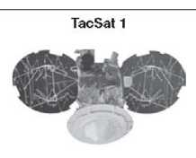 |
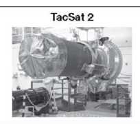 |
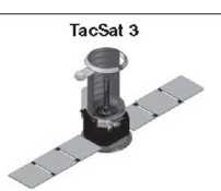 |
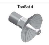 |
Tactical mission capabilities/requirements |
|||
| * Tactical radio frequency payloads and ultra-high-frequency cross-platform link * Low-resolution visible and infrared cameras * Payload scheduling and data access via the Secret Internet Protocol Routing Network |
* Common Data Link X-band radio to send data directly to theater * Tactical imaging and radio frequency * Science payloads * Payload scheduling and data access via the Secret Internet Protocol Routing Network |
* Hyperspectral imaging sensor for tactical targeting of camouflaged and hard-to-detect targets * Secondary space communications payload for data exfiltration/infiltration to warfighter |
* Mobile Data Communication services * Data relay from terrestrial sensors * Friendly forces tracking * Payload scheduling and data access via the Secret Internet Protocol Routing Network |
Mission selection process |
|||
| Mission selected based on knowledge of specific combatant command's need | Mission selected based on existing Air Force Research Laboratory demonstration satellite | Mission selected through Air Force Space Command formalized process | Mission selected through Air Force Space Command formalized process |
Primary developer and intended user |
|||
| Office of Force Transformation/Naval Research Laboratory for U.S. Pacific Command |
Air Force Research Laboratory for U.S. Strategic Command (sponsors include Air Force Research Laboratory, Director of Defense Research and Engineering, and a joint Advanced Concept Technology Demonstration) | Air Force Research Laboratory for U.S. Army Space and Missile Defense Command, U.S. Special Operations Command, and other combatant commands (sponsors include Air Force Research Laboratory, Office of Force Transformation, Army and Office of Naval Research) | Naval Research Laboratory for U. S. Strategic Command (Office of Force Transformation/Office of Naval Research satellite sponsors; Air Force launch sponsor) |
Source: Naval Research Laboratory and Air Force Research Laboratory
integrating the emitter identification capability for Maritime Domain Awareness (MDA) demonstrations.
TacSat-3, led by the AFRL, was to have an Air Force-provided hyperspectral imager as its primary payload and a Navy (ONR)-provided payload for two-way, Internet Protocol (IP)-based buoy communications. TacSat-3 was scheduled to launch in spring of 2009.
TacSat-4, led by ONR/NRL, was to provide ten ultra high frequency (UHF) channels for communications, data exfiltration, or Blue Force Tracking. The highly elliptical orbit would also augment geosynchronous communications by allowing near-global, but not continuous, coverage, including the high latitudes. Finally, TacSat-4 would also have the ONR payload for two-way, IP-based buoy communications. TacSat-4 was scheduled to launch in fall of 2009.
A jointly written plan for an ORS Office was submitted to Congress in April of 2007. In May 2007, STRATCOM approved the "Initial CONOPS for ORS," and on 17 May 2007, the DEPSECDEF officially established the ORS Office. In addition to the Congressional mandate for this office, the Chinese ASAT demonstration in January 2007 spurred the Executive Agent of Space, Dr. Ronald Sega, to secure approximately
--185--
$100 million per year for the office. As of early 2009, the ORS Office coordinated ORS activities, provided launch and Military Utility Analysis for the TacSats built by the S&T community, and had begun the first "ORS-1" satellite to augment an intelligence, surveillance and reconnaissance (ISR) need.
Navy Space Science and Technology in the Twenty-first Century
Prior to 2006 the majority of space science and technology (S&T) funded directly by the Office of Naval Research (ONR), and indirectly through the Naval Research Laboratory (NRL), consisted of basic research focused on understanding the sun, the upper atmosphere and ionosphere to help mitigate space weather impacts on DoD and Naval space systems. NRL space research funded from the ONR Base Program and heavily leveraged by NASA, developed spaceflight instruments to monitor explosive events on the sun and models of solar activity to develop a forecast capability for geomagnetic storms at the Earth. Ultraviolet remote sensing research from space led to the development of techniques for determination of upper atmospheric and ionospheric densities. These techniques were adopted by the Defense Meteorology Satellite Program (DMSP) and flown operationally as the Special Sensor Ultraviolet Limb Imager (SSULI) series of operational sensors.
In this same period ONR funded space research on the lower ionosphere focused on understanding terrestrial propagation of ELF/VLF waves to ensure 24/7 global communication with the submarine force. A spin-off of this research showed that these long wavelength waves could propagate through the ionosphere where they could lead to the depletion of high energy "killer electrons" in the magnetosphere. This discovery has spurred further research and several satellite programs to investigate the possibility of rapidly depleting the magnetosphere of high energy electrons in the event of a high altitude nuclear event to protect low earth orbiting (LEO) satellites. Additional ONR funded research, in partnership with NRL, led to the development of assimilation ionospheric models and transition to the Air Force Weather Agency to improve systems depending on propagation through the ionosphere. Additional research was directed to developing an ability to monitor and predict ionospheric scintillation that leads to outages of GPS navigation, HF communication and UHF SATCOM.
In 2006, following the successes in the TacSat program (see page 183), ONR established the Tactical Space Innovative Naval Prototype (INP) program to develop small, low-cost maritime payloads for flight on TacSats. The INP funded several maritime demonstration payloads, including UHF communications, blue force tracking, data exfiltration, maritime hyperspectral imaging, and tracking ships from space.
The Ocean Data Telemetry Microsatellite Link (ODTML) data exfiltration transceiver was launched from NASA's Wallops Flight Facility in Virginia in May 2009 on TacSat 3. Two more payloads were manifested for launch in 2010. The Hyperspectral Imager of the Coastal Ocean (H/CO) was launched to the International Space Station in September 2009. The Comm-X UHF payload, the primary payload on
--186--
TacSat 4 was scheduled for launch aboard a Minotaur 4 launch vehicle in late summer 2010.
In 2006, the Naval Center for Space Technology (NCST) successfully completed and operated a low-cost advanced propulsion spacecraft designed for the precision orbital transfer of small satellites. The Upper Stage launched on a Boeing Delta II from Cape Canaveral Air Force Station in June 2006 and completed the transfer and release of the small satellites.
The Upper Stage is a propulsion module that also functions as a standalone spacecraft. As such, it contains all hardware necessary for autonomous operations, including processing, software, RF communications, attitude determination/control and power. The Upper Stage provided the propulsion necessary to transfer two experimental small satellites from the Delta II and provided Geosynchronous Transfer Orbit (GTO) to the final geosynchronous orbit. The NCST engineering team completed integration of the Upper Stage with the small satellites, fueling of all vehicles, and integration with the launch vehicle. Once launched, NCST engineers operated the spacecraft from the NRL Blossom Point Mission Operations Center in southern Maryland.
In 2008, as a result of the success of the INP program, the Chief of Naval Research began investing in space science and technology across the Five Year Defense Program. Initial investments were targeted at developing an RF architecture with software programmable radios for inclusion in small satellites for maritime applications including synthetic aperture radar, satellite communications, and tactical electronic warfare.
--187--
[blank page]
--188--
EPILOGUE - NAVY SPACE IN 2009: A FIFTY YEAR RETROSPECTIVE
In 1959 the Vice Chief of Naval Operations signed out nine requirements for space capabilities to support the Navy. He noted that several of these requirements were shared by other Services and stated that Navy's policy would be to "participate fully in the development of [all those joint] operational requirements which have Naval applications," and to "support vigorously, by funding and otherwise, all of the operational requirements that are unique to Navy." What follows is a semicentennial report card noting the degree to which each of these nine requirements been fulfilled during the years after its promulgation.
NAVIGATION
1959 requirement: "develop a satellite system for providing accurate, all-weather, worldwide navigation for naval surface ships, aircraft, and submarines."
Fulfillment: Transit (page 24) was developed and demonstrated in 1961, became operational in that decade, and eventually had 60,000 users. It was superseded in the 1990s by GPS (page 89), which has many millions of civilian and military users.
Navy role: Navy conceived, developed, and fielded Transit. For the jointly acquired GPS, Navy developed enabling technology (page 43) and the GPS proof-of-principle satellites page 87).
RECONNAISSANCE/SURVEILLANCE
1959 requirement: "provide satellite reconnaissance/surveillance systems, with supporting equipments, to obtain continuous and up-to-date information not obtainable by other known systems on ocean and sea targets, air targets, and land targets of naval interest."
Fulfillment: Reconnaissance/surveillance satellites operated by the National Reconnaissance Office began collecting intelligence in the 1960s. Initially, information from these satellites was shared with the Navy only though highly classified channels. Beginning in the late 1960s, information on ocean and sea targets, air targets, and land targets of interest were disseminated to Navy commands and units afloat through the regional Fleet Ocean Surveillance Centers (page 57). In the 1980s capability was established for broadcasting near-real-time sea-, air-, and land contacts directly to all Navy units (page 123), and in the 1990s connectivity was implemented also for rapid dissemination of satellite reconnaissance imagery to the larger ships (page 152). The surveillance/reconnaissance coverage was global and continual (or continuous but not global), as limited by orbital mechanics and
--189--
an affordable number of satellites. The aircraft carriers and amphibious command ships were configured to receive rapid imagery as well as the real-time contact reports. By 2009, submarines and Navy combat-support aircraft were equipped to receive the near-real-time sea-, air-, and land contact reports, integrated into their respective combat direction and control systems, and Aegis ships assigned to tactical ballistic missile defense were similarly equipped to receive and utilize theater ballistic missile contact reports (pages 155, 174). Non-Aegis cruisers and destroyers were equipped to receive and display near-real-time contact reports, but these were not yet integrated into their combat direction and weapons control systems.
Navy Role: The Navy pioneered exploitation by the operating forces of the NRO surveillance satellites (page 57) and developed and fielded connectivity and equipment for reporting the surveillance contact reports directly to tactical forces in near-real-time (pages 92 and 123). Navy and joint efforts over the years to acquire radar satellites, to complement NRO's surveillance/reconnaissance capability, were not successful (pages 55, 99, and 122). The lack of an active space-based wide-area surveillance system covering the oceans of the world remains an impediment to achieving fully effective maritime domain awareness.
1959 requirement: "provide a system capable of obtaining weather information over areas [otherwise] void of meteorological observations, for the support of naval forces."
Fulfillment: Defense satellites and many civil satellites provided meterological information for Navy worldwide weather reporting and forecasting (pages 57 and 100).
Navy role: Navy's major ships were configured to receive satellite-derived meteorological data directly, beginning in 1975 (page 101).
1959 Requirement: "develop a system for obtaining and utilizing geodetic, geophysical, mapping, ice-reconnaissance, and sea-surface temperature environmental data."
Fulfillment: Satellites were used extensively for geodetic and geophysical measurements, mapping of sea-surface heights, wave heights, sea-surface temperatures, and other environmental data.
Navy role: The Applied Physics Laboratory conducted a major geodetic program during the 1960s to map the earth's shape and gravitational fields
--190--
affecting satellite orbits and missile trajectories. The Navy used satellite-borne altimeters for mapping sea-surface heights (pages 102 and 133). The Meterological and Oceanographic Command acquired a GEOSAT Follow-on (GFO) satellite and operated it from 1998 to 2008, providing data extending the Navy's mapping of ocean currents and fronts/eddies needed to support Navy's littoral operations (page 162). Navy orbited the Coriolis Windsat in 2003 to make oceanographic measurements (page 178).
1959 Requirement: "develop an anti-satellite weapon system, to be operable from fleet units and be immediately responsive to fleet requirements."
Fulfillment: Proposals by the Navy and other Services to develop submarine-, surface-ship-, and naval-aircraft-launched anti-satellite weapons were dropped in the early 1960s for polito-strategic reasons (page 67), and there was no development of direct-ascent anti-missile weapons by any of the U.S. military services until much later. After Soviet military policy in the early 1970s shifted away from global strategic warfare and toward planning for tactical warfare, including war at sea, U.S. Navy's concern turned to the potential threat from existing Soviet low-orbiting ocean reconnaissance satellites and proposed in 1978 to develop sea-based anti-satellite weapons, but little came of it (page 103). DoD then determined that development and launch of kinetic anti-satellite weapons were to be the sole responsibility of the Air Force; however, despite Navy's expressed concerns at the time, funds were not identified by the Air Force to develop any fleet-defense ASATs. Then with dissolution of the Soviet Union in the early 1990, that threat subsided, and the Navy's ASAT requirement with it (page 135).
Navy role: No Navy (or other U.S. military) program was undertaken to develop an anti-satellite weapon system. In the 1990s some Navy's Aegis ships were assigned the mission of ballistic missile defense and equipped for that purpose with the Standard Missile-3, designed to shoot theater ballistic missiles. In February 2008 an Aegis cruiser was ordered to shoot down an inactive low-orbiting U.S. satellite over the Pacific, and the cruiser acquired, tracked and destroyed the satellite, demonstrating the first U.S. anti-satellite weapon to be operable from fleet units (or from any U.S. platform, for that matter).
--191--
SEA-BASED MANNED INTERCEPTOR SPACECRAFT
1959 requirement: "develop sea-based, manned interceptor spacecraft to intercept enemy surveillance/reconnaissance and communications satellites and manned weapon-bearing 'trajectory' spacecraft posing threats to fleet units. (This requirement, stated in 1959, was apparently envisioned as an analogy to sea-based, manned interceptor aircraft that Navy uses to intercept enemy aircraft)
Fulfillment: No development of sea-based manned spacecraft of any kind ever ensued. (But see the sea-based unmanned anti-satellite capability, above.)
Navy role: Although the Navy provided many astronauts for NASA's manned spacecraft programs, no manned spacecraft had a military mission (page 63). The Navy did contribute technology to the Air Force's (military) Manned Orbiting Laboratory (MOL) program during the 1960s, but when the MOL Program was terminated in 1969, the Navy's participation ended with it (page 64).
FLEET LAUNCH AND CONTROL OF SATELLITES
1959 requirement: "develop equipment and techniques for the fleet to launch satellites with tactical payloads into orbit and control them in orbits and orientations for proper functioning of the payload."
Fulfillment: Until 2008, no program was undertaken to develop equipment or techniques for ships or submarines either to launch satellites or to control them on orbit. In 2008, an Operationally Responsive Space Office was established, under the Office of Force Transformation of the Secretary of Defense, to generate very small satellite payloads that can be placed quickly on orbit, and a series of small demonstration satellites called Tacsats was developed. The initial concept of operations, approved by the Strategic Command in 2008, called for launch of the TacSats by the Air Force from the continental U.S., rather than from ships or submarines, but with potential to place them under control on orbit by tactical forces (page 183).
Navy role: TacSat development was managed initially by NRL's Naval Center for Space Technology (and later transitioned to a joint program, with partipation by the Office of Naval Research).
ELECTRONIC INTELLIGENCE RECONNAISSANCE SATELITES
1959 requirement: "develop a satellite system capable of detecting, locating, and processing deliberate and inadvertent electronic emissions from foreign
--192--
nations, to be used for technical intelligence, strategic warning, and mission planning."
Fulfillment: Development of electronic intelligene (ELINT) satellites became subsumed, along with all other military surveillance/reconnaissance satellites, in the mission of the National Reconnaissance Office.
Navy role: The Navy developed and successfully flew the world's first electronic-intelligence reconnaissance satellites, in 1960 (page 30). (This program was turned over to the National Reconnaissance Office shortly after it was formed in 1962 (page 54).
1959 requirement: "provide satellite capability for Navy fixed point-to-point communications, communications among mobile units, communications between mobile units and shore facilities, and broadcast communications from shore to ships and submarines.
Fulfillment: With the environmental dependence and uncertainties of MF/HF radio, and anticipating loss of the Navy's worldwide network of shore-based communications stations in the 1970s, the Navy's need for long-haul communications became urgent (more critically so than the other Services, which had access to land lines and microwave relay towers). By the late 1970s, UHF satellite communications entirely replaced the former medium-and high-frequency (MF and HF) radio for long-haul secure voice, teletype, facsimile, and digital data communications, shore-to-shore, shore-to-ship (including the Fleet Broadcast), ship-to-shore, and ship-to-ship. SHF satellite communications antennas and equipment were installed in the major ships whose commanders needed the wider bandwidth for intelligence, weather, and high-level communications, and whose flagships could handle the large SHF antennas. In the 1990s, EHF satellite capability was added in the major ships for rapid delivery of imagery and other applications requiring the even greater bandwidth and
Navy role: The Navy participated in development of, and by operational urgency drove the schedule of, the Fleet Satellite Communications (FLTSATCOM) system (pages 78 and 116). Based on success in early acquisition satellite communications, including commercial leasing, the Navy was assigned to manage acquisition of UHF Follow-on (UFO) satellites (page 158) and later the Mobile User Objective System (MUOS) (page 175). In the late 1980s, the Navy flew EHF communications relay packages on UHF satellites to provide fleet and other users with interim EHF communications capability (page 162) until the joint Milstar systems became available in 1996. In the early 1990, the Navy conducted demonstrations of near-real-time delivery of satellite imagery via EHF that excited operators'
--193--
interest, with the result that all large combatant ships were fully equipped with EHF-SHF broadband capability (page 152).
In addition to the above requirements, promulgated in 1959, subsequent experience with space systems applications disclosed an important additional Navy need: "take steps to ensure system survivability for those space systems that are critical to Navy mission performance, so they remain available for use in combat despite losses or impairment from hostile or other events."
Fulfillment: In the 1960s during the Cold War with the Soviet Union, the Air Force designed and operated certain satellite systems to survive in wartime, including nuclear war. NRO's surveillance/reconnaissance satellites were initially designed to fulfill their function by the end of the precursor stage of nuclear war. In the 1970s and 1980s with Cold War concerns having shifted to possibility of conventional war, including war at sea with the Soviet Union, steps were taken to improve the survivability of some U.S. military satellite systems: improvements to the Navy's deployed Transit navigation systems (page 87); renegotiation of survivability requirements for the joint-services Milstar communications system under development (pages 85 and 117); and design of robustness into the Improved Surveillance System (page 121). In 1988 the Naval Space Command assembled a panel of Navy technical experts and flag officers to examine the survivability of U.S. space systems and the implications for Navy's tactical warfighting, and a program was initiated to brief the fleet on these findings (page 136).
Navy role: The Navy's Transit navigation system was designed to withstand nuclear war (page 41).
By 2009, the Navy had largely fulfilled its requirements for space as spelled out by the Chief of Naval Operations 50 years prior. In doing so, the Navy's global missions had become critically dependent on those space systems, processes, and organizations that were developed. The and evolution of those systems have become vital requirements for the Navy.
--194--
APPENDIX A PRINCIPAL SPONSORS OF SPACE AND SPACE-RELATED ACTIVITIES ON THE CNO STAFF
The offices and officers listed in this appendix were responsible, on behalf of the Chief of Naval Operations (CNO), for determining Navy operational requirements, identifying funding sources, programming, and budgeting the resources for space and space-related activities; evaluating the operational utility of these activities; and defending the respective space programs in budget competitions.
The following were the Navy's space sponsors on the CNO's staff in the early years.
Space Navigation (TRANSIT) Program
Submarine Warfare Division (OP31) under the Fleet Operations Deputate
Responsible for TRANSIT in the 1950s and 1960s.
Range Instrumentation Programs
Astronautics and Range Division (OP54) of the Naval Air Deputate
| RADM J. P. Monroe | 1962 |
Space Reconnaissance & Surveillance Program Director of Naval Intelligence
| RADM Laurence Frost* | 1959-1961 |
| RADM Vernon L. Lowrance* | 1962-1963 |
| RADM Rufus L. Taylor* | 1963-1966 |
| RADM Eugene B. Fluckey* | 1966-1968 |
| RADM Frederick J. Harlfinger* | 1968-1971 |
Air/Space Warfare Division of Naval Intelligence
| CAPT Lloyd Moffitt | 1969 |
As a result of RADM William Moran's discussions in 1969 with his old friend, then Chief of Naval Operations Admiral Thomas Moorer, sponsorship for space research activities (to which the Navy had been constrained by the 1961 DoD policy - see page 70) was established within the Navy Space Program (OP 76) of the Research and Development Directorate. In 1971, this became the Space and Command Support Division (OP 986) of the Research, Development, Test, and Evaluation Directorate (OP 098). Its space branches were surveillance; navigation and geodesy; meteorology (weather); and tactical communications.
Navy Space Program (OP 76) of the Research and Development Directorate (1969-1971)
Space and Command Support Division (OP 986) of the Research, Development, Test, and Evaluation Directorate (OP 098) (1971-1989)
| RADM William J. Moran | 1969-1970 |
| RADM Horace H. Epes | 1970-1971 |
| RADM Lloyd W. Moffitt | 1971-1974 |
| RADM Robert K. Geiger | 1975-1975 |
| CAPT Robert T. Darcy | 1976-1977 |
| RADM Grover M. Yowell | 1977-1978 |
| CAPT Kenneth R. Haas | 1979-1982 |
| CAPT John R. Seeholtz | 1983-1984 |
* Double-hatted as NRO Director of Program C. (Later, beginning in 1972, Navy systems acquisition directors, rather than program sponsors, were double-hatted as Program C Directors; see Appendix B
--195--
| CAPT T. E. Stone | 1984-1985 |
| CAPT J. C. Kranz | 1985-1987 |
| CDR James A. Carlson | 1988-1989 |
To direct the programming of funds for Navy (and joint) space systems transitioning from research and exploratory development into further development and procurement, the following additional structure was established in the Command and Support Directorate (OP 094):
| CAPT S. L. Gravely* Coordinator of Navy Satellite Communications Program (OP 094E) | 1969-1970 |
| RADM Lloyd Moffitt Coordinator of Satellite Programs (OP 094W) | 1971-1974 |
From 1974 to 1979, the OPNAV space functions under OP 094 were divided between the Command and Support Directorate (OP 094) and the Antisubmarine Warfare and Ocean Surveillance Directorate (OP 095).
Coordinator of Navigation and Communications Satellites (OP 094W until 1975, then OP 941)
| CAPT Samuel B. Wilson | 1974-1975 |
| CAPT R. E. Enright | 1976-1978 |
Ocean Surveillance Division (OP 0945)
| RADM R. D. Snyder | 1979-1980 |
Ocean Surveillance Division (OP 951)
| RADM R. J. Early | 1974-1975 |
| RADM R. D. Snyder | 1976-1978 |
(To OP 0945 in 1979)
Responding to the recommendations of a sequence of annual meetings of the Space Panel of the Naval Studies Board, Navy space advocates began seeking to have a "home" established on the OpNav staff, with flag authority to act as a single focal point of advocacy and sponsorship for space matters. In 1979, as an interim step, RADM Snyder's OP 951 Division was redesignated as OP 945 and placed, along with OP 941, under OP 94. A more permanent solution arrived in 1981, when all OpNav responsibility for space and space-related matters (other than research and technology) was consolidated into a newly created division on the staff of the CNO, called the Navy Space Systems Division, under a flag officer, with four branches: Navy satellite communications; navigation and environmental satellites; Navy Tactical Exploitation of National Capabilities (TENCAP); and ocean surveillance (each listed separately below). From 1981-1993, this division was under the Command, Control, and Communications Directorate (OP 094). In 1993, when the Office of the CNO was significantly reorganized, this division was redesignated as N63 and placed under the Director of Space and Electronic Warfare (N6). In 1995, it became simply the Navy Space Division, still under the N6 Directorate.
___________
* Double-hatted as chief of OP 764.
--196--
Navy Space Systems Division (OP 943) of the C3 Directorate (OP 094) (1981-1993)
Navy Space Systems Division (N63) of the Space and Electronic Warfare Directorate (N6) (1993-1999)
| RADM William E. Ramsey | 1981-1985 |
| RADM D. Bruce Cargill | 1985-1986 |
| RADM D. V. Becker | 1987-1988 |
| CAPT Phillip S. Anselmo | 1988-1989 |
| CAPT F. H. Hauk | 1989-1990 |
| CAPT E. R. Enterline | 1991-1995 |
| CAPT D. Thompson | 1996-1998 |
Navy Satellite Communications (OP 0943C) 1981-1993
Navy Satellite Communications (N631) 1993-1999
| CAPT William B. Pierce | 1981-1982 |
| CAPT Arthur E. Rowe | 1982-1983 |
| CAPT H. M. Walters | 1983-1984 |
| CAPT T. N. Danner | 1985-1988 |
| CAPT Joseph Daughtry | 1989-1990 |
| CAPT W. C. Clair | 1991-1992 |
| CDR A. W. Boyd | 1993-1995 |
| CAPT R. Leininger | 1997-1999 |
(To N61 in 2000)
Navigation and Environmental Satellites (OP 0943D) 1981-1992
| CAPT Robert J. Munn | 1981-1985 |
| CDR Robert A. Engle | 1986-1987 |
| CAPT J. B. Hodge | 1988-1990 |
| CAPT G. A. Barrett | 1991-1992 |
(Combined with N633 in 1992)
Navy TENCAP (OP 0943E) 1981-1993
Navy TENCAP (N632) 1993-2009
| CAPT W. D. Holsten | 1980-1981 |
| CAPT Phillip N. Edson | 1981-1982 |
| CAPT Kent B. Pelot | 1983-1986 |
| CAPT Frank J. Zak | 1986-1989 |
| CAPT Lawrence Clark | 1989-1991 |
| CAPT Robert W. Stoddard | 1992-1994 |
| CAPT Allan W. Legrow | 1994-1998 |
| CAPT Edward Abbot | 1999-2000 |
| CAPT Robert Huddleston | 2001-2002 |
| CDR Maria Lyles | 2003-2003 |
| Ms. Rosemary Wenchel | 2003-2005 |
| CAPT W. J. Campbell | 2006-2007 |
| CAPT Joseph Cheneler | 2007-2009 |
Ocean Surveillance Satellites (OP 0943F) 1981-1993
Ocean Surveillance and Navigation Satellites (N633) 1993-2002
| CAPT Thomas C. Adams | 1981-1982 |
| CAPT Henry L. Phillips | 1982-1982 |
| CAPT Taylor H. Meese | 1982-1984 |
| CAPT James N. Mahood | 1985-1986 |
| CAPT E. Benford | 1986-1986 |
| CAPT Gary McDowell | 1987-1989 |
| CAPT Thomas Herting | 1990-1991 |
| CAPT J. G. Ross | 1991-1991 |
| CAPT T. S. Eseman | 1992-1992 |
| LCDR J. M. Burton (acting) | 1993-1993 |
| CAPT E. Wallace | 1994-1994 |
| CAPT D. Riffle | 1994-1995 |
| LCDR M. Sturges | 1995-1995 |
| CAPT M. Crawford | 1996-1998 |
| CDR M. Copolof | 1999-2002 |
--197--
In 2000, a deputy directorate for Space Information (N612) was established in the Information Transfer Division (N61) of the CNO's Space and Electronic Warfare Directorate (N6). This office sponsored the Navy's EHF/UHF communications satellite, SHF communications satellite, commercial satellite, and advanced satellite programs.
| CAPT R. Leininger | 2000-2001 |
| CDR T. Pinto-Sassman | 2001-2002 |
While N6/7 was amalgamated from 2003 to 2009, space systems sponsorship by OPNAV did not appear explicitly in that structure. (In 2009, N6 and N2 functions were combined to form the Information Dominance Directorate (N2/N6), and space sponsorship was placed under a two-star Division Director, N2/N6E.)
--198--
APPENDIX B PRINCIPAL NAVY SPACE SYSTEMS ACQUISITION DIRECTORS AND MANAGERS
Over the span of this chronicle, responsibility for development and acquisition of the Navy's space systems development and acquisition activity was based at one time or another in the following Navy systems commands:
- Bureau of Ships (BUSHIPS): renamed the Naval Ships Systems Command (NAVSHIPS) in 1966 (and combined with the Naval Ordnance Systems Command in 1974 to form the Naval Sea Systems Command (NAVSEA)).
- Bureau of Naval Weapons (BUWEPS), which in 1966 split into the Naval Air Systems Command (NAVAIR) and the Naval Ordnance Systems Command (NAVORD).
- Naval Electronic Systems Command (NAVELEX): established in 1966, renamed the Space and Naval Warfare Command (SPAWAR) in 1985.
- Naval Material Command (NAVMAT): established in 1966 under the Chief of Naval Material; disestablished in 1985.
The following were the principal offices responsible for developing and acquiring Navy space systems (and the Navy's work with other Services on joint space systems) prior to 1966, with their respective leaders.
Satellite Communications and Astronautics Programs of the Warfare Systems Division Assistant Chief of Staff of
BUSHIPS for Research and Development
| LCDR Burton I. Edelson | 1961-1962 |
| CDR Keith N. Sargent | 1963-1963 |
| Mr. L. E. Johnson | 1964-1964 |
(To NAVAIR 538 in 1964)
ADVENT Program Manager
Assistant Chief of Staff of BUSHIPS for Research and Development
(Satellite communications terminals for Navy ships)
| CAPT Paul C. Combs | 1961-1962 |
(Missile) Range Programs, Bureau of Naval Weapons
(included range ships development and operations, as well as satellite range operations and instrumentation)
| CAPT Joseph J. Pace | 1962-1964 |
| Mr. Frederick J. Hall | 1965-1966 |
(To NAVMAT PM-5, in 1966)
Range and Astronautics Division
| CAPT Harry D. Helfrich, Jr | 1962-1963 |
(To PM 5, NAVMAT, in 1966)
--199--
Astronautic Programs, Bureau of Naval Weapons
(including TRANSIT program; geodedic, weather, and surface-surveillance satellites; space surveillance (from the ground); and astro-defense
| CAPT Robert F. Freitag | 1960-1963 |
| CAPT William T. OBryant | 1964-1965 |
| CAPT C. C. Andrews | 1965-1966 |
(To NAVAIR 538 in 1966)
In March 1966, as part of a major reorganization, the Navy placed all of its material support commands under the newly appointed Chief of Naval Material, who reported to the Chief of Naval Operations. Shortly thereafter, in June 1966, the Naval Electronic Systems Command (NAVELEX) stood up, assuming the functions of the electronic divisions of three of the former Bureaus. Initially, the Navy's space activities could be found in NAVSHIPS, NAVWEPS, and NAVELEX, as well as under Program Managers (PM 5 and PM 16) directly under the Chief of Naval Material. NAVMAT provided designated program managers that spanned across these systems commands and that required a degree of independence in their operations. By 1974, however, all of these Navy space programs had been placed in NAVELEX.
Astronautics Division (NAVAIR 538), Naval Air Systems Command (1966-1971)
(Branches: Navigation/TRANSIT, Geodedic, Weather, and Surface-surveillance Satellites; Space Surveillance (from the ground); and Astro-defense
Space Systems Division, Naval Air Systems Command (1971-1973)
(Branches: Satellite Communications, Satellite Navigation, and Satellite Observations (environmental)
| CAPT J. N. Miller | 1967-1968 |
| CAPT C. B. Crockett, Jr | 1969-1969 |
| CAPT John T. Geary | 1970-1972 |
(To NAVMAT PM 16 in 1973)
Instrumentation Ships Program (PM 5), NAVMAT
| CAPT Alex F. Hancock | 1966-1967 |
| CAPT Earl B. Fowler | 1968-1968 |
(To NAVSHIPS in 1969)
Satellite Communications (PME 116), NAVELEX
| CAPT Merton D. Van Orden | 1967-1969 |
| CAPT H. H. Felt | 1969-1973 |
(To NAVELEX PM 106-1 in 1974)
Navy Space Project Office (PM 16), NAVMAT
| RADM Robert K. Geiger | 1971-1974 |
(To NAVELEX PME 106 in 1974)
--200--
Navy Space Projects Office (PME 106), NAVELEX
(Branches: Navy satellite communications; navigation systems; environmental satellites; and special and advanced system projects, each of which is listed separately below)
| RADM Robert K. Geiger | 1974-1975 |
| CAPT Robert T. Darcy | 1976-1977 |
| RADM Grover Yowell | 1977-1980 |
| CAPT LeRoy Patterson | 1980-1982 |
| COMO Dennis Brooks | 1982-1985 |
(To SPAWAR 004 and PD40 in 1985)
DoD Space Programs
Satellite Communications (PME 106-1)
| CAPT C. E. Reid | 1974-1974 |
| CAPT John W. Pope | 1975-1978 |
| CAPT John Newell | 1978-1983 |
| CAPT F. F. Mackenzie | 1984-1985 |
(To PME 142-1 in 1985)
Navy Project Manager, Navigation Systems/NAVSTAR/GPS
(PME 106-2)
| CDR J. R. Tuttle | 1973-1973 |
| LCDR J. P. McGahan | 1974-1974 |
| Mr. Guy Burke | 1974-1982 |
| CDR K. D. Aanerud | 1983-1984 |
| CAPT William Boissenin | 1984-1985 |
MILSTAR Joint Project
| CAPT Robert C. Bates | 1984-1985 |
Environmental Satellites
(PME 106-3)
| Mr. Duane G. Robbins | 1975-1980 |
Aerospace Ocean Surveillance
(PME 106-6)
| CAPT Leon Wardle | 1983-1985 |
National Space Programs
Advanced Systems
(PME 106-4)
| CAPT Gordon Jayne | 1973-1975 |
| CAPT Dennis Glover | 1976-1980 |
| CDR William Kendrick | 1981-1984 |
| CAPT Vernon C. Block | 1984-1985 |
Special Project Office
(PME 106-5)
| CAPT Grant Haggquist | 1974-1976 |
| CAPT Frank Quigley | 1976-1979 |
| CAPT/COMO Thomas Betterton | 1979-1986 |
(To SPAWAR 004-5 in 1985)
In 1985, NAVELEX was redesignated as the Space and Naval Warfare Command (SPAWAR), at which time the above space-system management functions were divided between two offices within SPAWAR: Director of Space and Sensor Programs, overseeing DoD space programs, and the Assistant SPAWAR Commander for Space Technology, managing Navy's participation in National space programs. Each was headed initially by a flag officer. In 1990, the Navy created the Program Executive Office for Space Communication and Sensor Systems (PEO-SCS), and the programs of the SPAWAR Space and Sensor Program directorate were transferred to PEO-SCS. After 1992, the Assistant Commander for Space Technology became the Director of Space Technology (SPAWAR 40).
--201--
DoD Space Programs
SPAWAR Space and Sensor Programs (PD 40)
| RADM Thomas K. Mattlingly | 1985-1989 |
| RADM D. Eaton | 1989-1990 |
| Dr. Frank R. Diederich | 1991-1992 |
Space Systems Program (PMW 142)
| Dr. Frank R. Diederich | 1985-1988 |
| CAPT William Norris | 1988-1989 |
| CAPT C. Thomson | 1989-1992 |
Satellite Communications (PMW 142-1)
| CAPT F. Mackenzie | 1985-1986 |
| (Vacant) | 1987 |
| CDR J. Jaudon | 1988-1988 |
| LCDR N. Brownsberger | 1989-1990 |
NROSS Satellite Program (PMW 142-7)
| CAPT N. Holben | 1986 |
Program Executive Officer for Space Communication and Sensor Systems (PEO-SCS)
| RADM L. E. Blose | 1990-1991 |
| John DeSalme | 1992-1998 |
| Mr. Bill Eaton | 1998-1999 |
Communications Satellite Program Office (PMW 146)
| Mr. Richard W. Hoffman | 1993-1995 |
| CAPT James Loiselle | 1995-2000 |
(continued under PD-14/PEO-SS)
National Space Programs
Asst SPAWAR Commander for Space Technology (SPAWAR 004) SPAWAR Director of Space Technology (SPAWAR 40) (after 1992)
| RADM Thomas Betterton | 1985-1992 |
| RADM Jay W. Sprague | 1993-1994 |
| CAPT Delio Lopez | 1994-1995 |
| CAPT Dwight Denson | 1995-1999 |
Special Project Office (SPAWAR 004-5)
| CAPT Arthur Collier | 1986-1990 |
| CAPT Delio Lopez | 1991-1994 |
(Disestablished as a Navy office and functions transferred to National programs in 1993)
Advanced Development (SBR-IR) (SPAWAR 004-4)
| CAPT Albert Skroch | 1986-1990 |
| CAPT George Mitschang | 1991-1992 |
In 1999, the PEO-SCS was disestablished, and all of the Navy's space acquisition functions were consolidated under a single flag officer triple-hatted in the Space and Naval Warfare Systems Command (see page 144). In 2004, these programs came under the newly created Program Executive Office for Space Systems (PEO-SS).
--202--
Space Technology Systems Program Office (SPAWAR PD 14) 1999-2004
Program Executive Office for Space Systems (PEO-SS) 2004-
| CAPT Dwight Denson | 1999 |
| RDML Rand Fisher | 2000-2004 |
| RDML Victor See | 2004-2008 |
| RDML Liz Young | 2008-2009 |
Communications Satellite Program Office (PMW 146)
(continued)
| Mr. Robert E. Tarleton | 2000-2004 |
| CAPT David Porter | 2004-2007 |
| Mr. Wayne Curles | 2007-2009 |
(To SPAWAR Space Field Activity)
--203--
[blank page]
--204--
APPENDIX C NAVY SPACE LEADERSHIP IN THE OFFICE OF THE SECRETARY OF THE NAVY
The following offices within the Office of the Secretary of the Navy (that is, not within the Span of control of the Chief of Naval Operations) were also involved in fostering and promoting space in support of Navy and Marine Corps operations.
Deputy Assistant Secretary of the Navy (DASN) for Space Technology
| Dr. Herbert Rabin | 1980-1984 |
Deputy Assistant Secretary of the Navy (RD&A) for C3I and Space Programs (1984-1990)
Deputy Assistant Secretary of the Navy (RD&A) for C4I, EW, and Space Programs (1991-2003)
Deputy Assistant Secretary of the Navy (RD&A) for C4I and Space Programs (2004- )
| Harold Kitson, Jr | 1984-1985* |
| Dr. E. Ann Berman | 1986-1988 |
| Dr. Robert Lefande (acting) | 1989 |
| RADM Brent M. Bennitt (acting) | 1990 |
| Dr. Edward C. Whitman | 1991-1993 |
| Dr. Marvin Langston | 1995-1997 |
| Dr. Ann Miller | 1998-1999 |
| Dr. Dale Uhler | 1999-2003 |
| RDML Michael Sharp (acting) | 2004 |
| Dr. Gary Federici | 2005-2010 |
During the 1990s, the Navy, in response to Congressional direction, began the process of appointing a Program Executive Officer (PEO) for each of its major acquisition programs in its several systems commands. Thenceforth, each PEO reported directly to the Assistant Secretary of the Navy for Research, Development, and Acquisition.
The Navy's PEOs for space systems were the PEO for Space Communication and Sensor Systems (PEO-SCS), responsible for the "white world" programs formerly under SPAWAR PD 40, from 1990 to 1999, and the PEO for Space Systems (PEO-SS), responsible for the acquisition of all Navy space systems beginning in 2004. The PEOs, as well as their major subordinate program offices, are listed in Appendix B.
* Mr. Kitson was appointed the DASN (RD&A) for C3I in 1982. His title changed in 1984 to DASN (RD&A) for C3I and Space when the DASN for Space Technology was disestablished after Dr. Rabin stepped down.
--205--
[blank page]
--206--
APPENDIX D COMMANDERS OF NAVAL SPACE COMMAND
The Naval Space Command was established on 1 October 1985 and was designated the Naval component of US Space Command. The command was disestablished and its billets transferred to the Naval Network and Space Operations command (which later became the Naval Network Warfare Command) in 2002.
Commanders of Naval Space Command
| Rear Admiral Richard H. Truly | Oct 1985 - Feb 1986 |
| Rear Admiral D. Bruce Cargill | Feb 1986 - Sep 1986 |
| Rear Admiral Richard C. Macke | Oct 1986 - Mar 1988 |
| Rear Admiral David E. Frost | Mar 1988 - Apr 1990 |
| Colonel Charles R. Geiger, USMC | Apr 1990 - May 1990 |
| Rear Admiral L. E. Allen, Jr | May 1990- Aug 1991 |
| Rear Admiral Herbert A. Browne, Jr | Aug 1991 - Oct 1993 |
| Rear Admiral Leonard N. Oden | Oct 1993 - Jan 1994 |
| Rear Admiral Lyle G. Bien | Jan 1994 - Dec 1994 |
| Rear Admiral Phillip S. Anselmo | Dec 1994 - Apr 1995 |
| Rear Admiral Katharine L. Laughton | Apr 1995 - Feb 1997 |
| Rear Admiral Patrick D. Moneymaker | Mar 1997 - Sep 1998 |
| Rear Admiral Thomas E. Zelibor | Sep 1998 - Jun 2000 |
| Rear Admiral J. J. Quinn | Jun 2000 - Mar 2001 |
| Rear Admiral Richard J. Mauldin | Apr 2001 - Dec 2001 |
| Rear Admiral John Cryer | Dec 2001 - Jul 2002 |
--207--
[blank page]
--208--
APPENDIX E NAVY RESEARCH LABORATORIES AND FACILITIES
From the beginning, research and development of space technology has been an essential part of the Navy's space activities. Three organizations have been prominent in this area: the Naval Research Laboratory (NRL); the Johns Hopkins University Applied Physics Laboratory (APL); and the Naval Electronics Laboratory and its successor organizations. The following is a list of key organizational elements and leadership in the Navy's development of space technology.
Naval Research Laboratory
| Mr. Howard O. Lorenzen Radio Division Superintendent | 1943-1980 |
| Mr. Reid D. Mayo Branch Head in Radio Division | 1943-1990 |
| Mr. Vincent Rose Section Head in Radio Division | 1950-2000 |
| Mr. Martin J. Votaw Branch Head, Satellite Techniques Branch | 1947-1963 |
| Mr. Edgar E. Dix Branch Head, Satellite Techniques Branch | 1955-1965 |
| Mr. Peter G. Wilhelm Director, Naval Center for Space Technology | 1959- |
| Mr. Robert E. Eisenhauer Superintendent, Space Systems Development Department | 1962-2008 |
| Mr. Robert T. Beal Superintendent, Spacecraft Engineering Department | 1962-1993 |
| Mr. Lee M. Hammarstrom Superintendent, Space Systems Technology Department | 1967-2002 |
| Mr. Frederick V. Hellrich Associate Director, Naval Center for Space Technology | 1967-2006 |
| Mr. Roger Easton Head, Space Applications Branch | 1943-1980 |
| Dr. Herbert Friedman Superintendent, Space Science Division | 1945-1990 |
| Dr. Herbert Gursky Superintendent, Space Science Division | 1990-2005 |
| Dr. Jill Dahlberg Superintendent, Space Science Division | 2006- |
Johns Hopkins University Applied Physics Laboratory
Dr. Frank T. McClure, Dr. William H. Guier, and George C. Weiffenbach, in March 1958 made the first measurements on the Soviet Union's Sputnik and originated the U.S. Navy's Transit space navigation concept (see page 24.)
JHU/APL Space Development Division (1959-1969)
JHU/APL Space Department (1969-)
| Dr. Richard Kershner Division/Department Head | 1959-1978 |
(Managed development of Transit Navigation System 1959-1969)
| Mr. Theodore Wyatt Transit Project Engineer | 1960-1969 |
Transit Program Manager
| Dr. John Dassoulas | 1969-1976 |
| Mr. Robert Danchik | 1976-1991 |
| Mr. Lee Pryor | 1991-1995 |
--209--
JHU/APL Fleet Systems Department
| Mr. H. Gregory Tornatore Navy Space Communications Program Area Manager | 1985-2001 |
| Mr. Samuel B. Wilson Naval Space Surveillance Systems Program Manager | 1985-1995 |
The U.S. Navy Radio and Sound Laboratory (NRSL), was established in 1940 in San Diego. It became the U.S. Navy Electronics Laboratory (NEL) in 1945; the Naval Command, Control, and Communications Laboratory Center (NCCCLC) in 1967, and the Naval Electronics Laboratory Center (NELC) later in 1967. In 1977, NELC merged with the Naval Undersea Center (NUC) to form the Naval Ocean Systems Center (NOSC). In 1992, NOSC absorbed several other organizations to become the Naval Command, Control, and Ocean Surveillance Center (NCCOSC) RDT&E Division, or NRAD. NRAD became the SPAWAR Systems Center (SSC) San Diego in 1997, and SSC Pacific in 2008.
NELC Satellite Systems Program Office (Code 1400)
| R. E. Shutters | (through 1977) |
NELC LOS and Satellite Communications Div (Code 2400)
| Frank M. Tirpak | (through 1977) |
NOSC Aerospace Systems Div (Code 815)
Communications Department
| H. J. Wirth | 1977-1983 |
NOSC Space Systems Division (Code 84)
Communications Department
| Dr. Marlan S. Kvigne | 1984-1992 |
NRaD Satellite Communications Division (Code 84)
Communications Department
| Carl Gibbens | 1992-1995 |
| Donald O. Milstead | 1995-1997 |
SSC San Diego Satellite Communications Div (Code 284)
Communication and Information Systems Department
| Donald O. Milstead | 1997-2005 |
NOSC Surface/Aerospace Surveillance Dept (Code 73)
| R. E. Shutters | 1977-1983 |
NOSC Space Systems & Technology Division (Code 76)
Surveillance Department
| R. E. Shutters | 1984-1986 |
| Ken Regan | 1987-1990 |
| Frank M. Tirpak | 1991-1992 |
NRaD Space Systems and Technology Div (Code 76)
Surveillance Department
| James Wangler | 1992-1997 |
SSC San Diego Joint & National Systems Div (Code 273)
Surveillance Department
| Tom Knight | 1997-2002 |
| Pat M. Sullivan | 2002-2006 |
| Diana Holifield | 2006-2008 |
--210--
SSC San Diego RF Communications Div (Code 552)
Communications and Network Department
| James Parsons | 2005-2007 |
SSC Pacific RF Communications Div (Code 552)
Communications and Network Department
| James Parsons | 2008- |
SSC Pacific Joint & National Systems Div (Code 273)
Surveillance Department
| Diana Holifield | 2008- |
--211--
[blank page]
--212--
APPENDIX F KEY CONTRIBUTORS TO NATIONAL SYSTEM DIRECT-BROADCAST CONCEPT AND CAPABILITY
The following people were key contributors to the concept and capability of delivering real-time contact reports from national sensor systems directly to tactical forces.
Navy Captain Bill Smith, Naval Electronic Systems Command: conceived the "sensor-to-shooter" approach; organized and directed Navy's OTH detection, classification, and targeting effort.
The Honorable David E. Mann, Assistant Secretary of the Navy (Research, Engineering, and Systems), swayed a skeptical Naval Intelligence Community to endorse and forward the original operational requirements approved by OP 095 for national satellite surveillance data in direct support of Navy tactical operations.
Navy Captain Al Best, and later Commander Pat Hanson, Joint Cruise Missile Project Office: promoted and implemented incorporation of near-real-time data from National systems into Tomahawk targeting.
Navy Captain Denny Glover, Naval Electronic Systems Command: designed near-real-time contact reporting into space-based radar (not procured); demonstrated sailors' ability to use the satellite data for convincing Navy leadership on the "sensor-to-shooter" concept.
Mr. Tom Boyd, USN (retired), Navy Special Projects Office: conceived and designed the TADIXS-B and TRAP format; directed design of the space segment of the Improved Surveillance System.
Navy Captain Fenton Carey, Navy Special Projects Office: strongly promoted and sold the direct tactical broadcast concept to Navy senior leadership.
Air Force Colonel Ron Knecht, Air Force TENCAP Office: led the successful effort by the joint TADIXS-B Working Group to oppose the Intelligence Community's attempts to put the direct tactical broadcasts under authority of the National Security Agency rather than the joint military services.
Mr. Lee Hammarstrom, Naval Research Laboratory: insisted that the original design of the ocean surveillance system have specific capability for tactical surveillance and targeting needs.
Naval Reserve Captain Dr. Bob Hess, consultant to Navy Special Projects Office: defined Navy tactical needs for National sensor systems to provide "sensor-to-shooter" inputs; coordinated review and approval by Navy CINCs; provided long-term concept continuity.
Mr. Jim Wangler, Navy Ocean Systems Center: engineered and implemented the communications connectivities to support the TADIXS-B simulations for
--213--
exercises and the TRAP Broadcast.
Mr. Alan Keimig, consultant to the Joint Cruise Missile Office, engineered the TADIXS-B and TRAP interfaces with Tomahawk weapons controllers.
Mr. Tom Knight, Navy Ocean Systems Center: designed the Tactical Receive Equipment (TRE) to meet special needs of ships, submarines, ground units.
Mr. Carl Gibbens and Henry Gok, Navy Ocean Systems Center: adapted TREs for installations in carriers, cruisers, battleship, and submarines and for tactical ground users.
Retired Navy Commander Gerry Brown, Naval Space Command: successfully promoted "sensor-to-shooter" demonstrations with tactical commanders; orchestrated exercises.
Navy Commander Mike Ketron, Naval Security Group: leading participant in the fleet OTH targeting working group; initiated transformation of the simulated TADIXS-B Broadcast into the permanent operational broadcast (TRAP) and was instrumental in coordinating its implementation.
Naval Reserve Captain Randy Nees, consultant to the Navy Special Projects Office: promoted development and acquisition of tactical receive equipment for Navy and other aircraft; as an aviator, demonstrated their effectiveness in operational exercises.
Retired Navy Commander Fred Glaeser, consultant to Navy TENCAP: wrote the plans to demonstrate tactical value of National and other sensors in fleet and joint exercises; pioneered new sources of surveillance and reconnaissance on the TRAP Broadcast.
Navy Captain John Newell: discovered the modulation technique employed for the first TRAP Broadcast, and engineered subsequent versions.
Navy Lieutenant Commander Jim Helm: Naval Space Command, supervised tests proving feasibility of the TRAP Broadcast.
Navy Captain Kent Pelot, USN (Director of Navy TENCAP, later consultant to the Navy Special Projects Office and the NRO): advocated the sensor-to-shooter concept in high-level policy papers and briefings.
Dr. Gary Federici, Center for Naval Analyses (now CNA Corporation): directed analyses of "sensor-to-shooter" exercises and operations; advised senior Navy leadership on the significance and implications of results.
--214--
APPENDIX G NRO SPACE PIONEERS
The following Navy personnel have been officially recognized as "Space Pioneers" by the National Reconnaissance Office.
Robert Eisenhauer: pioneered techniques enabling precise time-of-arrival signal recovery for intelligence satellites.
Lee Hammarstrom: conceived and integrated a major Program C satellite system; later served as NRO's Chief Scientist.
Fred Hellrich: pioneered the architecture, design, development, and deployment of computer processing for a major Program C satellite system.
Howard Lorenzen: advocated and directed development of the nation's first electronic intelligence satellite and subsequently led Navy teams in developing far more technically sophisticated satellite systems.
Reid Mayo: conceived and designed the nation's first electronic intelligence satellite.
Jim Morgan: Navy champion of electronic intelligence satellite support to military operations, developed the tasking and dissemination architecture for Program C systems.
Vince Rose: designed the receivers for early and subsequent Program C satellite systems.
Pete Wilhelm: developed multiple-launch dispensers, orbital insertion and maneuver techniques, and long-life and low-cost high-performance satellites; served as chief spacecraft engineer of the Naval Space Technology Center.
--215--
[blank page]
--216--
APPENDIX H LIST OF ACRONYMS
| ABM | Anti-Ballistic Missile |
| ACS | Afloat Correlation System |
| ADFC | Altimeter Data Fusion Center |
| AEHF | Advanced Extremely High Frequency |
| AFRL | Air Force Research Laboratory |
| AFSATCOM | Air Force Satellite Communications |
| AFSPC | The Air Force Space Command |
| AGF | Miscellaneous command ship |
| AGI | Advanced Geo-Spatial Intelligence |
| AIP | Anti-surface warfare Improvement Program |
| AIS | Advanced Information Systems |
| ANNA | Army, Navy, NASA, and Air Force |
| AoA | Analysis of Alternatives |
| APL | Applied Physics Laboratory |
| ARIES | Airborne Reconnaissance Integrated Electronic System |
| ARPA | Advanced Research Projects Agency |
| ASAT | Anti-Satellite |
| ASCC | Alternate Space Control Center |
| ASD(I) | Assistant Secretary of Defense (Intelligence) |
| ASMD | Anti Strategic Missile Defense |
| ASN | Assistant Secretary of the Navy |
| ASPADOC | Alternate Space Defense Operations Center |
| ASPO | Army Space Program Office |
| ASW | Anti-Submarine Warfare |
| ASWOC | Anit-Submarine Warfare Operations Center |
| AT&L | Acquisition, Technology & Logistics |
| ATP | Advanced Tracking Prototype |
| ATS | Applications Technology Satellite |
| AWS | Aegis Weapon System |
| BMD | Ballistic Missile Defense |
| BMDO | Ballistic Missile Defense Organization |
| BP | Blossom Point (NRL Mission Operations Center) |
| C3I | Control, Communications and Intelligence |
| C4 ISR | Command-and-Control, Communications, Computers, Intelligence, Surveillance and Reconnaissance |
| CAPT | Captain |
| CART | Control and Alert Reporting Terminal |
| CASREP | Casualty Report |
| CAWP | Collection Awareness Web Portal |
| CCAFS | Cape Canaveral Air Force Station |
| CCS | Combat Control System (submarines) |
--217--
| CDD | Capabilities Description Document |
| CDR | Commander |
| CG | Guided Missile Cruiser |
| CIA | Central Intelligence Agency |
| CIC | Combat Information Center |
| CINC | Commander-in-Chief |
| CINCPAC | Commander-in-Chief, U.S. Pacific Command |
| CINCPACFLT | Commander in Chief, US Pacific Fleet |
| CMA | Comprehensive Maritime Awareness |
| CMIS | Conical Microwave Imager/Sounder |
| CMR | Communications Moon Relay |
| CNA | Center for Naval Analyses (now CNA Corporation) |
| CNO | Chief of Naval Operations |
| CNR | Chief of Naval Research |
| COMIREX | Committee on Imagery Requirements & Exploitation |
| COMO | Commodore |
| COMOPTEVFOR | Commander of the Navy's Operational Test and Evaluation Force |
| Comsat | Communications Satellite Corporation |
| COMSIXTHFLT | Commander, U.S. Sixth Fleet |
| CTT | Command Tactical Terminal |
| CUDIXS | Common User Digital Information Exchange Subsystem |
| CWSP | Commercial Wideband Satellite Communications |
| DARPA | Defense Advanced Research Projects Agency |
| DBS | Direct Broadcast Service |
| DCA | Defense Communications Agency |
| DCGS-N | Distributed Common Ground System-Navy |
| DCNO | Deputy Chief of Naval Operations |
| DCS | Defense Communications System |
| DDG | Guided Missile Destroyer |
| DDR&E | Director of Defense Research and Engineering; Deputy Director of Research and Engineering |
| DFP | Data Fusion Processor |
| DIA | Defense Intelligence Agency |
| DISCOS | Disturbance Compensation System |
| DMSP | Defense Meteorological Satellite Program |
| DNSDP | Defense Navigation Satellite Development Program |
| DoD | Department of Defense |
| DODGE | DoD Gravity Experiment |
| DON | Department of the Navy |
| DRSP | Defense Reconnaissance Support Program Working Group |
| DSARC | Defense Systems Acquisition Review Council |
| DSCS | Defense Satellite Communications System |
| DSP | Defense Support Program |
| EA | Executive Agent |
| EHF | Extremely High Frequency |
--218--
| ELF | Extremely Low Frequency |
| ELINT | Electronic Intelligence |
| ENTR | Embedded National Tactical Receiver |
| EOS | Earth Observing System |
| EPS | Enhanced Polar System |
| EWCS | Electronic Warfare Combat System |
| FBP | Fleet Broadcast Processor |
| FEP | Fleet EHF Package |
| FFRDC | Federally Funded R&D Center |
| FIA | Future Imagery Architecture |
| FIST | Fleet Imagery Support Terminal |
| FLTSATCOM | Fleet Satellite Communications |
| FOC | Full Operating Capability |
| FOSIC/FOSIF | Fleet Ocean Surveillance Information Center/Facility |
| FOT | Follow-On Terminal |
| GBS | Global Broadcast Service |
| GCCS | Global Command and Control System |
| GCCS-M | Global Command and Control System-Maritime |
| GDF | Guidance for Development of the Force |
| GEOS | Goddard Earth Observing System |
| GEOSAT | Geodesy Satellite |
| GFO | Geodetic Satellite Follow-on |
| GOES | Geostationary Operational Environmental Satellites |
| GPS | Global Positioning System |
| GRAB | Galactic Radiation and Background |
| GREB | Galactic Radiation Energy Balance |
| GTO | Geosynchronous Transfer Orbit |
| HARM | High-speed Anti-Radiation Missile |
| HF | High Frequency |
| HICO | Hyperspectral Imager of the Coastal Ocean |
| HRTI | High Resolution Terrain Information |
| IBS | Integrated Broadcast System |
| IBS-S | Integrated Broadcast System-Simplex |
| IC | Intelligence Community |
| ICD | Initial Capabilities Document |
| IGY | International Geophysical Year |
| INMARSAT | International Maritime Satellite |
| INMARSAT B HSD | International Maritime Satellite High Speed Data (commercial satellite communications) |
| INP | Innovative Naval Prototype |
| INTELINK | A highly classified network with functional elements of the Internet and World Wide Web |
| Intelsat | International Commercial Satellite Communications Consortium |
| IOC | Initial Operating Capability |
| IP | Internet Protocol |
--219--
| IPO | Integrated Program Office |
| IPR | Internet Protocol Routing |
| IPS | Interim Polar System |
| IR | Infrared |
| ISAR | Inverse Synthetic Aperture Radar |
| ISR | Intelligence, Surveillance and Reconnaissance |
| ITSS | Integrated Tactical Surveillance System |
| JATO | Jet-Assisted Take-Off |
| JCA | JSIPS-N Concentrator Architecture |
| JCIDS | Joint Capabilities Integration and Development System |
| JCMT | Joint Collection Management Tool |
| JCS | Joint Chiefs of Staff |
| JCTD | Joint Capabilities Technology Demonstration |
| JDISS | Joint Deployable Intelligence Support System |
| JIC | Joint Intelligence Center |
| JMAPS | Joint Milli-Arcsecond Pathfinder Survey |
| JMCIS | Joint Maritime Command Information System |
| JOTS | Joint Operational Tactical System |
| JPL | Jet Propulsion Laboratory |
| JROC | Joint Requirements Oversight Council |
| JSIPS-N | Joint Service Imagery Processing System-Navy |
| JTAGS | Joint Tactical Ground Station |
| JTPO | Joint Terminal Project Office |
| JTWS | Joint Threat Warning System |
| LCC | Amphibious command ship |
| LCDR | Lieutenant Commander |
| LCS | Littoral Combat Ship |
| LEASAT | Leased Satellite |
| LES | Lincoln Experimental Satellites |
| LFMI | Low-Frequency Microwave Imager |
| LHA | Landing Helicopter Assault |
| LIDOS | Low-inclination Doppler-only Satellite |
| Lofti | Low-Frequency Trans-Ionosphere |
| LPD/LPI | Low Probability of Detection/Intercept |
| LPI | Low-Probability-of-Intercept |
| MASTER | Maritime Automated SuperTrack Enhanced Reporting |
| MATT | Multi-Mission Advanced Tactical Terminal |
| MDA | Maritime Domain Awareness |
| METOC | Meteorological and Oceanographic Center |
| MF | Medium Frequency |
| MIFC | Maritime Intelligence Fusion Center |
| MIFC-LANT | Maritime Intelligence Fusion Center-Atlantic |
| Milstar | Military Strategic, Tactical and Relay |
| MOA | Memorandum of Agreement |
| Modem | modulator-demodulator |
--220--
| MOE | Measures of (operational) Effectiveness |
| MOL | Manned Orbiting Laboratory |
| MOP | Measures of (technical) Performance |
| MRB | Mission Requirements Board |
| MSO | Military Satellite Office |
| MSTS | Military Sea Transportation Service |
| MUOS | Mobile User Objective System |
| NASA | National Aeronautics and Space Agency |
| NAVCAMS | Naval Communications Area Master Stations |
| NAVELEX | Naval Electronic Systems Command |
| NAVMACS | Naval Modular Automated Communications Subsystem |
| NAVOCEANO | Naval Oceanographic Office |
| NAVSECGRU | Naval Security Group |
| NAVSEG | Navigation Satellite Executive Group |
| NAVSOC | Naval Satellite Operations Center |
| NAVSPACECOM | Naval Space Command |
| NAVSPASUR | Naval Space Surveillance System |
| NAVSTAR | Navigation Satellite Timing and Ranging |
| NCCOSC | Naval Command and Control and Ocean Surveillance Center |
| NCST | Naval Center for Space Technology |
| NCTAMS | Naval Computer and Telecommunications Area Master Station |
| NCTT | National Conference on Telecommunications Technologies |
| NDAA | National Defense Authorization Act |
| NELC | Naval Electronics Laboratory Center |
| NES | Navigation Experimental Satellite |
| NESP | Navy EHF SATCOM Program |
| NETWARCOM | Network Warfare Command |
| NGA | National Geospatial-Intelligence Agency |
| NMIC | National Maritime Information Center |
| NMT | Navy Multiband Terminal |
| NNSOC | Naval Network and Space Operations Command |
| NNSS | Navy Navigation Satellite System |
| NNWC | Naval Network Warfare Command |
| NOAA | National Oceanographic and Atmospheric Administration |
| NOSC | Naval Ocean Systems Center |
| NOSIC | Naval Ocean Surveillance Information Center |
| NOSS | National Oceanographic Sensing System |
| NPOESS | National Polar-orbiting Operational Environment Satellite System |
| NPS | Naval Postgraduate School |
| NRAD | NCCOSC Research and Development |
| NRL | Naval Research Laboratory |
| NRO | National Reconnaissance Office |
| NROSS | Naval Remote Ocean Sensing System |
| NSA | National Security Agency |
| NSDD | National Security Decision Directive |
--221--
| NSOC | Naval Satellite Operations Center |
| NSRP | Naval Space Reserve Program |
| NSS | National Security Space |
| NSSAP | National Security Space Acquisition Policy |
| NSSWG | Naval Space Strategy Working Group |
| NTC | Naval Transformational Communications |
| NTCOC | Naval Telecommunications Command Operations Center |
| NTCS-A | Navy Tactical Command Systems-Afloat |
| NTDS | Naval Tactical Data System |
| NTS | Navigation Technology Satellites |
| OBU | OSIS Baseline Upgrade |
| ODTML | Ocean Data Telemetry Microsatellite Link |
| OFT | Office of Force Transformation |
| OOS | Open Ocean Surveillance |
| OPTEVFOR DET | Operational Test and Evaluation Force Detachment |
| ORS | Operationally Responsive Space |
| OSD | Office of the Secretary of Defense |
| OSIS | Ocean Surveillance Information System |
| OSO | Operational Support Office (within National Reconnaissance Office) |
| OTCIXS | Officer in Tactical Command Information exchange Subsystem |
| OTH | Over-The-Horizon |
| OTH-T | Over-The-Horizon-Targeting |
| PAMOR | Passive Moon Relay |
| PANSAT | Petite Amateur Navy Satellite |
| PARAGON | Prototype Airborne Reporting and Ground Operations Node |
| PAWS | Prototype Analyst Worstation System |
| PDEC | Prototype Development Engineering Center |
| PDM | Presidential Decision Memorandum |
| PEO | Program Executive Office(r) |
| PEO-SS | Program Executive Officer for Space Systems |
| PKO | Anti-Space Defense Force (Russian) |
| PNT | Positioning, Navigation, and Timing |
| POC | Payload Operations Center (at NAVOCEANO) |
| POES | Polar-Orbiting Operational Environmental Satellite |
| POST | Prototype Ocean Surveillance Terminal |
| PSAC | Presidential Science Advisory Committee |
| RADM | Rear Admiral, Upper Half |
| RDA | Research Development Acquisition |
| RDML | Rear Admiral, Lower Half |
| RDT&E | Research, Development, Test and Evaluation |
| REWSON | Reconnaissance, Electronic Warfare, Special Operations, and Naval Intelligence Systems |
| RF | Radio Frequency |
| ROTHR | Relocatable Over-the-Horizon Radar |
| SAINT | SAtellite INTerceptor |
--222--
| SALT-I | Strategic Arms Limitation Agreement of 1972 |
| SAMSO | Space and Missile Systems Organization |
| SAR | Synthetic-Aperture Radar |
| SATCOM | Satellite Communications |
| SATCOMMFAC | Satellite Communications Facility |
| SBIRS | Space Based Infrared System |
| SBR | Space Based Radar |
| SBWAS | Space-Based Wide Area Surveillance |
| SDI | Strategic Defense Initiative |
| SECDEF | Secretary of Defense |
| SECNAVINST | Secretary of the Navy Instruction |
| SELOR | Ships Emitter Locating Reports |
| SETA | Systems Engineering and Technical Assistance |
| SETF | Space Exploitation Task Force |
| SHF | Super High Frequency |
| SI | Special Intelligence |
| SINS | Ships Inertial Navigation Systems |
| SIOP | Single Integrated Operations Plan |
| SIPRNET | Secret Internet PRotocol Network |
| SIRVES | SIGINT Requirements Validation & Evaluation Subcommittee |
| SM | Standard Missile |
| SMC | Space and Missile Systems Center |
| SMO | Support to Military Operations |
| SMTI | Surface Moving Target Indicator |
| SOC | Satellite Operations Center (at NAVSOC Headquarters) |
| SolRAD | Solar Radiation |
| SORS | SIGINT Overhead Reconnaissance Subcommittee |
| SOSS | Satellite Ocean Surveillance System |
| SOSUS | Sound Surveillance System |
| SPADATS | Space Detection and Tracking System |
| SPADOC | U.S. Space Command's Space Defense Operations Center |
| SPAWAR | Space and Naval Warfare Systems Command |
| SPCS | Space Control Squadron |
| SPO | [Navy] Special Projects Office |
| SRMT | Surveillance and Reconnaissance Management Tool |
| SRP | Space Radar Program |
| SSBN | Designation for Nuclear-Powered Strategic Ballistic Missile Submarines |
| SSC | Surface Surveillance and Control system |
| SSES | Ships Signal Exploitation Space |
| SSFA | SPAWAR Space Field Activity |
| SSIXS | Submarine Satellite Information Exchange Subsystem |
| SSN | Designation for Nuclear-Powered Fast Attack Submarines |
| SST | Sea Surface Temperature |
| SSULI | Special Sensor Ultraviolet Limb Imager |
--223--
| STRED | Standard TRE Display |
| SUPPLOT | Supplementary Plot |
| SURTASS | Surveillance Towed Array Sensor System |
| TACDAR | Tactical Detection and Reporting |
| TACINTEL | Tactical Intelligence |
| TacSat | Tactical Satellite |
| TADIXS | Tactical Data Information eXchange System |
| TADIXS-B | Tactical Data Information eXchange System-Broadcast |
| TARPS | Tactical Airborne Reconnaissance Pod System |
| TASM | Tomahawk Anti-ship Missile |
| TBM | Theater Ballistic Missile |
| TEAMS | Tactical EA-6B Mission Support System |
| TENCAP | Tactical Exploitation of National Capabilities |
| TES | Theater Event System |
| TFCC | Tactical Flag Command & Control Center |
| TIBS | Tactical Information Broadcast Service |
| TIE | Target Indicator Experiment |
| Timation | Time Navigation |
| TIP | TRANET Improvement Program |
| Tipsy | Trans-Ionospheric Propagation System |
| TIROS | Television and Infrared Observation Satellite |
| TLAM | Tomahawk Land Attack Missile |
| TOA | Total Obligation Authority |
| TOG | Technical Operations Group |
| TOPEX | Ocean Topography Experiment |
| TRAAC | Transit Research and Altitude Control |
| TRANET | Tracking Network |
| TRANSIM | Transit Simplified |
| TRAP | TRE and Related Applications |
| TRE | Tactical Receive Equipment |
| TRSSCOM | Technical Research Ship Special Communications |
| TSAT | Transformational Communications Satellites |
| TSD | Tactical Surveillance Demonstration |
| TT&C | Tracking, Telemetry, and Control |
| TVD | Theatre of Military Operations (Russian) |
| TWCS | Tomahawk Weapons Control System |
| TYCOM | Type Commander |
| UFO | UHF Follow-On |
| UHF | Ultra High Frequency |
| USAF | United States Air Force |
| USL | Underwater Sound Laboratory |
| USNO | U.S. Naval Observatory |
| USSOCOM | United States Special Operations Command |
| USSPACECOM | United States Space Command |
| USSTRATCOM | United States Strategic Command |
--224--
| VADM | Vice Admiral |
| VCNO | Vice Chief of Naval Operations |
| VLF | Very Low Frequency |
| VMOC | Virtual Mission Operations Center |
| WARP | Web-based Access and Retrieval Portal (NGA) |
| WCDMA | Wideband Code-Division Multiple Access |
| WGS | Wideband Global Satellite |
| WMD | Weapons of Mass Destruction |
--225--
[blank page]
--226--
Bibliography
Abella, L. J. and M. B. Hollinger. "U.S. Navy in Space: Past, Present, and Future." IEEE Transactions on Aerospace and Electronic Systems AES-20, no. 4 (Jun 1984).
Allison, D.K. Transcript of interviews with Reid Dennis Mayo conducted by NRL Historian (June 1981): 279 pages.
Binning, P. W. and J. W. Middour. "A Brief History of NRLs Early Spaceflight." Proceedings of the AAS/AIAA Astrodynamics Specialty Conference, 19-23 Aug 2007.
Bradburn, D. et al., "The SIGINT Reconnaissance Satellites: History, Development, and Deployment 1945 to 1975." Working papers.
Burke, ADM Arleigh. "Coordination of Satellite and Space Vehicle Operations." Memorandum from Chief of Naval Operations to the Joint Chiefs of Staff (22 Apr 1959).
Cebrowski, A. K. and J. H. Garstka. "Network-Centric Warfare - Its Origin and Future." Proceedings of the U.S. Naval Institute (January 1998.)
Chafee, John. Memorandum from Secretary of the Navy to Deputy Secretary of Defense (11 Jun 1970).
Connelly, RADM T. F. Memorandum to Secretary of the Navy J. B. Connally, Jr. (11 Apr 1961).
Danchik, R. "An Overview of Transit Development," Johns Hopkins APL Technical Digest 19, no. 1 (1998), pp 18-26.
Day, D. A. "The Evolution of the Institutional Structure of the United States Military Space Program (History of the National Reconnaissance Office)," 45th Congress of the International Astronautical Federation, Jerusalem, Israel (9-14 Oct 1994.)
Deac, W. P. "The Navy's Spy Missions in Space." Naval History 22, no. 2, April 2008: pp 52-50.
Defense Science Board and Air Force Scientific Advisory Board. Acquisition of National Security Space Programs. May 2003.
Department of Defense (DoD) Directive 5101.2, "DoD Executive Agent (EA) for Space." June 2003.
Development Concept Paper Number 121: Defense Navigation Satellite Development Program. 12 August 1972. With Transmittal Letter from John S. Foster, Jr, 8 Sep 1972.
--227--
Director, Naval Research Laboratory. Letter to the Chief of Naval Operations, NRL prob A02-88 (22 Jan 1958), with NRL Report 5097 Ser 00808/RD (Dec 1957), "A Satellite and Space Vehicle Program for the Next Steps Beyond the Present VANGUARD Program" (classified SECRET Restricted Data, subsequently declassified).
Duffey, T., et al. "On-orbit Results from the TacSat-2 ACTD Target Indicator Experiment AIS Payload." Proceedings of the 4S Symposium, European Space Agency (November 2006).
Durch, W. J. National Interests and the Military Use of Space. Cambridge, MA: Ballenger Publishing Co., 1984.
Dyson, R. Interview of Technical Directory, Systems Architecture, Naval Space and Electronics Systems Command, by R. L. Hess. Dec 1994.
Easton R. L. "Middle-Altitude Navigation Satellites," EASCON RECORD (1969).
Easton, R. L. "Comments on "NAVSTAR: Global Positioning System - Ten Years Later." Proceedings of the IEEE 73, no. 1 (January 1985): p 168.
Easton, R. L. "Optimum Altitudes for Passive Ranging Satellite Navigation Systems," Naval Research Reviews (August 1970).
Easton, R. L. Interview by D. K. van Kueren, NRL Historian. 8 March 1996.
Edelson B. I. "Ships and Satellites." U.S. Naval Institute Proceedings 89 no. 6 (June 1963): 48-55.
Edelson, B. I., and J. J. Dougherty. "Navy Satellite Communications." U.S. Naval Institute Proceedings 88, no. 7 (July 1962): 66-75.
Edelson, B. I. "Communications Satellites: The Experimental Years." Acta Astronautica 11, no. 7-8 (Jul-Aug 1984): pp 407-413.
Federici, G. A. and D. H. Blake. Survivability of the U.S. Satellites: Executive Report. Washington, D.C.: Center for Naval Analyses Report, CNR 171, Oct 1989.
Federici, G. A. Space in U.S. Naval Warfare: Lessons Learned from Wargame. Washington, DC: Center for Naval Analyses CRM 87-45, April 1987.
Federici, G. A., F. J. Glaeser, G. A. Brown, and E. F. Watkins. Impact of Navy TENCAP: an Approach to Transformation. Washington, D.C.: Center for Naval Analysis Corp. Document 0008717.A1, Dec 2003.
Final Report of the 1992 Blue Ribbon Review of the Future of the Air Force in Space, 23 Nov 1992.
--228--
Fisher, RADM R. and CAPT K. Pelot. "The Navy has a Stake in Space." Naval Institute Proceedings, 2001.
Fuhs, A. E. Analyst's Guide to Military Space. U.S. Navy Postgraduate School, 1995.
Gebhard, L.A. Evolution of Naval Radio-Electronics and Contributions of the Naval Research Laboratory. Washington, DC: Naval Research Laboratory Report 8300, 1979.
Getting, I.A. All in a Lifetime: Science in the Defense of Democracy. New York: Vantage Press, 1989.
GRAB - Galactic Radiation and BackgroundFirst Reconnaissance Satellite. Washington, D.C.: Naval Research Laboratory, 1998.
Hammarstrom, L.M. Letter Supporting the Nomination of Roger L. Easton for the Draper Prize for the Concept, Patent, and Engineering of the Global Positioning System, submitted to the National Academy of Engineering, 6 April 2007.
Hayward, VADM John T. "Navy Requirements for Use of Space." Letter from the Vice Chief of Naval Operations (23 Sep 1959) (classified SECRET, subsequently declassified).
Human Capital Resource Strategy, A Report to Congressional Defense Committees. Issued by the DoD Executive Agent for Space, February 2004.
Hunter, CAPT (Ret) B. Interview of former Commander of Destroyer Squadron Twenty-Four that experimented with over-the-horizon targeting tactics in 1978, by R.L. Hess. 18 Dec 2003.
Hurley, M. et al. "Engineering a Responsive, Low Cost, Tactical Satellite, TacSat-1." A/AA/USU Conference on Small Satellites, August 2004.
Hurley, M. et al. "Microsatellite Deployment on Demand." A/AA 1st Responsive Space Conference 2003 (April 2003.)
Joint Vision 2010. Joint Chiefs of Staff, July 1996.
Klingaman, W.K. APL-Fifty Years of Service to the Nation: A History of the Johns Hopkins University Applied Physics Laboratory. Laurel, MD: Johns Hopkins University Applied Physics Laboratory, 1993.
LeFande, Dr. Robert. Interview by J.P. Leiphart, former Head of Satellite Communications Branch of the Naval Research Laboratory, and R.L. Hess. 27 Dec 1994.
Lorenzen H. "Early History of the [NRL] Space Systems and Technology Division." Transcript of an interview (26 Oct 1968): 15 pages.
--229--
Love, R.W. The History of the U.S. Navy 1942-1991. Harrisburg, PA: Stackpole Books, 1992.
McCartney, LtGen F. Interview by R.L. Hess at Cape Canaveral Air Force Station, FL. 29 Jun 1995.
McDonald, R.A. and S. K. Moreno. Raising the Periscope...GRAB and POPPY: America's Early ELINT Satellites. 2005.
Moran, VADM William. Interview of former Director of Navy Space Programs by R.L. Hess. 2-3 Oct 1996.
Nagler, VADM M.G. Interview of former OP-094 by R.L. Hess. Aug 1994.
National Research Council (U.S.), "Navy's Needs in Space for Providing Future Capabilities," Washington, D.C.: National Academies Press, 2005.
National Research Council (U.S.). Network-Centric Naval Forces: A Transition Strategy for Enhancing Operational Capabilities. Washington, D.C.: National Academies Press, 2000.
National Research Council (U.S.). The Global Positioning System: A Shared National Asset: Recommendations for Technical Improvements and Enhancements. Washington, D.C.: National Academy Press, 1995, p. 145.
National Research Council (U.S.). The Navy's Needs in Space for Providing Future Capabilities. Washington, D.C.: National Academies Press, 2005.
National Security Presidential Directive 41/Homeland Security Presidential Directive 13, Maritime Security Policy, September 21, 2004.
National Strategy for Maritime Security: National Plan to Achieve Maritime Domain Awareness. October 2005.
Newton R.R. The Space Program at the Applied Physics Laboratory. Laurel, MD: Johns Hopkins University, Applied Physics Laboratory, 1985.
Nunn, Senator Sam., Speech to Congress, 1 Jul 1992.
OPNAVINST (5400.43 series).
Parkinson, B.W. "A Brief History of Satellite Navigation." Stanford University News Service, Archived release, www.stanford.edu/dept/news/pr/95/950613Acr5183.html.
Piscane, V. "The Legacy of Transit: Guest Editor's Introduction," Johns Hopkins APL Technical Digest 19, no.1 (1998), pp 5-10.
Report of the Commission to Assess United States National Security Space Management and Organization, January 11, 2001.
--230--
Report on the Roles, Missions, and Functions of the Armed Forces of the United States. Chairman of the Joint Chiefs of Staff, Feb 1992.
Sartorius, J.A. "Changing Soviet Views on Space and ASAT Weapons: Implications for Naval Warfare." Washington, D.C.: Center for Naval Analyses Research Memorandum, CRM 88-43, Mar 1988.
SECNAV Memorandum, "Maritime Domain Awareness (MDA) Capability" May 17, 2007.
SECNAVINST 5400.39C, "Department of the Navy Space Policy," 6 April 2004.
Smith, ADM (Ret) W.D. Report of the Panel to Review Naval Participation in the National Reconnaissance Office, Feb 1998.
Stares, P.B. The Militarization of Space, U.S. Policy, 1945-1984. Ithaca, NY: Cornell University Press, 1985.
The Conduct of the Persian Gulf War, the Final Report to Congress. Apr 1992.
The Space Program at the Applied Physics Laboratory. The Johns Hopkins University, Applied Physics Laboratory, 1982.
Trexler, J.H. "Lunar Radio Echoes." Proceedings of the Institute of Radio Engineers 46, no. 1 (January, 1958): 286-291.
U.S. General Accounting Office. Improvements Needed in Space Systems Acquisition Management Policy, Report 03-1073. September 2003.
U.S. Government Accountability Office. Defense Acquisitions: Space System Acquisition Risks and Keys to Addressing Them. Letter GA0-06-776r, June 2006.
U.S. Public Law 106-65, Section 1622.
van Keuren, D.K. "Cold War Science in Black and White US Intelligence Gathering and Its Scientific Cover at the Naval Research Laboratory, 1948-62." Social Studies of Science 31, no. 2 (April 2001): 207-229.
Wilhelm, P. and L.M. Hammarstrom. Slide Briefings, Jul 1985.
--231--
[blank page]
--232--
| A | |
| Abbot, Steve | 166 |
| Ad Hoc Committee on Space (U.S.) | 39 |
| Advanced Reconnaissance System WS-117L | 20 |
| Advanced Research Projects Agency (ARPA) | |
| Advent | 30 |
| DYNO/GRAB | 30, 31, 32, 54 |
| establishment | 19 |
| NAVSPASUR | 35 |
| TIROS | 57-58 |
| Transit | 25-26, 26 |
| Advent communications satellite | 30 |
| Navy ship experiments | 49 |
| Aegis Weapon System | |
| ASAT concept | 104 |
| ASAT demonstration | 179 |
| DBS/GBS | 160 |
| IBS | 174 |
| TRE | 130, 150 |
| Aerobee rockets | 11-12, 16 |
| Aerojet Corporation | |
| Aerobee | 11 |
| Aerospace Corporation | |
| FLTSATCOM satellite acquisition | 81 |
| GPS | 90, 91, 92 |
| NAVSTAR | 44 |
| AIL Systems | |
| GFO | 163 |
| AIP (Anti-surface warfare Improvement Program) | 151 |
| Albatross | 56 |
| Alternate Space Defense Operations Center (ASPADOC) | 108 |
| Altimeter Data Fusion Center (ADFC) | 163 |
| American Interplanetary Society | 7 |
| Anderson, G. W. | 23 |
| Andreasson, Alf | 167 |
| ANNA (Army, Navy, NASA, and Air Force) program | 61 |
| Anti-satellite (ASAT) | |
| Early Spring | 68 |
| fulfillment of Navy requirements | 191 |
| HiHo | 68 |
| in the 1960s | 67-68 |
| Navy demonstration | 179-80 |
| Navy requirements (1959) | 22 |
| SAINT | 67 |
| satellite surveillance counter tactics | 103-4 |
| sea-based capability | 104 |
| Skipper | 68 |
| U.S. policy under SALT-I | 103 |
| Applied Physics Laboratory (APL) | |
| Aerobee rockets | 11-12, 16 |
| and Navy space requirements | 190 |
| environmental sensing satellites in the 1960s | |
| geodetic research | 59-61 |
| ionospherics | 62 |
| space physics | 61-62 |
| GEOS | 61 |
| GEOSAT | 133 |
| key organizational elements | 209 |
| satellite technology, 1960s | 68 |
| Seasat radar altimeter | 102 |
| space cadre, 1960s | 62 |
| Space Development Div est | 26 |
| TRANET | 33 |
| Transit | See Transit |
| V-2 rockets | 8, 10 |
| Army and Navy Aeronautical Board | 14 |
| Astronauts, Navy | 19, 63-65 |
| Atlas rocket | 16, 20, 29, 30, 61, 79, 81 |
| ATP (Advanced Tracking Prototype) | 129 |
| and NCST-A | 129 |
| ATS-1 (Applications Technology Satellite) | 58, 101 |
| B | |
| Ball Aerospace Corporation | |
| GFO | 163 |
| Batzler, Jack | 166 |
| Beacon Explorer | 60 |
| Bell Laboratories | |
| Echo-I | 28 |
| Berman, Alan | 46 |
| Berman, Ann | 167, 205 |
| Betterton, Thomas | xv, 142, 143, 166, 201, 202 |
| Bielecki, Daria | 182 |
| Bien, Lyle x | xv, 166, 207 |
| Brooks, Dennis | 113, 201 |
| Browne, Herb | 166, 207 |
| Brubaker, Leo | 123 |
| Burke, Arleigh | 23, 25, 30, 31, 62, 106 |
Burnt Frost |
179 |
| Busey, James | 135 |
| Bush, Vannever | 15 |
| C | |
| California Institute of Technology | |
| Aerobee | 11 |
| China Lake | 8 |
| Cape Canaveral, Florida | |
| DYNO/GRAB | 31 |
--233--
| Echo-I | 28 |
| SolRAD | 31 |
| Transit | 26 |
| UFO | 159 |
| Upper Stage | 187 |
| Carmody, Red | 75 |
| Carpenter, Scott | 63 |
| CART (Control and Alert Reporting Terminal) | 129, 131, 151 |
| CAWP (Collection Awareness Web Portal) | 148 |
| CCS (Combat Control System), submarines and TRE | 130 |
| Centaur rocket | 30, 79 , 81 |
| Center for Naval Analyses and Navy space organization in the 1990s | 142 |
| Center for Naval Analyses (CNA) and Navy TENCAP | 110,173 |
| Challenge Athena | 153 |
| Radiant Ivory | 156 |
| TACDAR | 155-56 |
| Central Intelligence Agency (CIA) | |
| and NRO | 20-21, 142 |
| and reconnaissance/surveillance satellites | 20 |
| CORONA | 20-21, 58 |
| Discoverer | 20, 58 |
| Program B | 20 |
| user requirements study, 1977 | 98 |
| Chaffee, Roger | 63 |
| Challenge Athena | 152-53, 154-55, 160 |
| Cheltenham, Maryland | |
| CMR | 23 |
| TRSSCOM | 46 |
| China Lake, California | 8, 70 |
| Chrisman, Chuck | 128 |
| Classic Guardian | 122 |
| Clipper Bow | 96, 100 |
| CMR (Communications Moon Relay) | 13, 19, 23 -24, 46 |
| Cohen, Manuel | 167 |
| Collins Radio Company | |
| DSCS | 48 |
| Communications Satellite Act of 1963 | 45 |
| Communications Satellite Corporation (Comsat) | 45, 47 |
| Communications Satellite Program Office (PMW-146) | 158, 170, 202, 203 |
| Communications satellites | |
| Advent | 30, 49 |
| commercial experimentation, Navy | 49-51 |
| Compass Link | 50 |
| Courier | 29 |
| CWSP | 160 |
| DSCS | 47-48, 83-84, 152 |
| Early Bird | 45 |
| EHF | 162 |
| EPS | 176-77 |
| FEPs | 118 |
| FLTSATCOM | See FLTSATCOM |
| frequency band tradeoffs | 77 |
| fulfillment of Navy requirements | 193 |
| Gapfiller | 81, 83, 116 |
| GBS | 160-62, 176 |
| INMARSAT | 159 |
| Intelsat | 45, 153 |
| IPS | 176-77 |
| laser communications, 1970s | 86-87 |
| LES | 51 |
| Lofti (Low-Frequency Trans-Ionosphere) | 53 |
| MUOS | 167, 175 |
| Navy requirements, 1959 | 22 |
| NMT | 177 |
| QuickSAT | 159 |
| Score | 29 |
| SHF terminals | 159-60, 176 |
| Syncom | 49, 50 |
| TacSat 1960s | 51-52 |
| TacSat 2000s | 183-85 |
| Telstar | 50 |
| TSAT | 177 |
| UFO | 117, 158-59 |
| WGS | 176 |
| Compass Link | 50 |
| Connelly, Thomas | 32 |
| Connoly, T. F. | 40 |
| Constant Source | 125 |
| Coordinator of Satellite Programs (OP 094W) | 75 |
| Coriolis WindSat | 178, 191 |
| CORONA | 20-21, 58 |
| Counterspace initiatives | 179-80 |
| Courier communications satellite | 29 |
| Crippen, Robert | 64-65 |
| CTT (Command Tactical Terminal) | 125 |
| CUDIXS | |
| FLTSATCOM channel | 79 |
| CWSP (Commercial Wideband Satellite Communications) Program | 160 |
D |
|
| Dahlgren, Virginia | |
| GEOSAT | 133 |
| Naval Space Command | 111, 141 |
| NAVSPASUR | 36, 146 |
| TENCAP Detachment | 108, 109 |
| Transit | 92 |
| DARPA (Defense Advanced Research Projects Agency) | |
--234--
| Discoverer-II | 157 |
| GBS | 161 |
| satellite laser communications | 86 |
| Starlite | 157 |
| Data Hawk | 174 |
| Davis, Robert | 167 |
| DBS (Direct Broadcast Service) | 160 |
| DCGS-N (Distributed Common Ground System-Navy) | |
| GBS | 155 |
| JCA | 155 |
| Delpino, Joe | 161 |
| Department of Defense (DoD) Directives on space | |
| 1961 Directive | 1, 39-41 |
| 1970 Directive | 2 |
| DFP (Data Fusion Processor) | 130-31 |
| Direct broadcast | |
| CTT | 125 |
| data correlation | See Tactical data correlation and displays |
| IBS-S | 174 |
| sensor-to-shooter | 120 |
| in the 1990s | 149-52 |
| in the 2000s | 174 |
| TADIXS-B | |
| and ASW | 151 |
| and AWACS | 152 |
| and EW aircraft | 151 |
| and TLAM | 150 |
| and TRAP | 126-27 |
| and TRE | 124-25 |
| development of | 123-24 |
| sensor-to-shooter | 120 |
| TRAP | |
| evolution of | 126-27 |
| key contributors | 213 |
| sensor-to-shooter | 120 |
| steering group | 127 |
| TRE | |
| connections to | 129-31, 149-52 |
| Constant Source | 125 |
| Data Hawk | 174 |
| development of | 124-25 |
| ENTR | 149, 150, 174 |
| MATT | 125, 150, 151, 174 |
| OL-444 | 125 |
| Success radio | 125 |
| Discoverer program | 20, 58 |
| Discoverer-II | 157 |
| DMSP (Defense Meteorological Satellite Program) | |
| and NPOESS | 164, 178 |
| and NROSS | 134 |
| in the 1970s | 102 |
| origin | 58 |
| technology in the 2000s | 186 |
| Douglas Aircraft Company | |
| 1946 RAND study | 14 |
| Aerobee | 11 |
| DSCS (Defense Satellite Communications System) | |
| and Compass Link | 50 |
| and imagery delivery | 152 |
| and NMT | 177 |
| and SURTASS | 84 |
| background | 45 |
| development of | 47-48 |
| Navy SHF terminals for | 48, 83-84, 159 |
| DYNO program | 2, 30-33 |
| and NRO Program C | 21, 54 |
| concept of operations | 31 |
| funding | 19, 32, 54 |
| TOG | 31 |
| E | |
| Early Bird | 45 |
| Easton, Roger | 34, 43, 44, 69, 90, 92, 209 |
| Echo-I | 28-29 |
| Edelson, Burton | 23, 45, 199 |
| ENTR (Embedded National Tactical Receiver) | 150, 174 149, |
| Environmental sensing satellites | |
| ANNA | 61 |
| APL research efforts in the 1960s | 59-62 |
| Coriolis WindSat | 178, 191 |
| fulfillment of Navy requirements | 190-91 |
| GEOS | 61 |
| GEOSAT | 133-34 |
| GFO | 162-64 |
| GFO2 | 177-78 |
| in the 1950s | 33 |
| in the 1960s | 58-62 |
| JMAPS | 179 |
| LIDOS | 61 |
| Navy requirements (1959) | 22 |
| NOSS | 134 |
| NPOESS | 164, 177-78 |
| NROSS | 134-35 |
| PNT missions | 178-79 |
| Seasat | 102 |
| Series 5E | 61 |
| SolRAD | See SolRAD |
| TacSats | |
| HICO | 186 |
| ODTML | 186 |
| TRAAC | 61 |
| EPS (Enhanced Polar Systems) | 176-77 |
| E-Systems Corporation | |
| FLTSATCOM UHF terminals | 80 |
--235--
| GFO | 163 |
| Executive Agent for Space | 4 |
| and loss of authority in 2005 | 166 |
| in the 1960s | 1, 41 |
| in the 2000s | 4, 169 |
| Explorer-I | 16, 25 |
| F | |
| Fairchild | |
| Timation/NTS launch concept | 91 |
| Federici, Gary | xv, 143, 153, 166, 205, 214 |
| Feldman, Lloyd | 183 |
| FEP (Fleet EHF Packages) | 118 |
| Finegayan, Guam | |
| FLTSATCOM system operations | 80 |
| Finley, John | 64-65 |
| Fisher, Rand | xv, 144, 170, 203 |
| FIST (Fleet Imagery Support Terminal) | 132-33, 152 |
| Fleet Ocean Surveillance Information Center/Facility | |
| (FOSIC/FOSIF) | 57, 93, 97 |
| FLTSATCOM (Fleet Satellite Communications) | |
| acquisition | 80-82 |
| and Soviet ASAT policy | 136 |
| channels | 79 |
| concept | 79-80 |
| FEPs | 85 |
| Fleet Broadcast Processor (FBP) | 82-83 |
| fulfillment of Navy requirements | 193 |
| funding | 78 |
| Gapfiller satellites | 81, 83, 116 |
| in the 1980s | 116-17 |
| initial satellite launch | 82 |
| Navy Space Project Office (PM-16) | 75 |
| NPS Laboratory | 112 |
| program establishment | 78-79 |
| system operations | 80 |
| UHF terminals | 80 |
| Fort Monmouth, New Jersey [merge] | |
| NAVSPASUR | 35 |
| Foster, John | 89 |
| Fowler, Earl | 66, 81, 200 |
| Frost, Laurence | 31 |
| Fuhs, Alan | 111 |
| Funding for space programs | 19, 22, 74 |
| in the 1980s | 114-16 |
| in the 1990s | 143, 165 |
| in the 2000s | 168 |
| G | |
| G. W. Preston Company | |
| space-based radar | 56 |
| Gagarin, Yuri | 63 |
| GALE-Lite | 129, 150, 174 |
| Gapfiller satellites | 81, 83, 116 |
| GBS (Global Broadcast Service) | 4, 160-62, 176 |
| and NMT | 177 |
| imagery dissemination | 155 |
| GCCS-M (Global Command and Control System-Maritime) | |
| and JCMT | 147 |
| and NTCS-A | 174 |
| and SRMT | 148 |
| Gebhart, Louis | 53 |
| Geiger, Robert | 111, 136, 195, 200, 201 |
| General Electric Company | |
| DSCS | 48 |
| V-2 rockets | 8 |
| GEOS (Goddard Earth Observing System) | 61, 164 |
| GEOSAT (Geodesy Satellite) | 102, 133-34 |
| fulfillment of Navy requirements | 191 |
| GFO (GEOSAT Follow-On) | 162-64 |
| GFO-2 | 177-78 |
| public release of data | 134 |
| systems control | 107, 133 |
| Getting, Ivan | 44, 91 |
| Glenn, John | 63 |
| Goddard, Robert | 8 |
| GOES (Geostationary Operational Environmental Satellites) | 58, 101 |
| GPS (Global Positioning System) | 2, 3 |
| and GFO | 163 |
| development in the 1980s | 118-19 |
| fulfillment of Navy requirements | 189 |
| funding | 119 |
| launch concept | 91 |
| Navy Program Managers | 201 |
| NTS | 91 |
| orbits | 90 |
| program establishment | 89-92 |
| replacement of Transit | 162 |
| Timation satellites, use of | 90-91 |
| GRAB (Galactic Radiation and Background) | See DYNO |
| Graham, William | 167 |
| GREB (Galactic Radiation Energy Balance) | See DYNO |
| Green Bank, West Virginia | |
| NSF radio telescope | 13 |
| Guier, William | 24-25, 209 |
| Gunn, Lee | 166 |
| H | |
| Hall, Albert | 56 |
| Hammarstrom, Lee | xv, 209, 213, 215 |
| Hard, Donald | 166 |
| Harlfinger, Fritz | 71, 195 |
| Harpoon | 94-95, 120, 125, 131, 151 |
| Hayward, John | 21 |
--236--
| Hearing, John | 152 |
| Hess, Robert | xv, 167, 213 |
| HICO (Hyperspectral Imager of the Coastal Ocean) | 186 |
| Hill, Jimmie | 143 |
| Holmes, Daniel | 90 |
| Hopwood, Herbert | 23 |
| Huffine, Christopher | 184 |
| Hughes Aerospace Corporation | |
| GBS | 161 |
| Hughes Aircraft Company | |
| LEASAT | 117 |
| Syncom | 50 |
| Tacsat, 1960s | 52 |
| UFO Satellites | 117 |
| Hurley, Michael | xv, 183 |
| I | |
| IBS-S (Integrated Broadcast System-Simplex) | |
| evolution of | 149 |
| integration into naval aircraft | 174 |
| integration into Navy ships | 174 |
| Radiant Ether | 174 |
| sensor-to-shooter | 120 |
| INMARSAT (International Maritime) Satellite | 159 |
| Intelsat | 45, 153 |
| International Geophysical Year (IGY) | 15-16 |
| IPS (Interim Polar Systems) | 176-77 |
| ITSS (Integrated Tactical )Surveillance System | 122 |
| ITT Corporation | |
| Navy DSCS SHF terminals | 83 |
| J | |
| JCA (JSIPS-N Concentrator Architecture) | 154-55 |
| integration with GBS | 155 |
| JDISS (Joint Deployable Intelligence Support System) | 154 |
| Jet Propulsion Laboratory (JPL) | |
| Aerobee | 11 |
| Echo-I | 28 |
| Jet-Propelled Missile Board | 8 |
| JMAPS (Joint Milli-Arcsecond Pathfinder Survey) | 179 |
| JMCIS (Joint Maritime Command Information System) | 154, 174 |
| Joint Broadcast Service | 161 |
| JSIPS-N (Joint Service Imagery Processing System-Navy) | 154-55 |
| JTAGS (Joint Tactical Ground Station) | 157 |
| Jupiter C missile | 16 |
K |
|
| Ketron, Michael | 126, 214 |
| Kier, David | 167 |
| L | |
| Lark (Surface-to-air missile) | 8 |
| LEASAT (Leased Satellite) | 117 |
| Lehman, John | 105, 106 |
| Leiphart, J. Plumer | 46 |
| LeMay, Curtis | 14 |
| LES (Lincoln Experimental Satellites) | 51, 86 |
| LIDOS (Low-inclination Doppler-only Satellite) | 61 |
| Lincoln Laboratory | 45 |
| EHF satellites | 118 |
| Navy EHF communications | 84 |
| Linebacker | 150 |
| Lockheed Corporation | 75 |
| Outlaw Shark | 93 |
| WS-117L | 20 |
| Lockheed Missile and Space Company | |
| GFO | 163 |
| Lofti (Low-Frequency Trans-Ionosphere) | 53 |
| Lorenzen, Howard 12, 30, 31, | 209, 215 |
M |
|
| Macke, Richard | 136, 207 |
| Manned space flight | |
| Apollo | 1, 63-64 |
| Gemini | 1, 63 |
| Mercury | 1, 63 |
| MOL (Manned Orbiting Laboratory) | 64-65 |
| Navy range instrumentation ships | 66 |
| spacecraft recovery | 65 |
| Maritime Domain Awareness (MDA) | 181-83 |
| MASTER | 182-83 |
| S2A | 183 |
| Massachusetts Institute of Technology (MIT) | 39 |
| Lincoln Laboratory | See Lincoln Laboratory |
| MASTER (Maritime Automatic Ship Track-Enhanced Reporting | 182-83 |
| MATT (Multi-Mission Advanced Tactical Terminal) [merge] | |
| development of | 125 |
| EW aircraft | 151, 174 |
| submarines | 150 |
| Mayo, Reid 30-31, | 209, 215 |
| McArthur, James | 180 |
| McCartney, Forest | 81-82 |
| McClure, Frank | 25, 209 |
| McDonnell-Douglas | |
| SOSS | 100 |
| McNamara, Robert 3 | 9, 45, 64 |
| Military Satellite Office (MSO) | 78 |
| Milstar (Military Strategic, Tactical & Relay) | |
| and NMT | 177 |
| Common-user requirements | 85-86 |
| FEPs | 118 |
--237--
| fleet applications | 118 |
| fulfillment of Navy requirements | 193 |
| funding | 85 |
| in the 1980s | 117-18 |
| in the 1990s | 162 |
| Navy EHF terminals | 86 |
| Navy project managers | 201 |
| origins | 84-85 |
| Minitrack | 34, 35 |
| Minotaur | 187 |
| Moffitt, Lloyd | 75, 195 |
| MOL (Manned Orbiting Laboratory) | 64-65 |
| Monroe, Scott | 82 |
| Moorer, Thomas | 70, 195 |
| Moran, William | 70, 195 |
| Motorola | |
| FLTSATCOM UHF terminals | 80 |
| MUOS (Mobile User Objective System) | 5, 175 |
| fulfillment of Navy requirements | 193 |
| Second Smith Panel | 167 |
| N | |
| Nagler, Gordon 81, | 82, 112, 117 |
| National Aeronautics and Space Act of 1958 18 | |
| National Aeronautics and Space Administration | |
| (NASA) | |
| and Advent | 30 |
| and ARPA | 19 |
| and GEOSAT loss mitigation | 163 |
| and Navy efforts in 1960s | 45 |
| and Navy space S&T | 186 |
| and NPS | 148 |
| and TacSats | 184 |
| ANNA | 61 |
| APL space physics sponsorship | 62 |
| ATS-1 | 58, 101 |
| Beacon Explorer program | 60 |
| Echo-I | 28 |
| establishment | 18-19 |
| GEOS | 61, 164 |
| manned space flight | See Manned space flight |
| Minitrack | 34 |
| Navy astronauts | 110 |
| NOSS | 134 |
| NPOESS | 164, 177-78 |
| Seasat | 102, 133 |
| Space Shuttle and LEASAT | 117 |
| Syncom | 49, 50 |
| TIROS | 57-58, 58 |
| transfer of Navy personnel, 1960s | 41 |
| Viking rockets | 11 |
| National Maritime Intelligence Center (NMIC) | 181, 182 |
| National Oceanic and Atmospheric Administration (NOAA) | |
| and GEOSAT loss mitigation | 163 |
| and GFO | 163 |
| and Naval Studies Board, 2003 | 168 |
| establishment | 101 |
| GOES | 101 |
| NOAA satellites | 101 |
| NPOESS | 164 |
| POES | 164 |
| National Oceanographic and Atmospheric Administration (NOAA) | |
| GOES | 58 |
| NOAA satellites | 58 |
| National Reconnaissance Office | |
| and Navy Space Project Activity | 70 |
| National Reconnaissance Office (NRO) | |
| and CIA | 20-21 |
| and DSCS | 47 |
| and establishment of SPAWAR | 105 |
| and First Smith Panel | 143 |
| and fulfillment of Navy requirements | 189, 193 |
| and MDA | 181 |
| and Naval Studies Board, 2003 | 168 |
| and Navy requirements, 2000s | 169 |
| and Navy space cadre | 4, 171 |
| and NCST | 108 |
| and NPS | 148 |
| and PEO-SS | 4, 170 |
| and Rumsfeld Space Commission | 165 |
| and SAPO | 3, 109 |
| and Second Smith Panel | 167 |
| and TRAP evolution | 127 |
| changed relationship with Navy, 1992 | 4, 142 |
| Communications Directorate | 144, 173 |
| Discoverer-II | 157 |
| establishment | 19-21 |
| Executive Agent for Space | 4, 166 |
| JCA | 154-55 |
| OSO | See Operational Support Office |
| Poppy | 54-55 |
| Program A | 20 |
| Program B | 20 |
| Program C | See Program C |
| Quickbolt | 175 |
| Radiant Ivory | 156 |
| space pioneers | 215 |
| Space Protection Program | 180 |
| SSFA | 173 |
| support to military operations | 139 |
| TADIXS-B | 126 |
| User Engagement Group | 149 |
| National Security Act of 1947 | 15 |
--238--
| National Security Agency (NSA) [merge] | |
| and CMR | 23 |
| and direct broadcast | 213 |
| and DYNO | 21 |
| and GBS | 161 |
| and Poppy | 55 |
| and Radiant Mercury | 147 |
| and Tactical Support Group | 110 |
| and the Tactical Support Group | 110 |
| and TRAP Steering Group | 127 |
| support to military operations | 139 |
| Naval Center for Space Technology (NCST) [merge] | |
| and MDA | 182 |
| Coriolis WindSat | 178 |
| establishment | 3, 108 |
| in the 1990s | 141 |
| in the 2000s | 172 |
| in the 1990s | 143 |
| ORS initiative | 183 |
| TacSats | 5, 183-85 |
| Upper Stage | 187 |
| Naval Electronic Systems Command (NAVELEX) and NPS | 111 |
| consolidation of satcom acquisition | 77 |
| DSCS SHF shipboard terminals | 83 |
| establishment | 200 |
| FLTSATCOM terminal UHF terminals | 80 |
| LEASAT | 117 |
| Navy Space Projects Office (PME 106) | See Navy Space Projects Office |
| OTH Project Office | See OTH Project Office |
| Satelite Communications (PME 106-1) | 118 |
| transition to SPAWAR | 3, 105, 111, 114 |
| Naval Electronics Laboratory Center (NELC) [merge] | |
| FLTSATCOM UHF terminals | 80 |
| Navy satcom terminals, 1970s | 77 |
| Naval Network Warfare Command | |
| establishment | 144-45 |
| NAVSPASUR | 146 |
| Navy Space Cadre in the 2000s | 170, 171 |
| space vulnerability assessment | 180 |
| subordination of Naval Space Command | 4, 145 |
| Naval Observatory | 1, 7, 62 |
| and PNT missions | 178-79 |
| Naval Ocean Surveillance Information Center | |
| (NOSIC) | 57 |
| Naval Ocean Systems Center (NOSC)[merge] | |
| Milstar Navy EHF terminals | 86 |
| space-related expertise | 142 |
| TRAP evolution | 126-27 |
| TRE Engineering Development Models | 124-25 |
| Naval Postgraduate School (NPS) | |
| and Navy space cadre | 171 |
| and Navy TENCAP | 147, 173 |
| PANSAT | 148 |
| space curriculum | 111-12 |
| space programs in the 1990s | 148 |
| Naval Research Laboratory (NRL) | |
| and communications satellite research | 46 |
| and MDA | 182 |
| and Poppy program | 54-55 |
| and V-2 rockets | 8-9 |
| Blossom Point Facility | 59 |
| CMR | 23 |
| construction of | 9 |
| Coriolis WindSat | 178 |
| DSCS shipboard SHF terminals | 83 |
| early Navy satcom plan | 29 |
| Echo-I | 28-29 |
| FLTSATCOM UHF terminals | 80 |
| GPS orbits | 90 |
| GPS system integration | 92 |
| Hybla Valley Facility | 59 |
| key space personnel | 209 |
| Lofti | 53 |
| Milstar Navy EHF terminals | 86 |
| Minitrack | 34, 35 |
| multiple-launch technology | 69 |
| NCST | See Naval Center for Space Technology |
| NTS | 91 |
| ORS initiative | 183 |
| PAMOR | 12-14 |
| Radio Countermeasures Branch | 12 |
| Rocket-Sonde Research Branch | 9 |
| satellite communications support | 77 |
| Satellite Research Branch | 46 |
| satellite technology, 1960s | 68 |
| SolRAD | See SolRAD |
| space cadre 1960s | 62 |
| Space Surveillance System | 36 |
| TacSats | 5, 183-85 |
| Timation | See Timation |
| Upper Stage | 187 |
| V-2 rockets | 8 |
| Vanguard | 15-16, 16, 17, 19, 21, 31, 33, 34, 35, 68 |
| Viking rocket | 11, 16, 19, 68 |
| Waldorf SATCOM terminal | 49 |
| Naval Satellite Operations Center (NSOC) | |
| GFO | 163 |
| origin | 63, 107 |
| UFO | 159 |
| Naval Security Group | |
| and CMR | 23 |
| and TRAP evolution | 126-27 |
| disestablishment | 145 |
| Poppy | 54 |
--239--
| Regional Reporting Centers | 120 |
| Naval Space Command | |
| and Navy space cadre | 107 |
| and Navy TENCAP | 108, 109 |
| and NPS | 148 |
| and ROTHR | 107 |
| and Slow Walker | 107 |
| ASAT | 108 |
| ASPADOC | 108 |
| Commanders | 207 |
| establishment | 3, 106-8, 111 |
| GEOSAT | 133 |
| JTAGS | 157 |
| NAVSPASUR | 36 |
| responsibilities | 107-8 |
| Slow Walker | 123, 155 |
| space survivability program | 137 |
| space survivability task force | 136 |
| subordination to NETWARCOM 2002 | 144-45 |
| TACDAR | 155-56 |
| Transit operations | 119, 162 |
| Naval Space Reserve Program (NSRP) | 146 |
| Naval Space Strategy Working Group | (NSSWG) 113 |
| Naval Studies Board 2003 | 168, 171 |
| Navigation satellites | |
| fulfillment of Navy requirements | 189 |
| GPS | See GPS |
| Navigation Satellite Executive Group (NAVSEG) | 44 |
| NAVSTAR | 44 |
| NTS | 90, 91 |
| Program 621B | 44 |
| Timation | See Timation |
| NAVMACS | |
| FLTSATCOM channel | 79 |
| NAVSPASUR (Naval Space Surveillance System) | |
| and Naval Space Command | 111 |
| and Timation | 69 |
| composition | 35 |
| origin | 35-36 |
| transfer to Air Force 2004 | 146 |
| NAVSTAR | |
| and GPS | See GPS |
| concept | 44 |
| Navy Astronautics Group | |
| and Naval Space Command | 107, 111 |
| establishment | 62 |
| GEOSAT | 133 |
| in the 1990s | 107 |
| Transit operations | 42 |
| Navy MOL Field Office | 41 |
| Navy Navigation Satellite System (NNSS) | See Transit |
| Navy range instrumentation ships | 65-66 |
| Navy space cadre | |
| and Naval Space Command | 107 |
| and Naval Studies Board, 2003 | 168 |
| and NPS | 149, 171 |
| and Rumsfeld Space Commission | 166 |
| and Second Smith Panel | 167 |
| civil service and Navy Reserve | 172 |
| early years | 62-63 |
| in the 1980s | 110-11 |
| in the 2000s | 4, 170-72 |
| Navy space organization | |
| in 2009 | 172 |
| in the 1970s | 75-77 |
| in the 1980s | 105-12 |
| in the 1990s | 141-42, 141-46 |
| in the 2000s | 170-73 |
| Navy Space Project Activity | 70 |
| Navy Space Project Office (PM 16) | 2, 75 |
| Navy Space Projects Office (PME 106) | 107, 111 |
| Directors | 201 |
| establishment | 75 |
| Navy space requirements | |
| fulfillment of | 189-94 |
| Navy Space Systems Activity | 41 |
| Navy Spacecraft Recovery Force (Task Force 140) | 65 |
| Navy Special Projects Office (PME 106-5) | 111, 139 |
| and NPS | 148 |
| and NTCS-A | 129 |
| data correlation and displays | 121 |
| MATT development | 125 |
| SAPO | 108-9 |
| tactical data correlation and displays | 128 |
| TRE | 124-25 |
| TRE connections to TWCS | 129 |
| Newell, John | xv, 66, 118, 201, 214 |
| Nibe, Richard | 166 |
| NMT (Navy Multiband Terminal) | 177 |
| Norfolk, Virginia | |
| COMOPTEVOR | 75 |
| FLTSATCOM system operations | 80 |
| MIFC-LANT | 182 |
| Naval Network Warfare Command | 145 |
| NAVCAMS | 80 |
| NOSS (National Oceanographic Sensing System) | 134 |
| Nova satellites | See Transit |
| NPOESS (National Polar-orbiting Operational Environment Satellite System) | 164, 177-78 |
| and Coriolis WindSat | 178 |
| NRAD | |
| GBS | 160 |
| space-related expertise | 142 |
| NROSS (Naval Remote Ocean Sensing System) | 134-35 |
| NTCS-A (Navy Tactical Command System-Afloat) | |
--240--
| establishment | 129 |
| evolution to JMCIS and GCCS-M | 174 |
| NTS (Navigation Technology Satellite) | 90, 91 |
O |
|
| OASIS | 151 |
| OBU | 76 |
| ODTML | 186 |
| Office of Space Transformation (OFT) | |
| initiatives | 183-86 |
| ORS | 183 |
| Operation Paperclip | 8 |
| Operational requirements, Navy space | 21-22 |
| Operational Support Office (OSO) | 4 |
| and TRAP/TADIXS-B to TLAM | 150 |
| Challenge Athena | 153 |
| establishment | 149 |
| GBS | 161 |
| GBS and imagery dissemination | 155, 162 |
| IBS-S integration into naval aircraft | 174 |
| Radiant Cirrus | 154 |
| OPTEVFOR Detachment at Sunnyvale and space systems operational assessments | 76 |
| disestablishment | 76 |
| establishment | 75-76 |
| ORS (Operationally Responsive Space) | |
| initiative | 183 |
| office establishment | 185-86 |
| TacSats | 183-85 |
| Oscar satellites | See Transit |
| OSIS (Ocean Surveillance Information System) | 131 |
| and Outlaw Shark | 97, 121 |
| and TRAP evolution | 126 |
| FLTSATCOM channel | 79 |
| OTCIXS | |
| FLTSATCOM channel | 79 |
| OTH Project Office (PME 108) [merge] | |
| disestablishment | 97 |
| establishment | 96 |
| Outlaw Shark | 96-98, 121, 128 |
| Outlaw Hawk | 92-93 |
| Outlaw Shark | |
| and over-the-horizon targeting | 96-98 |
| and TRE | 128, 129-30 |
| origins | 93-94 |
| Overmyer, Robert | 64-65 |
| Over-the-Horizon (OTH) targeting requirement | 94-96 |
P |
|
| Packard, David | 71, 73 |
| PANSAT (Petite Amateur Naval Satellite) | 148 |
| Parkinson, Bradford | 89-92 |
| Passive Moon Relay (PAMOR) | 12-14 |
| and CMR | 23 |
| Patterson, Jerre | 93 |
| PEO for Space Communication and Sensor Systems (PEO-SCS) | 205 |
| and NPS | 148 |
| disestablishment | 202 |
| establishment | 201 |
| incumbents | 202 |
| PEO for Space Systems (PEO-SS) | 205 |
| and Navy space cadre | 171 |
| and NRO | 170 |
| establishment | 4, 170 |
| incumbents | 202 |
| MUOS | 175 |
| responsibilities | 170 |
| Phillips, Richard | 143 |
| POES (Polar-Orbiting Operational Environmental Satellite) | 164 |
| Point Mugu, California | |
| GEOSAT operations [merge] | 133 |
| Naval Missile Center | 56 |
| Naval Satellite Operations Center | 107, 159 |
| Navy Astronautics Group | 91, 133 |
| OTH targeting demonstration | 151 |
| Transit Computing Center | 42 |
| UFO operations | 159 |
| Polaris | 25 |
| Poppy Program | 54-55 |
| POST (Prototype Ocean Surveillance Terminal) | |
| and TWCS | 129 |
| development of | 128-29 |
| in 1990 | 131 |
| removal from the fleet | 129 |
| Powers, Gary | 32 |
| Program 435 | See Transit |
| Program 749 | 56-57 |
| Program C | |
| and Navy Space Projects Office | 111 |
| and SPAWAR | 141 |
| Directors | 195, 201 |
| disestablished | 3 |
| DYNO | 21, 54 |
| establishment | 2 |
| Poppy | 54-55 |
| Project Feedback | 19 |
| Project Orbiter | 15, 16 |
| Project World Series | 16 |
| Prototype Development Engineering Center (PDEC) | |
| ATP | 129 |
| established | 128 |
| POST | 128-29 |
--241--
| Q | |
| Quickbolt | 175 |
| QuickSAT | 159 |
R |
|
| Radiant Cirrus | 147, 153, 154, 159 |
| Radiant Ether | 174 |
| Radiant Ivory | 152, 156-57 |
| Radiant Mercury | 147 |
| Radiant Topaz | 147-48 |
| Ramsey, William | 105, 124 |
| RAND Corporation | |
| satellite reconnaissance study, 1950s | 19 |
| TIROS | 57 |
| Raytheon Corporation | |
| Milstar Navy EHF terminals | 86 |
| SOSS | 100 |
| RCA Corporation | |
| SOSS | 100 |
| TIROS | 57 |
| Transit/Nova | 43 |
| Reconnaissance/Surveillance satellites | |
| direct broadcast | See Direct broadcast |
| DYNO/GRAB/Tattletale | See DYNO program |
| fulfillment of Navy requirements | 189-90, 192-93 |
| imagery dissemination, tactical | |
| 5-D | 153-54 |
| Challenge Athena | 152-53, 154-55, 160 |
| FIST | 132-33, 152 |
| GBS | 155, 176 |
| JCA | 154-55 |
| JDISS/JMCIS | 154 |
| Top Scene | 133 |
| Improved Ocean Surveillance System | 121-22 |
| ITSS study | 122 |
| Navy Ocean Surveillance System | 99 |
| Navy requirements (1959) | 22 |
| Poppy | 54-55 |
| radar | See Space-based radar |
| space-based IR | See Space-based infrared |
| TacSat 2000s | 183-85 |
| Redstone missile | 16, 17 |
| Rockets | |
| Aerobee | 11-12, 16 |
| Atlas | 16, 20, 29, 30, 61, 79, 81 |
| Atlas-F and GPS | 91 |
| Centaur | 30, 79, 81 |
| Falcon-1 | 184 |
| for military weaponry | 8 |
| Minotaur | 187 |
| propulsion theory | 7 |
| Redstone/Jupiter-C missile | 16, 17 |
| Thor Able-Star | 28, 29, 32 |
| Thor missile | 20, 67 |
| Thor-Agena | 44, 54 |
| Thor-Delta | 28 |
| Upper Stage | 187 |
| V-2 | 8-10 |
| Vanguard | 11, 16, 19 |
| Viking | 11, 16, 19, 68 |
| WAC Corporal | 11 |
| Rockwell International | |
| FLTSATCOM UHF terminals | 80 |
| GFO | 163 |
| GPS | 92 |
| Rose, Vincent | 30, 31, 209, 215 |
| Rumsfeld Space Commission | 164-66, 170 |
| Rumsfeld, Donald | 165, 169 |
| S | |
| S2A | 183 |
| Samos | 20 |
| Satellite stabilization | 61, 69 |
| Satellite station-keeping in orbit | 69 |
| Savage, William | 143 |
| SBR (Space Based Radar) program | 157-58 |
| SBWAS (Space-Based Wide Area Surveillance) | 122-23 |
| Schirra, Walter | 63 |
| Score communications satellites | 29 |
| Seasat | 102, 133 |
| See, Victor | 180, 203 |
| Sega, Ronald | 185 |
| SELOR (Ships Emitter Locating Reports) | 120-21 |
| Sensor-to-shooter concept | 120-21 |
| Sentry | 20 |
| Shepard, Alan | 63, 65, 110 |
| Shepherd, William | 110 |
| SINS (Ships Inertial Navigation Systems) | 25 |
| Slow Walker | 123, 155 |
| and Naval Space Command | 107 |
| Smith Panel, First | 4, 143-44, 169 |
| Smith Panel, Second | 4, 166-67 |
| implementation | 169-70 |
| recommendations | 167 |
| Smith, Michael | 63 |
| Smith, William | xv, 4, 143, 166, 213 |
| SolRAD (Solar Radiation) satellites | |
| cover for DYNO | 31, 32, 54 |
| mission | 33, 58-59 |
| stabilization of | 69 |
| SOSS (Satellite Ocean Surveillance System) | 99-100 |
| Soviet Union ASAT capability | |
| in the 1970s | 103 |
| in the 1980s | 135-36 |
| Sowers, Rick | 160 |
--242--
| Space and Naval Warfare Systems Command (SPAWAR) | 141, 172 |
| and First Smith Panel | 143 |
| and TRAP evolution | 126-27 |
| and TRE acquisition | 125 |
| Coriolis WindSat | 178 |
| establishment | 3, 105, 111, 114, 199, 201 |
| FIST | 152 |
| Radiant Cirrus | 153 |
| SSFA | 144, 170, 171, 172 |
| Space Defense Operations Center (SPADOC) | 108 |
| Space Fence | See NAVSPASUR |
| Space policy, Navy | |
| 1984 | 112-14 |
| 1994 | 143 |
| Space science and technology | |
| HICO | 186 |
| in the 1960s | 68-70 |
| in the 2000s | 186-88 |
| multiple-launch technology | 69 |
| satellite stabilization | 69 |
| satellite station-keeping in orbit | 69 |
| Timation | 69-70 |
| Upper Stage | 187 |
| Space strategy, Navy | |
| 1986 | 113-14 |
| Space system survivability | |
| fulfillment of Navy requirements | 194 |
| in the 1980s | 135-37 |
| vulnerability assessment | 180 |
| Space Systems Division (OP 0943) | 3, 105, 107, 124,v196, 197 |
| Space-based infrared surveillance | |
| Classic Guardian | 122 |
| JTAGS | 157 |
| Radiant Ivory | 152, 156-57 |
| TACDAR | 155-56 |
| TES | 157 |
| Space-based radar | |
| Albatross | 56 |
| Classic Thunder | 122 |
| Clipper Bow | 96, 100 |
| Discoverer-II | 157 |
| early efforts | 56-57 |
| Program 749 | 56-57 |
| SBR | 157-58 |
| SBWAS | 122-23 |
| SOSS | 99-100 |
| Starlite | 157 |
| XOS-19 | 100 |
| SpaceX Corporation | |
| TacSats | 184 |
| SPADATS (Space Detection and Tracking System) | 36 |
| SPAWAR Space Field Activity (SSFA) | 144, 170, 171, 172 |
| SPO | See Navy Special Projects Office |
| Spohnholtz, Cheryl | 171 |
| Sprague, Jay | 142, 202 |
| Sputnik | 1, 24-25, 35 |
| SRMT (Surveillance and Reconnaissance Management Tool) | 148 |
| SRP (Space Radar Program ) | See SBR |
| SSIXS | |
| FLTSATCOM channel | 79 |
| Starlite project | 157 |
| Strategic Air Command | |
| and DYNO | 21 |
| STRED (Standard TRE Display) | 129, 151, 174 |
| Stump Neck, Maryland | |
| CMR | 23 |
| PAMOR | 13 |
| Success radio | 125 |
| Sudden Dawn | 123 |
| Sugar Grove, West Virginia | |
| Project PAMOR | 13 |
| Sullivan, Kathryn | 64 |
| SURTASS (Surveillance Towed Array Sensor System) | |
| and DSCS | 84 |
| and QuickSat | 159 |
| and TRAP | 151 |
| System Applications Program Office (SAPO) | 4 |
| and OSO | 149 |
| and TRAP | 127 |
| establishment | 3, 108-9 |
| T | |
| TACDAR (Tactical Detection and Reporting) | 155-56 |
| TacSat (Tactical Satellite) | 5 |
| communications experiments, 1960s | 51-52 |
| fulfillment of Navy requirements | 192 |
| ORS initiative, 2000s | 183-85 |
| Tactical data correlation and displays | 127-31 |
| AIP | 151 |
| ATP | 129 |
| CART | 129, 131, 151 |
| DFP | 130-31 |
| GALE-Lite | 129, 174 |
| NTCS-A | 129 |
| OASIS | 151 |
| OSIS | 131 |
| Outlaw Shark | 128 |
| POST 12 | 8-29, 129, 131 |
| STRED | 129, 151, 174 |
| Tactical Space Innovative Naval Prototype (INP) | 186 |
| Tactical Support Group | 110 |
| Tactical Surveillance and Targeting | |
--243--
| Navy requirements | 98-99 |
| TADIXS-B | |
| and ASW | 151 |
| and AWACS | 152 |
| and EW aircraft | 151 |
| and TLAM | 150 |
| and TRAP | 126-27 |
| and TRE | 124-25 |
| development of | 123-24 |
| FLTSATCOM channel | 79 |
| sensor-to-shooter | 120 |
| TASM (Tomahawk Anti-Ship Missile) | See Tomahawk |
| Tattletale | See DYNO |
| TDDS (TRE Data Dissemination System) | 149 |
| TEAMS (Tactical EA-6B Mission System) Support and TRE | 130-31 |
| Technical Committee for Communication Satellites | 46 |
| Technical Operations Group (TOG) | |
| DYNO concept of operations | 31 |
| TENCAP, Navy | xv, 3, 158 |
| and Army TENCAP | 76 |
| and CNA | 110, 173 |
| and Naval Space Command | 108, 109 |
| and NPS | 148, 173 |
| and TRAP evolution | 126-27 |
| CAWP | 148 |
| Directors | 197 |
| establishment | 76-77 |
| funding in the 1980s | 115 |
| GBS | 160-62 |
| in the 1990s | 146-48 |
| in the 2000s | 173-74 |
| Radiant Cirrus | 147, 153 |
| Radiant Ivory | 152, 156-57 |
| Radiant Mercury | 147 |
| Radiant Topaz | 147-48 |
| research and development program | 109 |
| Slow Walker | 123 |
| SRMT | 148 |
| TACDAR | 155-56 |
| TES (Theater Event System | 157 |
| Thor Able-Star | 28, 29, 32 |
| Thor missile | 20, 67 |
| Thor-Agena | 44, 54 |
| Thor-Delta | 28 |
| Tiburon | |
| CCS track correlation | 130 |
| Tiburon Systems | |
| Outlaw Shark | 93 |
| Timation | |
| and GPS | 89, 90-91 |
| NTS | 91 |
| origin | 43-44 |
| technology | 69-70 |
| TIP (Transit Improvement Program) | 87-89 |
| TIROS (Television and Infrared Observation Satellite) | 57-58 |
| Tomahawk | |
| and APL | 10 |
| and Clipper Bow | 100 |
| and NROSS | 134 |
| and OTH Targeting Req | 94-96 |
| and sensor-to-shooter | 120 |
| and Sunnyvale | 76 |
| and TRE | 129-30, 150 |
| Top Scene | 133 |
| TRAAC (Transit Research and Altitude Control) | 61 |
| TRAAC (Transit Research and Attitude Control) | 69 |
| TRANET | 33 |
| TRANSIM (Transit Simplified) | 42 |
| Transit | 2 |
| and DYNO | 32 |
| and geodesy research | 59 |
| and GEOSAT | 133 |
| and Lofti | 53 |
| and Navy Astronautics Group | 63 |
| computation facilities | 92 |
| design | 25 |
| development of (1960s) | 43 |
| fulfillment of Navy requirements | 189 |
| funding | 19, 25 |
| gravitational error | 33 |
| in the 1980s | 118-19 |
| navigation equipment | 42 |
| Nova satellites (production) | 43, 89 |
| operational concept | 41 |
| origin | 24-28 |
| Oscar satellites (prototype) | 42 |
| replacement by GPS | 162 |
| satellite missions | 27 |
| systems control | 107 |
| TIP | 87-89 |
| TRAAC | 61, 69 |
| tracking stations | 26, 42 |
| TRANET | 33 |
| TRANSIM | 42 |
| TRAP (TRE and Related Applications) broadcast | |
| and Aegis | 150 |
| and AIP | 151 |
| and ASW | 151 |
| and AWACS | 151-52 |
| and EW aircraft | 151 |
| and TLAM | 150 |
| evolution of | 126-27 |
| key contributors | 213 |
--244--
| sensor-to-shooter | 120 | |
| steering group | 127 | |
| TDDS | 149 | |
| TRE (Tactical Receive Equipment) | ||
| connections to | 129-31 | |
| Aegis | 130, 150 | |
| aircraft | 131 | |
| aircraft carriers | 130-31 | |
| ASW aircraft | 151 | |
| AWACS | 151-52 | |
| EW aircraft | 151 | |
| submarines | 130, 150 | |
| SURTASS | 151 | |
| TASM | 129-30 | |
| TLAM | 150 | |
| Constant Source | 125 | |
| Data Hawk | 174 | |
| development of | 124-25 | |
| ENTR | 149, 150, 174 | |
| IBS-S | 174 | |
| MATT | 125, 150, 151, 174 | |
| OL-444 | 125 | |
| Success radio | 125 | |
| TRS | 149 | |
| Trexler, James | 12-14 | |
| TRS (Tactical Receive Segment) | 149 | |
| TRSSCOM (Technical Research Ship Special Communications) System | 24, 46-47 | |
| Truly, Richard | 64-65, 106 | |
| TRW | ||
| and FLTSATCOM satellite acquisition | 80-82 | |
| Navy EHF terminals | 86 | |
| SOSS | 100 | |
| TSAT (Transformational Communications Satellites | 177 | |
| Tsiolkovsky, Konstantin | 7 | |
| Tuttle, Jerry | 152, 160 | |
| U | ||
| U.S. Army | ||
| and V-2 rockets | See V-2 Rockets | |
| U.S. Space Command | 106 | |
| UFO (UHF Follow-On) | 4 | |
| in the 1990s | 158-59 | |
| initial contract | 117 | |
| UHF satellite communications | ||
| in the 1960s | 51-52 | |
| in the 1970s | 77-83 | |
| in the 1980s | 116-17 | |
| in the 1990s | 158-59 | |
| Underwater Sound Laboratory (USL) | 77 | |
| Upper Stage | 187 | |
| USNS American Mariner | 66 | |
| USNS Huntsville | 66 | |
| USNS Kingsport | 30, 49, 51 | |
| USNS Mercury | 66 | |
| USNS Range Tracker | 66 | |
| USNS Redstone | 66 | |
| USNS Vanguard | 66 | |
| USNS Watertown | 66 | |
| USNS Wheeling | 66 | |
| USS Albany | 48 | |
| USS Belmont | 46 | |
| USS Boston | 150 | |
| USS Cavalla | 150 | |
| USS Coronado | 153 | |
| USS David R. Ray | 129 | |
| USS Enterprise | 128, 130 | |
| USS George Washington | 153, 161 | |
| USS Georgetown | 46 | |
| USS Harry S. Truman | 155 | |
| USS Hornet | 65 | |
| USS Iwo Jima | 65 | |
| USS Jamestown | 46 | |
| USS John F. Kennedy | 101, 130 | |
| USS John Rodgers | 130 | |
| USS Josephus Daniels | 93, 96 | |
| USS Lake Champlain | 65, 160 | |
| USS Lake Erie | 150, 179 | |
| USS Liberty | 13, 46 | |
| USS McDonough | 96 | |
| USS Midway | 9 | |
| USS Mt. Whitney | 155, 159 | |
| USS Oklahoma City | 48, 130 | |
| USS Oxford | 23, 46 | |
| USS Port Royal | 150 | |
| USS Saratoga | 157 | |
| USS Spruance | 126 | |
| USS Valdez | 47 | |
| V | ||
| V-2 rockets | 8-10 | |
| and APL | 8, 10 | |
| and atmospheric research | 10 | |
| and NRL | 8-9 | |
| and U.S. Army | 8 | |
| development of | 8 | |
| Van Allen, James | 10, 28 | |
| Vanguard rocket | 11, 15-17, 16, 19 | |
| Vanguard satellite | 16, 17, 19, 33, 34 | |
| Viking rocket | 11, 16, 19, 68 | |
| von Braun, Wernher | 16 | |
| von Braun, Wernher | 8, 15, 19 | |
| W | ||
| WAC Corporal rocket | 11 | |
--245--
| Wahiawa, Hawaii | |
| CMR | 23 |
| FLTSATCOM system operations | 80 |
| TRSSCOM | 46 |
| Wald, Bruce | xv, 143, 166, 181 |
| Waldorf, Maryland | |
| and FLTSATCOM | 50 |
| and LES tests | 50 |
| Compass Link | 50 |
| NRL SATCOM terminal | 45, 49 |
| Waller, Edward | 99 |
| Wallops Flight Facility, Virginia | |
| TacSats | 184 |
| Weather satellites | |
| ATS-1 | 58, 101 |
| DMSP | 58, 102, 134, 164, 178, 186 |
| early efforts | 57-58 |
| fulfillment of Navy requirements | 190 |
| GOES | 58, 101 |
| Navy requirements (1959) | 22 |
| NOAA | 58, 101 |
| shipboard antennas | 101 |
| TIROS | 57-58 |
| Weiffenbach, George | 24-25, 209 |
| Wexler, Harry | 57 |
| WGS (Wideband Global) Satellite | 176 |
| and GBS | 176 |
| and NMT | 177 |
| Wiesner Committee | See Ad Hoc Committee on Space |
| Wiesner, Jerome | 39 |
| Wilhelm, Peter | 91, 108, 209, 215 |
| Woolsey, James | 113 |
| X | |
| XOS-19 | 100 |
| Y | |
| York, Herbert | 19 |
| Young, John | 64, 182 |
--246--
[END]


