Normandy: Operation Neptune Wreck Sites (1944)
Archaeological Remote Sensing Survey of Operation Neptune: The D-Day Landings at Omaha and Utah Beaches, Normandy, France
By James S. Schmidt
Forward: The D-Day Invasion
On 6 June 1944, American, British, Canadian, Free French, Polish, Norwegian, and other nationalities in the Allied Expeditionary Force, set to invade Normandy. Within 24 hours, the Allies transported 175,000 troops and their equipment, including 50,000 vehicles of all types, across 60 to 100 miles of open water to assault a well-fortified German beachhead. Dubbed Operation Overlord, Winston S. Churchill called this "the most difficult and complicated operation to ever take place." Yet, for all the difficulties and all the German advantages, the Allies successfully exercised a decisive edge, the control of the sea and air, which gave them unprecedented mobility.
At the end of the day, the allied invasion front stretched across more than 90 kilometers of beachhead. The Atlantic Wall, which took the Germans four years to construct and absorbed a large percentage of German material and manpower, fell in only one day. However, Allied penetration of the Atlantic Wall was a costly task that resulted in nearly 5,000 casualties. Accurate material losses have yet to be calculated; however, by D-Day plus one, the widespread wreckage of landing craft and motor vehicles along the Omaha beachhead suspended landing operations. The American journalist Ernest Taylor Pyle, one of the most famous war correspondents of World War II, referred to the Omaha beachhead as a shoreline museum of carnage.
NHC Mission Statement
The Naval Historical Center (NHC) is the official history program of the U.S. Department of the Navy. The NHC's mission is to enhance the Navy's effectiveness by preserving, analyzing, and interpreting its hard-earned experience and history for the Navy and the American people. In accordance with the National Historic Preservation Act (Section 110[a][1] and Section 110[a][2]), the Secretary of the Interior's "Standards in Archaeology and Historic Preservation" and SECNAVINST 4000.35, the NHC is working to fulfill its preservation responsibilities for historic and archaeological resources.
Project History
In 2000, the NHC Underwater Archaeology Branch (UA) began a three-year archaeological remote-sensing project off the Normandy coastline, France. Dr. Robert Neyland, Ph.D. (UA Branch Head), serves as the project?s Principal Investigator, Barbara Voulgaris (UA Acting Branch Head) is the project's Cultural Resource Specialist and James S. Schmidt is the Project Archaeologist. The project area includes offshore segments of the American landing sectors, designated Utah Beach, Point du Hoc, and Omaha Beach. Project funding came through the Department of Defense's Legacy Resource Management Program. The Institute of Nautical Archaeology (INA) (Field Season [FS] 2000) and a non-profit organization, RPM Nautical (FS 2000-01) provided additional financial support. In FS 2001, the Naval Surface Warfare, Carderock Division (NSWC) joined the NHC project to provide video documentation using a remotely operated vehicle (ROV).
Primary Objectives and Research Goals
The NHC's project objectives are multi-fold. Foremost, obtain additional information on U.S. Navy losses during operation Neptune, the naval portion of Overlord, through remote sensing data collection. Second, create an NHC planning document to assist the management and preservation of the associated cultural resources. The information assimilated into NHC's planning document, is to provide future research baseline data for the evaluation of site significance.
The research goals are designed to achieve the overall project objectives. First, locate and confirm the existence of wrecks associated with operation Neptune. Second, provide identification and an indication of the state-of-preservation for each wreck site. Third, determine if the remote-sensing data can be characterized to differentiate between wrecks, coastal defenses and ordnance. Lastly, identify the authorities and agencies that have an interest in the preservation of these possibly significant resources and make the appropriate recommendations.
Project Participants
Project participants in FS 2001 included the U.S. Department of the Navy, NHC, the Naval Surface Warfare Center, Carderock Division (NSWC), the Naval European Meteorology and Oceanography Center (NEMOC), and the Bureau du port de plaisance quai du Petit Nice, Grandcamp-Maisy (an unofficial participant that rendered invaluable assistance).
The Survey Vessel
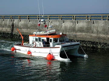
Tech Marine Service's (Great Yarmouth, UK) Genesis provided a stable and maneuverable platform to conduct all remote sensing and ROV activities (Figure 1). Genesis, a 10-ton Catamaran, is capable of cruising at a speed of 20-25 knots and has a fuel range of 300 nautical miles. The wheelhouse equipment included an Icom IC-M56 VHF radio, Kelvin Hughes compact VHF radio, Furuno 4-tone daylight display radar, Cetrek autopilot, Trimble Navtrac XL GPS, JMC V-103 color depth sounder, Cetrek Profish 12 chart plotter, and magnetic compass. The aft deck area (3-x-4.9 meters) was spacious and open to allow unencumbered operations. The deck equipment included a 400 Kgs Hi-Ab crane with winch to provide a safe and effective means of launching and recovering the ROV.
The On-Board Electronic Instrumentation
The on-board electronic instrumentation included the Marine Sonic Technology Ltd. (MSTL), Sea Scan PCã side-scan sonar systems, and Geometric's G880 cesium magnetometer. Coastal Oceanographic's hydrographic package, HYPAC, provided all survey tract information, including helm guidance, and magnetic data collection. Fugro SeaSTAR (UK) provided a satellite DGPS for precision positioning information. In FS 2001, the NSWC added a Deep Ocean Engineering (DOE) Phantom ROV to the equipment roster.
Navigation and Target Acquisition
The on-board navigation and positioning instrumentation included a Trimble AgGPS® 132 high-performance GPS receiver that uses differential correction services to calculate sub-meter positions in real-time and HYPACK® MAX, produced by Coastal Oceanographic, Inc. (Middlefield, Connecticut), for planning, conducting, editing and publishing hydrographic surveys.
Operational Constraints Encountered
Operational constraints encountered within the project area included: 1) tidal predictions; 2) current velocity; 3) partially awash and submerged obstructions; 4) turbidity and plankton; and 5) fouling and entanglement hazards. The Naval European Meteorology and Oceanography Center (NEMOC), in Rota, Spain, provided UA weather data services. NEMOC is the U.S. Navy's center for the production and distribution of value added Meteorology and Oceanographic (METOC) products within Europe, continental Africa, the Mediterranean, Baltic and Black Seas.
Data Processing and Correlations
HYPACK® MAX contained the software tools necessary to process the raw magnetic data files. Sea Scan® PC Review software provided the tools necessary to process the acoustic data. Between FS 2000-2001 the NHC processed more than 1,900 magnetic anomalies and 752 sonar targets. As part of the data analysis, the NHC established guidelines to the selection process used to recommend and prioritize the magnetic and acoustic data. This selection process did not focus on complex magnetic anomalies with a high-amplitude or an associated side-scan sonar target. Instead, the process established an accurate method of setting priorities for each target according to the historic potential. In addition, as part of the processing and selection task, significant magnetic data and compelling sonar images were added into ArcView© GIS (Version 3.1). Development of the Arc View© GIS database allows, as part of the data analysis, a selection process to recommend and prioritize magnetic anomalies, anomaly clusters, and associated side-scan sonar targets.
Project Results
In addition to providing valuable site data, FS 2000 allowed the UA to sort out logistical difficulty shipping/receiving and operational constraints such as tidal lock schedules and high velocity currents. In addition, it became apparent that UXO could affect the ROV operations planned for FS 2001.In FS 2000 (June-July), the UA and INA completed offshore segments of Utah Beach (401 hectares), Point du Hoc (158.7 hectares), and Omaha Beach (1,390 hectares). During this first season, the UA and INA documented more than 440 magnetic anomalies and 312 sonar targets. One target proved to be an intact Landing Barge Vehicle (LBV) designed to carry vehicles. The LBV would have been associated with Landing barge squadrons X and Y, Force U, US 7 Corps (33rd and 34th Supply and Repair flotilla and the 8th, 19th, and 20th LBV).
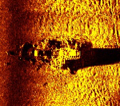
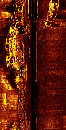
In FS 2001 (May-June), the UA returned to Normandy and completed the near-shore (shallow water) segments of Utah Beach (605.6 hectares), Point du Hoc (226.5 hectares), and Omaha Beach (570 hectares), shoreward of the caisson breakwater (Figure 2). In addition, the NSWC group assisted UA to examine sites at Utah (six sites, including one intact LBV), Point du Hoc (one LBV), and Omaha (15 sites including three Double Duty [DD] tanks). The UA and NSWC also documented the remains of five known sites (USS Corry (DD 463), USS Meredith (DD 726), USS Rich (DE 695), USS Tide (AM 125), and, LST 523).The LBV off Point du Hoc could be the remains of a supply boat that swamped while carrying reserve ammunition for US Army companies D, E, and F of the 2nd Rangers. The landing ship tank (LST) 523 investigated off Utah Beach revealed substantial impact at mid ship section. While investigations of the Tide, attached to Minesweeper Squadron A, Utah area, revealed that previous French salvage operations removed its remains due to hazardous unexploded ordnance (Figure 3).
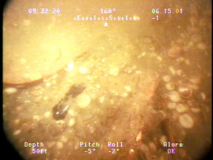
Unexploded Ordnance encountered during the FS 2001 season included numerous shell casings typically found lying against the outside of the sunken Sherman M4s, reams of small arms ammunition lying exposed on the seabed and one glass ampoule containing either acid (fuse) or iodine (medicinal) (Figure 4).
Conclusions
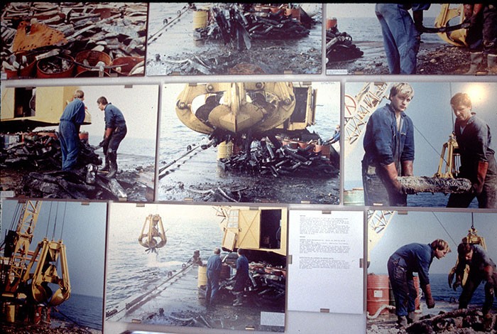
The data collected during FS 2000 and 2001 revealed important information about site preservation and integrity. Sonar imagery and video documentation revealed that a majority of the sites was subjected to substantial impacts during post war salvage operations. A local informant and salvage operator, Jacques Lemonchois, verified that the French government let contracts to remove vessels deemed an obstruction or hazardous due to unexploded ordnance (Figure 5). Leomonchois began clearing some of the wrecks deemed dangerous in 1970. In addition, Lemonchois established the Musee de Epaves, Sous-Marines Du Dubarquement dedicated to Operation Neptune.
2002 Survey Results
On June 6, 1944 an expeditionary force comprised of soldiers from the United States, Great Britain, Canada, Poland, Norway, and other nations, including members of the French Resistance, crossed the English Channel for the Allied invasion of Normandy. Within 24 hours, over 5,000 vessels transported 175,000 Allied troops and their equipment, including 50,000 vehicles of all types, across 60 to 100 miles (96.56-160.9 kilometers) of open water to assault a well-fortified German beachhead. Dubbed Operation Overlord, the waterborne assault was described by British Prime Minister Winston Churchill as the most difficult and complicated operation of its kind to ever take place. At the close of D-Day, the allied invasion front stretched across more than 55.92 miles (90 kilometers) of beachhead. The Atlantic Wall, which took the Germans four years to construct and absorbed a large percentage of German materiel and labor, fell in just one day. However, Allied penetration of the Atlantic Wall came at a costly price, resulting in nearly 5,000 casualties. By D-Day plus one, the wreckage of landing craft and motorized vehicles were spread across the invasion beachheads to such an extent that landing operations were suspended.
In 2000 the Naval History & Heritage Command's Underwater Archaeology Branch began a three-year archaeological remote-sensing survey to locate and document U.S. Navy losses incurred during the D-Day invasion. The remnants of historic craft located off the allied landing sectors represents a microcosm of World War II-era U.S. Navy shipwrecks and submerged battlefields worldwide, as well as the largest known assemblage of naval-related vessel losses anywhere in the world. The project was initiated in large part to develop a criteria or template for the scientific archaeological assessment and preservation of a significant historical resource base. Data gathered during the survey also represented a fundamental function of the Underwater Achaeology Branch: to identify, locate, evaluate, nominate, and protect historically significant submerged U.S. Navy properties.
The project area included offshore segments of the American landing sectors--designated Utah Beach, Point du Hoc, and Omaha Beach--along a 20-mile stretch of the Normandy coastline. To assist in the discovery and interpretation of American naval losses during the D-Day assault, the Service Hydrographique et Oceanographique de la Marine (SHOM) provided the U.S. Navy a database of all current wreck and obstruction chartings for the Baie de Seine. The Underwater Achaeology Branch employed an array of remote-sensing equipment during the survey, including a magnetometer, side-scan sonar, remotely operated vehicles (ROVs), and a multibeam echo-sounding system (MBES).
The Naval Surface Warfare Center, Carderock (NSWCC) supplied the project with a Deep Ocean Engineering Phantom III S2 vehicle, which served as a remotely operated work platform to collect digital still images and streaming video of selected targets and features. During the 2001 and 2002 field seasons, ROVs collected approximately 110 hours of quality video and permitted project archaeologists to maintain complete and real-time quality control over the data collection process. MBES operations were also quite successful; the near field beam-forming capability of the RESON 8125, combined with 3-D visualization techniques, provided an unprecedented level of detail to the survey data. In many instances, project archaeologists were able to recognize individual components of a particular wreck (ramps, gun turrets, hatches, etc.), its state of preservation, and impact on the surrounding seafloor.
During the 2002 field season, the Underwater Achaeology Branch marked a project milestone by completing remote-sensing operations at Banc du Cardonnet (906 hectares/3.498 square miles), Utah Beach (1,206 hectares/4.656 square miles), Pointe du Hoc (384.7 hectares/1.485 square miles), and Omaha Beach (2,226 hectares/8.595 square miles) locating various vessels such as landing ship tanks (LST), landing craft tanks (LCT), landing craft infantry (LCI), destoryers (DD), and cylone class patrol ships. The Banc du Cardonnet survey grid contained the charted remains of LCT-777, LCT-244, LCT-305, LCI-232, PC-1261, a possible Sherman tank, three possible vehicles (e.g., a possible U.S. Army DUKW), one barge, USS Meredith (DD-726), LST-523, HMS Minster, 10 uncharted and undetermined wreck sites and USS Rich (DE-695). Of these, the Underwater Achaeology Branch positively identified only Meredith and Minster. Archival research and oral history interviews provide compelling evidence that the identities of LST-523 and LST-496 have been confused with one another. Moreover, contemporary photographs and salvage reports indicate that LCT-777 and LCT-305 are not on the Banc du Cardonnet, as currently charted.
The Utah Beach survey grid contained the charted remains of two unidentified barges, three unidentified wrecks, one liberty ship, SSCharles Morgan, HM LCT-524 and USS Tide. In addition to charted wrecks, the survey revealed an unidentified landing craft lying adjacent to the charted liberty ship. Despite collecting a significant amount of field data and archival material, the Underwater Achaeology Branch was unable to positively identify the liberty ship, the landing craft adjacent to it, or the two barges. However, archival data did reveal considerably discrepancy between the charted and actual locations of the SS Charles Morgan.
Survey efforts within the Pointe du Hoc grid focused on an uncharted and unidentified wreck that was first investigated by the Underwater Achaeology Branch in 2001. The wreck rests on a rock reef approximately one kilometer NNW of Pointe du Hoc. Sonar data indicated that it measures approximately 13 meters in length, is 5 meters wide, rises approximately one meter above the seabed, and is about 334 meters SE of a landing pontoon charted by SHOM. It also appears to be associated with four other unidentified targets. These targets are clustered as two distinct pairs only 8 meters apart. Although the Underwater Achaeology Branch collected additional side-scan and multibeam sonar data at the wreck site in 2002, it still could not be identified due to a lack of sufficient diagnostic features.
The Omaha Beach survey grid contained numerous charted and uncharted wrecks and obstructions. Charted wrecks included the USS Partridge (ATO-138), USS Susan B. Anthony (AP-72) and caissons and block ships associated with the Mulberry Group of Saint-Laurent-sur-Mer. In addition to investigating known wreck sites, the Underwater Achaeology Branch discovered at least five unidentified craft and collected multibeam and sonar data within the Omaha Beach survey sector that verified the remains of two M4A2 Sherman tanks and two other tracked vehicles. The Underwater Achaeology Branch also surveyed an area near Pointe et Raz de la Percee to locate and examine an unidentified LST charted by SHOM. The exposed component of this wreck comprised a section of hull measuring approximately 25.7 meters in length, 9.27 meters in beam, and rising to a height of 1.6 to 2.5 meters above the seabed. Although originally labeled by SHOM as the remains of an unidentified LST, the craft's beam dimensions measure about 6.1 meters narrower than an LST class craft. In addition, its two GM 6-71 engines are much smaller than the 12-cylinder GM 12-567 engines that powered World War II-era LSTs.
The Underwater Achaeology Branch's three-year archaeological remote-sensing survey to locate and document U.S. Navy D-Day losses concluded in the summer of 2002. The project has now entered a new phase of intensive archival research and the collection of oral histories from D-Day participants. The majority of archival material was collected from the National Archives and Records Administration and comprises cartographic material (such as Bigot Maps), textual records (i.e., war diaries, action reports, deck logs) and combat-related photographic documents (both still photographs and movie film footage).
While comparative imagery analysis provided cursory identification of vessel types, it will take a great deal of archival research to sift through the scant historical data and present positive identifications for the wreck sites detected during the remote-sensing phase. Data integration and Geographical Information Systems products allow the implementation of spatial analyses techniques, which will be particularly useful in visualizing, among other things, operational-level battlefield tactics during the Normandy invasion.
