Pearl Harbor, ZE files, Navy Department Library.
Share
Connect
- Expand navigation for WWII - Battle of Midway WWII - Battle of Midway
- Bombing Squadron 6
- Commander Cruisers Pacific Fleet Report
- Commander-in-Chief, Pacific Fleet
- Commander Destroyer Squadron Six Action Report
- Interrogation of Japanese Prisoners
- TF 16 Action Report
- USS Enterprise Action Report
- USS Hammann Action Report
- USS Hornet Action Report
- USS Yorktown Action Report
- Expand navigation for WWII - Pearl Harbor Attack WWII - Pearl Harbor Attack
- Expand navigation for Ships A-C Ships A-C
- USS Allen (DD-66) Action Report
- USS Antares (AKS-3) Action Report
- USS Argonne (AG-31) Action Report
- USS Arizona (BB-39) Action Report
- USS Avocet (AVP-4) Action Report
- USS Aylwin (DD-355) Action Reports
- USS Bagley (DD-386) Action Report
- USS Blue (DD-387) Action Report
- USS Bobolink (AM-20) Action Report
- USS Breese (DM-18) Action Report
- USS Cachalot (SS-170) Action Report
- USS California (BB-44) Action Report
- USS Case (DD-370) Action Report
- USS Cassin (DD-372) Action Report
- USS Castor (AKS-1) Action Report
- USS Chew (DD-106) Action Report
- USS Conyngham (DD-371) Action Report
- USS Cummings (DD-365) Action Report
- USS Curtiss (AV-4) Action Report
- Expand navigation for Ships D-L Ships D-L
- USS Dale (DD-353) Action Report
- USS Detroit (CL-8) Action Report
- USS Dewey (DD-349) Action Report
- USS Dobbin (AD-3) Action Report
- USS Dolphin (SS-169) Action Report
- USS Downes (DD-375) Action Report
- USS Enterprise (CV-6) Air Group Action Report
- USS Enterprise (CV-6) Scouting Squadron 6 Action Report
- USS Farragut (DD-348) Action Report
- USS Gamble (DM-15) Action Report
- USS Helena (CL-50) Action Report
- USS Helm (DD-388) Action Report
- USS Henley (DD-391) Action Report
- USS Honolulu (CL-48) Action Report
- USS Hulbert (AVD-6) Action Report
- USS Hull (DD-350) Action Report
- USS Jarvis (DD-393) Action Report
- Expand navigation for Ships M-R Ships M-R
- USS MacDonough (DD-351) Action Report
- USS Maryland (BB-46) Action Report
- USS Medusa (AR-1) Action Report
- USS Minneapolis (CA-36) Action Report
- USS Monaghan (DD-354) Action Report
- USS Montgomery (DM-17) Action Report
- USS Mugford (DD-389) Action Report
- USS Narwhal (SS-167) Action Report
- USS Neosho (AO-23) Action Report
- USS Nevada (BB-36) Action Report
- USS New Orleans (CA-32) Action Report
- USS Oglala (CM-4) Action Report
- USS Oklahoma (BB-37) Action Report
- USS Ontario (AT-13) Action Report
- USS Patterson (DD-392) Action Report
- USS Pelias (AS-14) Action Report
- USS Pennsylvania (BB-38) Action Report
- USS Perry (DMS-17) Action Report
- USS Phelps (DD-360) Action Report
- USS Phoenix (CL-46) Action Report
- USS Preble (DM-20) Action Report
- USS Pruitt (DM-22) Action Report
- USS Pyro (AE-1) Action Report
- USS Rail (AM-26) Action Report
- USS Raleigh (CL-7) Action Report
- USS Ralph Talbot (DD-390) Action Report
- USS Ramapo (AO-12) Action Report
- USS Ramsay (DM-16) Action Report
- USS Reid (DD-369) Action Report
- USS Rigel (ARb-1) Action Report
- Expand navigation for Ships S-Z Ships S-Z
- USS Sacramento (PG-19) Action Report
- USS San Francisco (CA-38) Action Report
- USS Selfridge (DD-357) Action Report
- USS Shaw (DD-373) Action Report
- USS Sicard (DM-21) Action Report
- USS Solace (AH-5) Action Report
- USS St. Louis (CL-49) Action Report
- USS Sumner (AG-32) Action Report
- USS Swan (AVP-7) Action Report
- USS Tangier (AV-8) Action Report
- USS Tautog (SS-199) Action Report
- USS Tennessee (BB-43) Action Report
- USS Tern (AM-31) Action Report
- USS Thornton (AVD-11) Action Report
- USS Tracy (DM-19) Action Report
- USS Trever (DMS-16) Action Report
- USS Tucker (DD-374) Action Report
- USS Turkey (AM-13) Action Report
- USS Utah (AG-16) Action Report
- USS Vestal (AR-4) Action Report
- USS Vireo (AM-52) Action Report
- USS Ward (DD-139) Action Report
- USS Wasmuth (DMS-15) Action Report
- USS West Virginia (BB-48) Action Report
- USS West Virginia (BB-48) Salvage Report
- USS Whitney (AD-4) Action Report
- USS Worden (DD-352) Action Report
- USS Zane (DMS-14) Action Report
- Commander Battle Force Action Report
- Commander Battleships, Battle Force Action Report
- Destroyer Division 80, Battle Force Action Report
- Destroyer Flotilla One, Battle Force Action Report
- Minecraft, Battle Force Action Report
- Minecraft, Battle Force, Mine Division One Action Report
- Minecraft, Battle Force, Mine Division Two Action Report
- Motor Torpedo Squadron One Action Report
- Patrol Squadron (PBY) Eleven Action Report
- Patrol Squadron (PBY) Twenty-Two Action Report
- Patrol Wing (PBY) One Action Report
- Patrol Wing (PBY) Two Action Report
- Pearl Harbor Mooring and Berthing Plans
- Rear Admiral R.H. Jackson, USN (Ret.) Report on Pearl Harbor Attack
- Submarine Squadron Four Action Report
- Expand navigation for Ships A-C Ships A-C
- Korean War - Carrier Air Groups
- Expand navigation for Korean War - Carrier Combat Korean War - Carrier Combat
- Antietam (CV 36)
- Badoeng Strait (CVE 116)
- Bairoko (CVE 115)
- Bataan (CVL 29)
- Bon Homme Richard (CVA 31)
- Boxer (CVA 21)
- Essex (CVA 9)
- Kearsarge (CV 33)
- Lake Champlain (CVA 39)
- Leyte (CV 32)
- Oriskany (CVA 34)
- Philippine Sea (CV 47)
- Point Cruz (CVE 119)
- Princeton (CV 37)
- Rendova (CVE 114)
- Sicily (CVE 118)
- Valley Forge (CV 45)
Related Content
Sources
Topic
- Theater of Operations--Pacific
- Places-Shore Facilities--Bases-Stations-Labs-Installations
- Theater of Operations--American
Document Type
- Primary Source Document
- Map
Wars & Conflicts
- World War II 1939-1945
Navy Communities
File Formats
- Image (gif, jpg, tiff)
Location of Archival Materials
Author Name
Place of Event
Recipient Name
Pearl Harbor Mooring and Berthing Plans
Mooring and Berthing Plans

Caption:
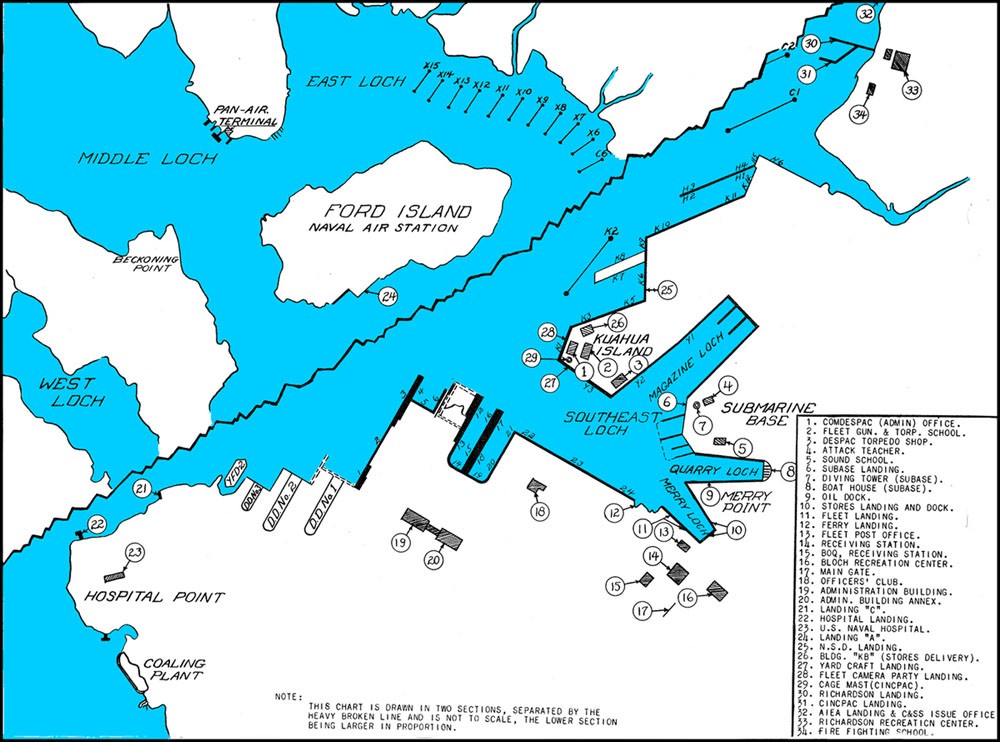
Note: This chart is drawn in two sections, separated by the heavy broken line and is not to scale, the lower section being larger in porportion. Key: 1. COMDESPAC (Admin) Office. 2. Fleet Gun & Torp. School. 3. DESPAC Torpedo Shop. 4. Attack Teacher. 5. Sound School. 6. SUBASE Landing. 7. Diving Tower (SUBASE). 8. Boat House (SUBASE). 9. Oil Dock. 10. Stores Landing and Dock. 11. Fleet Landing. 12. Ferry Landing. 13. Fleet Post Office. 14. Receiving Station. 15. BOQ, Receiving Station. 16. BLOCH Recreation Center. 17. Main Gate. 18. Officers' Club. 19. Administration Building. 20. Admin. Building Annex. 21. Landing "C". 22. Hospital Landing. 23. US Naval Hospital. 24. Landing "A". 25. N.S.D. Landing. 26. Bldg "KB" (Stores Delivery). 27. Yard Craft Landing. 28. Fleet Camera Party Landing. 29. Cage Mast (CINCPAC). 30. Richardson Landing. 31. CINCPAC Landing. 32. AIEA Landing & C&SS Issue Office. 33. Richardson Recreation Center. 34. Fire Fighting School.

Caption:
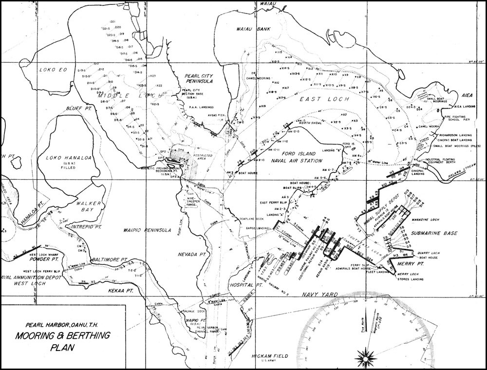
Chart of Pearl Harbor, Oahu, T.H., Mooring & Berthing Plan: showing the mooring and berthing areas around Ford Island Naval Air Station, Powder Point, Naval Ammunition Depot West Loch, Hickham Field, Hospital Point, Navy Yard, Submarine Base, AIEA, along the East Loch, Pearl City Peninsula, Middle Loch, to Bluff Point.
Footnotes
Published: Tue Mar 20 09:56:33 EDT 2018
- Accessibility/Section 508 |
- Employee Login |
- FOIA |
- NHHC IG |
- Privacy |
- Webmaster |
- Navy.mil |
- Navy Recruiting |
- Careers |
- USA.gov |
- USA Jobs
- No Fear Act |
- Site Map |
- This is an official U.S. Navy web site


