
Charting the Seas
After you learn about longitude and latitude, try this
Coordinates help us find locations anywhere without the use of street signs, street blocks, or other kinds of markings. We use coordinates called latitude and longitude to help us find locations on the open sea. When coordinates are written, latitude is always listed first, then longitude.
Latitude and longitude are imaginary lines on a globe. The lines that run east and west, parallel to the equator are called latitude. These lines are written in degrees (°) north and south of the equator. Each degree of latitude is divided into 60 minutes and each minute into 60 seconds, as if you were telling time. A degree of latitude measures about 69 miles on the earth's surface. The equator is at 0° latitude, while the North Pole is at 90° north and the South Pole is at 90° south.

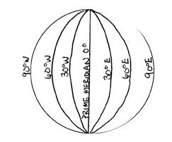
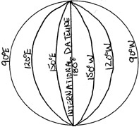
The lines that run north and south are called lines of longitude. Meridian is another name for a line of longitude. An international committee agreed to call the meridian that passes through Greenwich, England, the Prime Meridian. The meridian that is halfway across the world from the Prime Meridian is 180° longitude and is called the International Date Lines of longitude are also written in degrees (°) east and west of the Prime Meridian and International Dateline.
 |
 |
Now test your knowledge of latitude and longitude by completing the Charting Activity.

