John McDonnell (T-AGS-51)
1991–
The first U.S. Navy ship named for John R. McDonnell (1933–1984). In 1977, Capt. McDonnell assumed command of the Naval Oceanographic Office and oversaw its move from Washington, D.C., to Stennis Space Center, Miss. The following year, he served as the first commander of the newly formed Naval Oceanography Command, subsequently redesignated Naval Meteorology and Oceanography Command.
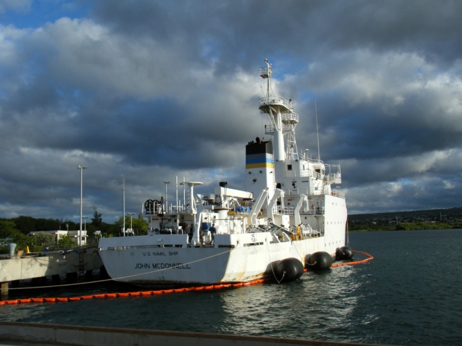
(T-AGS-51: displacement 2,238; length 208'; beam 42'; draft 14'; speed 16 knots; complement 33; armament none; class Pathfinder)
John McDonnell (T-AGS-51) was laid down on 3 August 1989 at Moss Point, Miss., by Halter Marine, Inc.; launched on 13 December 1990; sponsored by Mrs. Mary McDonnell, wife of Capt. McDonnell; and was placed in service with the Military Sealift Command (MSC) on 15 November 1991.
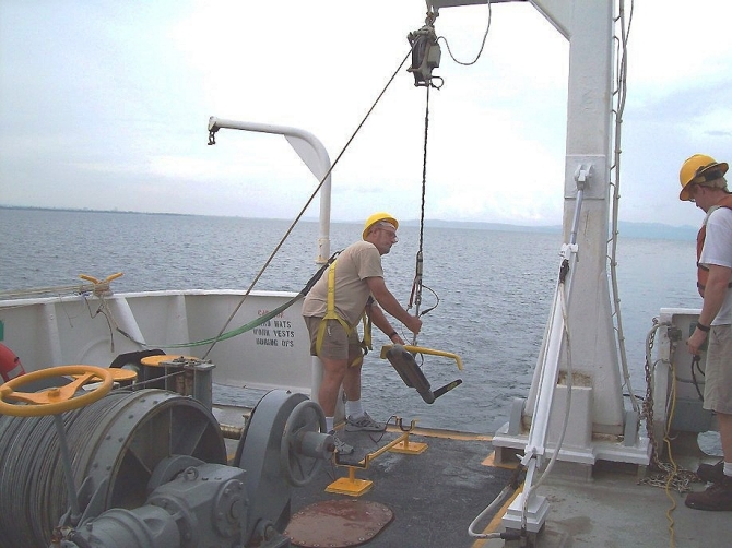
The MSC’s Special Mission program supports worldwide oceanographic programs with ships like John McDonnell that perform acoustical, biological, physical, and geophysical surveys. These ships gather data that provides much of the military’s information on the ocean environment. The collected data helps to improve technology in undersea warfare and detecting enemy ships. In particular, John McDonnell utilized a variety of underway, towed, and over-the-side systems to support bathymetry, hydrography, physical oceanography, and navigation. She carried 34-foot survey launches for data collection in coastal regions with depths between 10 and 600 meters and in deep water to 4,000 meters. The ship utilized a small diesel for propulsion at towing speeds of up to six knots. John McDonnell also had SIMRAD high-frequency active hull-mounted and side scan sonars.
In addition to her oceanographic surveys, John McDonnell rose to emergent tasking on several occasions. Using her side scan sonar, embarked Detachment 124 located two downed USAF F-16 Fighting Falcons in the Northern Arabian Gulf in 1993, and the wreckage of a Navy helicopter in the Strait of Hormuz in 1994. In 1996, she located a crashed Grumman F-14 Tomcat in the Central Arabian Gulf.
A magnitude 9.0 earthquake occurred off the west coast of Sumatra, Indonesia, triggering a tsunami across the Indian Ocean littoral, on 26 December 2004. The waves reached heights of 30 feet in shallow waters and a width sometimes extending to six-miles, and the disaster killed more than 230,000 people. Combined Support Force 536 coordinated Operation Unified Assistance—multinational relief efforts. United States naval forces often reached disaster zones before international aid agencies, and aircraft delivered supplies and emergency responders to otherwise inaccessible inland areas.
Ships that supported these operations included aircraft carrier Abraham Lincoln (CVN-72), guided missile cruisers Bunker Hill (CG-52) and Shiloh (CG-67), guided missile destroyers Benfold (DDG-65), Milius (DDG-69), and Shoup (DDG-86), guided missile frigate Thach (FFG-43), amphibious assault ships Bonhomme Richard (LHD-6) and Essex (LHD-2)—which relieved Bonhomme Richard on 18 January 2005—dock landing ships Fort McHenry (LSD-43) and Rushmore (LSD-47), amphibious transport dock Duluth (LPD-6), and Coast Guard high endurance cutter Munro (WHEC-724).
Vessels of the Military Sealift Command also supported Unified Assistance including at times hospital ship Mercy (T-AH-19), fast combat support ship Rainier (AOE-7), combat store ships Niagara Falls (T-AFS 3) and San Jose (T-AFS-7), and fleet replenishment oilers John Ericsson (T-AO-194), Tippecanoe (T-AO-199) and Yukon (T-AO-202). Maritime prepositioning ships of the command that took part in these humanitarian relief operations comprised container and roll-on/roll-off ships PFC James Anderson, Jr. (T-AK-3002), Cpl Louis J. Hauge, Jr. (T-AK-3000), 1st Lt Alex Bonnyman (T-AK-3002), 1st Lt Harry L. Martin (T-AK-3015), 1st Lt Jack Lummus (T-AK-3011), and Maj Stephen W. Pless (T-AK-3007). Oceanographic survey ships John McDonnell and Mary Sears (T-AGS-65) conducted hydrographic surveys of the ocean bottom off the Indonesian coast, near the epicenter of the earthquake, to collect data to assist in predicting natural disasters. Despite earthquake aftershocks and logistic problems, U.S. aircraft flew 1,747 missions and transported 3,043 passengers during these operations. Sailors and marines in these aircraft and on board the ships delivered 5.92 million pounds of supplies to people in Indonesia, Sri Lanka, and Thailand.

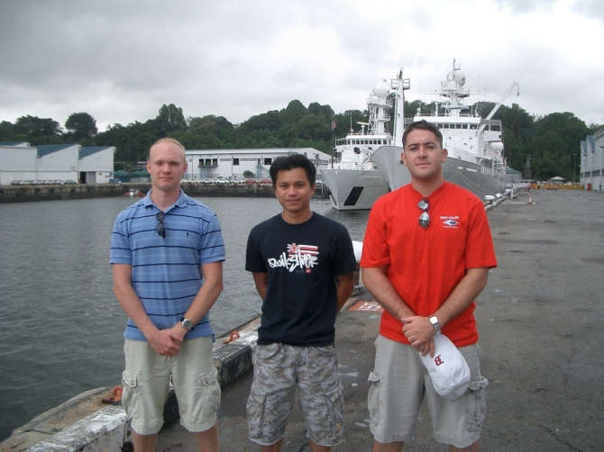
In the early hours of 5 February 2006, three men of the ships company, merchant mariner and John McDonnell’s Third Mate Colin Campbell and BM2 Paulryan Judi and MASN Gregory Chaney provided life-saving medical assistance to the victim of a knife attack while the ship visited Singapore. While riding in a taxi near a popular Singapore tourist district, the three crewmen observed a violent altercation between two local men, involving what appeared to be an 18-inch machete. They spotted a man fleeing from the scene who, according to one of the crewmembers, attempted to conceal the weapon in his trousers.
They asked the driver to stop immediately. Following a heavy trail of blood, they discovered the victim near a local convenience store. Campbell, Judi, and Chaney had completed basic training in first aid. They afterward described the victim’s wounds as very serious and the loss of blood substantial enough to be life threatening. The man had multiple lacerations to his left forearm, including visible flesh and bone wounds. He also appeared to show symptoms of shock. Judi ensured that the attacker had not returned to the scene and began to check the victim’s pulse. At the same time, Chaney applied a tourniquet to the most serious wound by using borrowed clothing and a belt from a bystander. Campbell telephoned police and asked the operators of the convenience store to call an ambulance. The victim survived surgery. “The courage and bravery displayed by the sailors and Third Officer Campbell,” Capt. Michael Bacher, the ship’s master, considered, “are reflective of the best the Navy has to offer.”

In late summer 2008, John McDonnell was wrapping up a 30-day survey operation when the ship, with her embarked crew of 10 naval surveyors, along with 23 mariners who worked for a private company under contract to MSC, received orders to make for the southern Philippines to assist in the search for a missing Philippine Air Force Lockheed C-130 Hercules. The 37-year-old plane, with two pilots, seven air crewmen, and two soldiers on board, crashed shortly after taking off from Francisco Bangoy International Airport at Davao, Mindanao, on 25 August 2008. Eyewitnesses claimed that the Hercules quickly lost altitude and banked sharply left before crashing into Davao Gulf. There were no survivors.
John McDonnell reached the gulf on 30 August. Philippine navy officials provided the ship’s company with several prospective wreckage locations to help them in their search. A local Philippines navy vessel stood by to lend support if needed and provided John McDonnell’s master, Capt. Robert Mattsen, with navigational charts for Davao Gulf. The ship’s hydrographers went to work right away, deploying sophisticated side-scan imaging and multi-beam, depth-defining sonars to survey the seabed. “The water was relatively shallow, but it gets deep very fast,” Susan Sebastian a senior oceanographic representative summarized. The ship failed to locate any wreckage in the first position, and began surveying a second area to the south recommended by Philippine authorities—but again without success.
The mariners placed their embarked hydrographic survey launch, a 34-foot, 15,000-pound watercraft used for shallow water surveys, into the water the following day. Able Seaman David Arcilla was on board the launch vessel when they encountered some local fisherman. “The fishermen told Arcilla where they saw the aircraft go down,” Sebastian explained. “He was instrumental since he [Arcilla] is Filipino and could speak with the fisherman and translate what they told us.” Technician Steve Posey operated the ship’s side-scan sonar on 4 September when he discovered the wreckage in shallow water near the location that the fishermen had described, about a mile east of Bucana village. “It was very exciting to see the incredible image of an airplane on the seafloor scroll by in the survey lab,” Sebastian said. “The plane was largely intact on the seabed, and the wings and tail section were very apparent in the imagery.” Following the discovery, the ship came about and returned to Singapore on 16 September.

John McDonnell was inactivated and stricken on 16 August 2010, and subsequently delivered to the Navy Inactive Ships Program in Pearl Harbor, Hi. In her nearly 20 years of service, John McDonnell collected approximately 392,500 nautical miles of swath bathymetry and 35,000 nautical miles of side scan sonar imagery, in addition to charting and verifying thousands of navigation hazards. In support of the Navy’s safety of navigation program, the ship dropped 17,900 expendable bathythermograph probes and conducted 4,500 conductivity-temperature-depth casts. During one such operation (22 May–15 Jun 2010), she carried out a joint survey mission with the Indonesian Navy, mapping about 300 square miles of previously unsurveyed seabed off the coast of northern Sumatra.

Detailed history pending.
Mark L. Evans
27 January 2016


