
The Navy Department Library
Fleet Air Wing Four Strikes, NAVAER 50-40T-2
Aerology and Naval Warfare
Aerology and Naval Warfare
Fleet Air Wing Four Strikes
NAVAER 50-40T-2
CHIEF OF NAVAL OPERATIONS
AEROLOGY SECTION
WASHINGTON, D.C.
JUNE, 1945
Foreword
This is one of a series of pamphlets dealing with the weather aspects of Naval and Amphibious Warfare. The data on which these studies are based are taken from official documents and reports submitted to the Navy Department. The material has been collated and presented in a semi-technical form with particular attention given to the operational aspects of weather.
During the preparation of this study, it was found that weather data submitted by the various commands were occasionally at variance. An effort has been made to reconcile these differences in order to provide an accurate account of the sequence of weather conditions as forecast for the Force Commander, to describe the actual weather conditions observed during the operation, and to give a practical explanation of these weather conditions.
It is hoped that these studies will afford a clear view of the use of weather information during the planning, strategical, and tactical phases of the operation, and that they will form a basis for a better understanding of the application of weather information in future operations.
The primary objective of these analyses is to assist those officers who are charged with the responsibility for the planning and execution of similar operations.
/s/
Vice Admiral, U.S.N.,
Deputy Chief of Naval Operations, (Air).
--i--
Preface
When Fleet Air Wing FOUR (then known as Patrol Wing FOUR) first moved en masse to the Alaskan - Aleutian area in May 1942, the most commonly accepted view of North Pacific weather was summarized in one or two words, "Terrible", "Impossible". Certainly the weather in that area was definitely not favorable for flight operations, but it was more "terrible" in the tales of the old-timers and in the imaginations of the newcomers than in fact and, being at war, the concept of "impossible" could not be entertained. As the Aleutian Operation moved westward and the Wing with it, we gained experience in dealing with the Aleutian weather. As we gained experience, we also gathered knowledge. When at last we stood on Attu we had behind us nearly two years of experience; we had a corps of trained weather observers; we had weather-wise pilots who knew that the "dread williwaw" of lurid news accounts were no more than extremely sharp-edged gusts encountered mostly close to leeward or bluffs and cliffs; that the storms and fogs and fronts of the North Pacific conformed to the laws which govern weather everywhere. We had also finally attained a position from which we could send aircraft, with weathermen, far enough to the weather side of the Bering so that we could observe and plot the weather before it was on us at Attu, an advantage long denied us by the Japs' possession of the weather gauge in the early days of the war. The most vitally important thing we had, however, was mutual confidence between the various elements of the Wing involved in preparing for and accomplishing a mission. The pilots trusted the aerologists and had confidence in their predictions. This trust and confidence was engendered by the aerologists' incurable habit of flying with the pilots through their own predicted weather and the repeatedly proved accuracy of their forecasts. The weathermen had the confidence in their own work which comes with long study, careful tabulation and recording of long-gathered data and thorough analysis of all the elements involved. The Wing Commander had confidence in the weathermen's advice and in the pilots' ability to fly the weather in the planes provided.
The whole thing was a joint operation and its success was the result first, of a determination not to accept the weather as "impossible" but to learn how to circumvent it and second, by all hands working all-out together to find the solution and make it work. The record shows that our Navy-trained pilots and aircrews, assisted and guided by courageous and devoted weather scientists, backed up by an efficient ground organization, can and will tackle anything and surmount any difficulties to accomplish their assigned missions.
/s/
L.E. GEHRES,
Captain, U.S. Navy,
(formerly Commodore and Commander Fleet Air Wing FOUR)
--ii--
Fleet Air Wing Four Strikes
Summary
- BY MAKING WEATHER THE PRIMARY CONSIDERATION, IT IS POSSIBLE TO SCHEDULE ROUTINE FLIGHT OPERATIONS WITH MAXIMUM EFFECTIVENESS AND MINIMUM LOSS IN A REGION OF THE WORLD WHERE FLIGHT CONDITIONS ARE ALMOST UNIFORMLY HAZARDOUS.
- FOR THE MOST EFFECTIVE SCHEDULING OF ROUTINE OPERATIONS, THE LIMITATIONS OF THE AIRCRAFT USED - SERVICE CEILING, FUEL CAPACITY, ICING CHARACTERISTICS - MUST BE INTERPRETED IN TERMS OF EXISTING AND FORECAST OPERATIONAL WEATHER FACTORS.
- EVERY AVAILABLE SOURCE OF INFORMATION SHOULD BE USED TO PROVIDE THE WEATHER REPORTS NECESSARY FOR ACCURATE WEATHER ANALYSIS AND FORECASTING. IN ADDITION TO STANDARD SOURCES, SEARCH AND WEATHER PLANES AS WELL AS SURFACE CRAFT SHOULD BE EMPLOYED IN OBTAINING THE REQUISITE WEATHER DATA NECESSARY FOR INFORMED OPERATIONS.
Introduction
In the scheduling of air operations in most portions of the world, weather is but one of a number of considerations. The quality and quantity of Aleutian weather is such, however, that for air operations near these islands, flight weather conditions are of extreme importance. When Fleet Air Wing FOUR was stationed on Attu island in the Aleutians and ordered to conduct routine bombing and photographic reconnaissance of the Japanese bases on Paramushiru, the Wing Commander decided that weather was the limiting factor for successful mission performance.
The region traversed by the flights corresponds, more or less, with that invaded by storm centers and frontal systems which leave northern Asia, cross the Kamchatka peninsula and travel eastward over the Aleutian Islands to continental North America. The scheduling of protracted flights through this region is difficult since the planes may take off under satisfactory weather conditions but may encounter poor or bad flying weather en route or a "closed" base on return. The extent of the difficulty involved in flying in this area can be realized only when consideration is given its location north of the 50th
--1--
parallel where a frontal disturbance is always accompanied by icing and where the icing level frequently extends to the surface.
Fleet Air Wing FOUR used PBY's and PV's for the 1,240-mile round-trip flight from its base on Attu to Paramushiru. The characteristics of these aircraft, particularly with respect to fuel capacity and susceptibility to icing, added several considerations to the Wing Commander's definition of "flyable weather" for these strikes. Mission requirements with respect to visibility and ceiling over the target area imposed several more.
Despite the realization of the dependency of successful strike completion on weather, it was immediately apparent that accuracy in weather forecasting would be difficult to achieve. Paramount among the difficulties was the complete absence of stations reporting weather to the west of Attu. The eastward progress of frontal systems from Asia toward Attu necessitated adequate knowledge of weather to the west in the preparation of an accurate forecast at that island. The synoptic map plotted from the usual reporting network was blank west of the 173rd West Longitude line.
In the following discussion, the specific problems introduced by Aleutian weather and the aircraft limitations will be listed together with the methods and devices employed by Commander, Fleet Air Wing FOUR in solving these problems. Finally, several actual missions will be described in order to demonstrate the application of the technique.
Aleutian Weather
The sequence of weather in the northern Pacific is complicated and the controlling factors complex so that any attempt to show the relationship between them would be inordinately lengthy. Rather than give a cursory and necessarily inadequate discussion at this point, it seems advisable merely to summarize the salient features of Aleutian weather.
A collection of seven years of surface weather maps for the area under question was examined. A study of these revealed the following information:
1. A front extended across the route between Attu and Paramushiru or over either of the terminals 28 per cent of the month of December, 17 per cent of January, 12 per cent of February, 14 per cent of March, 19 per cent of April, and 21 per cent of the time during May.
2. The influence of weather associated with a front south of the route and extending across the route or over the terminals was felt 13 per cent of the time during December, 15 per cent during January, 8 per cent during February, 16 per cent during March, 10 per cent during April, and 14 per cent during May.
3. Winds in excess of 25 knots prevailed over the area even in the absence of fronts or frontal weather 25 per cent of December, 35 per cent of January, 34 per cent of February, 28 per cent of March, 26 per cent of April, and 15 per cent of May.
--2--
This information may be summarized in tabular form in terms of the percentage of time during each month with unfavorable flying conditions. (Unfavorable flying conditions are said to occur when a front, frontal weather or winds in excess of 25 knots prevail over the route or at the terminals.)
| Dec. | Jan. | Feb. | Mar. | Apr. | May | |
|---|---|---|---|---|---|---|
| Per cent frequency of unfavorable flying conditions | 66 | 67 | 54 | 58 | 55 | 54 |
The difficulties involved in conducting routine operations in a region where flying conditions are unfavorable for more than 50 per cent of each month are self-evident.
Statistics from Attu for the period December 1943 - May 1944 were also studied in order to determine the nature of the weather at Fleet Air Wing FOUR's base. The following definitions were used in making the analysis:
1. Airport closed - when the visibility was less than one statute mile and/or the ceiling was less than 1,000 feet.
2. Flying conditions - unfavorable - ceiling less than 1,000 feet, visibility less than 21/2 miles or surface wind 20 knots or greater.
| ATTU | ||||||
|---|---|---|---|---|---|---|
| Dec. | Jan. | Feb. | Mar. | Apr. | May | |
| Per cent time closed | 6.3 | 20.1 | 27.7 | 28.1 | 20.8 | 13.2 |
| Per cent time flying conditions unfavorable | 13.3 | 42.3 | 47.6 | 41.9 | 27.2 | 13.4 |
Weather Requirements Imposed by Aircraft Limitations
As a first step in preparing for the missions, satisfactory flight conditions for the aircraft involved had to be defined.
The requirements of ceiling, visibility, and wind satisfactory for take-off and landing were not unusual. If a forecast indicated that the base, clear at the time of take-off, would be "closed" by the time of return eight to thirteen hours later, the mission would have to be postponed. ("Closed" meant ceiling less than 500 feet, visibility less than 3 miles.) Further, unfavorable weather conditions along the line of flight, such as a pronounced front, extensive turbulence, or icing conditions would make the operation extremely hazardous with bomb and gas loadings.
--3--
For military purposes - photography and bombing - weather conditions over the target area had to provide good visibility and preferably broken cloud cover which would provide some measure of protection against enemy searchlights, antiaircraft and defending fighters.
With respect to the limitations introduced by the use of PBY's and PV's, wind velocity and direction, and height and extent of cloud cover were of paramount importance. The fuel capacity of fully loaded PBY's and PV's is such that the distance covered on these raids was close to maximum. Were the ground speed cut down too much by adverse winds, return to base might be impossible. According to staff plans, a 25-knot headwind was considered the maximum allowable for successful mission performance - assuming that a 25-knot tail wind would be maintained on the return trip. This value was determined by a consideration of the following factors: (1) the rate of fuel consumption, (2) the distance from terminal to target and return, (3) the fuel capacity of the plane (including reserve), (4) the normal cruising speed of the plane, and (5) one-half hour flight over the target.
With respect to cloud cover and ceiling, the 10,000 foot maximum service altitude of PBY's was especially important. In order to avoid flight through clouds, the tops had to be lower than 8,000 feet. This height requirement was also necessary so that, clear of the clouds, the planes could arrive at destination by means of celestial navigation. Both the PBY's and PV's, but more particularly the latter with their less adequate icing control, required broken clouds so that the route could be picked around and over regions where suspended or falling moisture would create dangerous icing conditions.
Flight Planning
Once the limiting values of the weather elements satisfactory for flying were decided upon, the next step logically seemed to be the determination of the synoptic situations which could be expected to give those values.
Preferred Weather Pattern
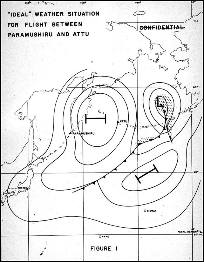
Before the first mission was planned, it was thought that the scheduling of the contemplated operations would depend on the existence of a very specific pressure configuration in the vicinity of the Aleutians. The ultimate ideal of flight conditions would be achieved by the presence of a high pressure wedge between the target and base, oriented in such a way that the western edge would govern the circulation at the target and the eastern edge, that at Attu. (See figure I.) In a pressure system such as this, a marked inversion at about 8,000 feet might be expected and, if present, would preclude the development of swelling cumulus. Although some cloud cover was desirable, particularly over the target, mission requirements made it essential that there be breaks in the clouds. The pressure gradient within the wedge was to be such that the wind velocity would be less than 25 knots. This weather pattern was to be sufficiently stable to persist for a period of at least 12 hours.
A study of Aleutian weather indicated that the conditions as outlined above would prevail only infrequently. Although the first mission had still not been attempted, Commander, Fleet Air Wing FOUR determined that it was necessary to
--4--
--5--
Acceptable Weather Pattern
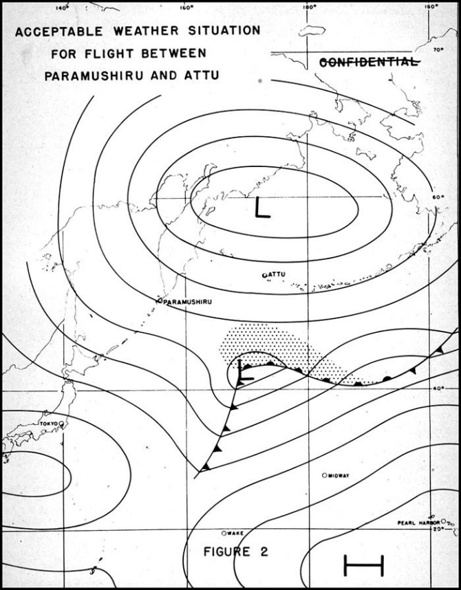
accept a second weather situation as satisfactory for strike operations. As an alternative, an elongated east-west low pressure area over the Bering Sea was considered adequate. (See figure II.) Circulation in this pressure configuration would give westerly air flow along the route and a series of weak cold fronts in a north-south orientation moving from Asia toward the American continent. The frontal area (where unfavorable flying weather might be encountered) was narrowly defined. This zone could be no more than 80-100 miles in width and had to be moving eastward with a velocity of at least 18-22 miles per hour. A few towering cumulus giving snow showers were allowable in the frontal zone but along the remainder of the route, cloud tops were to be below 8,000 feet. A temperature inversion at a level not to exceed 10,000 feet was desired to limit the vertical development of clouds. High broken clouds were permissible along the route and over the target as was a non-merging layer of alto and strato clouds at 4,000-5,000 feet. Except in snow shower areas, cloud bases were to be at least 1,500 feet and visibility unrestricted. The wind requirement still called for the same 25-knot maximum average except that turbulence and gusts up to 35 knots were permitted within the frontal zone. Minimum icing above, between, and below the cloud decks was demanded so that, as the necessity arose, flights could penetrate any of these regions.
After the successful completion of several missions, the experience gained in flying Aleutian weather and the increased confidence in the accuracy of forecasts made in this region resulted in further modifications. However, the definitions of what constituted acceptable flying weather were never relaxed in their precise nature. The "GO" or "STOP" signal for the "Empire Express" invariably was the Wing Commander's decision after a "weighing" of information from the weather plane pilot, aerological observer in the weather plane, staff aerologist, and staff considerations.
Pilot Briefing
Particular attention was paid to the pilot's preparation for each strike. The Wing Commander believed that maximum efficiency could be obtained only by the most careful briefing. A quonset hut fitted with theatre seats served as the briefing room where the pilots assembled for instruction by the operations, intelligence, and aerological officers. To insure clarity and completeness of understanding of flight conditions, the weather map was not merely displayed at the front of the room. Arrangements were made to project the map on a screen so that it would be equally visible to all concerned with the briefing. In addition to this display of the current weather map, cross-sectional representations of the atmosphere as forecast for mid-point time of flight were projected on the screen. A complete discussion and summary of the weather situation was given simultaneously by the aerological officer. To illustrate the attention give all details during briefing, it is worthy of note that lighting in the hut was such as to promote the night-adaptability of the pilot's eyes. Complete flight forecast folders with "howgozit curves" were placed in the hands of each pilot of the "strike group".
Forecasting Aids
With the weather requirements clearly outlined, it was necessary to arrange
--6--
--7--
procedures in such a way as to insure accurate forecasting. It was mandatory that a forecast of favorable flying conditions be essentially correct and important that no opportunities for running a successful strike be lost due to an incorrect forecast of poor flying weather. The forecasting difficulties resulting from sparse reports have already been pointed out. What remains, therefore, is a description of how Commander, Fleet Air Wing FOUR overcame these difficulties.
The broadcast weather information permitted the drawing of a weather map every six hours complete with respect to all portions east of Attu where land existed. Search planes flying over the region west of Attu were required to return with weather reports for the region of their flights. Although these reports were not always obtained at the same time as those from regular sources, they did facilitate, to a great extent, the drawing of the western portion of the map. From time to time, a tender was stationed west of Attu to make weather reports at daily irregular intervals to supplement the data obtained from aircraft weather reports.
As a further check, whenever a doubt remained concerning the weather prevailing between Attu and Paramushiru, a weather plane could be detailed to fly through the doubtful region, with an experienced weather observer or aerological officer aboard who "could see for himself."
In addition to the weather data acquired by the Wing in this way, the structure of the upper air could be deduced from the radiosonde, rawin and pilot balloon runs made at the base or a nearby island.
As a final precaution, a "guinea pig" run was made for each type of aircraft employed for the missions. These runs attempted to duplicate flight conditions in every way except that their line of flight extended not from Attu to Paramushiru and back but between Otter Point, Umnak Island and Agattu Island. Following a "guinea pig" run, it was possible to see the effect of the prevailing icing conditions, wind velocity, flight altitude, and other operational considerations on the performance of the plane.
The Strikes
During the period December 1943 through May 1944, 41 strikes were completed. The military effectiveness varied considerably but the noteworthy point is that during this time the loss of only one plane could be attributed to adverse weather conditions.
When operations proceed smoothly and on schedule there is usually little that is remarkable to be said concerning them. The four missions which are discussed in the following section were not selected because they were outstanding from any particular viewpoint but rather because they illustrate clearly various applications of the methods used by Commander, Fleet Air Wing FOUR in solving the operational weather problem.
--8--
Strike I
20 December 1943
This strike has been selected for discussion not only because it was the first undertaken by Fleet Air Wing FOUR while it was based on Attu but also because the weather pattern was as close an approach to the ideal as any other in the period between December and the end of May.
For a period to two weeks after a state of material readiness was first obtained at the base on Attu, cyclonic activity in and around the Sea of Okhotsk and across the route to Paramushiru made for adverse flight conditions. The first indications of a trend toward acceptable flying weather were apparent on 17 December, three days prior to the actual mission. A wedge of cold polar continental air extended north-northeast to south-southwest across the Bering Sea to Latitude 50 degrees North, crossing the Aleutian chain in the vicinity of Dutch Harbor with the axis moving westward. The movement progressed steadily and by 0800 local time 19 December, it was forecast that in most respects conditions for accomplishing the mission would be ideal by the evening of 20 December (take-off time to be 2200).
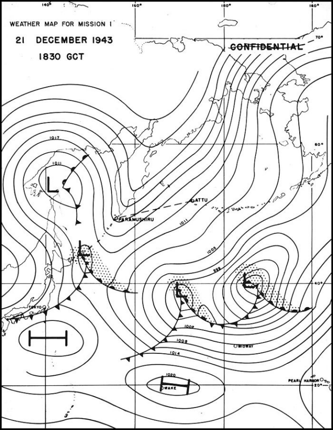
The following synoptic and meteorological conditions were noted on the 19th (see map, page 10):
1. A subsidence inversion existed at 8,000 feet which was expected to lower and sharpen in 36 hours giving almost dry air aloft at Attu. Cloud tops would be restricted to low altitudes.
2. Winds aloft obtained from Shemya Island on 19 December, although 30-35 knots below the inversion, were forecast to diminish. Above the inversion, winds would be less than 25 knots.
3. It was expected that the axis of the wedge would be along the Kamchatka peninsula during the mission.
With the axis of the high pressure wedge lying directly over the target, it was possible that there would be but few breaks in the cloud cover and more probable that the skies over the target would be overcast. East winds blowing against mountains just west of the target might result in the piling-up of clouds over the target giving a 2,000 foot ceiling, frequent snow showers and an overcast over eastern Paramushiru.
The possible presence of this unfavorable cloud cover did not necessitate postponement of flight. The absence of fronts along the route and the occurrence of light winds which would not increase in velocity during the flight indicated that as far as weather was concerned, the safety of the planes en route was insured. Terminal conditions for take-off and return would be entirely satisfactory. It was estimated that there was a 50 per cent chance of complete success for the strike.
Orders were issued at 1200 local time 19 December to prepare for a mission at 2130 on the following day. The mission forecast was confirmed by search
--9--
--10--
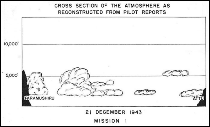
plane observations within 150 miles of the target and by the determination of upper wind direction and velocity at a nearby island. Upper air soundings proved the existence of a temperature inversion of 4 degrees centigrade at 6,500 feet.
| Forecast for Strike | Pilot Reports | ||
|---|---|---|---|
| Weather: | Occasional snow showers. | Snow squalls ceased upon departing from base and the weather continued good the entire route. | |
| Cloud cover: | Broken | Broken. Target overcast with few breaks (9/10). | |
| Ceiling: | Base at 2,000 feet, tops at 6,000-7,000 feet. | Tops at 7,000 feet. No high clouds. | |
| Icing: | Minimum icing above inversion with no clouds and low humidity. | No icing. | |
| Visibility: | Unrestricted except in squalls | ||
| Wind: | Winds above inversion northeast 20-25 knots for first two-thirds of route; east-southeast 20-25 for remaining third. | Winds above inversion northeast 20-25 knots for first two-thirds of route; east-southeast 20-25 knots for remaining third. |
--11--
Incendiary and general purpose bombs were dropped and excellent photographs of the target area were taken through the breaks in the clouds.
Strike 2
30 December 1943
The planning and execution of the second strike undertaken by Fleet Air Wing FOUR illustrate the use made of the alternative set of weather conditions as set forth in the earlier section called "Flight Planning". The mission, like the earlier one, was to be a combined photo-reconnaissance and bombing operation employing PBY-5A's.
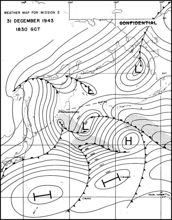
For several days subsequent to the decision to conduct this mission, a low pressure center off the western coast of lower Kamchatka gave positive indication of overcast conditions over the target. Until this center moved off beyond Attu, flight was inadvisable.
On 29 December, the 1230 GCT map showed the development of an occluding wave approximately 600 miles southwest of Attu. Since this disturbance was expected to travel eastward and remain south of the route, good flight conditions were anticipated for the night of 30 December. Final decision and orders to attack were issued at noon on that day, the final favorable weather forecast
--12--
--13--
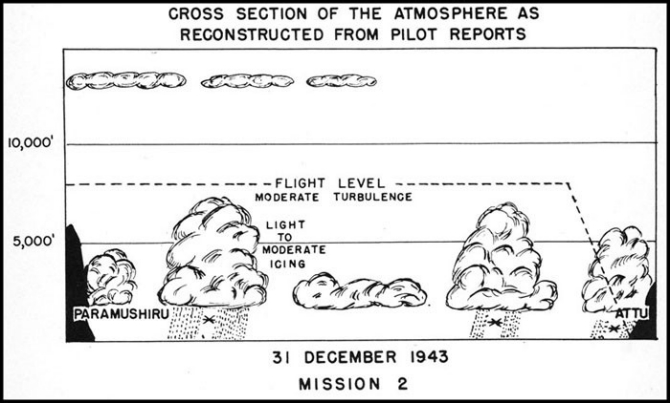
having been made from the 1230 GCT map. It was deduced that the original occluding wave had moved to a point approximately 300 miles south of Attu giving light northeast to northwest winds along the route. Another occluded wave was located just off the east coast of Sakhalin Island, and, at a normal rate of movement, the occlusion could be expected to give a precipitation ceiling at the target at the proposed time of attack. The circulation about this system was such, however, that the occlusion could be expected to dissipate as it approached Kamchatka, the broken occlusion sweeping northward about the original low center. A new wave cyclone would develop as it crossed the Kuriles but there was at least a 50-50 chance of the mission being completed prior to this development. The actual weather conditions encountered are indicated by the map, page 13, and the cross section, page 12.
| Forecast for Strike | Pilot Reports | ||
|---|---|---|---|
| Weather: | Snow showers (1-2 per hour) | Snow squalls. | |
| Cloud cover: | Lower broken (6/10-8/10) throughout, with high broken over target. | Target, lower clouds 7/10. High broken clouds over target. | |
| Ceilings: | 2,500 feet at terminal and en route, 1,500 feet over target. Tops of lower clouds over target 11,500 feet. | Tops of lower clouds less than 7,500 feet. Base of broken high cloud deck 13,000 feet. | |
| Icing: | Light to moderate below 7,000 feet. Minimum above lower clouds and between cloud layers over target. | Light to moderate icing. | |
| Visibility: | Unlimited above lower cloud deck. Ten miles below lower cloud deck. Less than four miles in showers. | ||
| Wind: | Surface, northeast-northwest 15-20 knots. 7,000 feet, northwest 15-20 knots. | Northeasterly 15-20 knots becoming northwesterly over target. |
Strike 23
24 April 1944
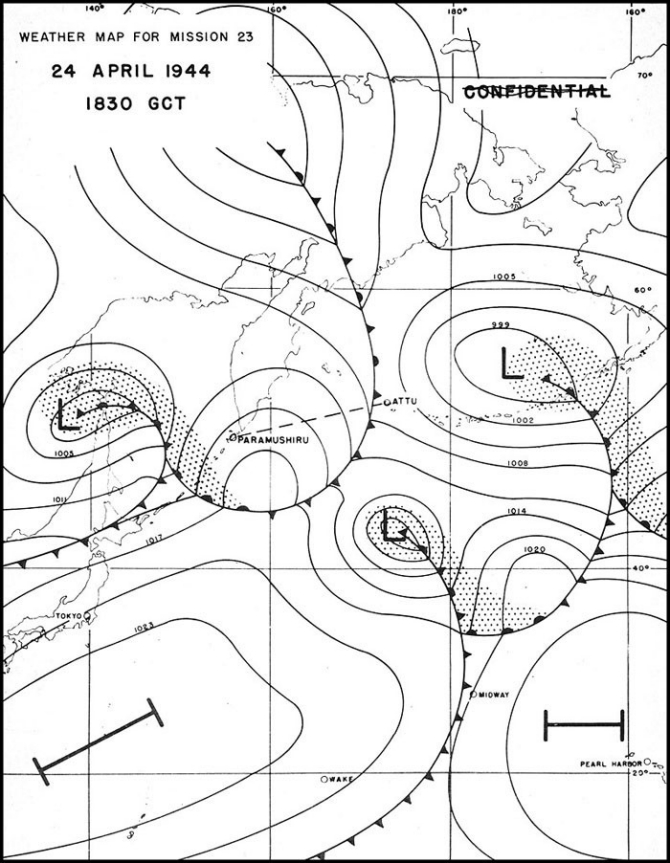
The necessity for accurate timing of the rates of movement and dissipation of frontal systems along the route and the benefits gained when this was accomplished can be illustrated by means of Mission 23.
--14--
Analysis of early synoptic weather maps showed that an occluded front had passed over the western portion of the Aleutian chain and that another center had developed well south of the west end of the chain. Regular Wing search planes were, however, unable to locate the center on the morning of 22 April. By the morning of 23 April, a weak cold front was known to be oriented northeast-southwest across the route but, except for this, conditions along the mission route were thought to be favorable. In the early afternoon, a special weather plane sent out to inspect the front was unable to pierce it or top it at 12,000 feet. Despite this, it was expected that a late take-off (i.e., after midnight) would allow sufficient dissipation of the front so that it could be topped with little icing and turbulence at mission flight level.
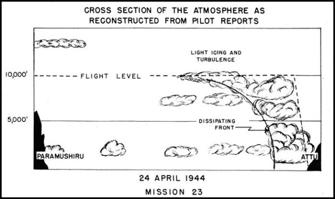
Accordingly, the Wing Commander ordered take-off for the night of 23 April but with the provision that no take-offs be earlier than local midnight. The point of added delay in allowing dissipation of the front was aptly proved. A strike group from a separate command took off the same night at about 2000 local time but was unable to pierce or top the front which they encountered 300 miles out. The front extended beyond the 13,000 foot level. Fleet Air Wing FOUR planes took off about five hours later as the other strike planes were returning. By the time that Fleet Air Wing FOUR planes intercepted the front they were able to pierce its thin top at 10,000 feet (regular flight level) encountering only light icing and turbulence. See map, page 16, and cross section below.
The four planes taking part in this strike all returned safely to base reporting with good pictures obtained in the target area. Bombing, too, had been satisfactory.
--15--
--16--
| Forecast for Strike | Pilot Reports | |||
|---|---|---|---|---|
| Weather: | Squall line 150 miles out (100 miles wide with cumulonimbus to 11,000 feet). Weak overrunning in target areas giving light intermittent snow. | Dissipating front. Temperature -7°C at 10,000 feet. | ||
| Cloud cover and ceiling: | Overcast first 250 miles becoming broken (7/10-8/10) rest of route. Target overcast at 2,000-3,000 feet. Variable layers to 11,000 feet at target area. Above 1,000 feet en route reducing to less than 500 feet in line of squalls. | Clouds at base topped at 10,000 feet with dissipating haze and could tops at midpoint of route, then gradually lowered to tops at 3,500 feet and scattered over Shimushu. Cloud tops (cumulus) around Paramushiru were above 14,000 feet chiefly because of mountains and prevailing westerly flow normal to mountain range. | ||
| Icing: | Light in squall line. | Light icing throughout front. | ||
| Visibility: | Over 10 miles reducing to less than 1 in squall line zone. | Dissipating haze at midpoint of route. | ||
| Wind: | Northwesterly 25 knots first 3090 miles, becoming westerly 10-15 knots then southwesterly in target area. | West-northwest - 15 knots first half becoming west - 12 knots western half. | ||
Strike 33
20 May 1944
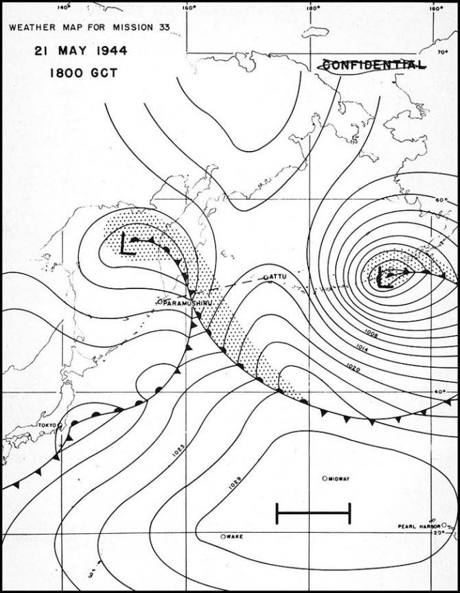
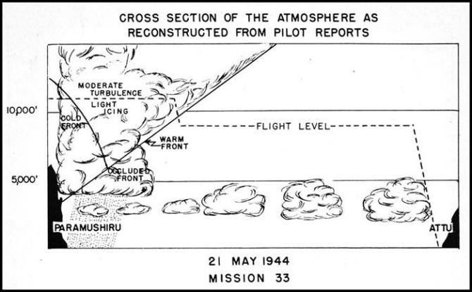
On occasion, a rapidly changing weather pattern made forecasting from the available data even more difficult than usual. When possible, under these conditions, a weather plane was sent out with an experienced aerologist aboard as observer. The information obtained from direct observation when tied in with the weather map permitted more nearly accurate weather analysis and prognostication than would otherwise have been possible. Mission 33 is an illustration of one which was postponed for more than 24 hours as a direct result of observational reports of this nature.
On the morning of 19 May, planes returning from an earlier strike reported evidence of a weak cold front along the route. Weather conditions had been favorable for their operation but radical change in the current weather situation could be expected. During the remainder of the day, the trend was favorable indicating the possibility that another strike might be scheduled to reach the target area in advance of an approaching weak occluded front. (See map, page 18.)
--17--
--18--
| Forecast for Strike | Pilot Reports | |||
|---|---|---|---|---|
| Weather: | Light showers in merged clouds east of target. | Showers over target. | ||
| Cloud cover and ceiling: | Overcast last half of route, merging 250 miles from target. At target: Top lower deck 5,000 feet; base upper broken deck 15,000 feet. Lower 6/10; upper 7/10. | Clouds topped locally at 5,000 feet with cirrostratus overcast encountered 300 miles out, merging with lower deck 540 miles out. Target overcast to above 12,000 feet. | ||
| Icing: | Light in merged clouds. Turbulence light. | Light to moderate icing and moderate turbulence. | ||
| Visibility: | Greater than 10 miles reducing to zero in clouds. | |||
| Wind: | West 10-18 knots; over target west-southwest, 20-25 knots. | Winds westerly 20 knots first half becoming southerly and increasing to 30 knots second half. | ||
--19--
Conclusion
Although this report covers the activities of Fleet Air Wing FOUR only during the period December 1943 through May 1944, strikes were flown throughout the remainder of 1944 and are still continuing. During the warmer months, icing considerations were less important, but fog and reduced visibility demanded the continued emphasis on aerological problems.
In view of the fact that the manner of attack employed by Commander, Fleet Air Wing FOUR in solving these problems remained sensibly the same, regardless of season and the specific nature of the weather problem, further discussion of the later missions will not be given here. Over 100 strikes have been completed to date with continuing success in combating adverse weather.
--20--
[END]
